Winter Storm Arrives Friday And May Bomb Off Coast Saturday
Wednesday Night March 8 2023
I have removed my doubt of this storm, but remain skeptical of the impact for our region. The set up on the weather map is not ideal, but perhaps close enough to get a cyclone that may try to Bomb Out along the coast on Saturday.
In fact the energy in the atmosphere is set up to produce two storms within a few days. The first arrives Friday ending Saturday, the second may race in Sunday night into Monday.
Storm Animation
GFS Model Friday morning to Monday Morning
Since the GFS performed best with the PA snow this week, it is getting more air time.
I have two model slider timelines below.

MY THOUGHTS
Given our rare low snow winter and late season date, I hope you understand my sincere caution with the words I choose for this storm. It is why I want to show you the set up for what to best expect with snow and or rain. However, I resist showing any snowfall potential given the obvious obstacles we face. I will restate them along with my First Call Map below.
If you missed my prior report, I showed many photos of late season snow stickage on the Eastern Shore in Maryland. It is possible in March and even April, so I still encourage an open mind for some surprises.
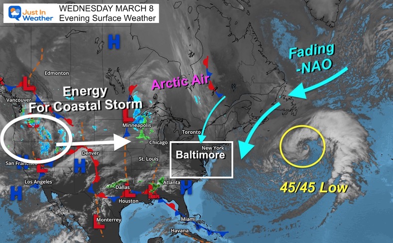
Wednesday Evening Set Up
WIDE VIEW MAP
I chose to vantage point to highlight a few things:
- A closed low in the Atlantic is located around 45N/45W. This is not the ideal 50/50 location but close enough.
- North Atlantic Oscillation is fading but is still NEGATIVE. That Ridge combined with the storm has played a role in our last few windy days. It may also help a developing Coastal Low stay closer to the coast.
- The energy that will produce this storm is still crossing the Rockies. It is a fast moving system, which with that Atlantic road block will help crank up the ‘SPIN’.
Upper Level Energy
Jet Stream Friday Morning To Saturday Evening
Watch the rapid development of that trough and Cold Core Low forming as it reaches the coast. On Saturday this is expected to rapidly intensify!
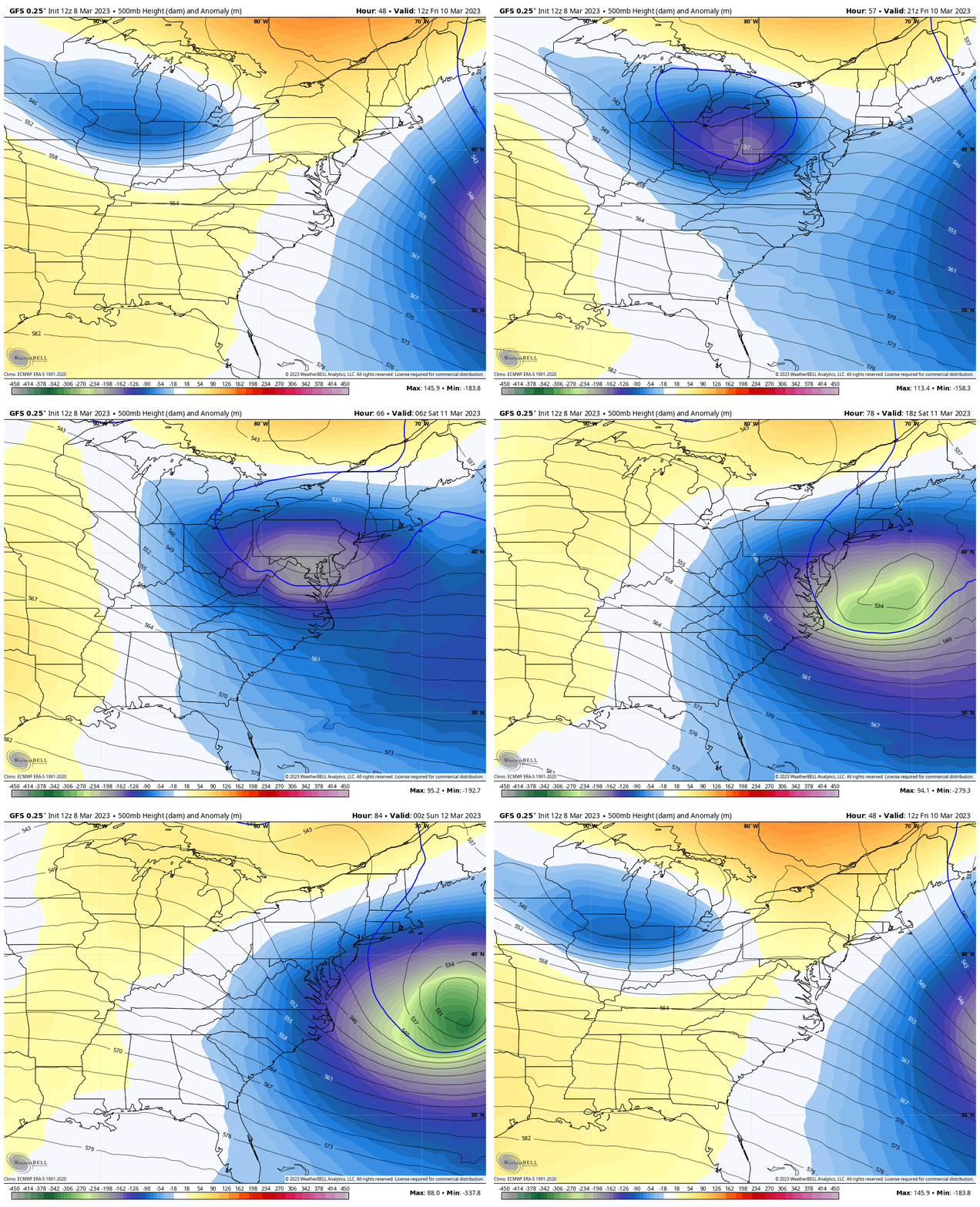
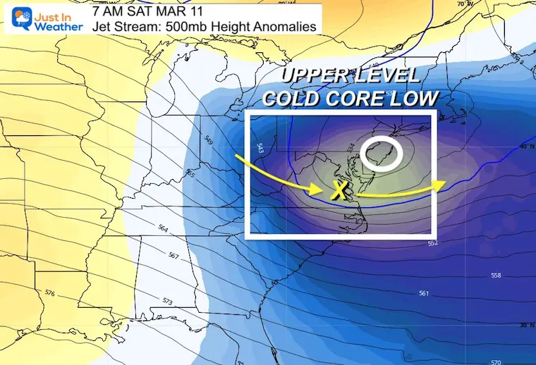
Snapshot Saturday Morning
The Upper Low is expected to be near Philadelphia and Atlantic City. This is north of Baltimore, so not ideal for a Mid Atlantic snow. However, the energy I plotted is tracking into southern Maryland. This will help pull in colder air and the backside of snow as the storm moves away. It will also help this storm Bomb Out off the coast.
Storm Notes
- We a lot of similarities between the GFS and European ECMWF.
- This may arrive earlier. That timing is key to establish the cold and maybe get stickage, for the places that are more prone.
- Primary Low will track into Western PA.
- Initial snow and mix will enter our region.
- Rain likely to push north through the evening and night.
- The Snow line will remain in far Western Maryland to Central PA. Travel may be impacted!
- Energy TRANSFER to New Low At Night.
- Saturday Morning: Coastal Storm will deepen rapidly.
- A BOMB is an air pressure drop of 24 mb (millibars) in 24 hours. This will drop 20 mb in 12 hours.
- The result will pull in colder air and perhaps the snow down back into Maryland.
Model Comparison
GFS Model Timeline —> Slider
ECMWF Model Timeline —> Slider
This may be a little faster (it was slower the past few days). It also shows a stronger coastal Low and a bigger impact on the back end with snow Saturday morning.
Other Models: Arrival Set Up
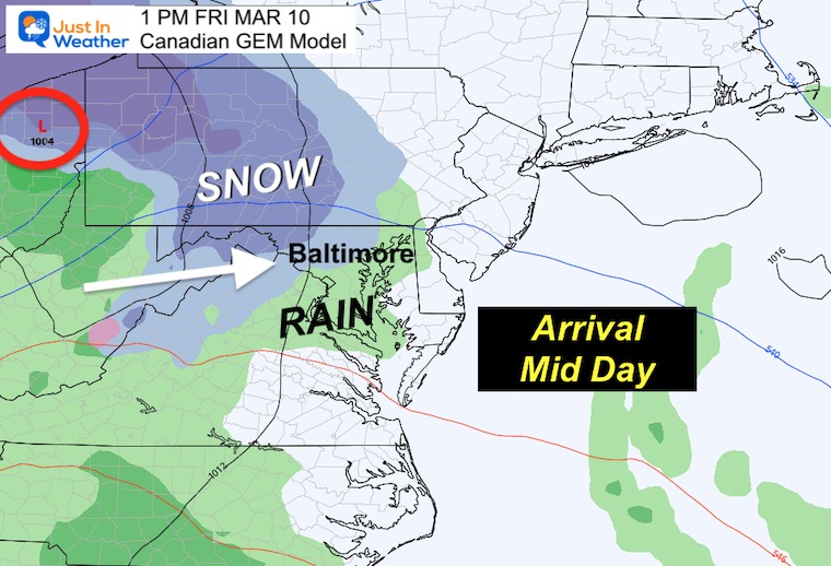
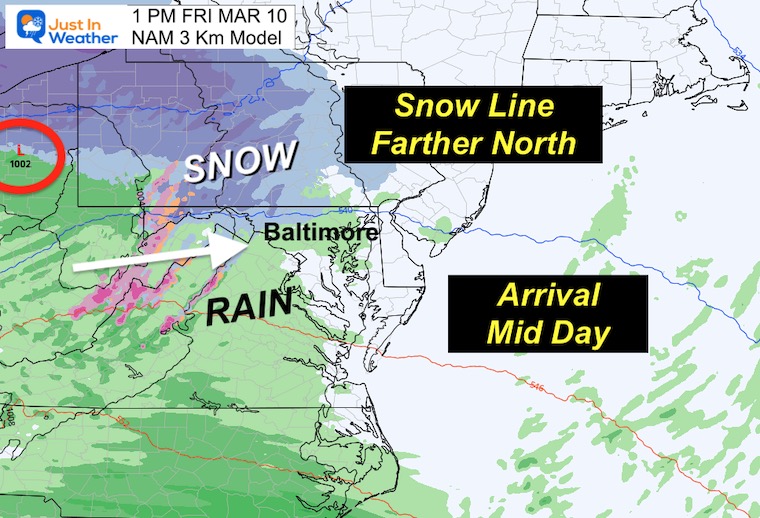
Both the NAM 3 Km and Canadian GEM show the leading edge midday. That would restrict any snow impact for most of our region starting so late.
The Canadian was the farthest NORTH and warmest, but it is back in line with the other models.
Canadian GEM
NAM 3Km
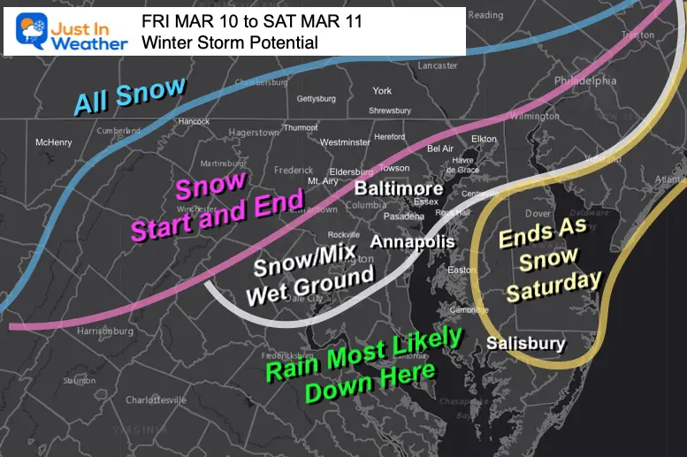
My First Call For Snow Impact
This is my best simplified expectations. I will NOT suggest snow amounts yet.
It is favorable for inland areas AWAY from the Chesapeake Bay and in the higher hills. This does not favor urban, coastal, or Delmarva locations. However, that Coastal formation and timing in the morning could bring them snow before sunrise to have the best chance to lay a coating.
Most likely I will take any model suggestions for snow totals and LOWER THEM to account for melting AND the tendency to push north at the very end.
Realistic DOUBT About Snowfall In March
- Snow falling during the day has more hindrance to stick with the higher March sun angle.
- The ground will have a few nights of freezing temps to chill, but will still retain plenty of latent warmth.
- The coastal Low Bombing Out is a wild card with the transfer of energy, pulling cold air in, and back end snow for Delmarva.
- The bias of this model (among others) all winter, has been to plot storms farther south than they verify.
If you want snow, you want the track farther south than shown here. If this ends up north, it would diminish snow chances.
ALSO SEE
REPORT: March Snow and Extreme Weather History
March Snow and Extreme Weather History
Subscribe for eMail Alerts
Weather posts straight to your inbox
Sign up and be the first to know!
IN CASE YOU MISSED IT
My REALISTIC Expectations for the COLD OUTLOOK
Winter History: Low Snow And Late Starts
See my research based on Baltimore data since 1883.
RESTATING MY MESSAGE ABOUT DYSLEXIA
I am aware there are some spelling and grammar typos, and occasional other glitches. I take responsibility for my mistakes, and even the computer glitches I may miss.
I have made a few public statements over the years, but if you are new here you may have missed it:
I have dyslexia, and found out during my second year at Cornell University. It didn’t stop me from getting my meteorology degree, and being first to get the AMS CBM in the Baltimore/Washington region. One of my professors told me that I had made it that far without knowing, and to not let it be a crutch going forward. That was Mark Wysocki and he was absolutely correct!
I do miss my mistakes in my own proofreading. The autocorrect spell check on my computer sometimes does an injustice to make it worse. I also can make mistakes in forecasting. No one is perfect predicting the future.
All of the maps and information are accurate. The ‘wordy’ stuff can get sticky.
There has been no editor that can check my work when I needed it and have it ready to send out in a newsworthy timeline. Barbara Werner is a member of the web team that helps me maintain this site. She has taken it upon herself to edit typos, when she is able. That could be AFTER you read this.
I accept this and perhaps proves what you read is really from me…
It’s part of my charm.
#FITF
STEM Assemblies/In School Fields Trips Are Back
Click to see more and ‘Book’ a visit to your school
My Winter Outlook: Not A Typical La Niña!
I see many factors to support colder influence with multiple systems. Early and later in winter. Check it out. https://justinweather.com/2022/11/22/winter-outlook-2023-for-snow-not-typical-la-nina-plus-polar-vortex-disruption/
Also See The Winter Outlook Series:
Farmer’s Almanac Comparison
September Starts Meteorological Autumn: Weather Climate Stats For Maryland at Baltimore
Triple Dip La Niña Winter
https://justinweather.com/2022/09/09/winter-outlook-2023-la-nina-triple-dip-expectations/
CONNECTION TO WINTER?
If you want a snowy winter, this is what you might want to look for in the rest of the tropical season. https://justinweather.com/2022/08/31/record-august-for-no-named-tropical-storms-closer-look-at-snow-following/
Woolly Bear Caterpillars
https://justinweather.com/2022/10/25/winter-weather-outlook-from-the-wooly-bear-caterpillar/
Persimmon Seeds
Click to see Top 20 and MORE
Normals And Records: Maryland and Baltimore Climate History
Please share your thoughts, best weather pics/videos, or just keep in touch via social media
-
-
Facebook: Justin Berk, Meteorologist
-
Twitter: @JustinWeather
-
Instagram: justinweather
-


