February 22 On The Edge Of The Winter Storm Then Record Warmth
February 22, 2023
Wednesday Morning
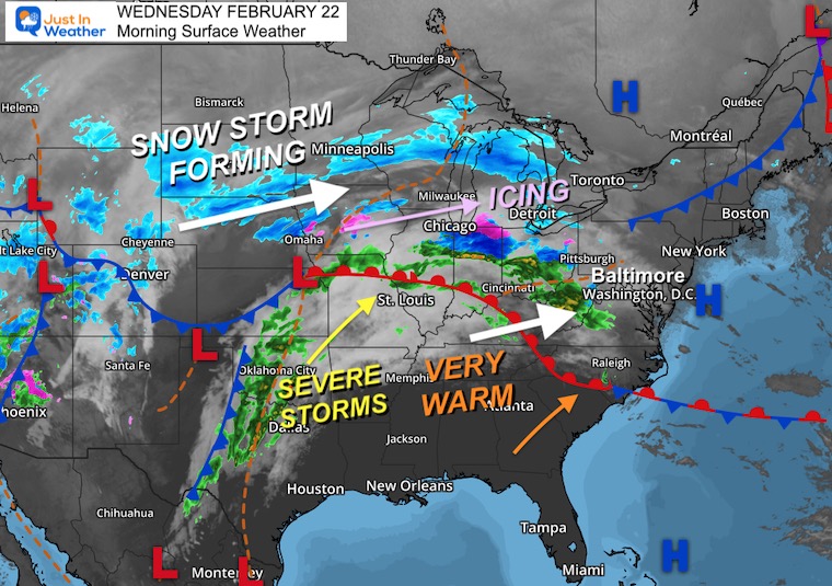
A major winter storm is affecting most of the nation today. On the north side, up to 2 Feet of snow is expected. There is also a region of icing into Michigan. But here in the Mid Atlantic, we just get the southern edge and a few hours of rain.
This may mix with sleet briefly for the northern suburbs of Baltimore to southern PA. I mention this so there is no surprise, but there should be no travel impact.
After this storm passes by, we open up the furnace! Sort of… Temperatures will soar into the 70s, and will challenge one of the oldest records on the books (computers) dating back 149 years.
This weekend will turn colder again, and I am still watching the same old routine… Models show snow, then lose it, then it comes back. I am putting ‘flurries’ on my forecast to highlight I expect something but not a big deal.
Eye Candy Photos
In case you missed this on social media, I wanted to show the best sky show!
Low Rainbow
After the squall on Tuesday, a rainbow appeared low on the horizon. This was due to the angle of the sun in February with a rain shower that we rarely mix together.

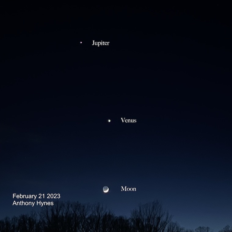
Evening Space View
Jupiter, Venus, and the Crescent Moon were in a beautiful alignment.
Back To Today’s Weather
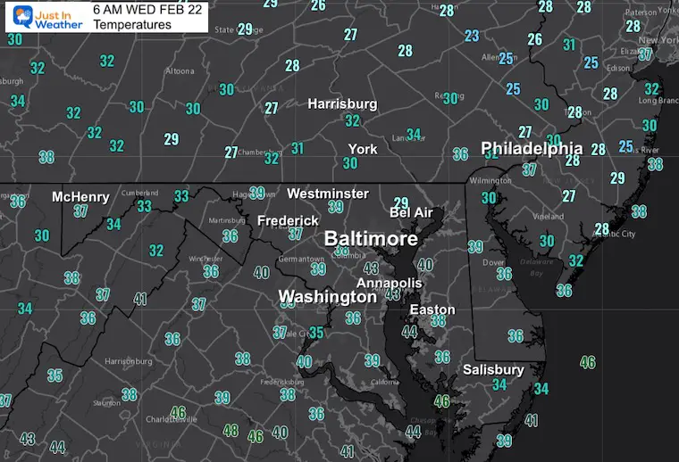
Morning Temperatures
Back to the colder air, and notice some regions are in the 30s. There is cold air in the atmosphere, but warming is associated with the band of rain.
Morning Surface Weather
This is a late storm and there will be a lot of snow… just not here. TWO feet are forecast across the Northern Plains. Icing in Michigan near Detroit.
There has been some wintry mix in the mountains of West Virginia, but that band is mostly rain. It may mix with some sleet as it arrives, but briefly.
Live Radar Widget
Note, there is no winter precipitation coloring here. But you can control the view.
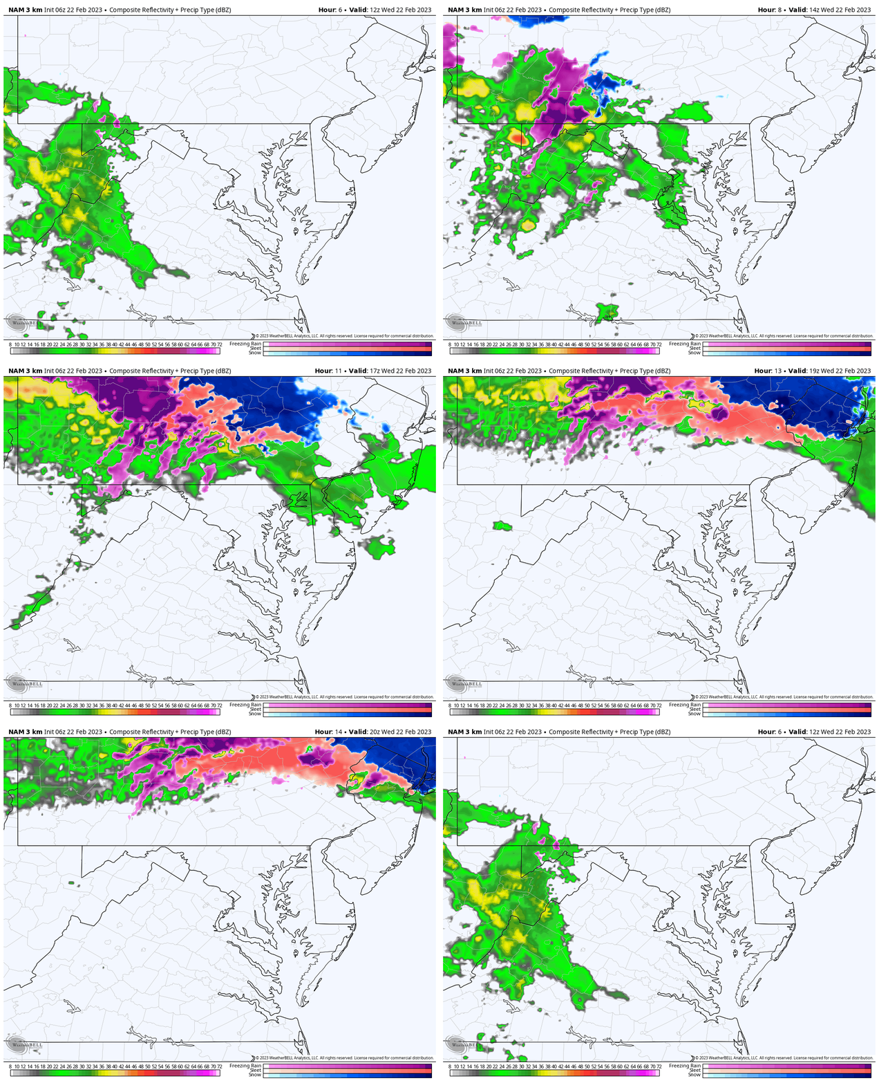
Radar Simulation 7 AM to 3 PM
We will watch ‘mostly rain’ arrive in central areas a little faster than earlier thought… That is another theme we’ve had all winter.
Plan between 9 AM to 2 PM for the best chance to get in on this.
If you see sleet, it will be brief, and during the first hour of this arriving.
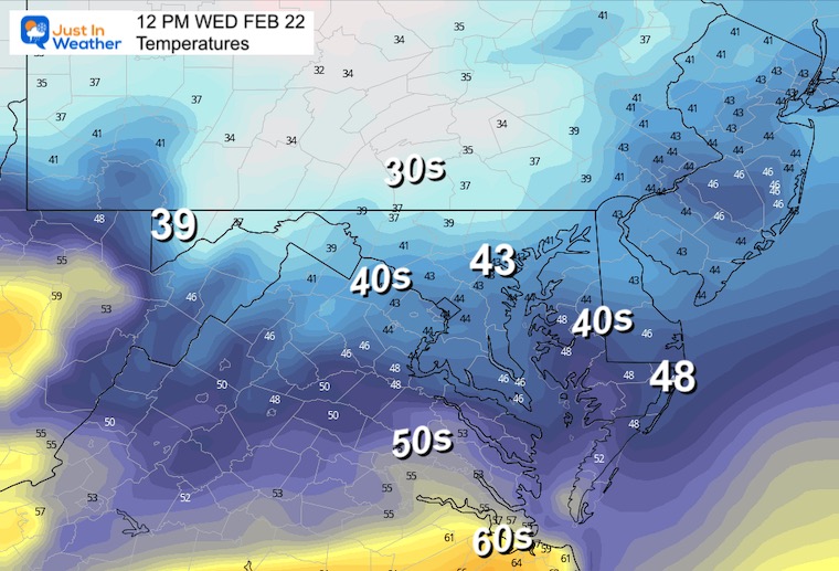
Temperatures
We will have a chilly day. These are numbers at noon, while the rain is here. After the rain ends, there may be a little bump on thermometers, but sticking in the 40s.
Subscribe for eMail Alerts
Weather posts straight to your inbox
Sign up and be the first to know!
CLIMATE DATA
TODAY February 22
Normal Low in Baltimore: 28ºF
Record 7ºF in 1963
SNOW: 4” in 1987
Normal High in Baltimore: 48ºF
Record 74ºF 1874
Thursday Weather
ALL ABOUT THE WARM UP
Temperatures
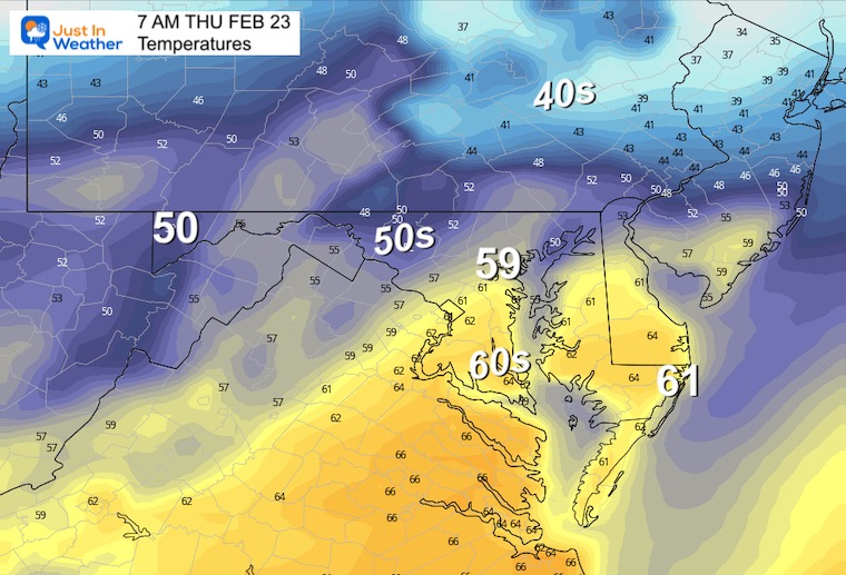
Morning
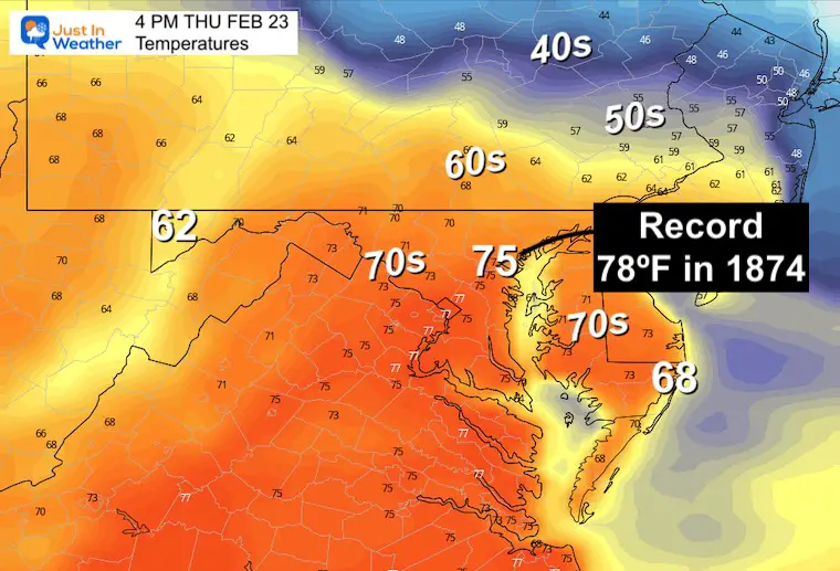
Already on the rise, the wake up numbers will be well above normal afternoon temps.
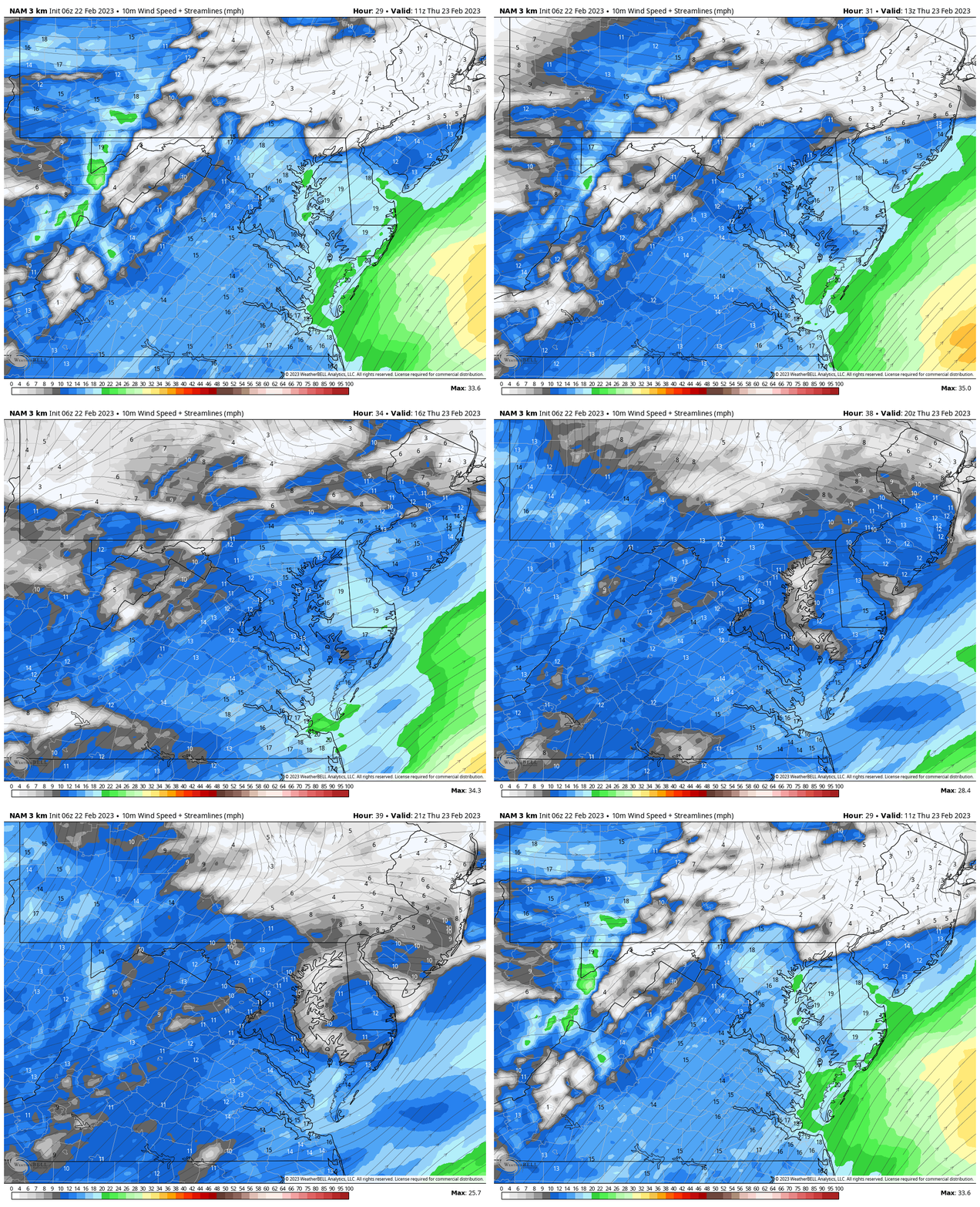
Wind Forecast:
The trade off for this warm air will be strong winds averaging 10 to 20 mph, gusting over 30 mph.
Afternoon
It was 78ºF in 1874 on Feb 23. That was 149 years ago! We often end up warmer than models show, which is why I am forecasting for that record even though it’s not shown here.
Note:
Colder air will arrive Friday and Saturday (another weekly theme).
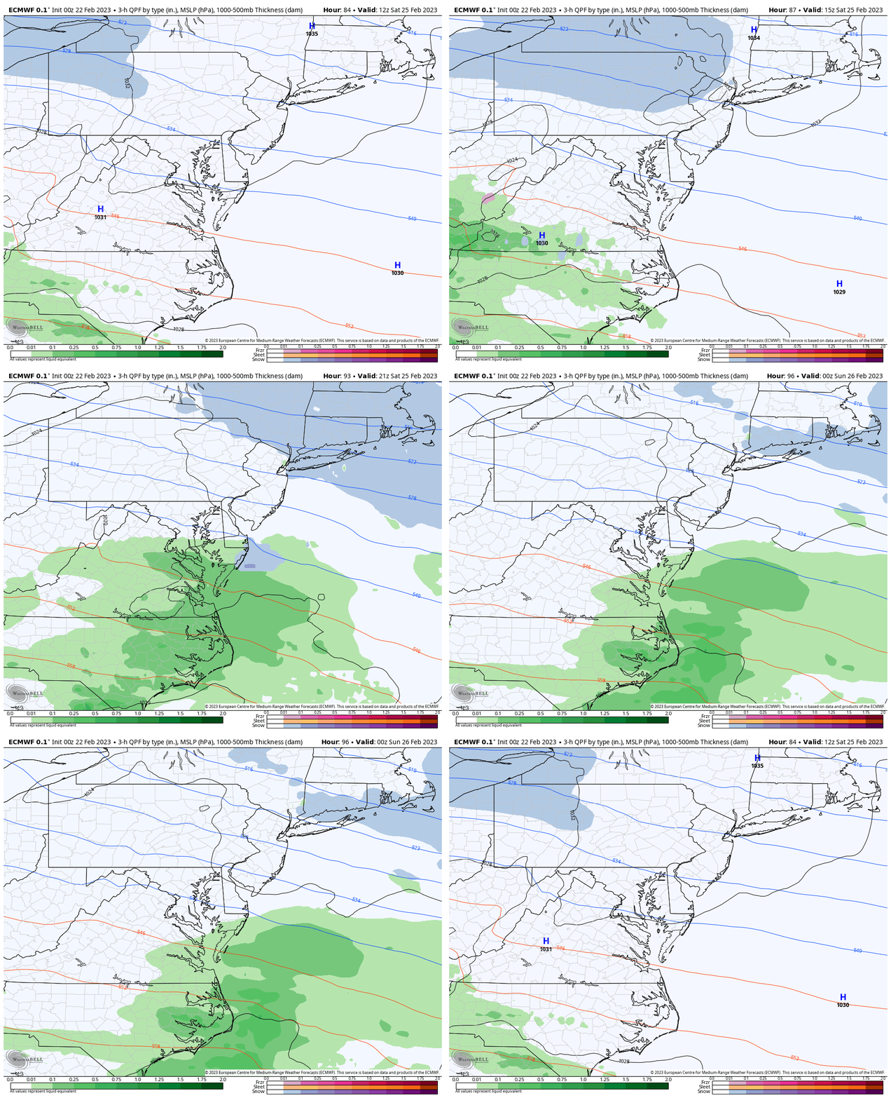
The next storm is not really a storm. This system is showing ANOTHER theme this winter. Models show something, then lose it, only for something to come back.
ECMWF Model: Saturday 7 AM to 7 PM
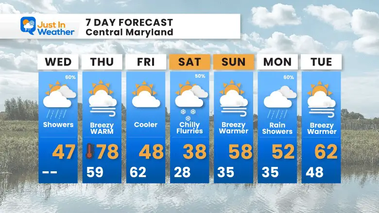
I am showing the European Model which had light snow yesterday, but now has split the energy. I believe it will come back together, however this will be on the light side. So when you see this in my 7-Day forecast, I have ‘Flurries’ with a 30% chance.
7 Day Forecast
I am holding the chance for Flurries on Saturday, but I don’t see much from this as of now.
Also See:
Winter History: Low Snow And Late Starts
See my research based on Baltimore data since 1883.
Subscribe for eMail Alerts
Weather posts straight to your inbox
Sign up and be the first to know!
STEM Assemblies/In School Fields Trips Are Back
Click to see more and ‘Book’ a visit to your school 
My Winter Outlook: Not A Typical La Niña!
I see many factors to support colder influence with multiple systems. Early and later in winter. Check it out. https://justinweather.com/2022/11/22/winter-outlook-2023-for-snow-not-typical-la-nina-plus-polar-vortex-disruption/
Also See The Winter Outlook Series:
Farmer’s Almanac Comparison
September Starts Meteorological Autumn: Weather Climate Stats For Maryland at Baltimore
Triple Dip La Niña Winter
https://justinweather.com/2022/09/09/winter-outlook-2023-la-nina-triple-dip-expectations/
CONNECTION TO WINTER?
If you want a snowy winter, this is what you might want to look for in the rest of the tropical season. https://justinweather.com/2022/08/31/record-august-for-no-named-tropical-storms-closer-look-at-snow-following/
Woolly Bear Caterpillars
https://justinweather.com/2022/10/25/winter-weather-outlook-from-the-wooly-bear-caterpillar/
Persimmon Seeds
Click to see Top 20 and MORE
Normals And Records: Maryland and Baltimore Climate History
Please share your thoughts, best weather pics/videos, or just keep in touch via social media
-
-
Facebook: Justin Berk, Meteorologist
-
Twitter: @JustinWeather
-
Instagram: justinweather
-


