


July 5 Heating Up And Tropical Storm Chantal Expected To Get Named Today
Saturday, July 5 2025 Morning Report After the beautiful Independence Day we just had, we will see a little increase in heat and humidity today and tomorrow. There is a…
February 21 2023
What if I told you we would have a severe thunderstorm followed by a rainbow, then rain with a little sleet, followed by a warm day near 80ºF that could break a 149-year old record, only to be capped by a little snow two days later. Oh wait, and all in the last week of February? If this was a Hollywood script, they would throw it out for not being believable.
Well, our winter without a winter still has some tricks up its sleeve, and we have a chance to see all of it this week. We are in a very unusual winter in the Eastern US, challenging some of the lowest seasonal snow totals while some top warmest winter months. There has been plenty of winter, just locked in for the western half of the country.
All winter we have been tracking one Polar Vortex disruption to another. Each time, our brief burst of cold air arrived on a weekend, and only lasted a day or two. So at the very hint of wintry weather, I understand dismissing the talk. I have lowered my expectations as well.
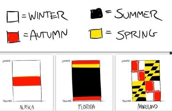
This is why this Meme of the Maryland Flag seems appropriate to show again.
One thing I recall from my college professor and even when I was teaching:
Also:
I know we have had many times with temps in the 70s then snow not far away. I found one extreme in the record books in Baltimore
I am not suggesting we will see a repeat, but there is more hope of something after today’s storm and Winter Folklore:
“If in winter there is thunder Snow may fall in one week or under”
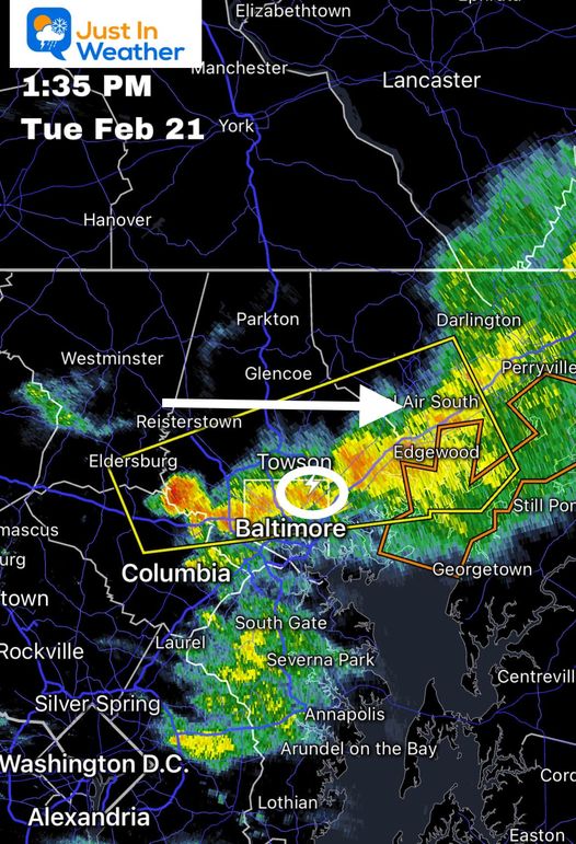
A squall line produced some lightning (and thunder), which I shared on social media.
Then a Severe Thunderstorm Warning was issued for central Maryland.
This was the snapshot at 1:35 PM, when lightning and hail was falling in the metro area.
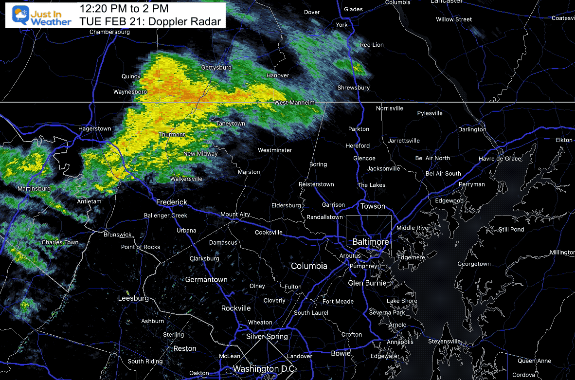
12:20 PM to 2 PM
This cell was moving at a forward speed of 65 mph! Most areas reported wind gusts between 40 and 50 mph.
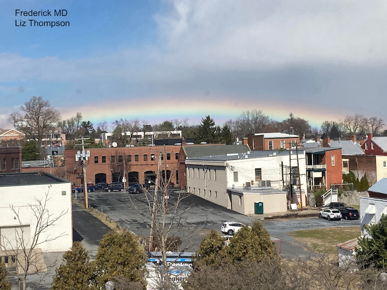
Photos from Frederick and Annapolis in Maryland both showed a low horizon rainbow seen following this storm.
This was due to the low angle of the sun in the February afternoon.

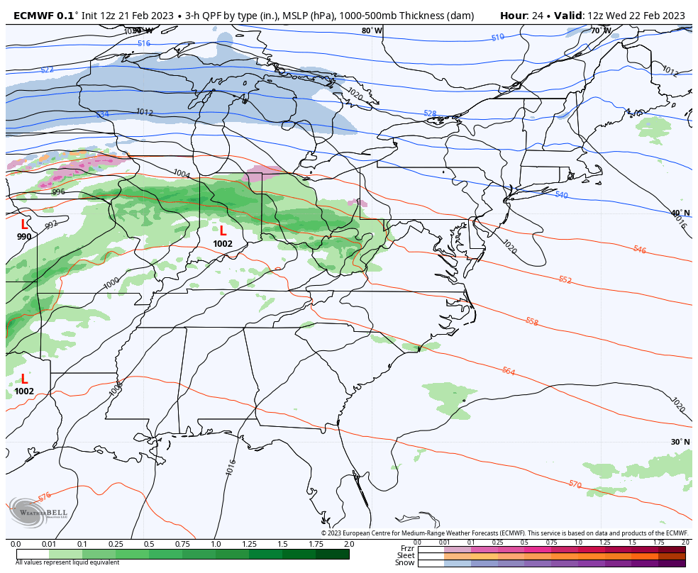
Wednesday Winter Storm
Here are the Watches and Warnings for this next event. There is plenty of winter, just not here (yet).
This follows the storm track to The Great Lakes, with a large area under a Winter Storm or Ice Storm Warning.
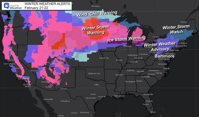
This is NOT our storm. However, it may begin with snow/sleet pellets mixed in. I do not expect a travel issue. Just some pinging on some windows, NORTH OF BALTIMORE! So in the city and south, you may just read about it online.
Imagine this: Millions of dollars invested with millions of calculations, and yet there is still a wide discrepancy for a weather event just one day away.
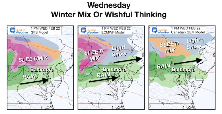
Until something special happens, I will continue to watch The European ECMWF as the benchmark for mid range events.
Wednesday Morning To Thursday Afternoon
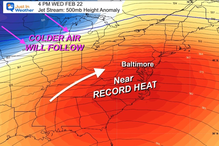
After this storm passes, the surge of warm air will flow in Thursday.
This storm buckled the upper air flow, allowing the surge of near record warmth.
This will not last, so enjoy it. Colder air will follow by the weekend.
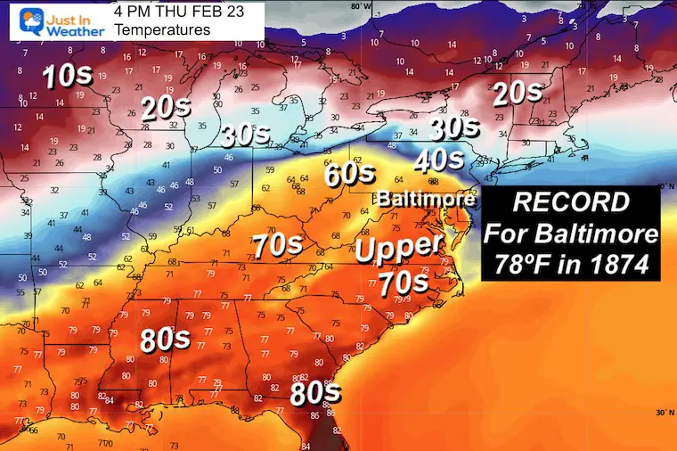
I am holding with our chance to hit one of the oldest records on the books. There was a 2-day heat wave in 1874. The second date was February 24 when Baltimore reached 78ºF. That was 30 degrees ABOVE average.
I mentioned this record last week, but I know it is not as impressive as a snow forecast so it will be forgotten unless I mention it 🙂
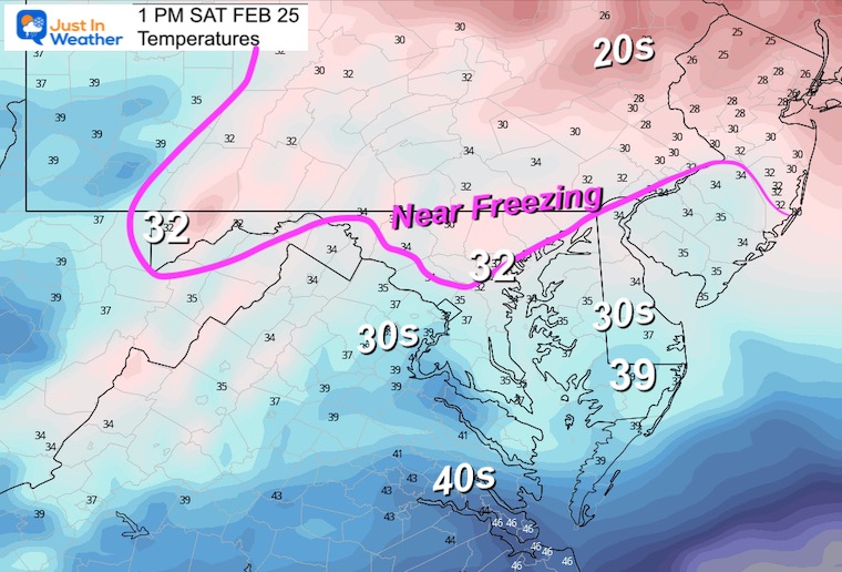
Notice the cold air in the snow zone. There are plenty of sub-freezing readings in that air mass that will arrive this weekend.
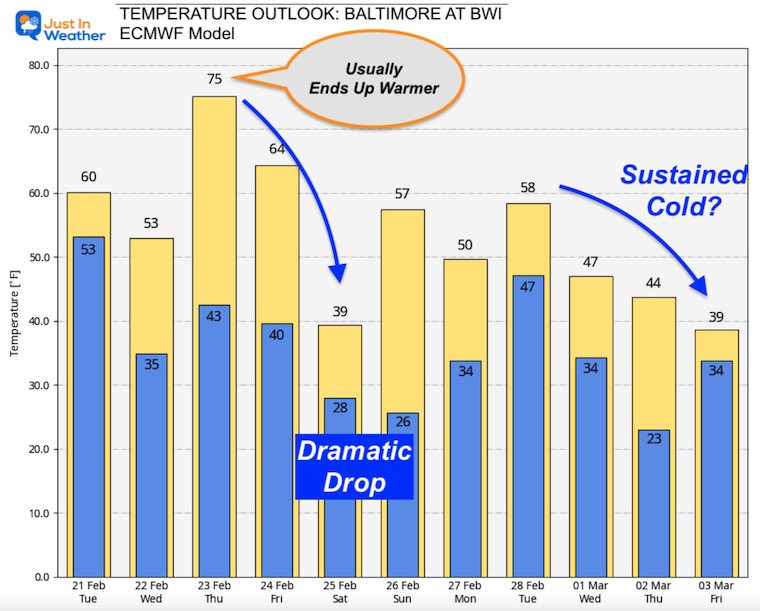
What goes up, must come down. Here is the European ECMWF Model plot.
I highlighted that it is showing only 75ºF for Thursday, but we often end up warmer than projected in these set ups.
The drop to 39ºF on Saturday might be deceiving. It may be colder in the afternoon, when snow may fall.
Looking farther out, the next push of colder air is plotted for the start of March. By that point mid 40s to 30s would be below average and could be more sustained than any cold spells we’ve had all winter.
ECMWF Model Forecast
Here we see a jet streak developing a region of precipitation across the Mid Atlantic and Southeast US. This includes a band of snow across central Maryland for a few hours. It is not a big event, simply a reflection of faster winds aloft.
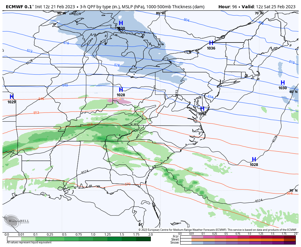
This is a 6 Hour summary between 7 AM and 1 PM.
I will NOT suggest this is a promise. It is a projection from this model and subject to change again. It is worth watching. There is support for an extreme flip and it is still winter. Stranger things have happened before.
Can it stick?
Honestly, even with this forecast of near Freezing, it is late February AFTER many warm days this week. It will be challenging at best to get stickage, and if so it would be more likely on the grass during the day, rather than roads.
We have had this theme often this winter: Very warm to end the week, then briefly very cold on a Saturday. This time is may be on both ends of the extreme. This is the kind of thing that can break a pattern, and just might arrive a little too late for those of us missing the winter we never had.
NO!
However, there was one winter with UNDER 1” in 1949 to 1950
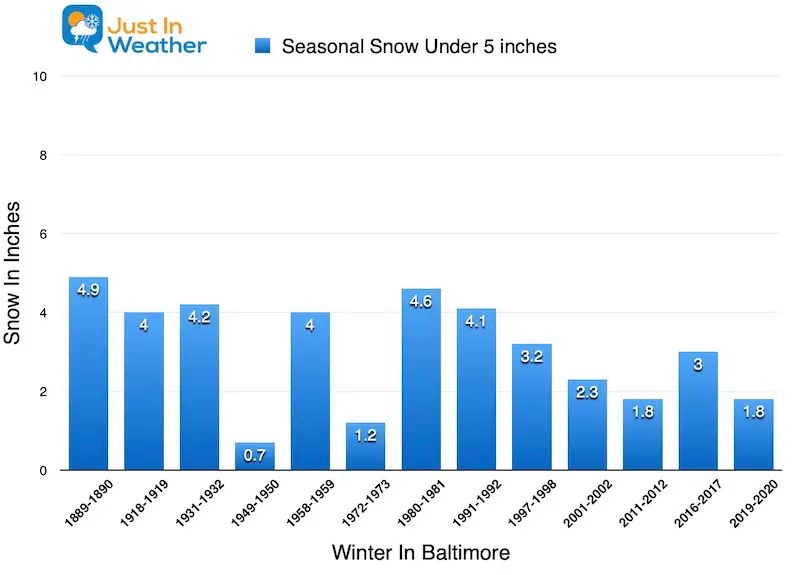
Winter History: Low Snow And Late Starts
See my research based on Baltimore data since 1883.

Click to see more and ‘Book’ a visit to your school 

