Cold And Light Snow Begin To Arrive On Tuesday
January 30, 2023
Monday Afternoon Update
This is a quick midday update on the weather changes on the way tomorrow. I just finished two FITF assemblies at Easton Middle School, and I told the students about the challenge of getting snow this winter. This week adds complexity with the arctic front and southern storm, plus the timing for our region.
As I mentioned in my prior report, the first taste of winter showing up will be on Tuesday across central Maryland. We still may have snow to discuss on Wednesday, but let’s focus on the short term for now.
Here is a look at the setup and a few model outlooks for Tuesday. It will not be a heavy event and will begin with warm ground. But if this progresses, we might see some work needed on area roads Tuesday night.
Set Up at 11 AM Monday
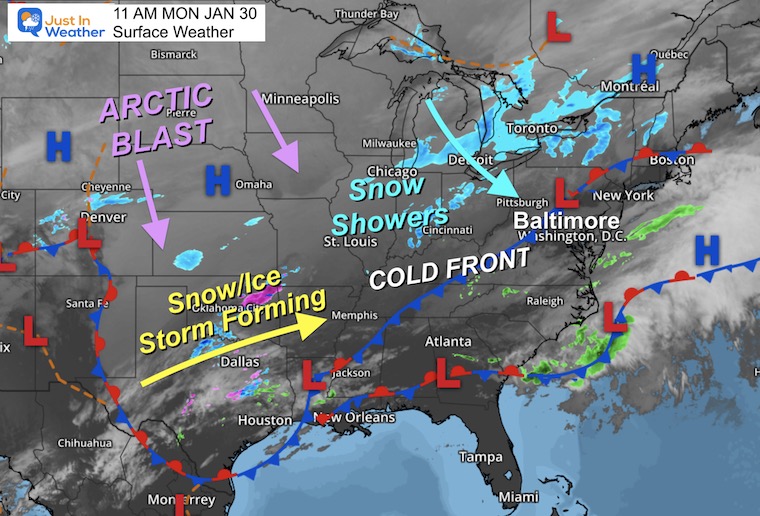
Surface Weather
The cold front is still just to our west across the mountains and crawling. This is the challenge with the progress in timing and how far it may reach. Light snow showers are falling on the other side, and it appears that will be our weather from Tuesday into Wednesday.
If you look at Texas (bottom center) on the map, there is light snow and ice near Dallas. There may be an ice and snowstorm developing there and expanding on the cold side of that Cold Front.
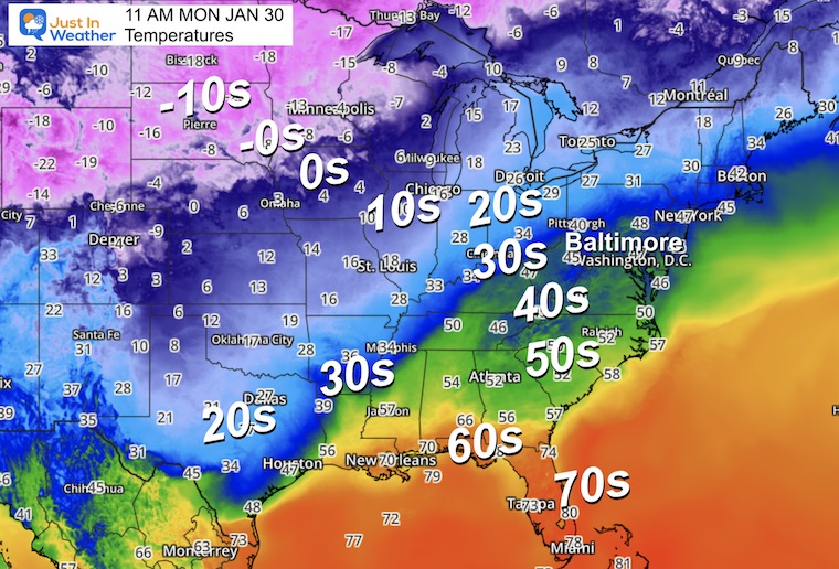
Temperatures
While we have an afternoon in the 50s, notice the 20s deep into Texas. Farther into that arctic air mass, temps drop well below zero across the Northern Plains. This is a potent block of cold air, but it is not moving fast.
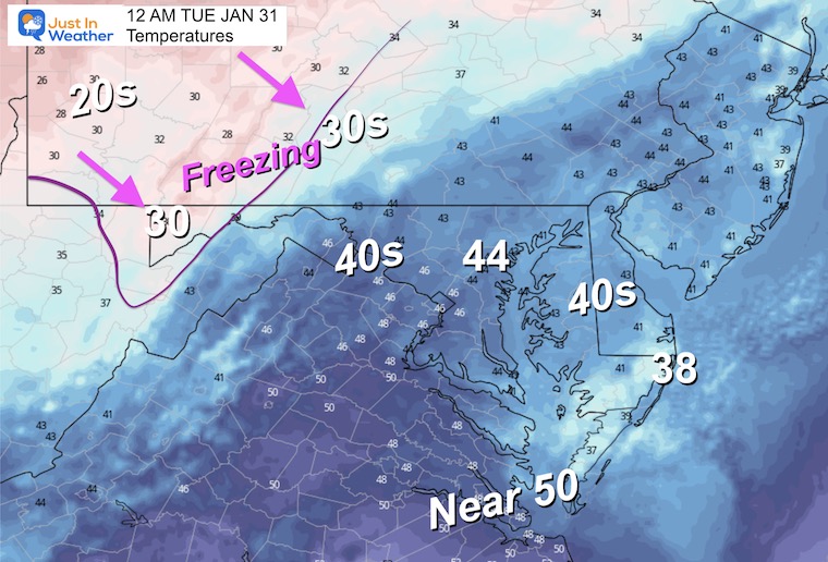
Forecast Midnight
Temperatures
Timing the movement and plotting the reach of that cold air is still a challenge. Here is where the freezing line may be tonight.
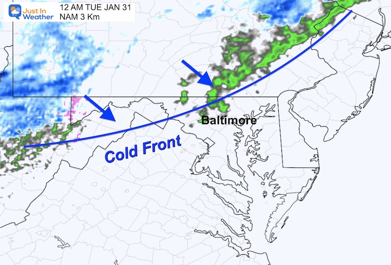
Radar Simulation
The front is forecast to cross into central Maryland with light rain. There may be some sleet mixed in.
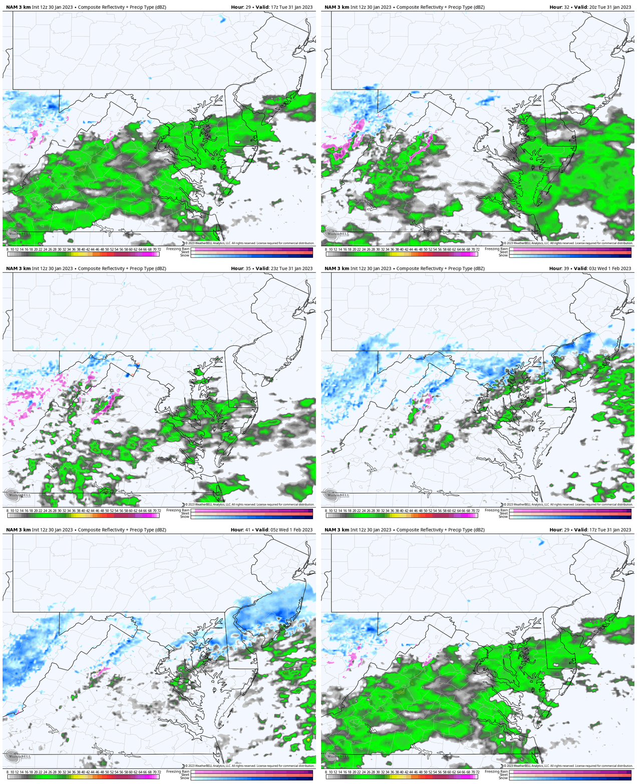
Radar Simulation
NAM 3 Km 12 PM To Midnight
The slow moving front may stall as impulses of showers will ride along it. If we get a chance for light sleet or snow it will increase later in the evening and at night.
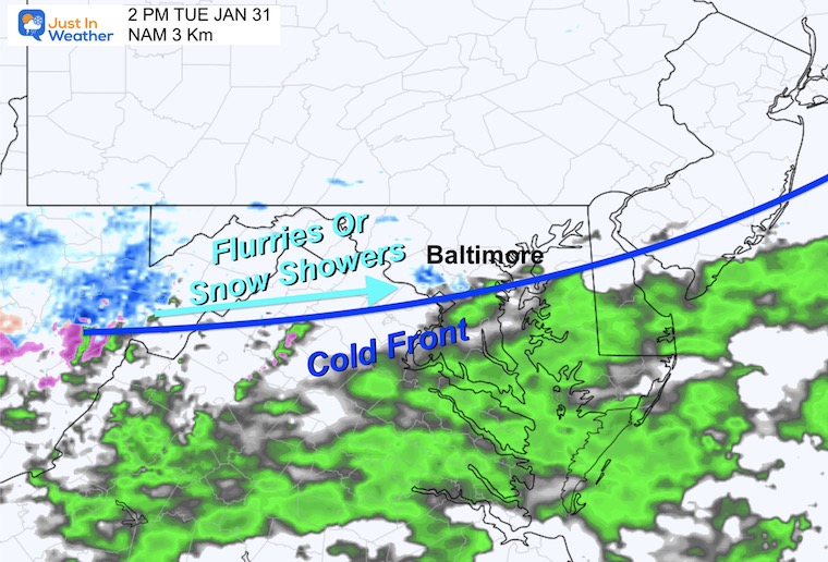
Snapshots
2 PM
Rain south of the front, with flurries or light snow on the north of the cold air.
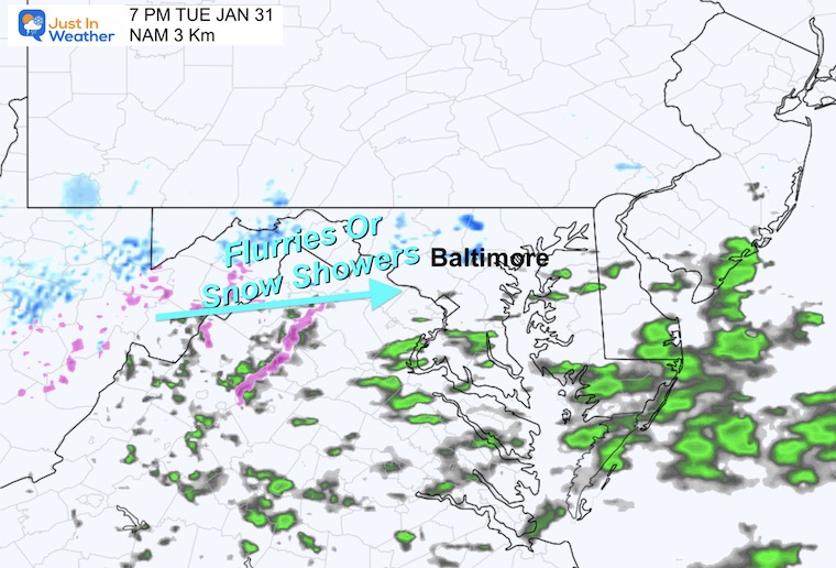
7 PM
Flurries and snow showers become a little more widespread.
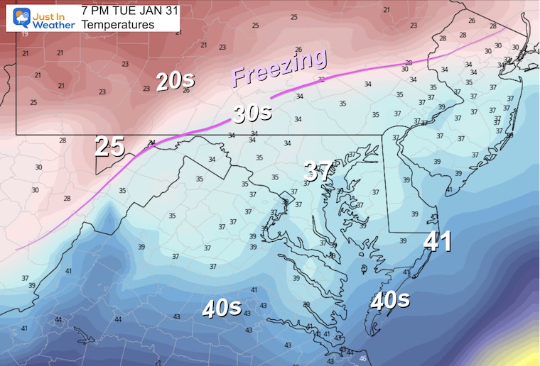
Temperatures
Notice while it will be cold and we get winter precipitation, the freezing line may still not fully be here. Roads will be wet, but that may change by Wednesday morning.
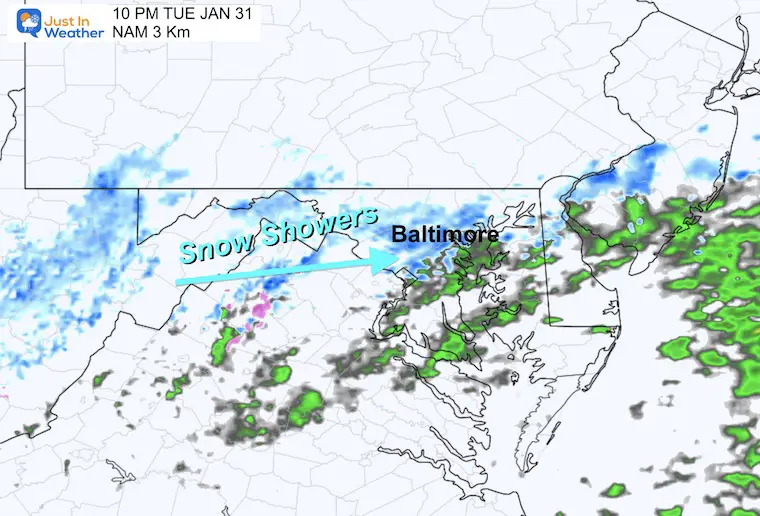
10 PM
As I mentioned, the coverage of precipitation will increase in the evening and at night.
Quick Model Scans:
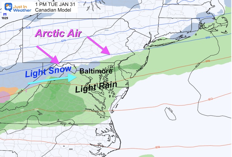
Canadian Model
This also shows the northern band of precipitation setup across our region with snow.
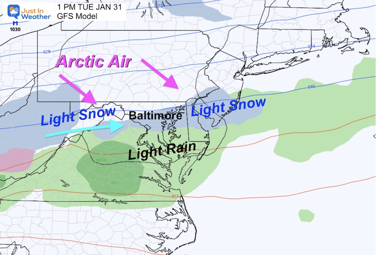
GFS Model
This is a new development… Our American Model is increasing the odds of light snow as well.
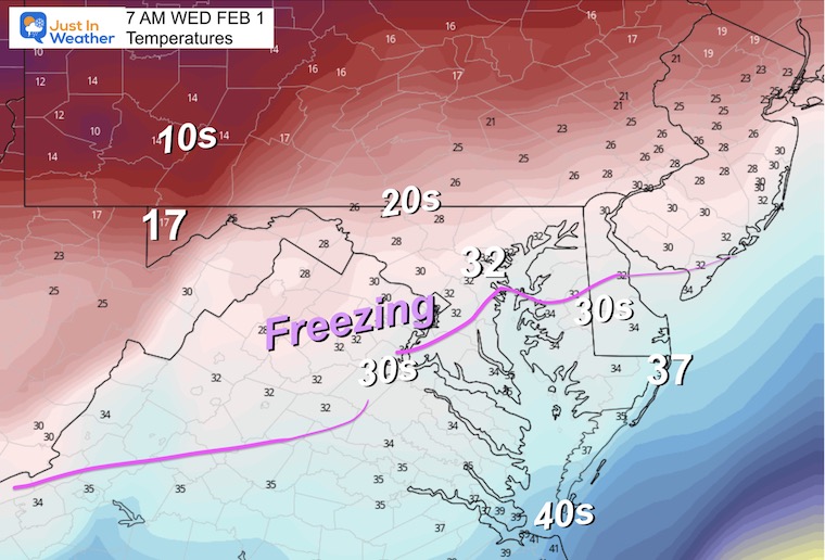
Wednesday Morning Temperatures
This is my concern for this mini event… Temps drop to near or below freezing. Wet pavement may turn icy for this commute. It is worth watching.
Take Away
I keep asking that you keep an open mind as computer model guidance often has trouble with these arctic air masses.
It looks like light snow or sleet is more likely on Tuesday. We have not gotten into Wednesday yet, and I will address that in my next report.
NOTE:
The core of the arctic air will arrive this weekend. Saturday is expected to remain in the 20s for much of our region.
FITF – Faith in the Flakes
Latest Measurable Snow In Baltimore
Today Is 3rd Latest
- Feb 21 in 1973 (50 years ago)
- Feb 6 in 1914 (109 years ago)
- Jan 30 in 2023 (Today)
- Jan 25 in 1992 ( 31 years ago)
- Jan 25 in 1901 ( 122 years ago)
- Jan 23 in 1966 (57 years ago)
Also See:
Winter History: Low Snow And Late Starts
See my research based on Baltimore data since 1883.
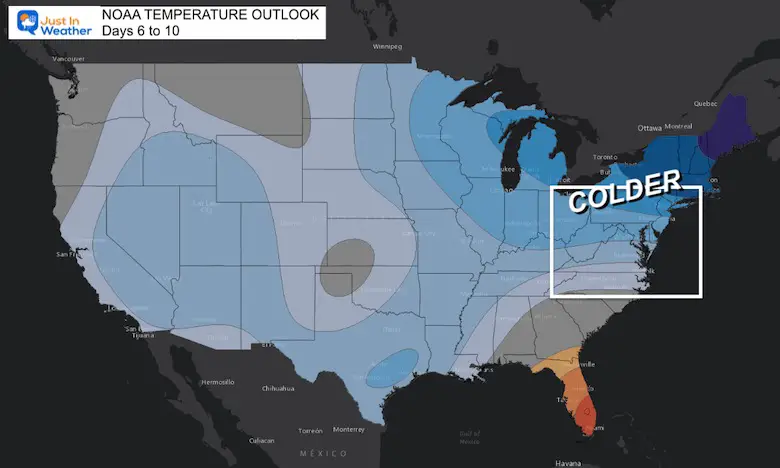
NOAA Outlook: Colder Start To February
Click here for the full report
Subscribe for eMail Alerts
Weather posts straight to your inbox
Sign up and be the first to know!
STEM Assemblies/In School Fields Trips Are Back
Click to see more and ‘Book’ a visit to your school
My Winter Outlook: Not A Typical La Niña!
I see many factors to support colder influence with multiple systems. Early and later in winter. Check it out.
Also See The Winter Outlook Series:
Winter Weather Folklore Top 20 And More Outlook Signals From Nature For Cold And Snow
Farmer’s Almanac Comparison
September Starts Meteorological Autumn: Weather Climate Stats For Maryland at Baltimore
Triple Dip La Niña Winter
https://justinweather.com/2022/09/09/winter-outlook-2023-la-nina-triple-dip-expectations/
CONNECTION TO WINTER?
If you want a snowy winter, this is what you might want to look for in the rest of the tropical season.
Rainbow Ice Cave In Mt. Rainier A Very Rare Find: Photos And Video
Wooly Bear Caterpillars
https://justinweather.com/2022/10/25/winter-weather-outlook-from-the-wooly-bear-caterpillar/
Persimmon Seeds
Click to see Top 20 and MORE
Winter Weather Folklore Top 20 And More Outlook Signals From Nature For Cold And Snow
Normals And Records: Maryland and Baltimore Climate History
Please share your thoughts, best weather pics/videos, or just keep in touch via social media
-
-
Facebook: Justin Berk, Meteorologist
-
Twitter: @JustinWeather
-
Instagram: justinweather
-


