NOAA Shows Colder Start To February And La Niña May Be Ending Soon
January 27, 2023
Saturday Afternoon Update
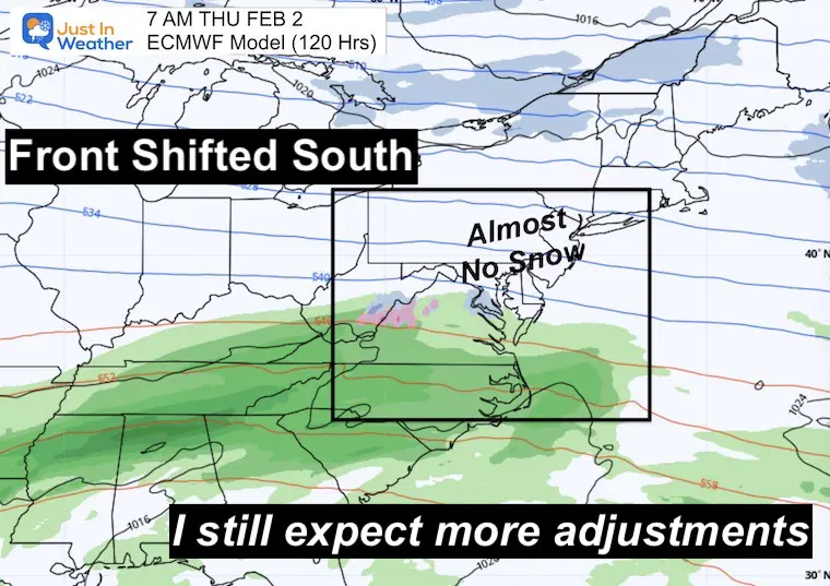
This latest Temperature Outlook update from NOAA has much of the Eastern US Colder for the Day 6 to 10 range. This takes us through the first week of February. This is a bit of a contradiction to their prior longer range outlook, but helps to highlight my purpose for this post. I continue to see computer projections change for an expected storm with each new model plot. The atmosphere is set up for winter weather, but the specifics are not easy to pin down.
NOAA Temperature Outlook
This applies to February 3 through 7
If you have seen the NOAA report, they also had a bump of warming for our region in the Day 10 to 14 range. I am not showing that because I continue to have low confidence in the model guidance.. which is also the basis for this NOAA outlook.
Translating Temperatures
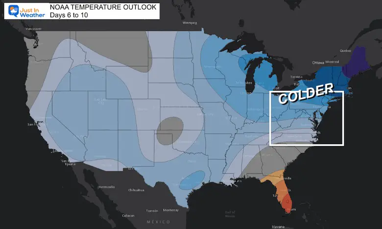
If we use Baltimore’s BWI for example, here is the temperature outlook from the GFS Model. Both were generated Saturday morning, January 28. They are VERY DIFFERENT!
The Deterministic is one solution using the highest resolution and computer power. That sounds great, but it can have flaws initializing or prioritizing some small elements over other… leading to errors farther out in time.
The Ensemble is a combination of multipole different formulas or solutions. This can be more valid blending and smoothing out the outliers for a more agreeable result.
Check out just temperature spread here!
Deterministic Forecast Temperatures
This shows our colder air mass next week, projecting high temps below average (43ºF). This is followed by a big bump to the 60s around Feb 10 and 11.
Keep scrolling…
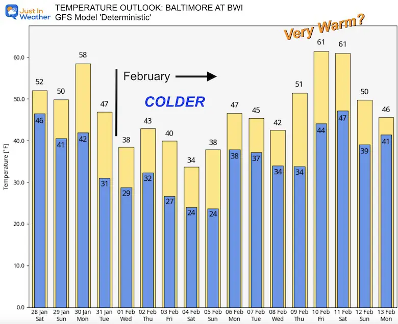
Ensemble Forecast Temperatures
This shows our colder air mass next week, projecting high temps below average as well. Then a little bump, but returning to near average in the middle of February.
With all the calculus and physics we have learned to apply to the atmosphere, we are still limited by the Chaos Theory. Weather is a chaotic system with many small variables. So if one is not accounted for early on, the results farther out in time can be very wrong. So each update as we get closer can change.
We see this often with the computer model guidance for storms as well. That is why I do not like to show storm plots more than one week way.
Mid Week Storm Plots
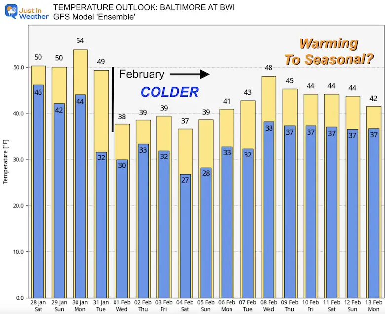
If you saw my post two days ago, it looked like a very active set up with snow for the Mid Atlantic mid week then a larger storm next weekend. I just want to focus on that first one as the results have changed.
Note: I did write on the prior maps that I expected an adjustment and we sure did!
Thursday Morning Weather Event?
European ECMWF Model
In the morning product, this seems to have lost the snow, suppressing the frontal boundary and rain to the south.
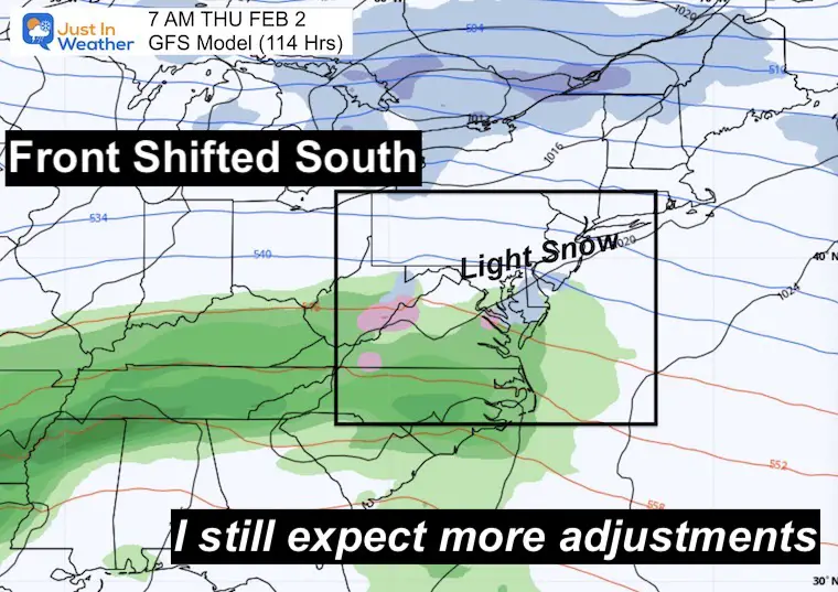
GFS Model
In the morning product, this had the snow/mix firmly in place.
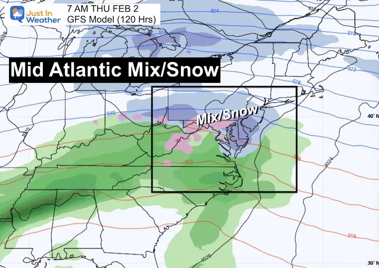
In the afternoon product (just 6 hours later) the storm seemed to fade and shift south like the ECMWF.
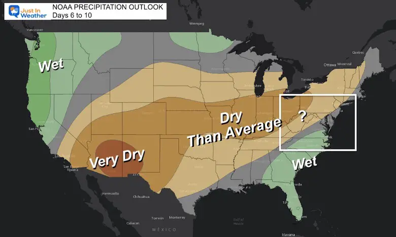
NOAA Precipitation Outlook
Considering the maps above, we can see the influence on this outlook. I still question the model reliability.
Take Away
There has been some serious issues with mid range forecasting of these models. Not only this winter, we had the problem last winter.
One common error I am waiting for: Storms and fronts tend to shift back north as we get closer. If that is the case again, we may see this event show back up on the Sunday or Monday plots.
As for the warm up for the following week, I am not sure we can rule out winter yet. Not only should we maintain caution and low confidence in longer range forecasting… There are still global patterns that support another disruption of the Polar Vortex. That is the push we need to surge colder air our way.
Repeating This Message From Dr. Cohen:
He expects the Polar Vortex to ‘stretch’ a second time in February. That would mean the GFS Model Temperature Outlooks above are missing it.
Every world class athlete knows that to perform at the highest levels you need to stretch & so it seems with the #PolarVortex (PV). One PV stretch ongoing, delivering #cold & #snow to North America & models increasingly suggest yet another stretched PV for second week of February pic.twitter.com/g4fu614Lyq
— Judah Cohen (@judah47) January 27, 2023
La Niña Is Weakening
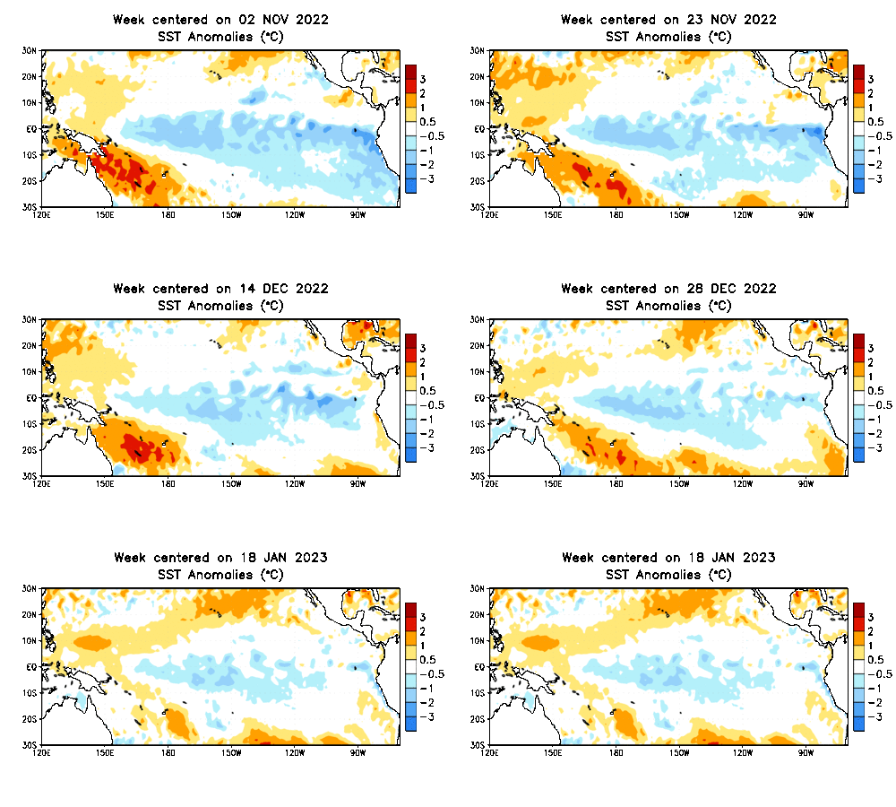
This is the Sea Surface Temperature Anomaly
Nov 2 2022 to Jan 18 2023
The blue is the region of below normal tropical water temperatures in the Pacific along the equator. That area is shrinking, suggesting the ending of this La Niña.
La Niña Update:
This is directly from from the Columbia Climate School
- In mid-January 2023, sea surface temperatures in the central-eastern equatorial Pacific remain below-average. Key oceanic and atmospheric variables have remained consistent with La Niña conditions, though there are indications that this is weakening.
- A CPC La Niña Advisory still remains in place for January 2023.
- The majority of models (19 out of 23) in the IRI ENSO prediction plume predict SSTs to transition from the level of a La Niña to ENSO-neutral state during Feb-Apr, 2023.
Once Again:
The end of winter is more favorable for our weather pattern as the Tropical Pacific should end the Triple Dip La Niña and go neutral.
This is what I reported back in early December: Click here for that report
Latest Measurable Snow In Baltimore
Today Is 3rd Latest
- Feb 21 in 1973 (50 years ago)
- Feb 6 in 1914 (109 years ago)
- Jan 28 in 2023 (Today)
- Jan 25 in 1992 ( 31 years ago)
- Jan 25 in 1901 ( 122 years ago)
- Jan 23 in 1966 (57 years ago)
Also See:
Winter History: Low Snow And Late Starts
See my research based on Baltimore data since 1883.
Subscribe for eMail Alerts
Weather posts straight to your inbox
Sign up and be the first to know!

STEM Assemblies/In School Fields Trips Are Back
Click to see more and ‘Book’ a visit to your school
My Winter Outlook: Not A Typical La Niña!
I see many factors to support colder influence with multiple systems. Early and later in winter. Check it out.
October 27 Nor’easter Recap Still Breezy Then Next Storm Friday
Also See The Winter Outlook Series:
October 27 Nor’easter Recap Still Breezy Then Next Storm Friday
Farmer’s Almanac Comparison
September Starts Meteorological Autumn: Weather Climate Stats For Maryland at Baltimore
Triple Dip La Niña Winter
CONNECTION TO WINTER?
If you want a snowy winter, this is what you might want to look for in the rest of the tropical season.
Rainbow Ice Cave In Mt. Rainier A Very Rare Find: Photos And Video
Wooly Bear Caterpillars
https://justinweather.com/2022/10/25/winter-weather-outlook-from-the-wooly-bear-caterpillar/
Persimmon Seeds
Click to see Top 20 and MORE
Winter Weather Folklore Top 20 And More Outlook Signals From Nature For Cold And Snow
Normals And Records: Maryland and Baltimore Climate History
Please share your thoughts, best weather pics/videos, or just keep in touch via social media
-
-
Facebook: Justin Berk, Meteorologist
-
Twitter: @JustinWeather
-
Instagram: justinweather
-


