High Wind Report Very Cold Ravens Game And Christmas Plus Hint Of Snow Next Week
December 23
Friday Evening Update
After all the talk of the Bomb Cyclone and rapidly falling temps, the focus was on the end as snow and possible flash freeze. While some of that freeze happened, it was minimal. The wind did meet and exceed expectations. Trees have fallen in many areas, and the result was closed roads and power outages. It is with profound sadness that I share the news it turned deadly in Frederick County.
I also will address when the winds will ease, the very cold weather for the Ravens game, Christmas morning, and perhaps some light snow early next week. I’ll explain.
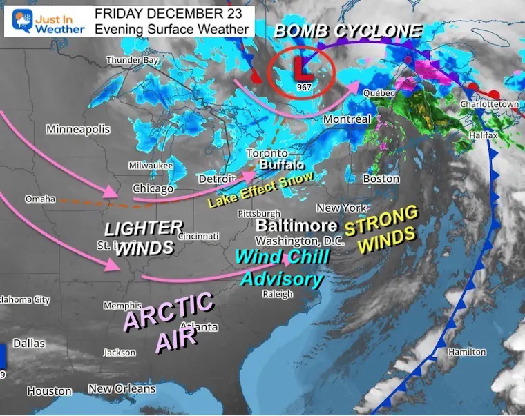
Friday Evening Surface Weather
That Bomb Cyclone has bottomed out at 967 mb. That is actually equivalent to the pressure of a Category 2 Hurricane. So, no wonder it has been a wind machine.
Much of our area is under a Wind Chill Advisory until 10 AM Saturday. A Wind Chill Warning in western Maryland until 1 PM Saturday.
The good news is that the winds will ease a bit tomorrow, but the coldest air will be settling in to counter the frigid feel.
Arctic Air has pushed all the way to the Gulf Coast and Florida!
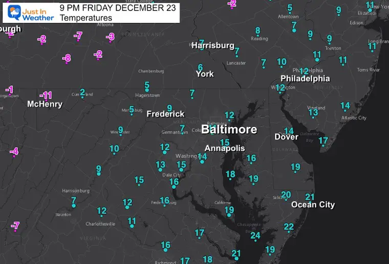
Conditions at 9 PM
I know there were doubters, but it really did get this cold! We have more to go overnight.
Temperatures
Yes, that is an actual temperature of -11ºF in McHenry, with Baltimore at +11ºF.
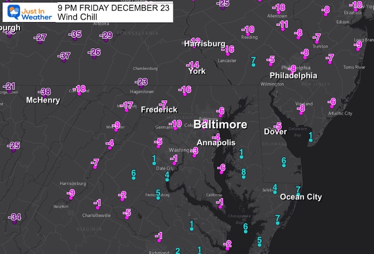
Wind Chill
McHenry wind chill was -38ºF validating the forecast, while the Baltimore area ranges from -5ºF to -10ºF.
Lake Effect Snow
Buffalo, NY is in for another epic event! This one may produce another 3 to 4 FEET! Check out the Blizzard and Zero Visibility conditions they posted today:
So what does “zero mile” visibility look like? Well, here’s a spectacular view of our parking lot near the airport. Yes, there are cars parked just a few feet away.
We don’t even want to be parked in it, you *definitely* don’t want to be driving in it. Seriously. https://t.co/ikpMJTnoU7 pic.twitter.com/px5jmVFLIe
— NWS Buffalo (@NWSBUFFALO) December 23, 2022
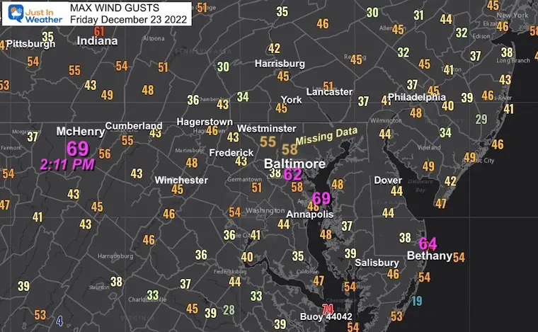
Local Max Wind Gusts
This is a map of the top wind gusts from area reporting stations around the region. Below is a list with even higher numbers across Maryland.
- 69 mph was the highest in Garrett County (mountains).
- 62 mph at BWI in Baltimore at 12:43 PM
- 64 mph was the highest along the coast in Bethany Beach, DE.
- 45 mph to 58 mph was the average across much of the region.
Westminster MD Wind Damage
This photo taken by Long & Foster shows part of a shopping center brick wall that collapsed onto a car. The top wind was nearby at 55 mph.

Deadly Result In Frederick County
A man was killed while driving on Rt 77 west of Thurmont. See that story in the Frederick News-Post.
Top Wind Gust List (From NWS Sterling VA Spotters)
Weather Forecast Details BELOW THE LIST
…District of Columbia…
Washington 1 WSW 53 1003 AM 12/23 Trained Spotter
GWU Mount Vernon Cam 49 1240 PM 12/23 MESOWEST
MARYLAND
…Allegany County...
- Md-135 At Salt Dome 56 924 AM 12/23 MESOWEST
- I-68 Eb At Street Ro 52 745 AM 12/23 MESOWEST
- I-68 At Savage Mt 51 935 AM 12/23 MESOWEST
- Md-51 At Oldtown Sal 50 1139 AM 12/23 MESOWEST
…Anne Arundel County…
- BWI Marshall Airport 62 1243 PM 12/23 ASOS
- Sandy Point 60 1038 AM 12/23 WXFLOW
- I-97 At Md-100 55 1229 PM 12/23 MESOWEST
- Glen Burnie 49 116 PM 12/23 CWOP
- Fort Meade 47 1138 AM 12/23 AWOS
- Annapolis Naval 47 1213 PM 12/23 ASOS
- Herring Bay 46 1110 AM 12/23 WXFLOW
BAY BRIDGE
- Bay Bridge S-9 E B 69 1119 AM 12/23 MESOWEST
- Bay Ridge 1 NNE 69 112 PM 12/23 NDBC
- Wpl Pier 31 62 1118 AM 12/23 MESOWEST
- Bay Bridge N-13 W B 56 1139 AM 12/23 MESOWEST
- Greenbury Point 49 1219 PM 12/23 WXFLOW
- Tolly Point 48 1114 AM 12/23 WXFLOW
- ; MD 48 1132 AM 12/23 WXFLOW
- Bay Ridge 2 SSE 46 1100 AM 12/23 NDBC
…ANZ533…
Cove Point LNG Pier; 51 924 AM 12/23 NOS-PORTS
…ANZ537…
Hull Neck 5 NNE 67 1248 PM 12/23 NDBC
Piney Point; MD 50 924 AM 12/23 NOS-PORTS
Cobb Point 48 850 AM 12/23 WXFLOW
…ANZ538…
Dundalk 3 SSW 54 1236 PM 12/23 NDBC
Francis Scott Key Br 53 124 PM 12/23 NOS-PORTS
…ANZ541…
Blackwalnut Harbor 50 1245 PM 12/23 WXFLOW
…ANZ542…
Solomons Island; MD 48 1112 AM 12/23 NOS-NWLON
…ANZ543…
Bishops Head; MD 51 1212 PM 12/23 NOS-NWLON
Crisfield 49 1212 PM 12/23 WXFLOW
Lower Hooper Island 47 109 PM 12/23 WXFLOW
…Baltimore County…
- Owings Mills 58 1045 AM 12/23 CWOP
- Md-43 At Md-150 51 1259 PM 12/23 MESOWEST
- Baltimore Martin 49 1057 AM 12/23 AWOS
- Baltimore/Lansdowne 49 1200 PM 12/23 CWOP
- Perry Hall 48 1153 AM 12/23 CWOP
- I-70 At I-695 46 1229 PM 12/23 MESOWEST
…Carroll County…
- Hampstead 55 1238 PM 12/23 CWOP
- Md-30 At Pa Line 50 1050 AM 12/23 MESOWEST
- Westminster 2 N 48 935 AM 12/23 AWOS
- Sykesville 48 1225 PM 12/23 CWOP
- Md-140 At Md-97 46 1241 PM 12/23 MESOWEST
...Charles County…
- Cuckold Creek 46 1211 PM 12/23 WXFLOW
…Frederick County…
- Wolfsville 1 S 58 1150 AM 12/23 Trained Spotter
- Ballenger Creek 2 NE 57 100 PM 12/23 MESOWEST
- Us-340 At Md-180 56 934 AM 12/23 MESOWEST
- Astrazeneca 53 930 AM 12/23 MESOWEST
- Sabillasville 3 SSW 52 909 AM 12/23 AWOS
- Thurmont 49 1105 AM 12/23 CWOP
- Us-15 At Md-140 46 950 AM 12/23 MESOWEST
…Garrett County…
- I-68 At Us 219 63 748 AM 12/23 MESOWEST
- I-68 at WV Line 50 724 AM 12/23 MESOWEST
- Garrett County Airpo 48 1255 PM 12/23 AWOS
…Harford County…
- Jarrettsville 49 1050 AM 12/23 CWOP
…Howard County…
- Us-29 @ Middle Patux 48 1030 AM 12/23 MESOWEST
- Elkridge 48 1214 PM 12/23 CWOP
…Montgomery County…
- Montgomery Co Airprk 52 1034 AM 12/23 AWOS
- Cabin John 50 1257 PM 12/23 CWOP
- I-270 At Md-109 46 1235 PM 12/23 MESOWEST
…Prince Georges County…
- Andrews AFB 51 1225 PM 12/23 AWOS
- Laurel 48 100 PM 12/23 CWOP
…St. Marys County…
- Point Lookout 55 929 AM 12/23 WXFLOW
- Patuxent River NAS 49 1201 PM 12/23 AWOS
…Washington County…
- Md-64 At Md-418 51 1249 PM 12/23 MESOWEST
- Hagerstown Rgnl Arpt 49 904 AM 12/23 ASOS
- Hagerstown 48 1145 AM 12/23 CWOP
- I-70 At Fred-Wash Co 46 944 AM 12/23 MESOWEST
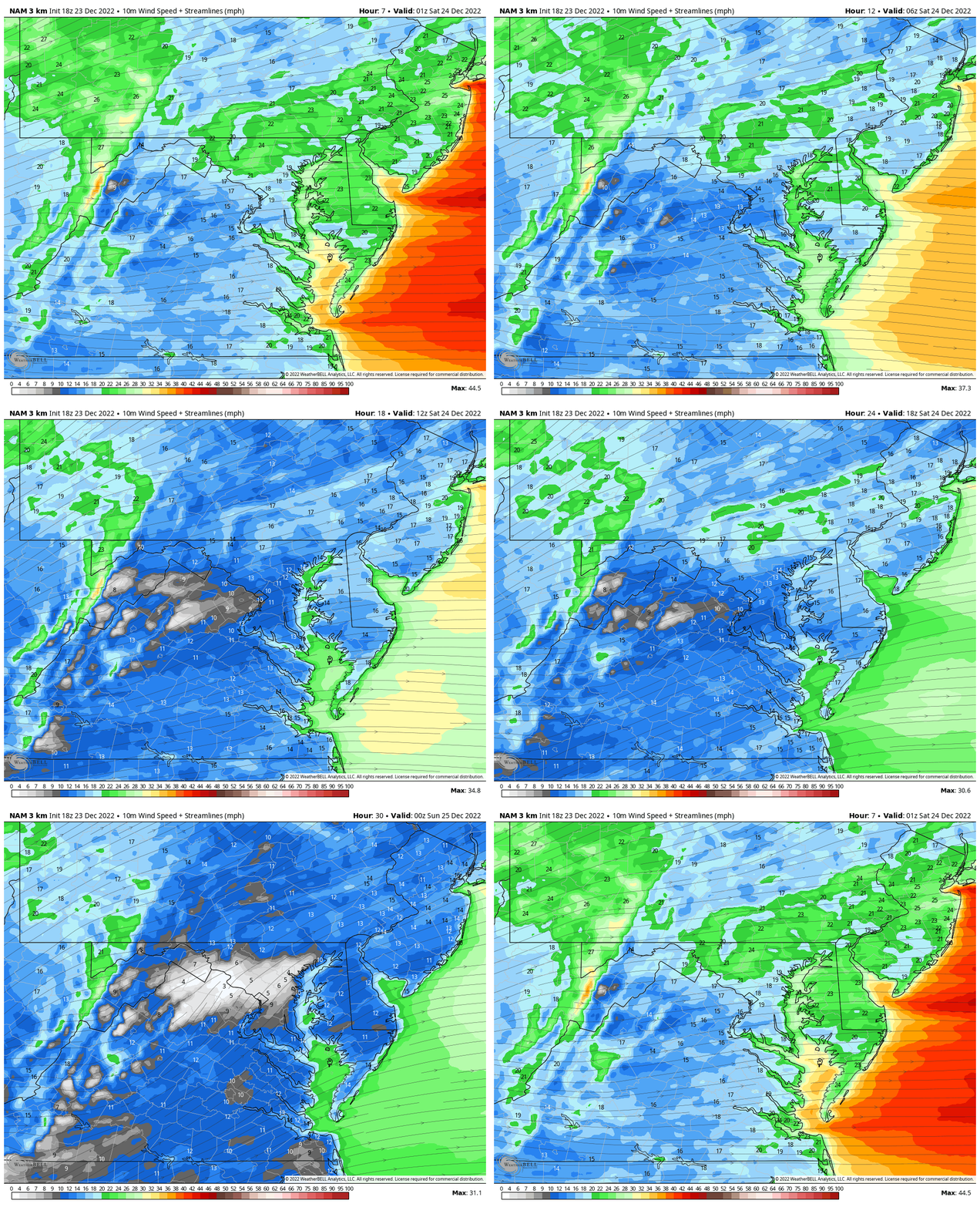
Wind Forecast Animation
8 PM Friday to 8 PM Sunday
You may not be able read the numbers, but I am sure the colors help show the easing of the winds Saturday afternoon and evening.
Saturday Weather
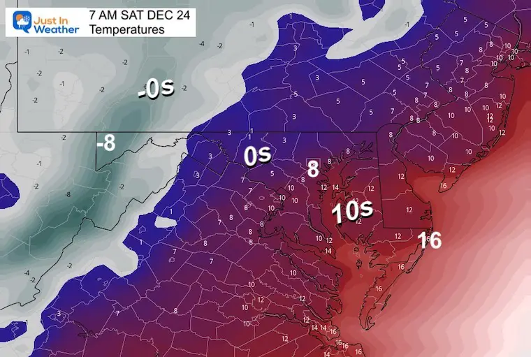
Morning Temperatures
These are actual expected readings on area thermometers.
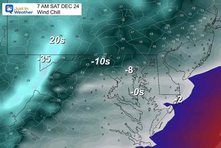
Morning Wind Chill
Winds will still be gusty and a factor to be painful!
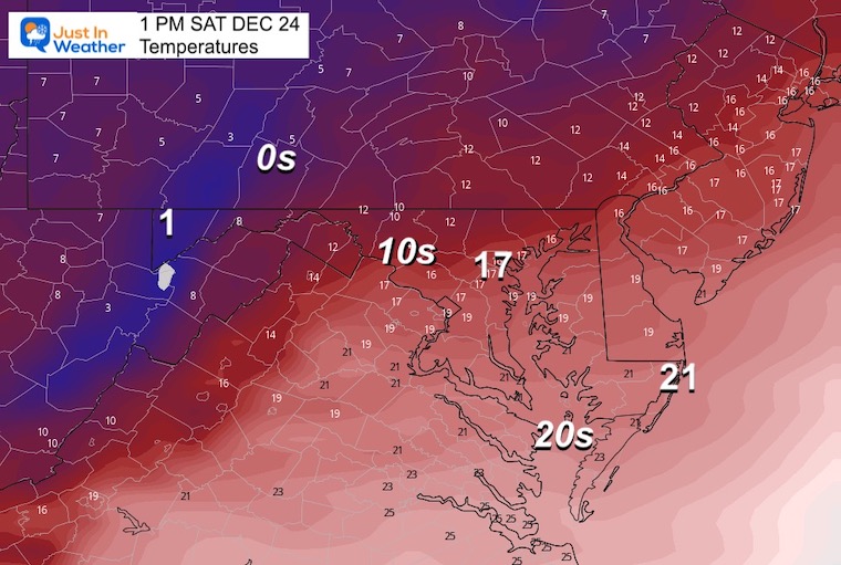
Afternoon (1PM Ravens Game Time)
It’s going to be a VERY COLD GAME
Temperatures
I believe it may be a little higher than this forecast, but even if the lower 20s are reached, it won’t feel much better.
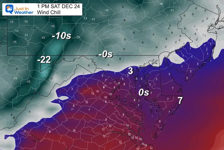
Wind Chill
It will be painful to be outside for a few hours for sure, but the wind will be less intense. It will not take much to knock it down to the single digits or colder.
Christmas Sunday
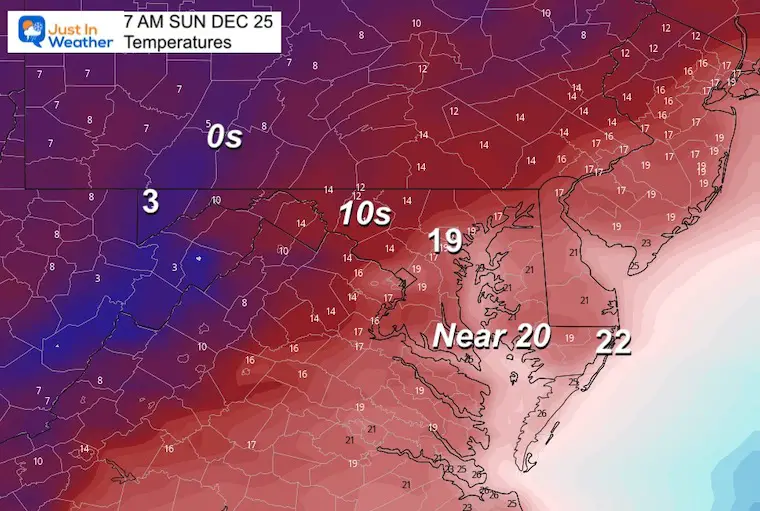
Morning Temperatures
Nearly the same readings as the Saturday afternoon. The improvement is NOT GETTING COLDER.
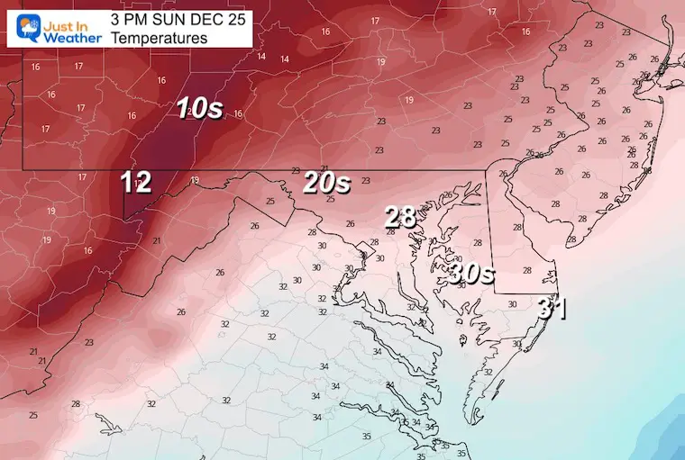
Afternoon Temperatures
Warming into the 20s for most central areas.
Can We Get Any Snow From This?
Well, I believe often in these arctic patterns little clippers get missed by the models, but bring us something before the warm up. I am also of the mindset that if the model don’t do much with this now, it may actually have a better chance. I’m not cynical!
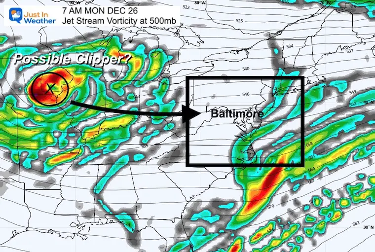
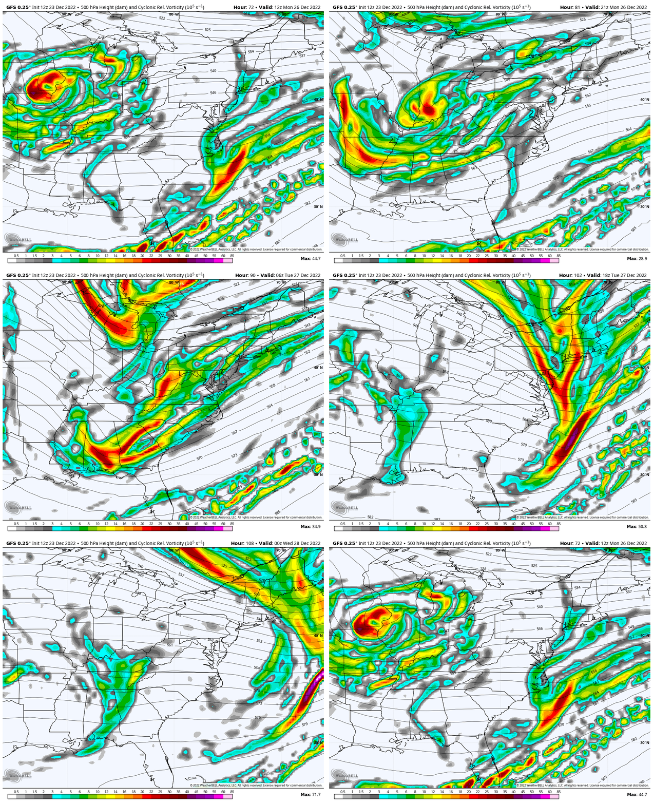
Jet Stream Vorticity
Monday Morning
Watching this ‘spin’ aloft at around 18,000 Ft aloft we can see energy help boost small systems to form. I’ve highlighted the Vort Max and possible Clipper (fast moving small system).
Animation: Monday Morning to Tuesday Evening
We can see the energy race quickly to the east coast.
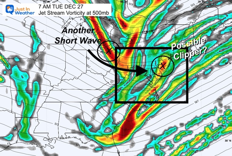
Snapshot Tuesday Morning
The initial Vort Max swings through and off the coast, with a noticeable trough in the Jet Stream to pivot through behind it.
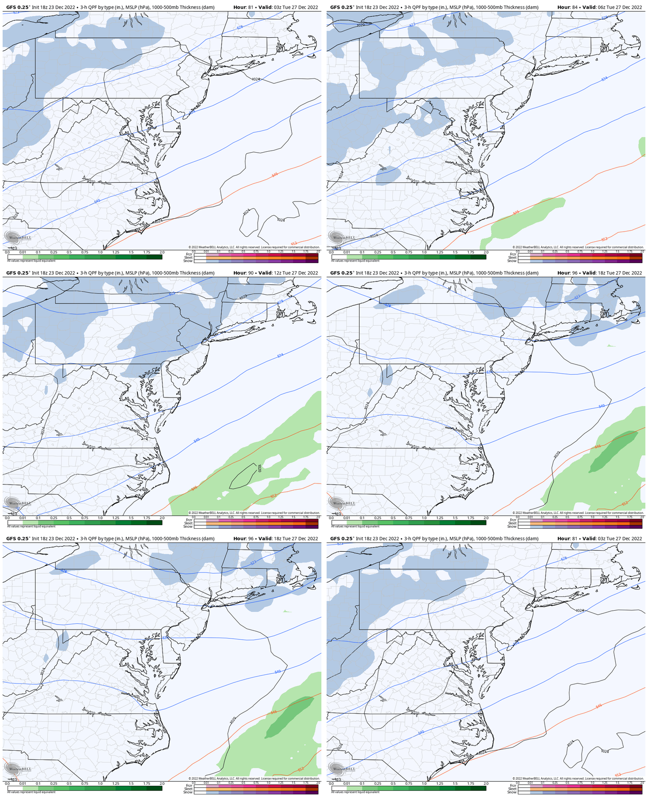
GFS Model Animation
Here we see a ‘hint’ of light snow Monday night to Tuesday Morning.
I am not promising much, but at least flurries or snow showers have been in my 7 Day forecast for a few runs because of this wave. It’s the only thing I see for the next 10 days.
I’ll be back with a full forecast in my morning weather report on Saturday. See you then.
Faith in the Flakes Gear
What is Faith in the Flakes?
It began with my son in 2009
October 27 Nor’easter Recap Still Breezy Then Next Storm Friday
SNOWSTIX – Available Now
STEM Assemblies/In School Fields Trips Are Back
Click to see more and ‘Book’ a visit to your school
My Winter Outlook: Not A Typical La Niña!
I see many factors to support colder influence with multiple systems. Early and later in winter. Check it out.
October 27 Nor’easter Recap Still Breezy Then Next Storm Friday
Also See The Winter Outlook Series:
October 27 Nor’easter Recap Still Breezy Then Next Storm Friday
Farmer’s Almanac Comparison
September Starts Meteorological Autumn: Weather Climate Stats For Maryland at Baltimore
Triple Dip La Niña Winter
CONNECTION TO WINTER?
If you want a snowy winter, this is what you might want to look for in the rest of the tropical season. (You might be seeing a lot of commercial snow removal people out this Winter).
Rainbow Ice Cave In Mt. Rainier A Very Rare Find: Photos And Video
Wooly Bear Caterpillars
https://justinweather.com/2022/10/25/winter-weather-outlook-from-the-wooly-bear-caterpillar/
Persimmon Seeds
Click to see Top 20 and MORE
Winter Weather Folklore Top 20 And More Outlook Signals From Nature For Cold And Snow
Normals And Records: Maryland and Baltimore Climate History
Please share your thoughts, best weather pics/videos, or just keep in touch via social media
-
Facebook: Justin Berk, Meteorologist
-
Twitter: @JustinWeather
-
Instagram: justinweather


