Explaining The Bomb Cyclone On Display And Timing Trend For Flash Freeze
December 20 2022
Tuesday Mid Day Update
Weather forecasting has always been a challenge, especially with the many elements that make a winter storm. I never intend to point fingers, but there has been sensational weather coverage on TV (yes, I worked on local TV news for 20 years) and social media. Terms like Polar Vortex are real meteorological phenomena but have been used exhaustively for headlines.
So here we are leading up to the Christmas Holiday, and the winter storm brings up two more terms that I need to use but feel obligated to explain: Bomb Cyclone and Flash Freeze.
Quick Take:
Timing is still a factor, and the faster trend I’ve been pointing out for months may be in play. This could lead to more frozen stuff at the onset in the mountains and possibly as close as Frederick and Carroll counties Thursday morning. That is if it arrives before 8 or 9 AM. Then on Friday, the freeze potential will be in ‘central’ areas midday Friday. I’ll explain below, and please see my thoughts at the bottom of the forecast maps.
What is a Bomb Cyclone?
In short, a storm is low pressure, and a deeper storm has lower numbers of atmospheric pressure we measure in millibars (mb). When a storm gets stronger, the mb are lower numbers, which we say are ‘dropping’.
A Bomb Cyclone is defined as a storm dropping more than 24 mb in 24 hours, or more than 1 mb per hour for a day. I’ll show you how this applies below.
What is a Flash Freeze?
A Flash Freeze is when arctic air arrives and turns wet pavement to ice. We expect temperatures to drop midday on Friday. The challenge is if pavement will remain wet as the temps drop, to allow ice to form on roads. Or will the cold wind evaporate that wet pavement, drying it up before it has a chance to freeze? If this was early morning or in the evening, it is more likely. Even near the Winter Solstice, the midday and afternoon sun angle can counter some of the cooling effects with radiation on the pavement to keep it a little warmer. The challenge is on.
I always err on the side of caution, which is enhanced with holiday travel. It’s best to expect the icing, and if we don’t get it, that would be a gift.
Can we really get these? Let’s take a look
Bomb Cyclone Storm Animation:
ECMWF Model Thu 4 AM to Fri 7 PM
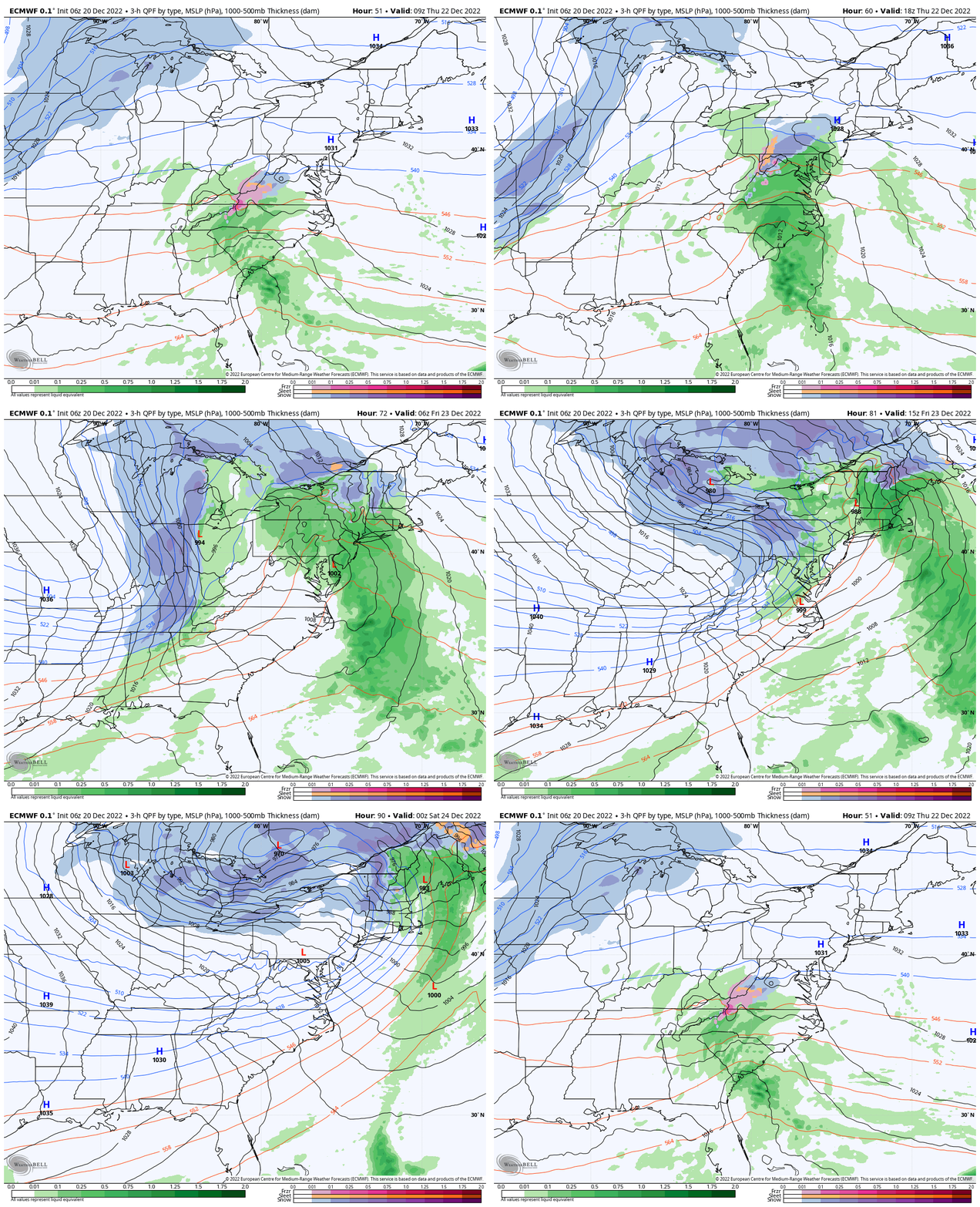
Key Timeframes
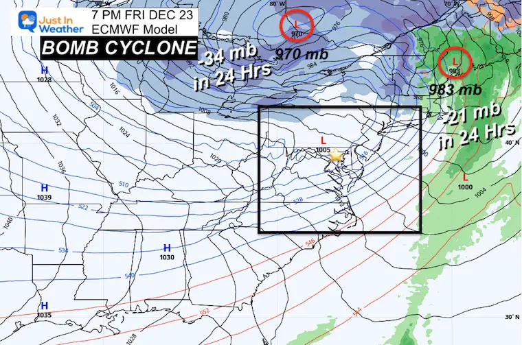
I’m starting with Thursday Night at 7 PM and comparing it to Friday Night at 7 PM.
Notice the Primary Low in Indiana starts at 1004 mb and ends in Canada with 970 mb. The drop of 34 mb in 24 hours qualifies this as a Bomb!
The coastal Low, which was the reason there WAS a suggestion for more snow locally, is not as strong/less dominant. But it is close to bombing out as well, going from 1004 mb to 983 mb, a drop of 21 mb in 24 hours.
The reason there is little to no snow for the East Coast is because the inland Low is going to be stronger and pump in warmer air. If the coastal Low were dominant, then colder air would have allowed more snow to take over in the cities.
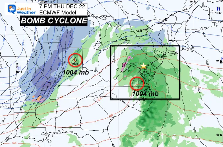
Thursday 7 PM
Both Low Pressure systems are projected to have a central pressure of 1004 mb. That’s the baseline as they are cranking up.
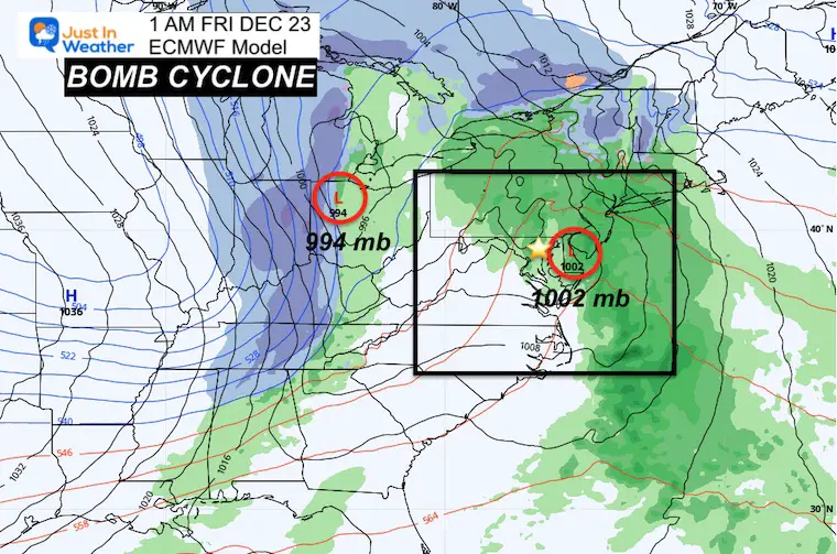
Friday 1 AM
Primary Low = 994 mb. A drop of 10 mb in 6 hours
Coastal Low = 1002 mb. A drop of 2 mb in 6 hours.
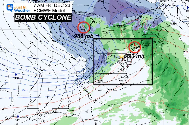
Friday 7 AM
Primary Low = 988 mb. A drop of 6 mb more in 6 hours
Coastal Low = 993 mb. A drop of 9 mb in 6 hours. It is trying…
Friday 1 PM
Primary Low = 974 mb. A drop of 12 mb more in 6 hours
Coastal Low = 989 mb. A drop of 4 mb in 6 hours. The energy available is being used up by the primary Low.

Friday 7 PM
Primary Low = 970 mb. A drop of 4 mb more in 6 hours, a total of 34 mb in 24 hours
Coastal Low = 983 mb. A drop of 9 mb in 6 hours. Still impressive, but not the main event. Final total drop of 21 mb in 24 hours.
Faster Timing:
Like many prior systems, if this arrives sooner it brings in two concerns:
- Starting Thursday with snow or icy mix inland. It would need to begin BEFORE 10 AM to have an impact on roads. Later will likely just be wet roads.
- Timing the arctic air and Flash Freeze Potential
Let’s Compare Thursday Arrival
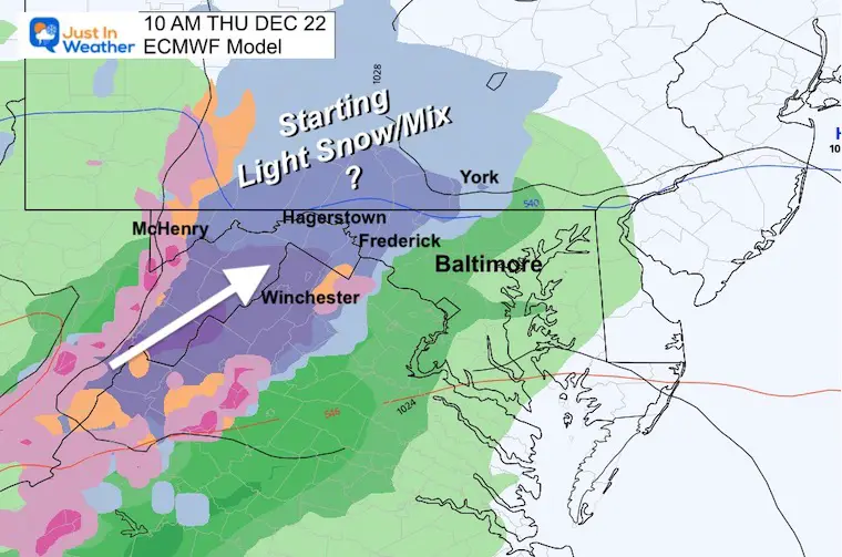
The ECMWF is FASTER than the GFS. This model brings in the snow and mix before sunrise in the mountains west of I-81, but could sneak into parts of Frederick and Carroll counties in Maryland.
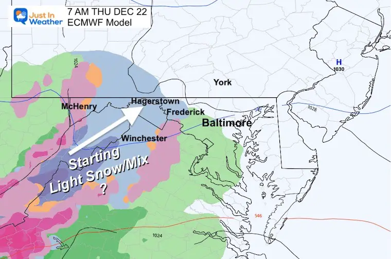
7 AM Thursday
ECMWF shows light snow reaching Frederick County. I-81 travel could be affected from Hagerstown southward to VA plus Skyline Drive area and west to West Virginia.
10 AM Thursday
The ECMWF shows steady snow now along the front range mountain near Frederick to York and west to I-81. If this gets going by 8 or 9 AM, then this may be a road issue.
Metro Baltimore looks just wet.
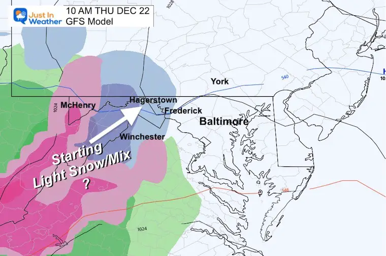
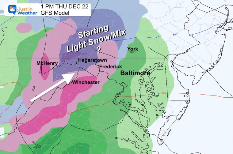
The GFS Model is slower but has snow reaching Hagerstown, Cumberland, and down south on I-81. An icy mix in the mountains of VA and WV should be considered very likely.
1 PM Thursday
The ECWMF at this time brings in the thaw sooner. The GFS shown here has a mix along the front range mountains near Frederick to York County, PA. I would consider travel concerns for:
- I-81, I-68 in MD
- Rt 30 in PA
- Penn Turnpike west of Harrisburg
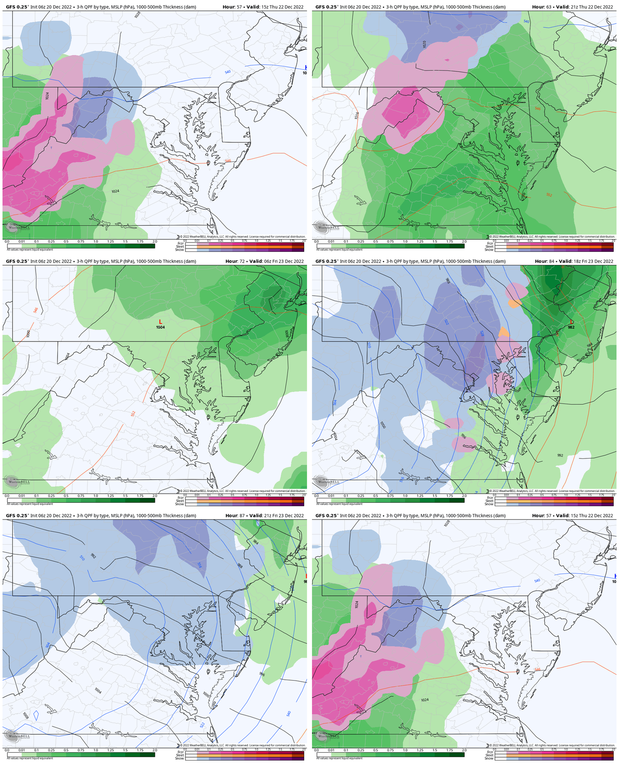
Storm Animation: GFS Model
10 AM Thursday to 4 PM Friday
I am showing this because it may match most of your weather apps. Also, it shows the worst-case scenario for Friday with back-end snow and a Flash Freeze. This is the slower model and ALSO puts more moisture behind the arctic front. That would be the Friday Flash Freeze concern.
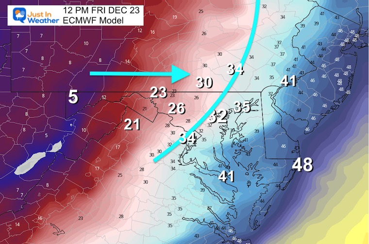
Timing The Freezing Line
Noon Friday
ECMWF Model
This is the faster solution: The storm departs sooner with less back-edge moisture. However, the deep freeze arrives sooner.
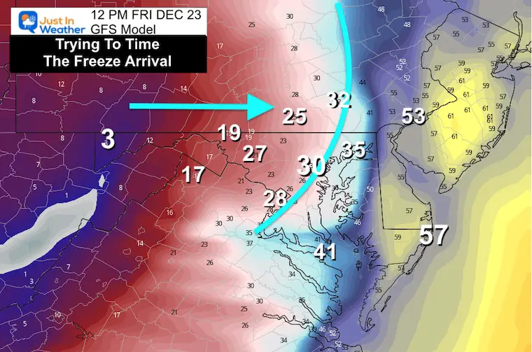
GFS Model
This may be a little slower and have more snow behind the front, but the cold air has also been trending earlier.
My Take:
This is still a moving target. Do not assume the forecast is final yet. So if you are driving west of the cities, please keep checking back for updates on timing and impact for BOTH Thursday and Friday.
If you are staying in central Maryland/Pennsylvania, then the bigger concern for you is the Flash Freeze potential on Friday. I will update any snow accumulations if needed. For now, just focus on the timing of the cold air and icing on roads midday.
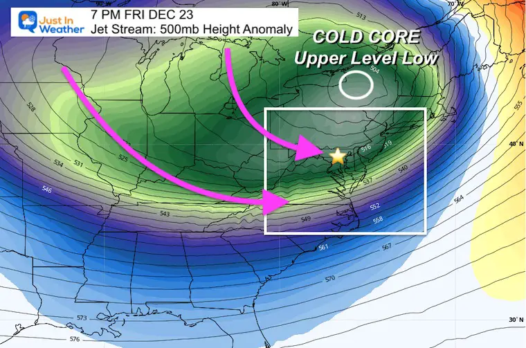
Jet Stream
The location of the Upper-Level Core Cold Low will be in New York State. This is an epic event, but the location to our north limits the snow influence for us… and maximizes it for New York and New England.
NWS Buffalo has called this an unusually memorable event.
TWEETS
Great Lakes Traveling
A powerful storm will impact the region heading into the holiday weekend. Here’s an overveiw of the potential weather hazards Thursday through Saturday night. pic.twitter.com/HqT8QtoRps
— NWS Buffalo (@NWSBUFFALO) December 19, 2022
Widespread Impact: We are just on the edge in Maryland
This map shows the areas of greatest impacts (combination of wind and snow) throughout the Lower Great Lakes Saturday morning. pic.twitter.com/6T7op0ob3E
— NWS Buffalo (@NWSBUFFALO) December 20, 2022
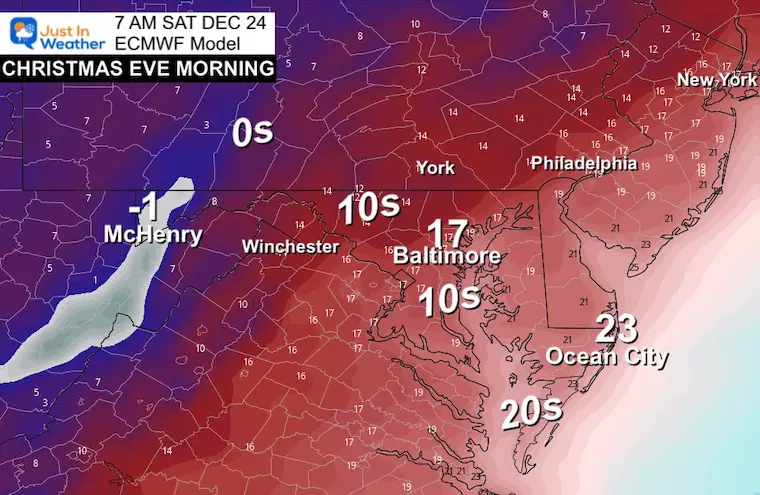
Christmas Weekend: VERY COLD
I am just showing Saturday Morning, but this is like to repeat for Christmas Day as well.
Baltimore reaches the mid Teens, with Ocean City and coastal areas in the Mid 20s.
7 Day Forecast
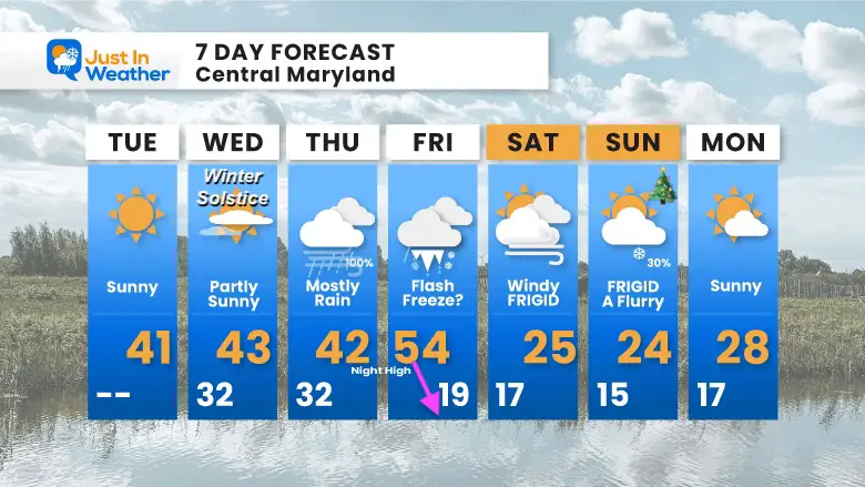
I wrote ‘mostly rain’ for Thursday, but this is for metro Baltimore. Let’s watch the icing potential for inland. I will have another update this evening.
Faith in the Flakes Gear
What is Faith in the Flakes?
It began with my son in 2009
October 27 Nor’easter Recap Still Breezy Then Next Storm Friday
SNOWSTIX – Available Now
STEM Assemblies/In School Fields Trips Are Back
Click to see more and ‘Book’ a visit to your school
My Winter Outlook: Not A Typical La Niña!
I see many factors to support colder influence with multiple systems. Early and later in winter. Check it out.
October 27 Nor’easter Recap Still Breezy Then Next Storm Friday
Also See The Winter Outlook Series:
October 27 Nor’easter Recap Still Breezy Then Next Storm Friday
Farmer’s Almanac Comparison
September Starts Meteorological Autumn: Weather Climate Stats For Maryland at Baltimore
Triple Dip La Niña Winter
CONNECTION TO WINTER?
If you want a snowy winter, this is what you might want to look for in the rest of the tropical season. (You might be seeing a lot of commercial snow removal people out this Winter).
Rainbow Ice Cave In Mt. Rainier A Very Rare Find: Photos And Video
Wooly Bear Caterpillars
https://justinweather.com/2022/10/25/winter-weather-outlook-from-the-wooly-bear-caterpillar/
Persimmon Seeds
Click to see Top 20 and MORE
Winter Weather Folklore Top 20 And More Outlook Signals From Nature For Cold And Snow
Normals And Records: Maryland and Baltimore Climate History
Please share your thoughts, best weather pics/videos, or just keep in touch via social media
-
Facebook: Justin Berk, Meteorologist
-
Twitter: @JustinWeather
-
Instagram: justinweather


