December 20 Cold Calm Before Holiday Winter Storm And Flash Freeze Friday
December 20 2022
Tuesday Morning Update
We start off cold and quiet with temperatures remaining below average. The blip of warm air will be in the middle of the storm ahead, ending with an arctic blast. It is becoming more obvious now how this storm will behave, we just need to refine the details of timing as that will be critical to the most impactful part: Flash Freeze Friday Then Bitter Cold Christmas.
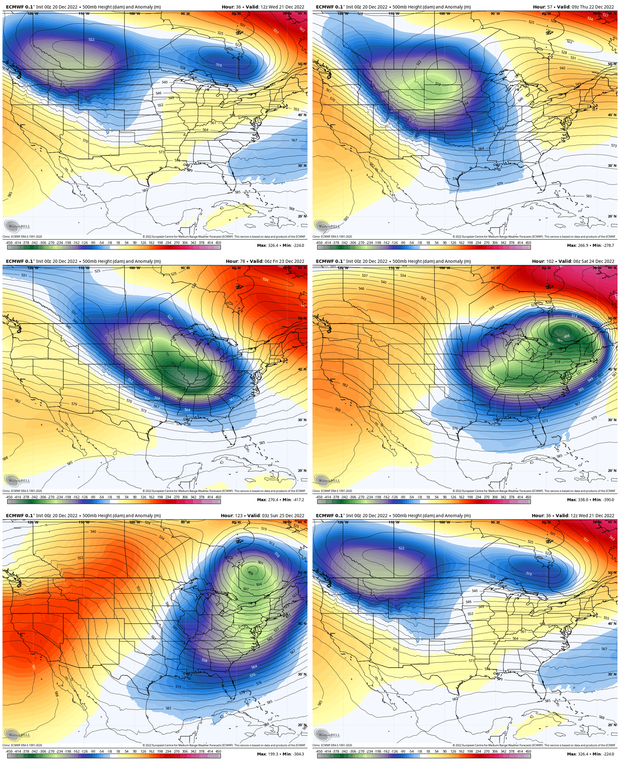
Jet Stream: Wednesday Morning To Christmas Morning
I want to emphasize Friday for a possible Flash Freeze. Arctic air will catch up to the end of the storm. It will end with sleet and snow, but may last anywhere from an hour to a few hours. The accumulation will be minimal, but keeping the roads wet as temps drop from the 50s to 20s brings the potential for a flash freeze! So timing the cold air will determine when that may happen.
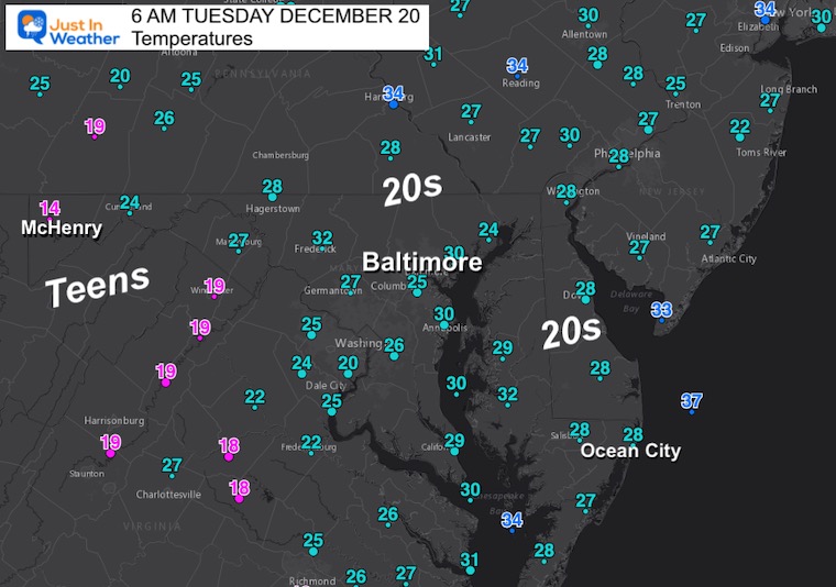
Morning Temperatures
The cold air in place is seasonal, but colder winds will hold the temps down this afternoon.
Headlines
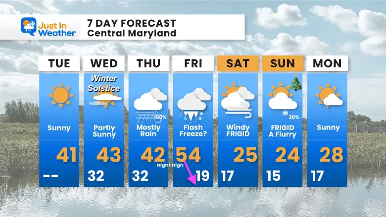
Today: Cold, Calm, and Dry!
Wednesday: Winter Solstice
Thursday: Rain likely after 10 AM
Friday: Arctic Air Arrives 10 AM to 1 PM
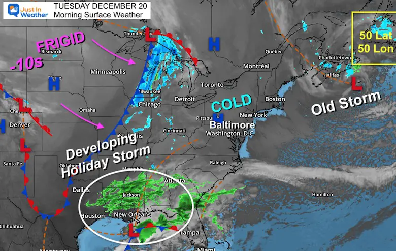
Morning Surface Weather
This wide view shows just a few of the ingredients of this storm. I am still watching this Old Storm off Eastern Canada. That 50 Lat/50 Lon location by Newfoundland is where it was supposed to close off and stall, holding the cold air and shifting the storm track. Well, it is still there this morning… I do not want to add false anticipation, I’m just watching how this behaves to affect the storm track and cold air available.
In the meantime, High Pressure will build in for a quiet day.
Arctic air already below zero in Montana and North Dakota!
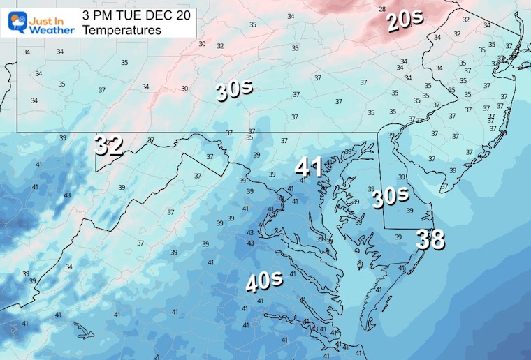
Afternoon Temperatures
Still colder than average.
Subscribe for eMail Alerts
Weather posts straight to your inbox
Sign up and be the first to know!
CLIMATE DATA
TODAY December 20
Normal Low in Baltimore: 29ºF
Record 6ºF in 1942
SNOW: 3.0” 1966
Normal High in Baltimore: 46ºF
Record 67ºF 1877
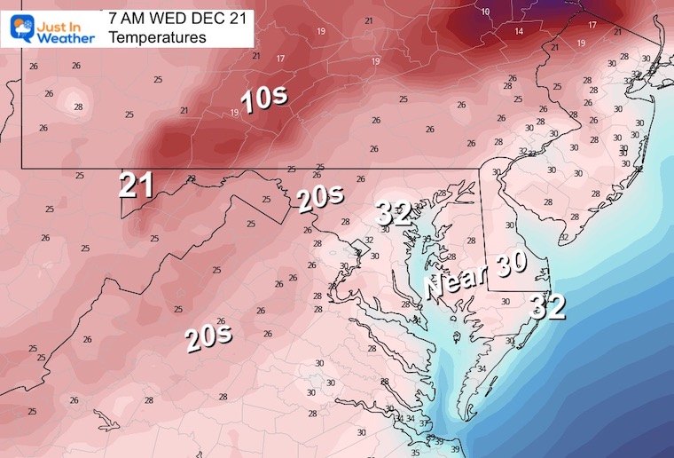
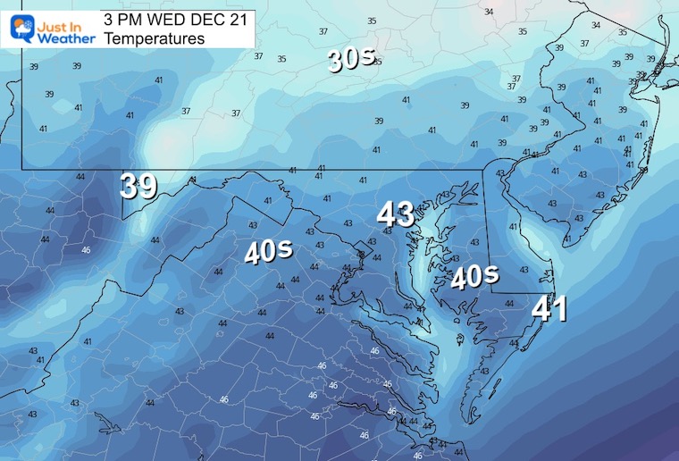
Wednesday Temperatures
Morning
Seasonably cold for much of our region.
Afternoon
Mostly sunny with high clouds arriving ahead of the storm.
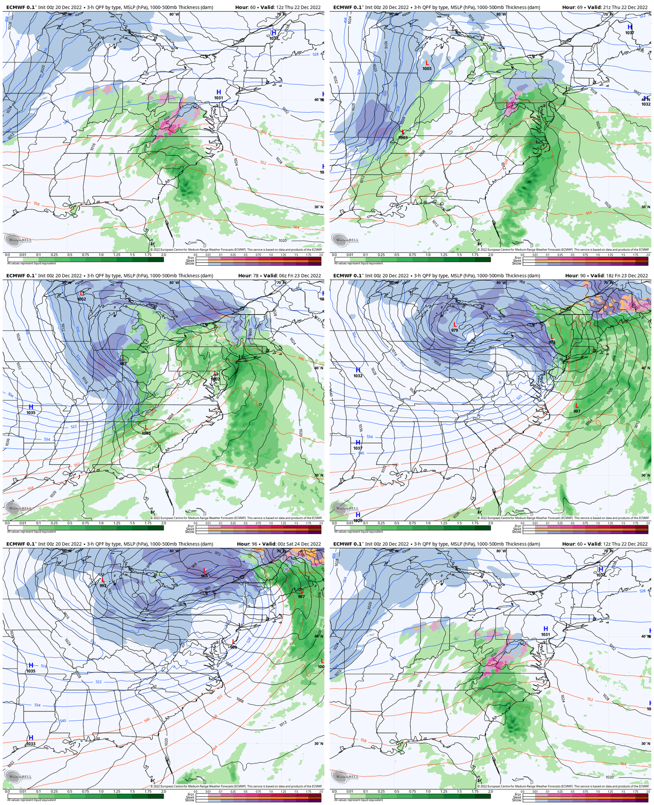
The BIG STORM (2-Days)
Computer Model Guidance From Monday Night
Thursday Morning To Friday Evening
Let’s plan for rain to arrive AFTER 10 AM, but a few hours of snow or mix west of Hagerstown.
Mostly rain and warming Thursday night to early Friday.
Blizzard Conditions likely near Chicago and Great Lakes can affect plane travel in other areas.
Mid Atlantic change to snow and maybe icing on the roads Friday late morning to afternoon. New England will not get the colder air until Friday evening.
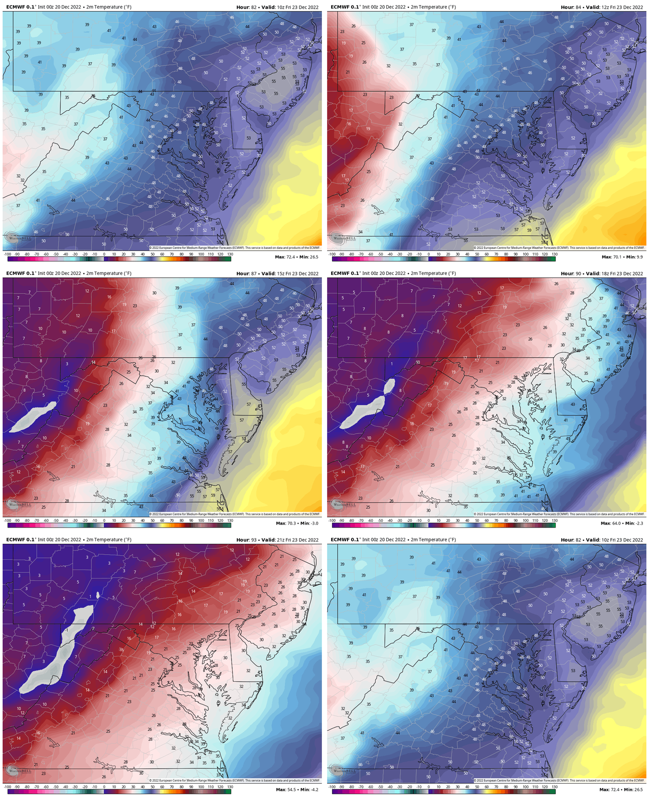
Temperatures: Flash Freeze Friday
6 AM to 4 PM
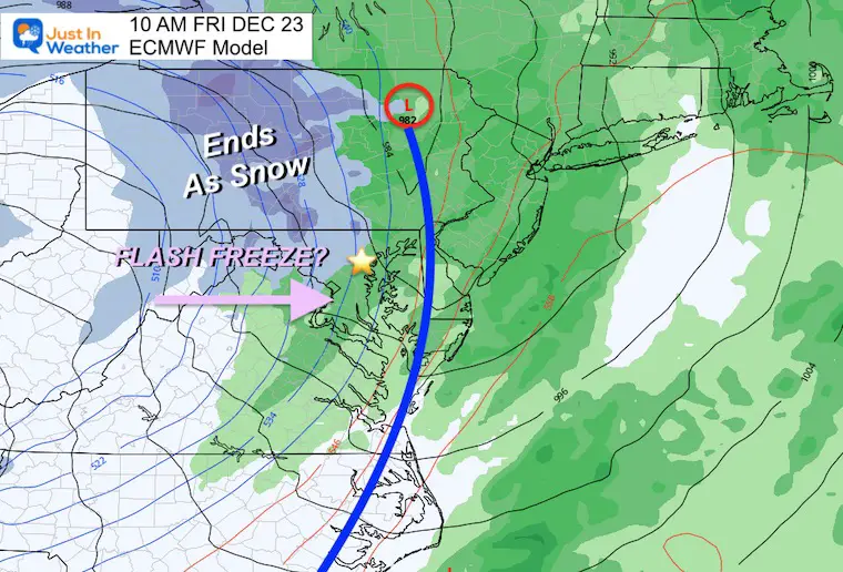
ECMWF Model
10 AM
This model also brings the arctic front in through Baltimore by late morning. The freezing temps will arrive 1 to 2 hours behind the front. With plenty of moisture left over, the wet ground will stay wet in time to freeze.
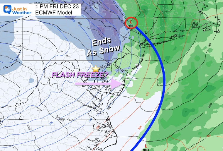
1 PM
Light snow showers or flurries will end early afternoon. The freezing temps arrive and continue to drop through the 20s allowing anything wet to freeze.
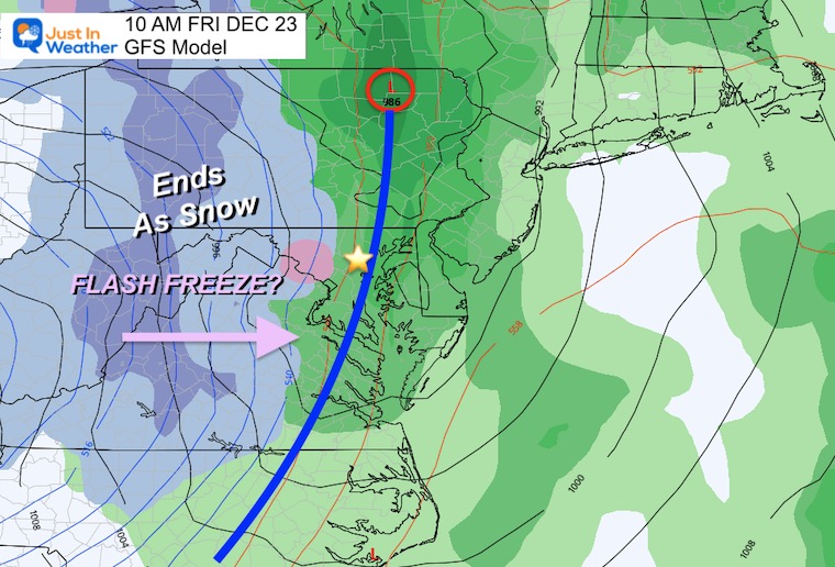
GFS Model
10 AM
This also brings the arctic front in through Baltimore by late morning. The freezing temps will arrive 1 to 2 hours behind the front. With plenty of moisture left over, the wet ground will stay wet in time to freeze.
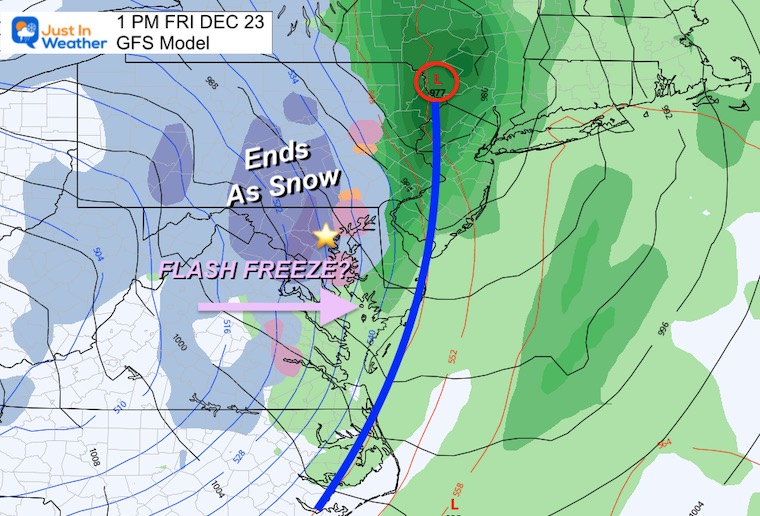
1 PM
This model keeps more moisture around and is trying to produce some accumulation, in addition to the drop into the 20s and flash freeze. This is one of the refining details I hope to get more clarity on with today’s computer guidance.
Saturday Morning- Christmas Eve Day will be FRIGID!
7 Day Forecast
Winter Solstice is Wednesday!
Most attention for Friday and timing the Flash Freeze. The information the models put out this morning will help us refine expectations. If there is any shift/blip or locking in on the the timing, we may notice it today.
Faith in the Flakes Gear
What is Faith in the Flakes?
It began with my son in 2009
October 27 Nor’easter Recap Still Breezy Then Next Storm Friday
SNOWSTIX – Available Now
STEM Assemblies/In School Fields Trips Are Back
Click to see more and ‘Book’ a visit to your school
My Winter Outlook: Not A Typical La Niña!
I see many factors to support colder influence with multiple systems. Early and later in winter. Check it out.
October 27 Nor’easter Recap Still Breezy Then Next Storm Friday
Also See The Winter Outlook Series:
October 27 Nor’easter Recap Still Breezy Then Next Storm Friday
Farmer’s Almanac Comparison
September Starts Meteorological Autumn: Weather Climate Stats For Maryland at Baltimore
Triple Dip La Niña Winter
CONNECTION TO WINTER?
If you want a snowy winter, this is what you might want to look for in the rest of the tropical season. (You might be seeing a lot of commercial snow removal people out this Winter).
Rainbow Ice Cave In Mt. Rainier A Very Rare Find: Photos And Video
Wooly Bear Caterpillars
https://justinweather.com/2022/10/25/winter-weather-outlook-from-the-wooly-bear-caterpillar/
Persimmon Seeds
Click to see Top 20 and MORE
Winter Weather Folklore Top 20 And More Outlook Signals From Nature For Cold And Snow
Normals And Records: Maryland and Baltimore Climate History
Please share your thoughts, best weather pics/videos, or just keep in touch via social media
-
Facebook: Justin Berk, Meteorologist
-
Twitter: @JustinWeather
-
Instagram: justinweather


