Tuesday, December 13 2022
Our first winter event of the season is expected to arrive on Thursday morning. In the previous days, I have highlighted that this is most likely to be a freezing rain, to rain event for most of our region. Then on Monday, the GFS went colder and added some snow to the mix. The local National Weather Service offices bit on that, perhaps because it is from the American-funded model, which just had an expensive upgrade.
Whatever the reason, we continue to examine multiple models and will try to come up with the best solution for what you may get. I say we, because you see my forecasts here, but other meteorologists and The National Weather Service have their expectations plotted as well. Some are similar, but not always the same.
Since I am expecting little snow and more icing, I felt this was a safe time to show the maps and explain the detail without too much misleading info. I want to explain what you are seeing or have seen others post.
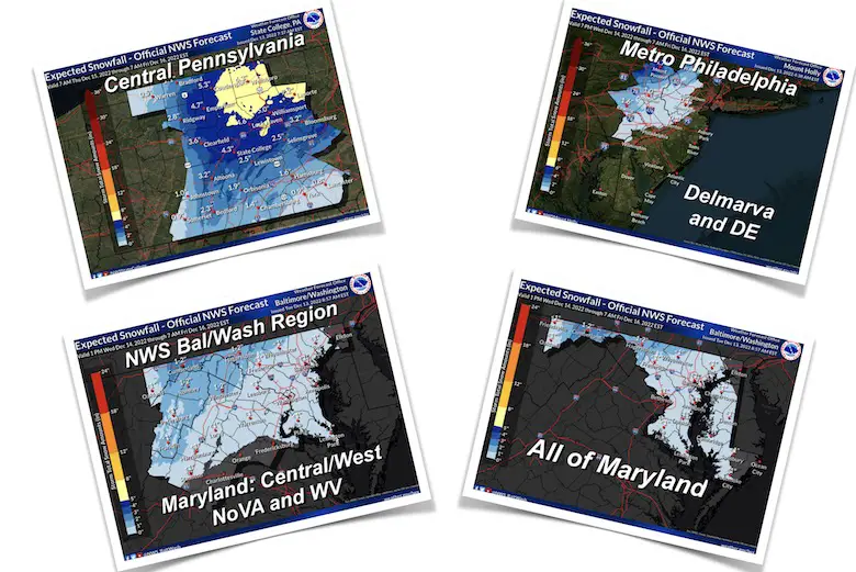
Let’s explore the Maryland maps so I can explain a few things. These forecasts are from Tuesday morning, Dec 13.
From National Weather Service in Sterling, VA
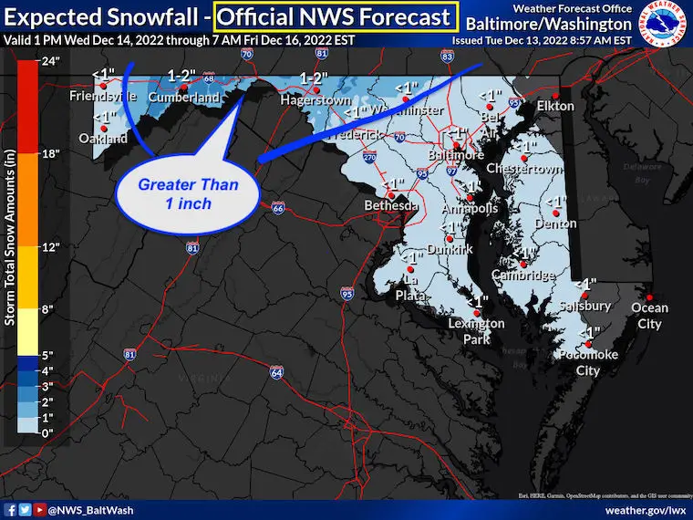
Official Snow Forecast
This shows a broad area for <1” UNDER ONE INCH
However, OVER 1 inch near Westminster, Frederick, Hagerstown, and Cumberland.
Please keep scrolling
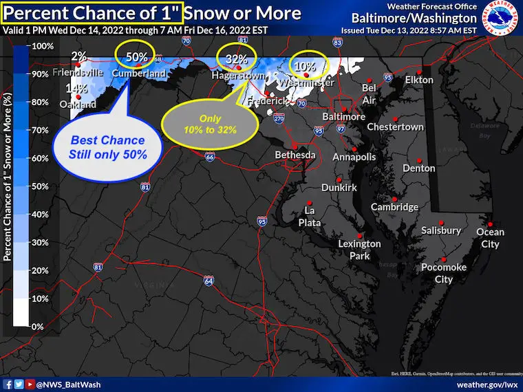
National Weather Service in Sterling, VA
Percent Chance Over 1”
This is where we look at that 1” snow forecast for Westminster, and on this map, it has only around a 10% chance to get there. Huh?
Hagerstown up to 32%
While Cumberland in the 1” to 2” forecast has a 50% chance.
These are hardly a promise and can be confusing.
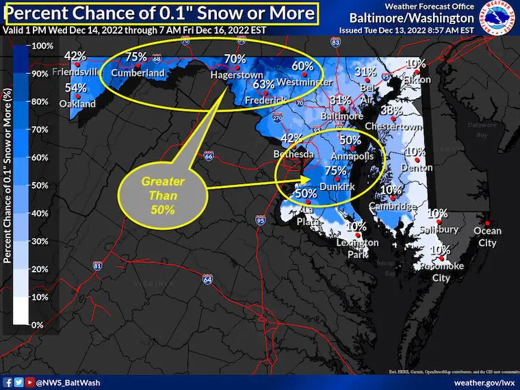
National Weather Service in Sterling, VA
Percent Chance Over 0.1” (a Trace)
This shows a much larger area with a coating of snow, which ironically is 50% in Annapolis and 75% in Dunkirk, but 31% from Baltimore to Bel Air. That may be a function of the arrival time and mixing with water air at moderate levels from the Chesapeake Bay.
Westminster, Frederick, and points west and north are more likely (from NWS) to get a coating of snow before the icing.
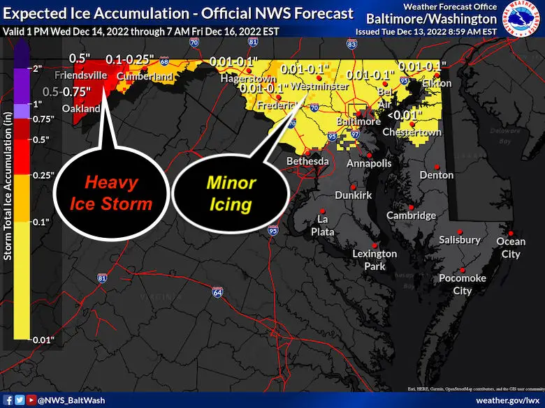
Speaking Of Ice: Based on Sleet and Freezing Rain
A broad area of up to 0.1” (a tenth of an inch). Not a full ice storm but a glaze that can affect traffic in the morning.
There will be a better chance of extensive ice problems and maybe tree/power line concerns between Cumberland, Frostburg, and Garrett County.
I will have a new update on the winter event this afternoon.
More Maps and Links
Out of respect, I have added National Weather Service winter maps to a page on my website you can easily access.
Also, I wanted to add links to regional offices for even more maps you can explore. They include:
Central Pennsylvania: From NWS State College
https://www.weather.gov/ctp/winter
Metro Philadelphia, NJ, and all of Delaware: From NWS Mount Holly, NJ
https://www.weather.gov/phi/winter
Most of Maryland Maryland, Northern Virginia, and parts of West Virginia: From NWS Sterling VA
https://www.weather.gov/lwx/winter
My Morning Forecast
October 27 Nor’easter Recap Still Breezy Then Next Storm Friday
Normals And Records: Maryland and Baltimore Climate History

Faith in the Flakes Gear

SNOWSTIX – Available Now

STEM Assemblies/In-School Fields Trips Are Back
Click to see more and ‘Book’ a visit to your school

My Winter Outlook: Not A Typical La Niña!
I see many factors to support colder influence with multiple systems. Early and later in winter. Check it out.
October 27 Nor’easter Recap Still Breezy Then Next Storm Friday
Also See The Winter Outlook Series:
October 27 Nor’easter Recap Still Breezy Then Next Storm Friday
Winter Outlook 2023 La Niña Triple Dip Expectations
Farmer’s Almanac Comparison
September Starts Meteorological Autumn: Weather Climate Stats For Maryland at Baltimore
Triple Dip La Niña Winter
Winter Outlook 2023 La Niña Triple Dip Expectations
CONNECTION TO WINTER?
If you want a snowy winter, this is what you might want to look for in the rest of the tropical season. (You might be seeing a lot of commercial snow removal people out this Winter).
Rainbow Ice Cave In Mt. Rainier A Very Rare Find: Photos And Video
Wooly Bear Caterpillars
https://justinweather.com/2022/10/25/winter-weather-outlook-from-the-wooly-bear-caterpillar/
Persimmon Seeds
Winter Weather Outlook: Persimmon Seeds And Snow Folklore
Click to see Top 20 and MORE
Winter Weather Folklore Top 20 And More Outlook Signals From Nature For Cold And Snow
Please share your thoughts, best weather pics/videos, or just keep in touch via social media


