December 13 2022
Tuesday Morning Update
A cold air mass has settled in and the next few mornings will help set the stage for chilling the ground in preparation for the icy zones. As we talk about the winter event on the way, it is important to highlight that it will not impact our entire region the same, but there is high confidence that there will be freezing rain and or sleet starting Thursday.
What will follow will be the pattern change. Some snow flurries and colder winds over the weekend, then much colder air arrives Christmas Week.
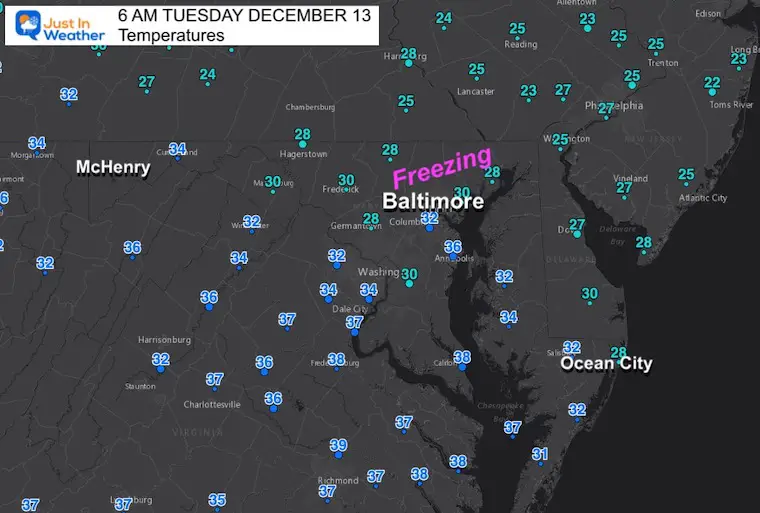
Morning Temperatures
Just a suggestion: The areas below freezing this morning are the places to be concerned for icy impact on Thursday morning.
Headlines
Today: Sunny and Cold
Storm Thursday: Icy Mix should begin before sunrise
Christmas Week: Arctic Air Will Make A Move
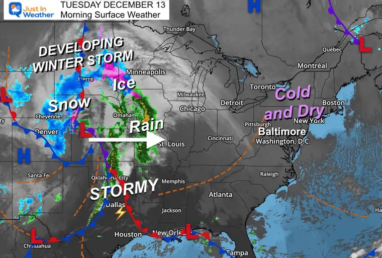
Morning Surface Weather
Winter Storm DEVELOPING across the central US. That is what will reach us by Thursday…. Until then: Simply cold and dry with sun and high clouds.
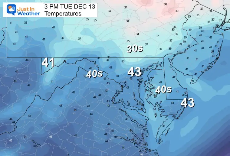
Afternoon Temperatures
These are below average and will feel colder with increasing clouds.
CLIMATE DATA
TODAY December 13
Normal Low in Baltimore: 30ºF
Record 8ºF in 1960
SNOW: 7.6 inches in 1966
Normal High in Baltimore: 48ºF
Record 72ºF 2015
Subscribe for eMail Alerts
NEW REPORT
Winter Perspective: Arctic Air Christmas Week
October 27 Nor’easter Recap Still Breezy Then Next Storm Friday
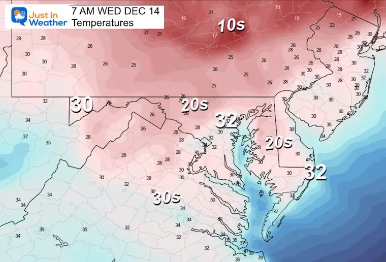
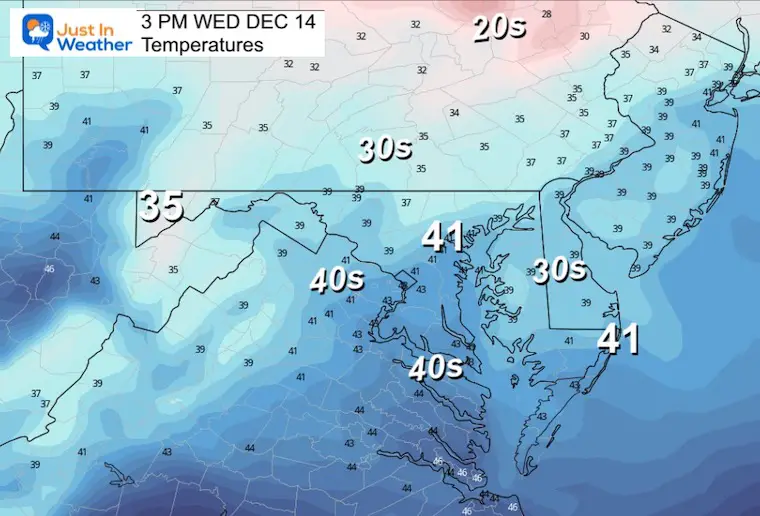
Wednesday Temperatures
Morning
Cold start under a clear sky, there may be some local spots much colder than shown here.
Afternoon
Increasing high clouds will dim the sun ahead of the storm.
Winter Event Starting Thursday December 15
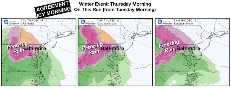
Model Comparison
The trend I have seen since yesterday has been more in agreement with both the start time and precipitation type. At this point it looks like this:
Thursday Morning
The good news in the agreement is that we will get a wintry mix, AND it will arrive before sunrise. This may help you plan ahead for school openings and travel.
- Pink: Freezing Rain
- Orange: Slushy Mix
- Blue: Snow
- Green: Rain
Thursday Morning Temperatures
While sleet and freezing rain may be falling, the ground temperatures will determine if the surface will turn wet or icy…
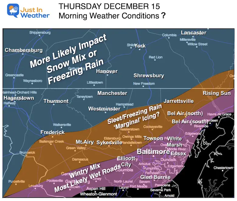
First ‘Guess’ Of Road Impact
This is the map I proposed yesterday. I will adjust this today as I think there may be more of Harford and Cecil County affected. Please check back later this morning.
Thursday Afternoon
This is the tricky part because the models handle the cold air and storm track differently. The GFS is still trying to turn to snow and hold that in the northern zones, while the Canadian Model holds the ice/freezing rain in our colder zones, and the European Model pushes the warmer air to the Pennsylvania line.

Storm Animations
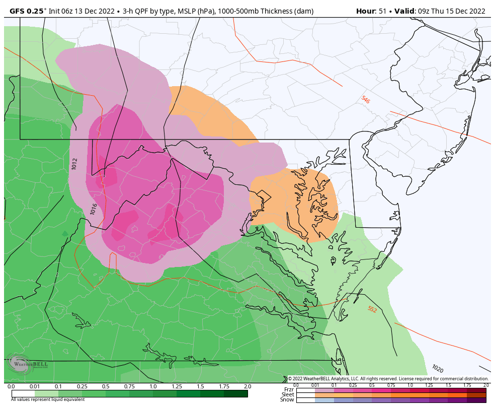
GFS Model:
This is the colder solution and I am not sold on the snow part yet. At least with the suggestion NWS has for some accumulation.
Canadian Model:
I am still partial to this solution with more impact from freezing rain to last into early afternoon for the colder inland zones.

After This…
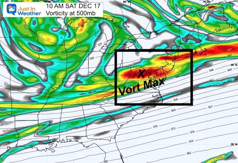
Weekend Jet Stream: Vorticity
This is the spin aloft that can support additional showers.
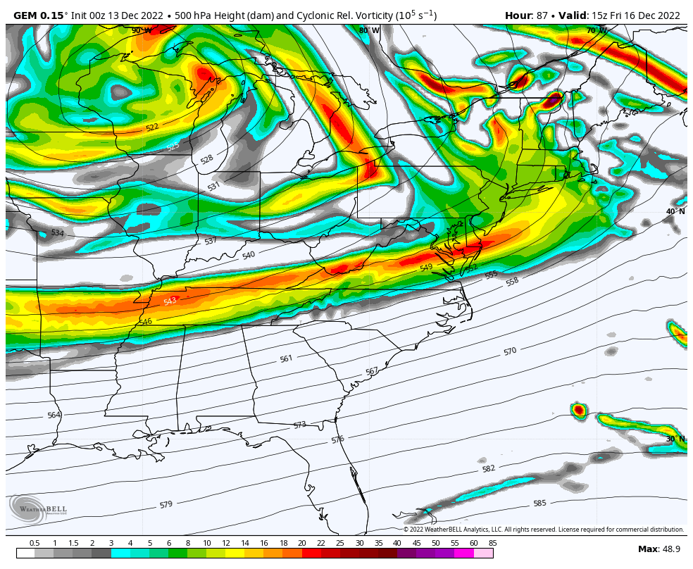
Saturday Afternoon:
I see a jet streak and Vort Max swinging through that may support a band of snow showers or flurries. This may repeat on Sunday as well.
Faith in the Flakes.
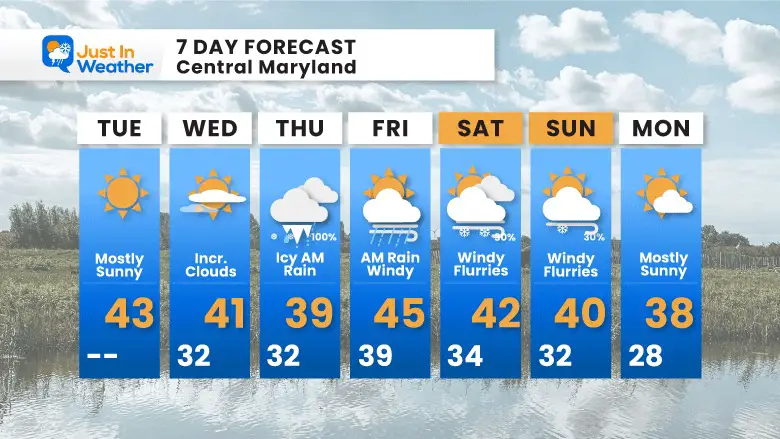
7 Day Forecast
Temps remain below average and the mother load of cold air may make a move just after this period and ahead of Christmas. With that I see two more attempts for snow or mix before Christmas, so it will remain active.
Faith in the Flakes Gear

SNOWSTIX – Available Now

STEM Assemblies/In School Fields Trips Are Back
Click to see more and ‘Book’ a visit to your school

My Winter Outlook: Not A Typical La Niña!
I see many factors to support colder influence with multiple systems. Early and later in winter. Check it out.
October 27 Nor’easter Recap Still Breezy Then Next Storm Friday
Also See The Winter Outlook Series:
October 27 Nor’easter Recap Still Breezy Then Next Storm Friday
Winter Outlook 2023 La Niña Triple Dip Expectations
Farmer’s Almanac Comparison
September Starts Meteorological Autumn: Weather Climate Stats For Maryland at Baltimore
Triple Dip La Niña Winter
Winter Outlook 2023 La Niña Triple Dip Expectations
CONNECTION TO WINTER?
If you want a snowy winter, this is what you might want to look for in the rest of the tropical season. (You might be seeing a lot of commercial snow removal people out this Winter).
Rainbow Ice Cave In Mt. Rainier A Very Rare Find: Photos And Video
Wooly Bear Caterpillars
https://justinweather.com/2022/10/25/winter-weather-outlook-from-the-wooly-bear-caterpillar/
Persimmon Seeds
Winter Weather Outlook: Persimmon Seeds And Snow Folklore
Click to see Top 20 and MORE
Winter Weather Folklore Top 20 And More Outlook Signals From Nature For Cold And Snow
Normals And Records: Maryland and Baltimore Climate History

Please share your thoughts, best weather pics/videos, or just keep in touch via social media


