Ice And Rain Event Then Arctic Air Makes A Move Before Christmas
Sunday Afternoon Update December 11 2022
Getting a weather pattern to change can sometimes be like moving the Titanic, but it is going to trend colder. The transition is already upon us with temperatures just below average. For snow lovers, this may not be cold enough. I have also heard the frustration about the upcoming winter event seeming to trend a little warmer. This is part of the process, and quite valuable while still in La Niña and getting other forces to maneuver for position.
Perspectives
There are three main ways I approach winter weather:
- Global Patters: This is long term trends with features like the Jet Stream, North Atlantic Oscillation, and Polar Vortex in play. That sets up a broad trend for warmer or colder and stormy weather that can last for days or weeks.
- Synoptic Weather: This relates to the actual storms. The Low Pressure (L and fronts on a weather map). I tend to call these ‘Events’ to limit the stigma of a ‘storm’ that can get blown out of proportion. I reserve the word storm for when I believe there will be impact and perhaps alerts issued.
- Local Daily Weather: This is the day to day expectation. While a Synoptic ‘Storm’ can produce snow and ice, this local weather approach is when we are within 48 to 72 hours and can refine the snow-ice-rain lines and even how much may pile up. This is more detailed per town or county, but can’t be done farther ahead in time.
Winter Event This Week
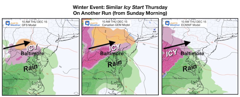
Now the I hope this makes a little more sense. Yes, it has looked like a winter event will affect us on Thursday in the week ahead. But now the synoptic features are trending to start with ice inland (rain south), and then the Low may track farther north and turn all of our region to rain. There may still be some wiggle room, but this is just the lead of the CHANGE on the way!
Thursday Morning Model Comparison
It is likely we have some freezing rain or mix to start, and typical colder areas west of I-95 are first in line to get this. This is worth tracking for the potential to impact morning travel. Warmer temps by the Bay and south may still bring just a chilly rain.
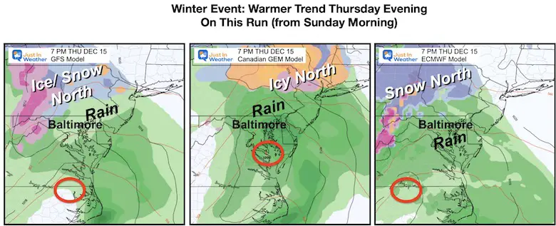
Thursday Evening Model Comparison
As the elements come together, the timing and location is forming and tracking the Low farther north. The result for a few model runs has brought rain through the region by evening.
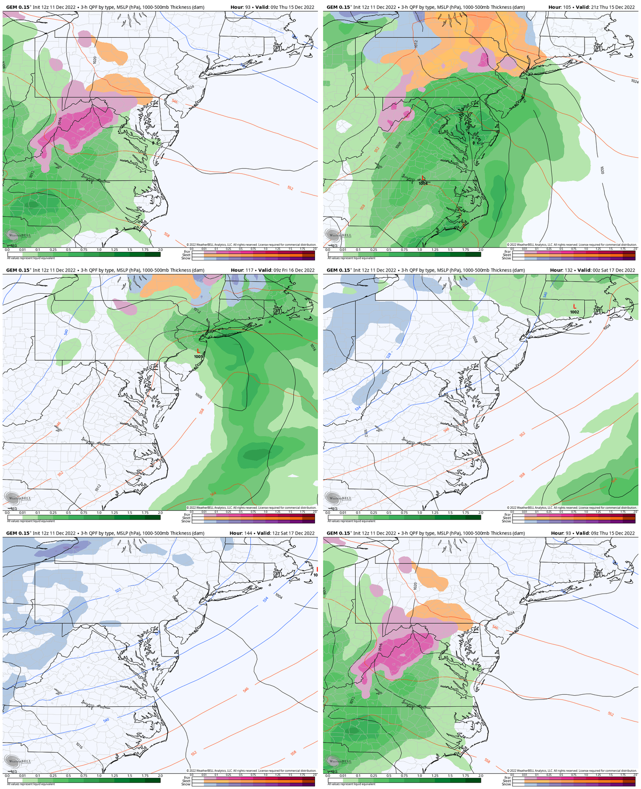
Storm Animation: Storm Animation
4 AM Thu to 7 AM Sat
This is the more dramatic solution, or worst case scenario. Inland ice, then all rain by evening. Then colder air arrives Friday night into Saturday. This could produce a few snow showers that the model can’t pick up on yet. There will be a lot of unstable air blowing over the Great Lakes as this arrives.
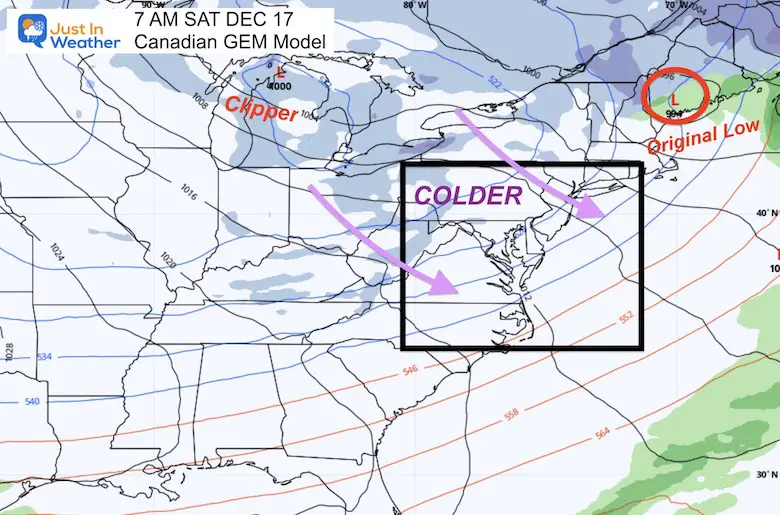
Wider View Helps Perspective
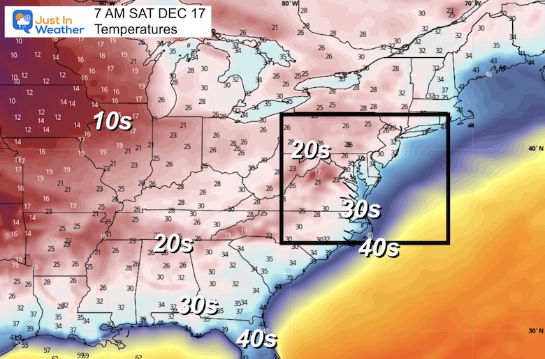
Saturday Morning
As the Low Pressure passes through New England, the cold air will easily flow in behind it. This cold air will reach the Atlantic and Gulf coasts.
There will be energy in the jet stream that may show as clippers and bring in some passing snow showers or light events the model does not show well yet.
Temperatures
The cold air mass will be deep and move all the way to the Gulf Coast. Check out the core in the 10s but the 30s reach into Northern Florida.
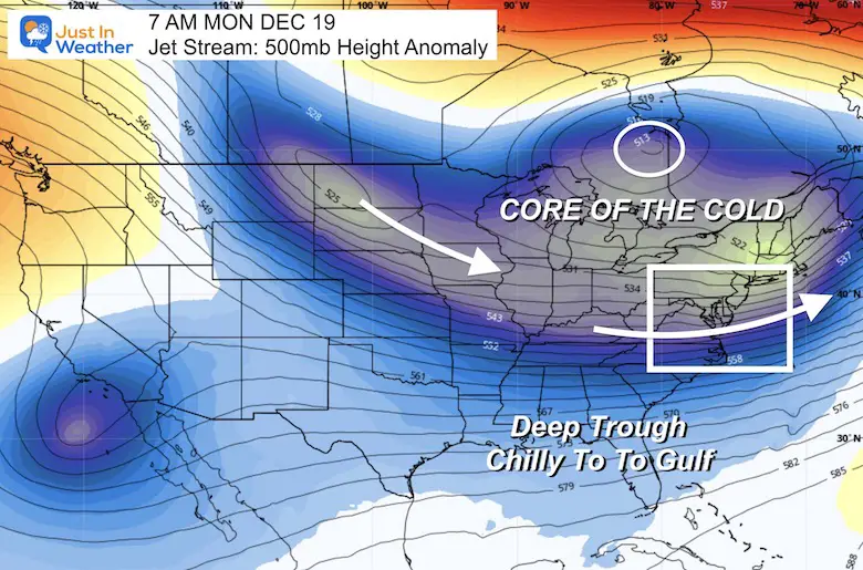
Jet Stream: Let The Arctic Air In
Snapshot Monday December 19
Here we see the deep trough establishing the next wave of cold air through the Mid Atlantic and Northeastern US.
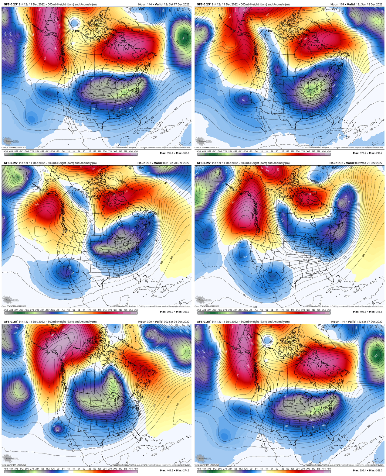
Animation: Jet Stream Through Christmas Day
Watch the evolution as the trough digs deeper and pushes the colder air into the Eastern US.
Subscribe for eMail Alerts
Weather posts straight to your inbox
Sign up and be the first to know!
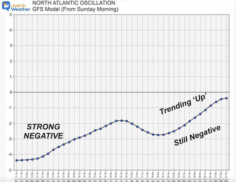
Global Pattern: North Atlantic Oscillation
You may have heard from me and other sources about this Index affecting winter temperatures. This measures the Greenland Block and air pressure in the North Atlantic that can direct cold air to the Eastern US when ‘Negative’.
We already have that, but watch it trend towards, but not quite at neutral over the next week. That is not a direct indication of warming. In fact, the temperature plot below from the GFS Model suggests otherwise.
Temperature Outlook (for Baltimore’s BWI) Through Christmas
What we see here is the first push of cold air following the ‘event’ this week. Then another push by Christmas brings in arctic air.
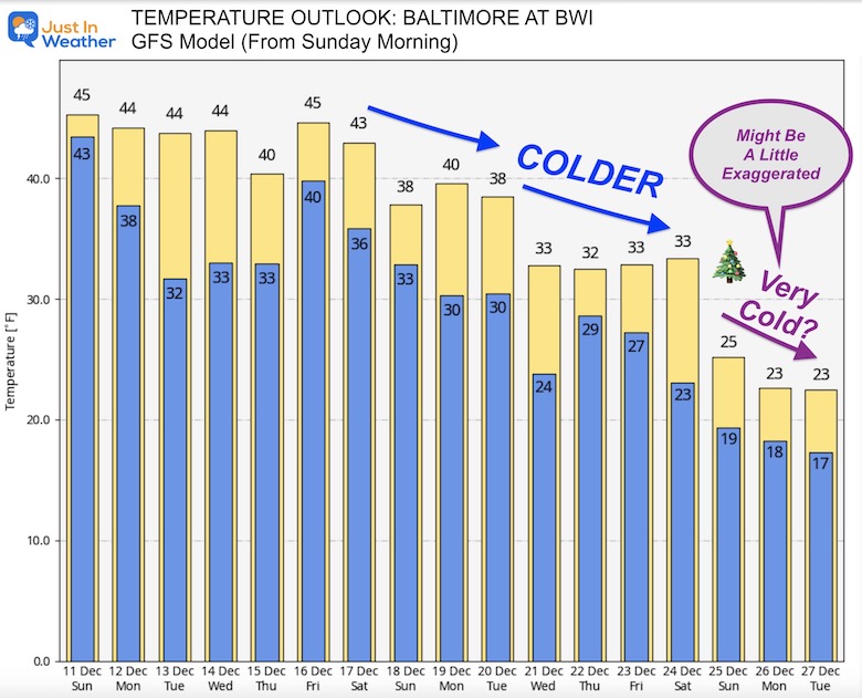
I must confess that this long range may be exaggerated a bit, which can happen with a major pattern change. But the signal is there to bring in legitimate winter air for Christmas Week. No promises for snow, but the chance will definitely increase with colder air in place over this long period of time.
Faith in the Flakes. We have a whole winter ahead of us and it is just getting started.
Faith in the Flakes Gear
SNOWSTIX – Available Now
STEM Assemblies/In School Fields Trips Are Back
Click to see more and ‘Book’ a visit to your school
My Winter Outlook: Not A Typical La Niña!
I see many factors to support colder influence with multiple systems. Early and later in winter. Check it out.
October 27 Nor’easter Recap Still Breezy Then Next Storm Friday
Also See The Winter Outlook Series:
October 27 Nor’easter Recap Still Breezy Then Next Storm Friday
Farmer’s Almanac Comparison
September Starts Meteorological Autumn: Weather Climate Stats For Maryland at Baltimore
Triple Dip La Niña Winter
CONNECTION TO WINTER?
If you want a snowy winter, this is what you might want to look for in the rest of the tropical season. (You might be seeing a lot of commercial snow removal people out this Winter).
Rainbow Ice Cave In Mt. Rainier A Very Rare Find: Photos And Video
Wooly Bear Caterpillars
https://justinweather.com/2022/10/25/winter-weather-outlook-from-the-wooly-bear-caterpillar/
Persimmon Seeds
Click to see Top 20 and MORE
Winter Weather Folklore Top 20 And More Outlook Signals From Nature For Cold And Snow
Normals And Records: Maryland and Baltimore Climate History
Please share your thoughts, best weather pics/videos, or just keep in touch via social media
-
Facebook: Justin Berk, Meteorologist
-
Twitter: @JustinWeather
-
Instagram: justinweather


