November 28 Windy Then Colder And Repeating Weather Recycled
Monday Morning Update
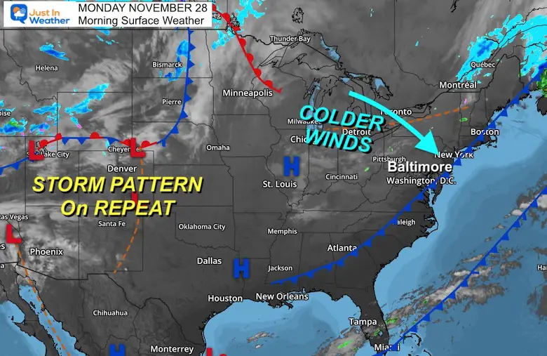
We are in a pattern of weather on repeat every 3 days. There is some fog leftover around Delmarva this morning, and a couple of light early showers. The wind will be the story today, which will try to clear out areas east of the mountains.
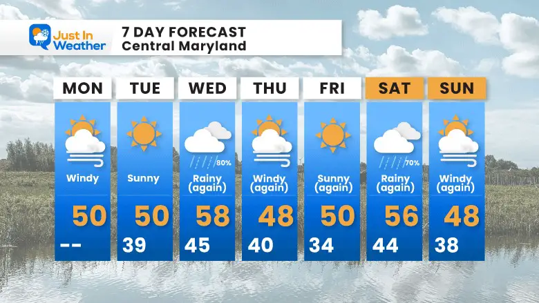
The pattern we have is a colder day with sun, followed by yet another storm with rain, followed by colder wind. This is our theme into the weekend. As we begin December, the global signals support the break to a new pattern over the next 7 to 10 days.
Morning Surface Weather
High is Dry! That big blue H is High Pressure and in control of the Eastern US. Our next storm is in East Texas and will reach us close to sunrise on Wednesday. There is enough energy with that southern system that could bring in a few heavy downpours and even a rumble of thunder.
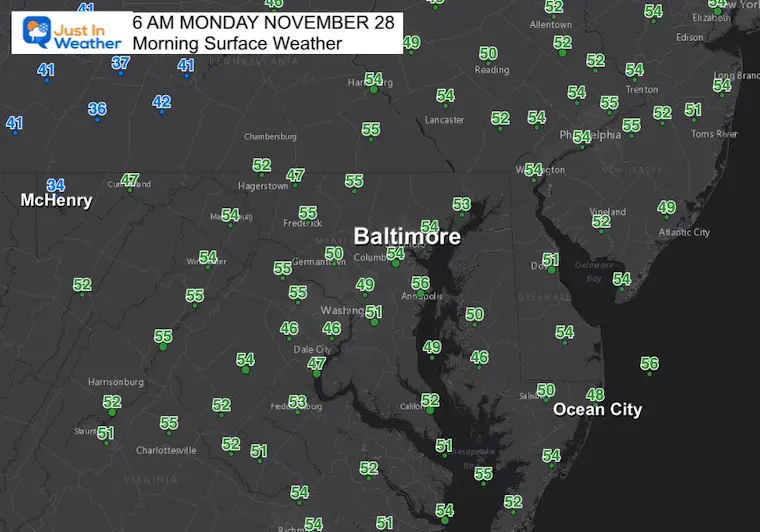
Morning Temperatures
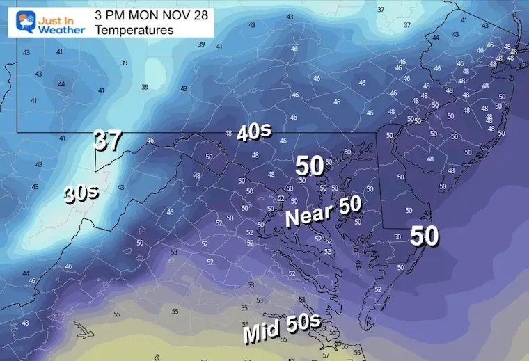
A mild start in the 50s, but temps will remain steady most of the day or will even drop during the afternoon with strong winds.
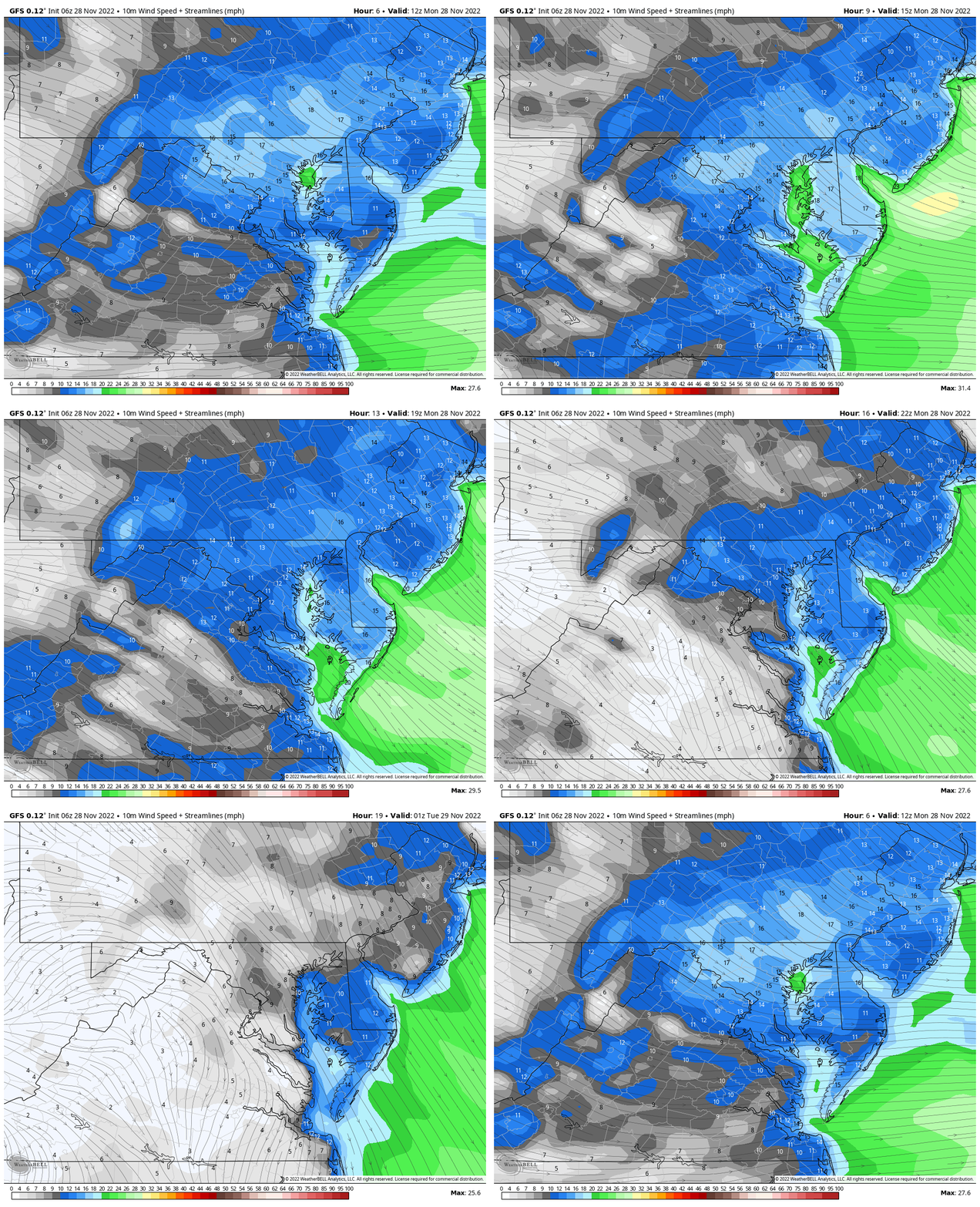
Wind Forecast
Monday 7 AM to 8 PM
Strong winds from the Northwest will battle the temps and hold us steady or bring on cooling this afternoon.
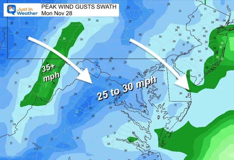
Wind Gusts
Top gusts will peak between 25 to 30 mph for most and some restrictions are possible on the bridges.
Temperatures Afternoon
NEW Faith In The Flakes Gear
CYBER MONDAY
20% Off All Items Through Today
CLIMATE DATA
TODAY November 28
Normal Low in Baltimore: 33ºF
Record 15ºF in 1951
SNOW: 1.7 inches in 1917
Normal High in Baltimore: 52ºF
Record 73ºF 1990
Subscribe to my Newsletter
Weather posts straight to your inbox
Sign up and be the first to know!
Tuesday
Winds will ease as High Pressure with cooler air settles in place.
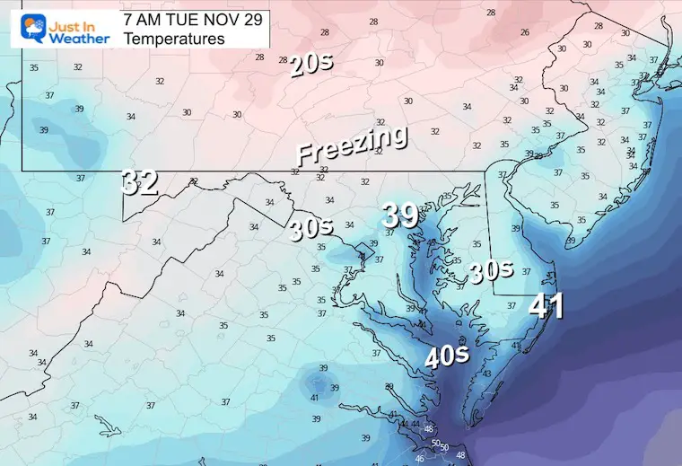
Morning Temperatures
The 30s are becoming more common.
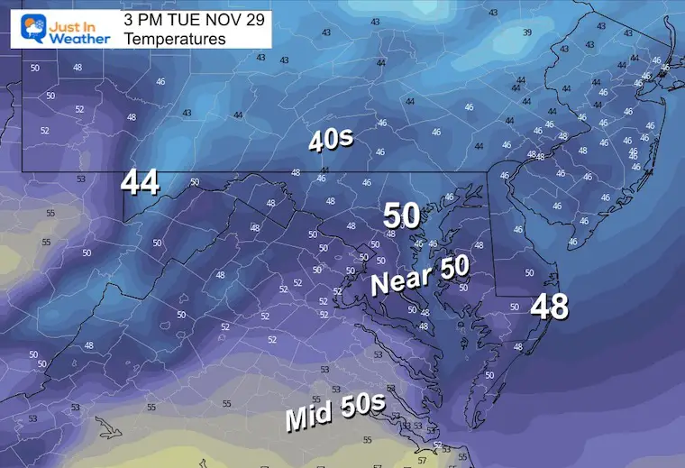
Afternoon Temperatures
Most of the region will remain in the mid 40s to near 50ºF.
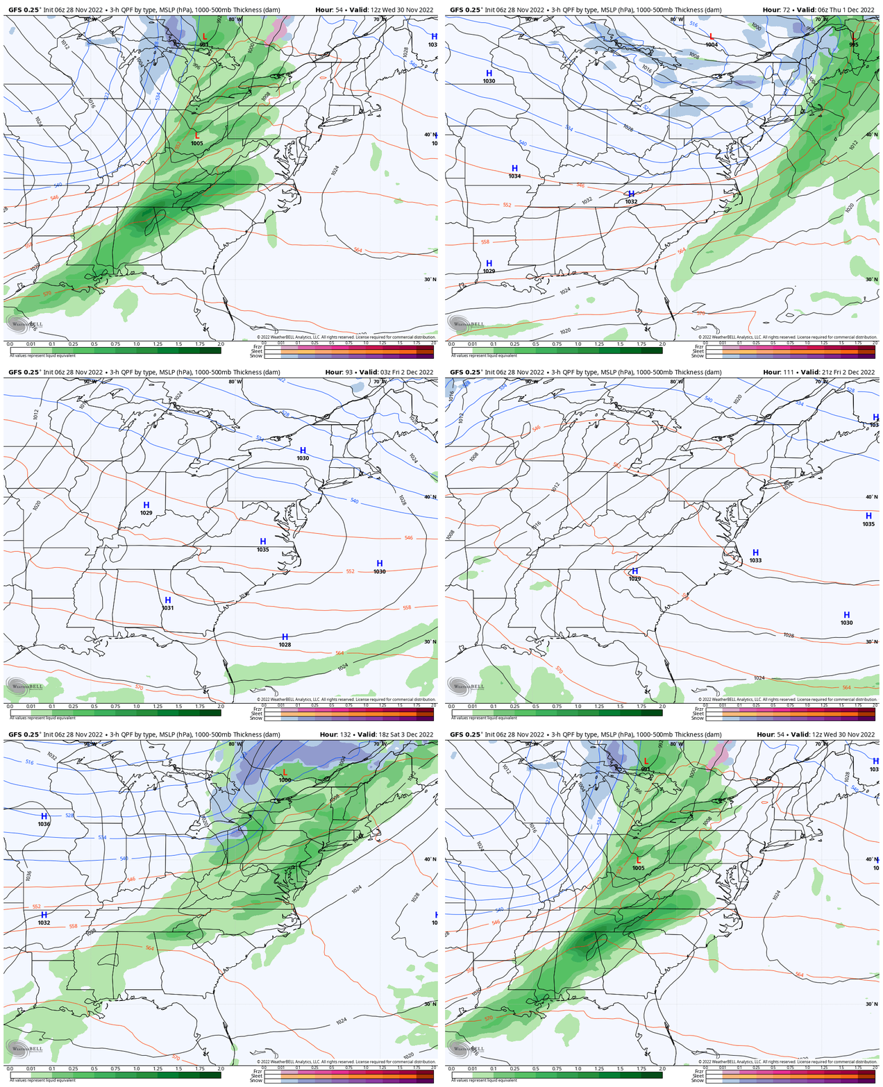
Next Two Events:
GFS Model Wednesday morning through Saturday evening
Repeating pattern every 3 days continues.
Rain Wednesday, windy Thursday, colder and dry Friday.
Then, Rain Saturday, windy Sunday, etc. We will see this reflected in the 7-Day Forecast…
NEW REPORTS:
December Pattern Change
How The Winter Weather Pattern May Develop In Early December
My Winter Outlook: Not A Typical La Niña!
I see many factors to support colder influence with multiple systems. Early and later in winter. Check it out.
October 27 Nor’easter Recap Still Breezy Then Next Storm Friday
7 Day Forecast
Also See The Winter Outlook Series:
October 27 Nor’easter Recap Still Breezy Then Next Storm Friday
Farmer’s Almanac Comparison
September Starts Meteorological Autumn: Weather Climate Stats For Maryland at Baltimore
Triple Dip La Niña Winter
CONNECTION TO WINTER?
If you want a snowy winter, this is what you might want to look for in the rest of the tropical season. (You might be seeing a lot of commercial snow removal people out this Winter).
Rainbow Ice Cave In Mt. Rainier A Very Rare Find: Photos And Video
Wooly Bear Caterpillars
https://justinweather.com/2022/10/25/winter-weather-outlook-from-the-wooly-bear-caterpillar/
Persimmon Seeds
Click to see Top 20 and MORE
Winter Weather Folklore Top 20 And More Outlook Signals From Nature For Cold And Snow
Faith in the Flakes Gear
SNOWSTIX – Available Now
Normals And Records: Maryland and Baltimore Climate History
STEM Assemblies/In School Fields Trips Are Back
Click to see more and ‘Book’ a visit to your school
Please share your thoughts, best weather pics/videos, or just keep in touch via social media
-
Facebook: Justin Berk, Meteorologist
-
Twitter: @JustinWeather
-
Instagram: justinweather


