Hurricane Nicole Upgraded To Cat 1 Ahead Of Florida Landfall Tonight
Wednesday, November 9
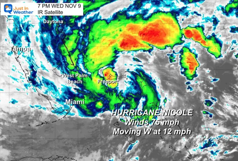
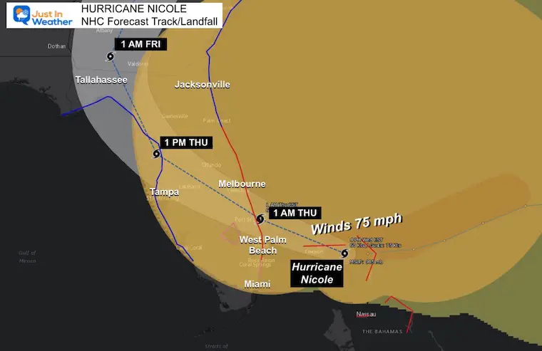
Nicole has become the 8th hurricane of the Atlantic season. It was named by The National Hurricane Center as it made landfall on Grand Bahama Island around 6 PM. The storm has 75 mph winds and continues on a path to the west toward Florida. Landfall is still on pace north of West Palm Beach after midnight.
The Live radar widget is below to track as it approaches Florida.
This storm center is not the main focus. There is a large area that will feel the impact of storm surge north of the center along the Atlantic coast of Florida, while heavy rain and isolated tornadoes will cross the mid portion of the state. The latest warnings and rain forecast through The Mid Atlantic are all listed below.
Satellite Snapshot
National Hurricane Center Report
7 PM EST Tuesday
LOCATION...26.6N 78.5W
ABOUT 20 MI…30 KM ENE OF FREEPORT GRAND BAHAMA ISLAND
ABOUT 100 MI…160 KM E OF WEST PALM BEACH FLORIDA
MAXIMUM SUSTAINED WINDS…75 MPH…120 KM/H
PRESENT MOVEMENT…W OR 280 DEGREES AT 13 MPH…20 KM/H
MINIMUM CENTRAL PRESSURE…980 MB…28.94 INCHES
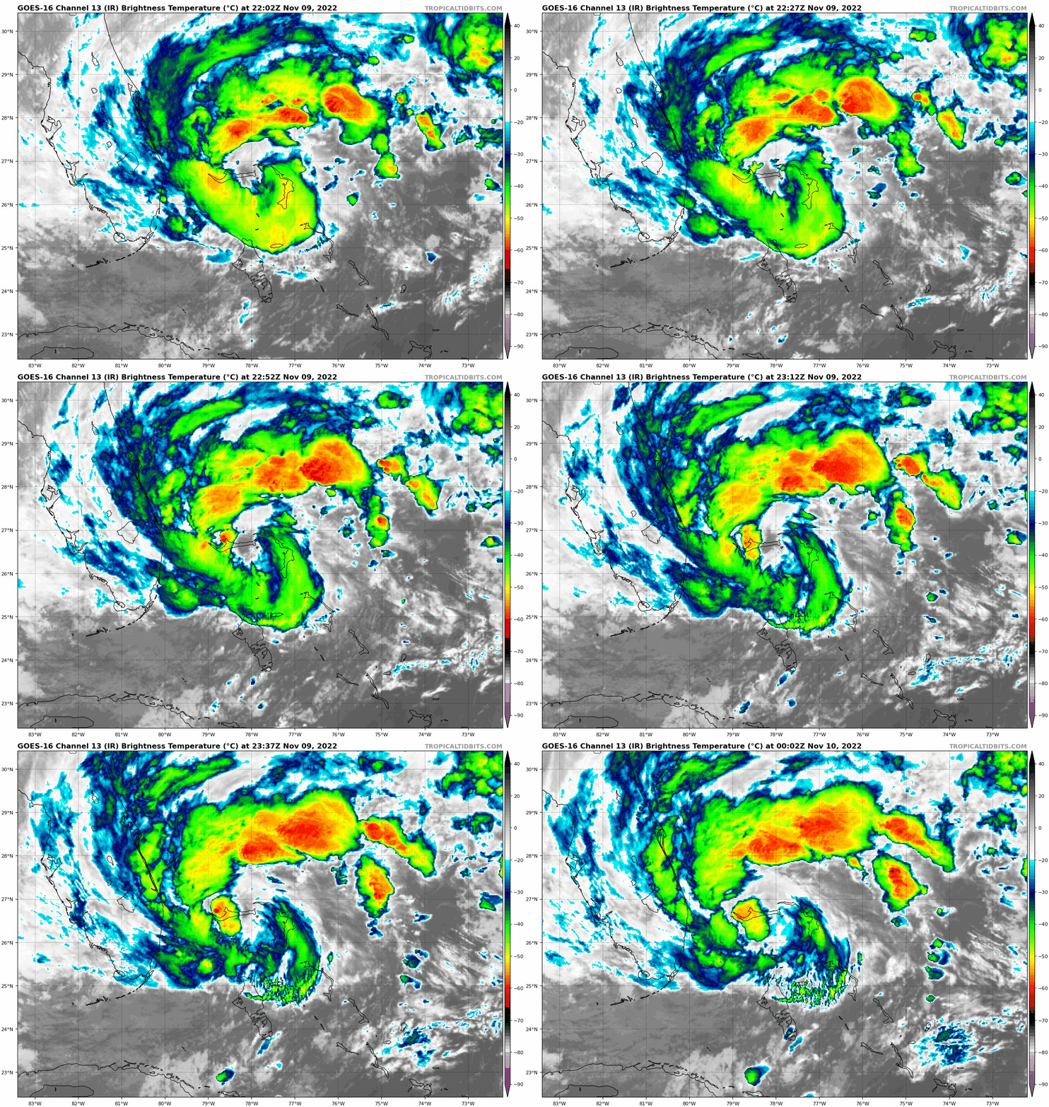
Evening IR Satellite Loop
Live Radar Widget
Pinch to zoom in or pan the view. Looping controls at the bottom.
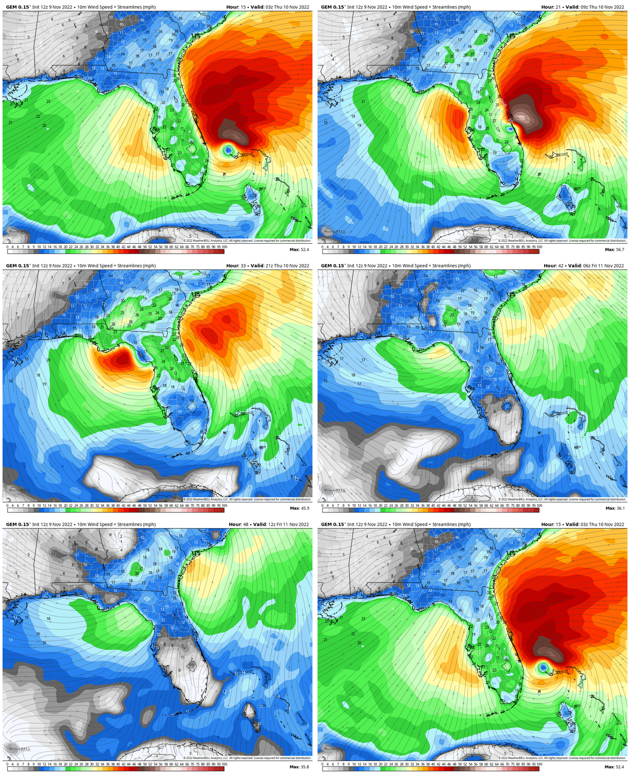
Wind Forecast Animation
10 PM WED to 7 AM FRI
A few notes:
Once inland, it will be downgraded back to a tropical storm and eventually a depression. That means the winds will weaken and the circulation will fall apart.
It will spread rain well ahead of the center, perhaps enough for flooding to be a concern.
Gusty winds and isolated tornadoes are possible.
The rain will be around for about 24 hours or less, so the weekend will NOT be a washout.
Landfall Track And Warnings
A Hurricane Warning is in effect for…
* The Abacos, Berry Islands, and Grand Bahama Island in the northwestern Bahamas
* Boca Raton to Flagler/Volusia County Line Florida
A Tropical Storm Warning is in effect for…
* Bimini in the northwestern Bahamas
* Hallandale Beach Florida to Boca Raton Florida
* Flagler/Volusia County Line Florida to South Santee River South Carolina
* North of Bonita Beach to Indian Pass Florida
* Lake Okeechobee
A Hurricane Watch is in effect for…
* Hallandale Beach to Boca Raton Florida
* Lake Okeechobee
Storm Surge Forecast
A Storm Surge Warning is in effect for…
* North Palm Beach Florida to Altamaha Sound Georgia
* Mouth of the St. Johns River to Georgetown Florida
* Anclote River Florida to Ochlockonee River Florida
A Storm Surge Watch is in effect for…
* Ochlockonee River to Indian Pass Florida
* South of North Palm Beach to Hallandale Beach Florida
* Altamaha Sound Georgia to South Santee River South Carolina

Tracking In The Mid Atlantic
7 AM FRI to 1 PM SAT
The track up the mountains will be well west of the cities. The heaviest rain will be inland. While there may be a break or lull in the evening, a second push of heavy rain will fall overnight.
This should end quickly Saturday morning.
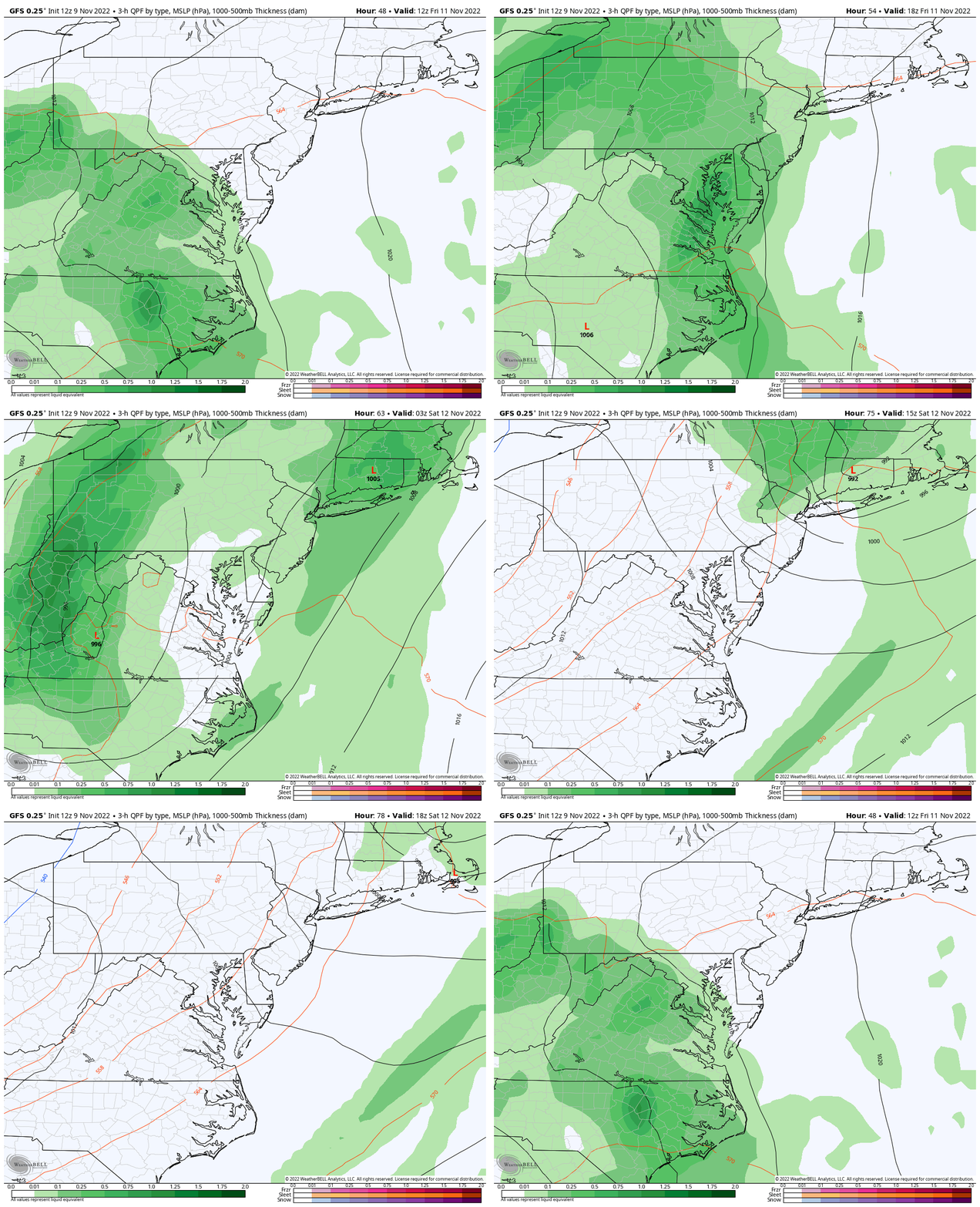
Rain Timeline —> slider
The rain will arrive during Friday morning and may be heavy at times, then a lull for the cities and around the Bay. The second round of heavy rain and possible severe storms may coincide with the core Low passing by overnight.
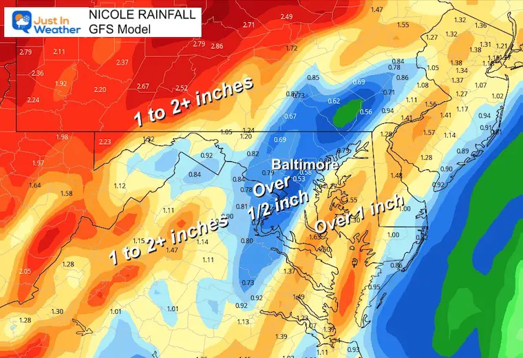
Rainfall Forecasts
GFS Model – this has lowered the metro rain totals, but still has a large region in the 1 to over 2-inch range.
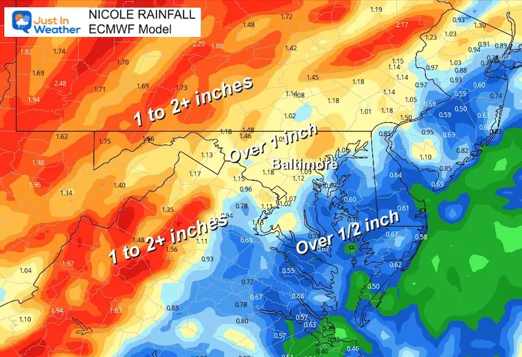
European ECMWF Model
This has been consistent with the coverage of the 1 to 2+ inch region.
Weather posts straight to your inbox
Sign up and be the first to know!
NEW: November Outlook Map From NOAA Showed This For The First Time
Winter Weather Folklore Top 20 And More Outlook Signals From Nature For Cold And Snow
Also See: Winter Outlook Series:
ALSO, SEE THESE OTHER WINTER OUTLOOK REPORTS
Farmer’s Almanac Comparison
September Starts Meteorological Autumn: Weather Climate Stats For Maryland at Baltimore
Triple Dip La Niña Winter
CONNECTION TO WINTER?
If you want a snowy winter, this is what you might want to look for in the rest of the tropical season. (You might be seeing a lot of commercial snow removal people out this Winter).
Rainbow Ice Cave In Mt. Rainier A Very Rare Find: Photos And Video
Wooly Bear Caterpillars
https://justinweather.com/2022/10/25/winter-weather-outlook-from-the-wooly-bear-caterpillar/
Persimmon Seeds
Click to see Top 20 and MORE
Winter Weather Folklore Top 20 And More Outlook Signals From Nature For Cold And Snow
Normals And Records: Maryland and Baltimore Climate History
Faith in the Flakes Gear
SNOWSTIX – Available Now
Please share your thoughts, best weather pics/videos, or just keep in touch via social media
-
Facebook: Justin Berk, Meteorologist
-
Twitter: @JustinWeather
-
Instagram: justinweather


