


July 5 Heating Up And Tropical Storm Chantal Expected To Get Named Today
Saturday, July 5 2025 Morning Report After the beautiful Independence Day we just had, we will see a little increase in heat and humidity today and tomorrow. There is a…
Monday, September 26, 2022
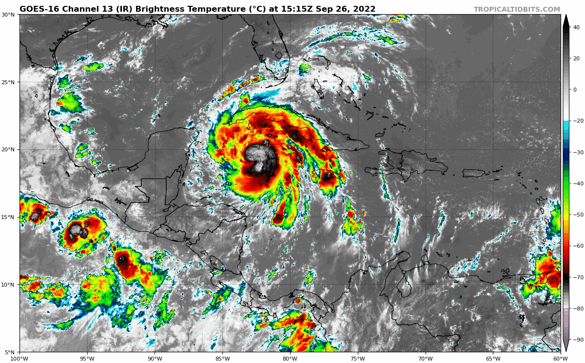
Hurricane Ian continues to intensity but as of Monday afternoon remained a Category 1. Top winds were sustained at 85 mph. Winds are expected to increase to over 130 mph in the next two days as it crosses western Cuba and enters very warm water. That is why mandatory evacuation orders were put in place for areas around Tampa. Governor DeSantis and FEMA encouraged people to move 20 miles inland due to flooding.
The focus of this report is the Florida flooding from two sources: Rainfall and storm surge. The places that get the combination of both will be most dire. However, the impact of the storm will be far-reaching. I will follow up with the rain impact and potential flooding up the East Coast to the Mid-Atlantic US.
It should be noted that in addition to the flooding impact, there will be damage from the wind itself and isolated tornadoes which come with landfalling tropical systems.
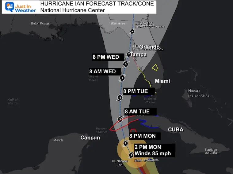
Please note that this (and other storms) have verified West or LEFT side of the cone, this has come back a little East. There is still some wiggle room and uncertainty with landfall.
The National Hurricane Center has this west of Tampa, but the strongest winds and water surge will be on the right side up along the Florida coast.
A Storm Surge Watch is in effect for…
* Florida Keys from the Card Sound Bridge westward to Key West
* Dry Tortugas
* Florida Bay
* Anclote River southward to the Card Sound Bridge
* Tampa Bay
A Hurricane Watch is in effect for…
* Englewood to the Anclote River, including Tampa Bay
A Tropical Storm Watch is in effect for…
* Little Cayman and Cayman Brac
* Englewood southward to Flamingo
* Florida Keys from Seven Mile Bridge to the Channel 5 Bridge
* Lake Okeechobee
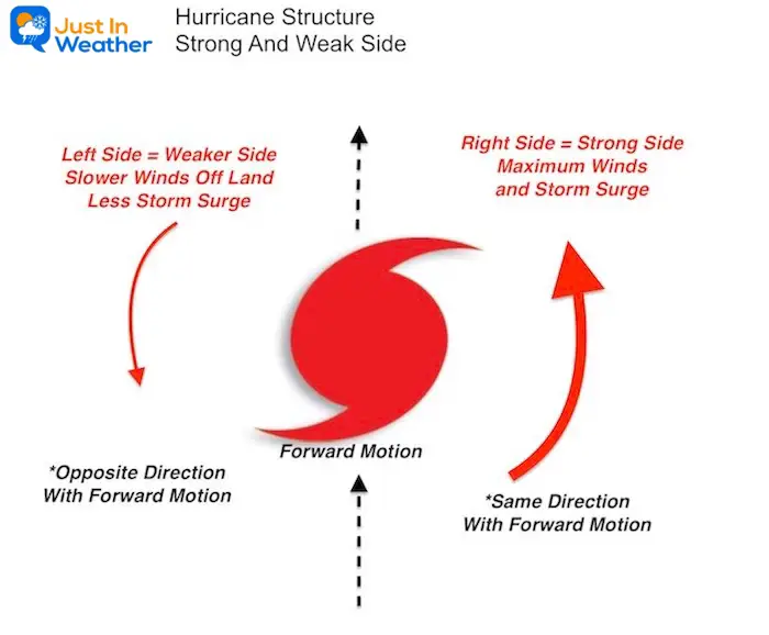
With respect to forward motions, the RIGHT (East in this case) has the winds and water moving with the forward direction. This will bring the maximum impact to Florida. The LEFT (West in this case) side has the wind and water flow opposing the forward motion, thus contradicting itself and resulting in weaker impact. This will be over the open Gulf.
The trouble seen here with this forecast solution is the slow down of the storm right along the coast near Tampa.
It may barely move or stall Wednesday into Thursday, before getting a push back to the north again.
While it may not have a direct landfall, the stronger side will be pounding the coast for a long duration.
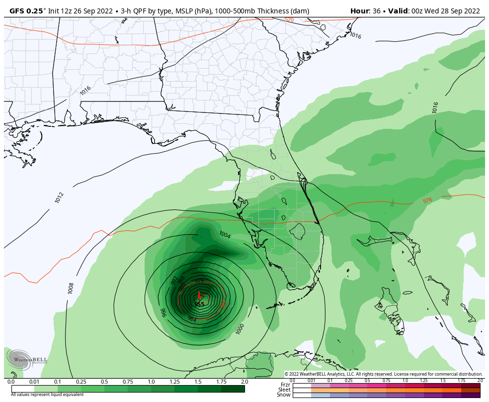
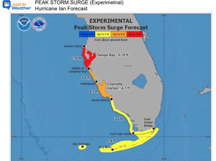
The National Hurricane Center predicts up to 10 foot storm surge into Tampa Bay!
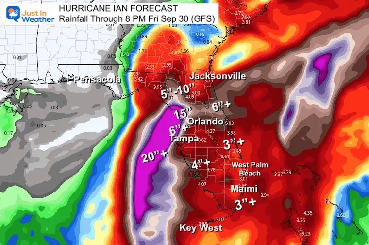
The GFS Model plot has a large area of over 4 inches of rain, but the immediate coastline near and north of Tampa are in the 5 to 15 inch rainfall potential. Again, this is water falling down from the sky. This will be in addition to the water pushed up from the storm surge.
STORM SURGE: The combination of storm surge and the tide will cause normally dry areas near the coast to be flooded by rising waters moving inland from the shoreline. The water could reach the following heights above ground somewhere in the indicated areas if the peak surge occurs at the time of high tide…
*Anclote River to Middle of Longboat Key, FL including Tampa Bay…5-10 ft
*Middle of Longboat Key, FL to Englewood, FL…5-8 ft
*Englewood, FL to Bonita Beach, FL including Charlotte Harbor…4-7 ft
*Bonita Beach, FL to East Cape Sable, FL…3-5 ft
*East Cape Sable, FL to Card Sound Bridge, FL including Florida Bay...2-4 ft
*Florida Keys including the Dry Tortugas…2-4 ft
The deepest water will occur along the immediate coast near and to the right of the center, where the surge will be accompanied by large waves. Surge-related flooding depends on the relative timing of the surge and the tidal cycle, and can vary greatly over short distances.
Storm surge could raise water levels by as much as 9 to 14 feet above normal tide levels along the coast of western Cuba in areas of onshore winds in the hurricane warning area tonight and early Tuesday.
Storm surge could raise water levels by as much as 2 to 4 feet above normal tide levels along the immediate coast in areas of onshore winds in the Cayman Islands today.
RAINFALL: Ian is expected to produce the following rainfall through Thursday:
Jamaica: An additional 1 to 3 inches, with local maximum of 5 inches, especially along the south coastal region.
Cayman Islands: 3 to 6 inches, with local maxima up to 8 inches.
Western Cuba: 6 to 10 inches, with local maxima up to 16 inches.
These rains may produce flash flooding and mudslides in areas of higher terrain over western Cuba.
Florida Keys: 4 to 6 inches.
Central West Florida: 8 to 10 inches, with local maxima up to 15 inches.
Remainder of the Florida Peninsula: 3 to 8 inches.
Heavy rainfall is expected to affect North Florida, eastern portions of the Florida Panhandle, and portions of the Southeastern U.S. Friday and Saturday.
Widespread considerable flash and urban flooding and prolonged significant river flooding impacts are likely mid-to-late week in central Florida given already saturated conditions. Flash and urban flooding impacts are also possible with rainfall across the Florida Keys and the Florida peninsula through mid-week. Limited flooding impacts and rises on area streams and rivers are also possible over northern Florida and portions of the Southeast mid-to-late week.
If you want a snowy winter, this is what you might want to look for in the rest of the tropical season.
Record August For No Named Tropical Storms: Closer Look At Snow Following
NOAA 2022 Hurricane Forecast- Above Normal Again

NOAA Study: Reducing Air Pollution INCREASED Tropical Storms

Atlantic Tropical History: Maps of Origin Regions Every 10 Days


Click to see more and ‘Book’ a visit to your school
