Saturday September 24, 2022
There has been a burst of activity in the Atlantic in the past week, and now there are four named storms on the map. It is the latest storm that is of most interest to us, because Ian is expected to track through the Caribbean and reach the US next week as a Category 3 hurricane. I have some reservations about the current track, which we will get into below.
A Tropical Storm Watch has been issued for Jamaica and a Hurricane Watch for the Cayman Islands. Maps below…
Active Atlantic Tropical Tracks
Here is a look at the historical paths and forecast tracks/cones of these active storms.
Notice the parallel of Fiona and Ian. Storms often turn north then northeast when they interact with mid latitude upper level winds.

Fiona – This is Post Tropical and still has 90 mph winds. This is one of the strongest remnant tropical storms to hit Nova Scotia. It is also a system that might play a role in shaping winter storm tracks. It is near the location of where semi-permanent Lows can sit and spin cold air for the eastern US at the 50 lat/50 long location.
Gaston – This has looped around the central Atlantic. It has winds of 50 mph and is no threat to land.
Hermine – Was just named Friday off the coast of Africa. It has 40 mph winds.
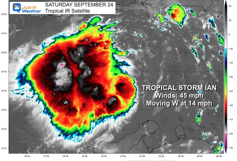
Ian – Also named late Friday and what we will be focusing on here. It currently has 45 mph winds.
Wide Atlantic Satellite Snapshot

Tropical Storm Ian Snapshot
This is expected to get organized in a hurry. There is already a lot of convection/thunderstorm activity. Rapid development and upgrade to a Category 1 hurricane with winds over 74 mph is expected by Sunday.
Quick Stats
- Winds are 45 mph
- Moving to the West at 45 mph
- Tropical Storm force winds extend 45 miles from the center
Satellite Loops
(I have to embed from my Twitter feed until I can fix the animations)
Close Up
Wide View
Forecast Computer Model Intensity:
There is a large cluster of models showing it pushing Category 3 – Major Hurricane Intensity – before reaching the US coast.

Forecast Track/Cone: National Hurricane Center
I need point out that the last couple of storms, including Fiona have trended to the LEFT side of the initial track. If we see that same bias with Ian, it could make a big difference in the potential intensity and where it ends up in the US.
It has already shifted farther West from the initial forecast, so this is not a lock for Tampa. I expect some adjustments…
As of this morning, the expectation is for a landfall on western Cuba early Tuesday, then western Florida on Wednesday morning.

WIND WIDGET FORECAST
National Hurricane Center Forecast Notes:
RAINFALL: Ian is expected to produce the following rainfall:
Southern Haiti and Southern Dominican Republic: 2 to 4 inches, with local maximum up to 6 inches
Jamaica and the Cayman Islands: 4 to 8 inches, with local maximum up to 12 inches
Western to central Cuba: 6 to 10 inches, with local maximum up to 14 inches
These rains may produce flash flooding and mudslides in areas of higher terrain, particularly over Jamaica and Cuba.
Florida Keys and South Florida: Heavy rains could begin as early as Monday. Limited flash and urban flooding is possible with this rainfall.
STORM SURGE: Storm surge could raise water levels by as much as 1 to 3 feet above normal tide levels along the immediate coast in areas of onshore winds in the Cayman Islands, Sunday night into Monday.
COMPARE TO THE PAST
If you want a snowy winter, this is what you might want to look for in the rest of the tropical season.
Record August For No Named Tropical Storms: Closer Look At Snow Following
Hurricane Season Forecast: June 1 Through November 30
NOAA 2022 Hurricane Forecast- Above Normal Again

Related Posts
NOAA Study: Reducing Air Pollution INCREASED Tropical Storms

Atlantic Tropical History: Maps of Origin Regions Every 10 Days


Please share your thoughts, best weather pics/videos, or just keep in touch via social media
STEM Assemblies/In School Fields Trips Are Back
Click to see more and ‘Book’ a visit to your school


