


Soggy Saturday Update: Rain Timeline Through Preakness In Baltimore
Friday, May 17, 2024 As we approach another weekend, we have yet another weather system bringing us rain. This will make 16 of 20 weekends this year with some wet…
Saturday September 17, 2022
Morning Update
Tropical Storm Fiona has been a challenge for the few days since its inception. First it outperformed models and developed rapidly. Then on Thursday we watched the circulation separate from the deep convection and the naked circulation was exposed. On Friday the storm shifted south of the forecast track, which allowed the upper level convection to catch up, wrap around, and reorganize.
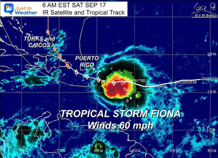
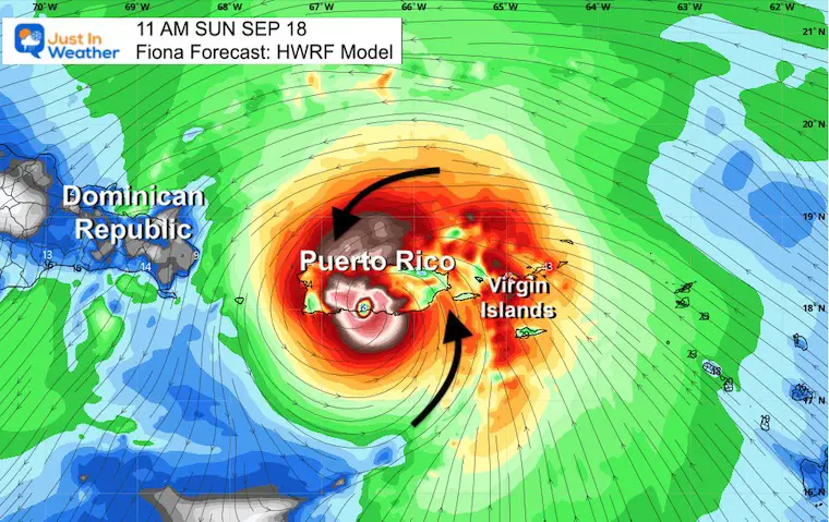
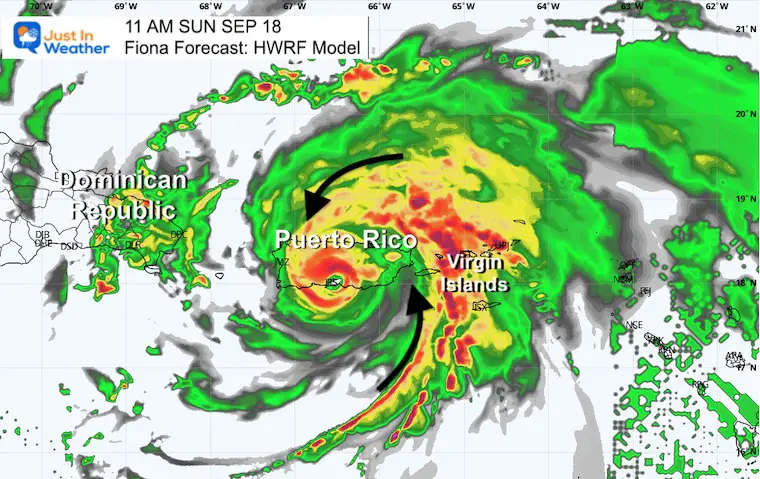
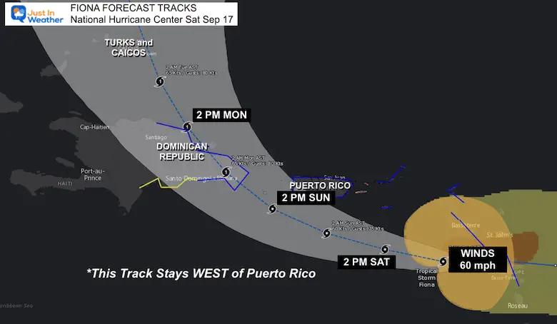
Today we have a new perspective: Tropical Storm Fiona is expected to become a hurricane and the path may cross over or just west of Puerto Rico. This would place the strongest winds and rain over Puerto Rico on Sunday. Over 10 inches of rain may fall there. See below.
(The web set has been having issues with some GIFs, so I have this loop embedded from Twitter first, then I attempted to place the loop below.)
See Live Radar below.
Loop:
If this does not animate, see my Tweet embedded below:
Another Look
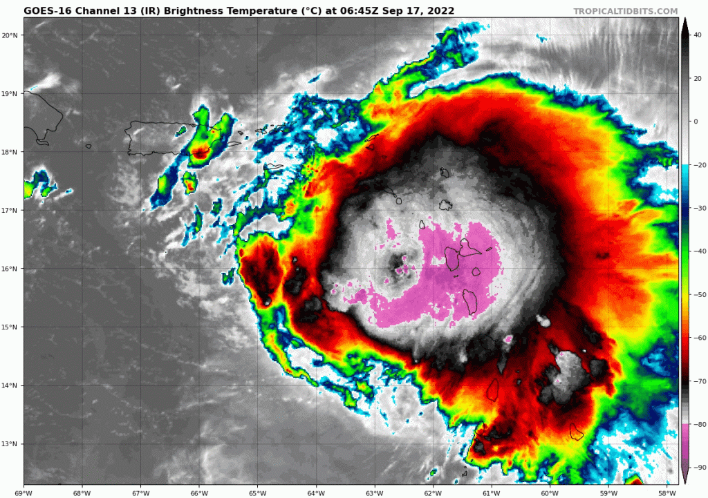
Tropical Storm Fiona Satellite Saturday Morning: This storm is reorganizing and now expected to become a Category 1 Hurricane. Forecast to hit or pass just west of Puerto Rico on Sunday pic.twitter.com/PsmOpIrta4
— Justin Berk (@JustinWeather) September 17, 2022
Snapshot
This demonstrates the problem the Atlantic has had generating storms all season. There is a lot of wind sheer. Stronger upper level winds are blowing from the west, cutting the top off of the storm, exposing the center, and limiting further intensification.
Tropical Storm Fiona
SUMMARY OF 500 AM AST…0900 UTC…INFORMATION
———————————————-
LOCATION…16.4N 63.3W
ABOUT 125 MI…205 KM W OF GUADELOUPE
ABOUT 135 MI…215 KM SE OF ST. CROIX
MAXIMUM SUSTAINED WINDS…60 MPH…95 KM/H
PRESENT MOVEMENT…W OR 275 DEGREES AT 13 MPH…20 KM/H
MINIMUM CENTRAL PRESSURE…1000 MB…29.53 INCHES
SUMMARY OF WATCHES AND WARNINGS IN EFFECT:
A Hurricane Watch is in effect for…
* Puerto Rico, including Vieques and Culebra
A Tropical Storm Warning is in effect for…
* St. Kitts, Nevis, Montserrat, and Anguilla
* Saba and St. Eustatius
* St. Maarten
* Guadeloupe, St. Barthelemy, and St. Martin
* Puerto Rico, including Vieques and Culebra
* U.S. Virgin Islands
* British Virgin Islands
* South coast of the Dominican Republic from Cabo Engano westward
to Cabo Caucedo
* North coast of the Dominican Republic from Cabo Engano westward to
Puerto Plata
A Tropical Storm Watch is in effect for…
* South coast of the Dominican Republic from Cabo Caucedo westward
to Barahona
The combination of storm surge and the tide will cause normally dry areas near the coast to be flooded by rising waters moving inland from the shoreline. The water could reach the following heights above ground somewhere in the indicated areas if onshore winds and the peak surge occur at the time of high tide…
Southern coast of Puerto Rico…1 to 3 ft
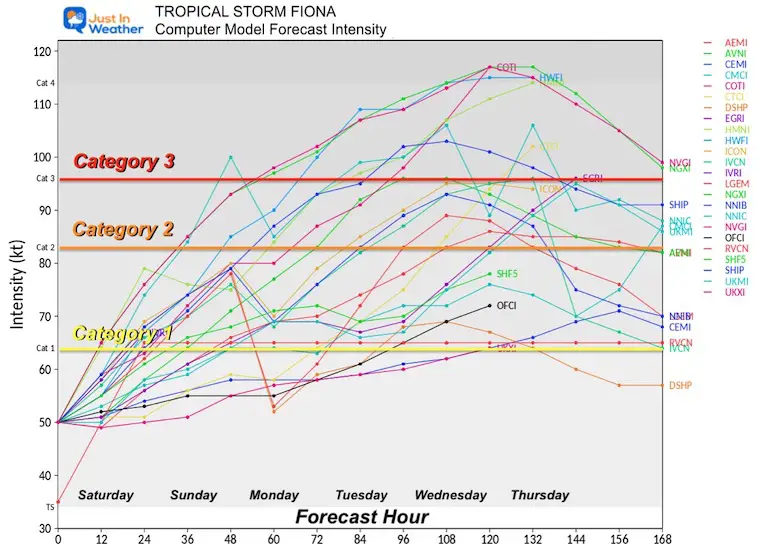
There is NOW a lot more support for this to reach at least a Category 1 Hurricane.
NOAA/National Hurricane Center
Puerto Rico should get the worst of this storm on Sunday.
WEATHER WIDGET LIVE RADAR
RAINFALL: Fiona is forecast to produce the following rainfall:
Leeward Islands and Northern Windward Islands: Additional 2 to 4 inches.
British and U.S. Virgin Islands: 4 to 6 inches with local 10 inches possible.
Puerto Rico: 5 to 10 inches with local 16 inches possible, particularly across eastern and southern Puerto Rico.
Dominican Republic: 4 to 8 inches with 12 inches possible, particularly on the far eastern coast.
Haiti: 1 to 3 inches with isolated maximum totals of 4 inches.
Turks and Caicos: 4 to 10 inches.
Most ensembles show this curving through the Bahamas then east of the US coast. I say most, because there are some outliers and we must consider that so far this has not been handled well with computer models… and verifying to the LEFT of the expectations.
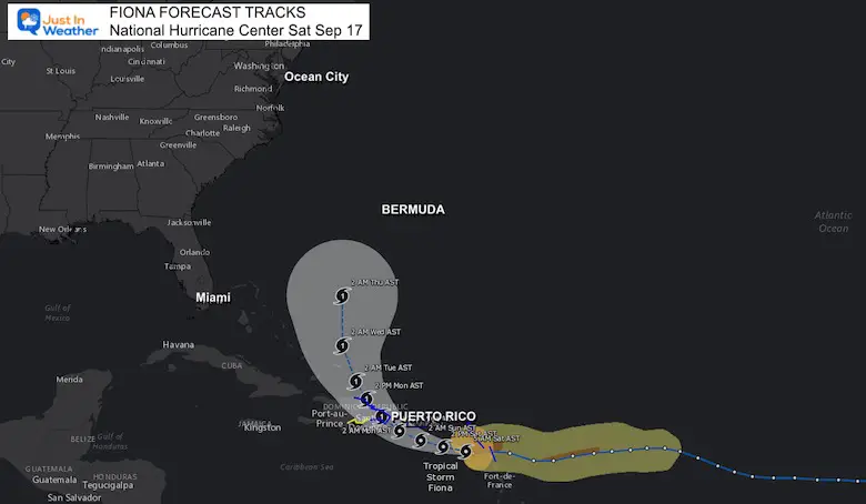
Euro ensembles show a few outliers threatening the U.S., but most do not. pic.twitter.com/uyYDoFp0lw
— Tom Tasselmyer (@ttasselWBAL) September 16, 2022
Atlantic Tropical History: Maps of Origin Regions Every 10 Days


NOAA Study: Reducing Air Pollution INCREASED Tropical Storms

If you want a snowy winter, this is what you might want to look for in the rest of the tropical season.
Record August For No Named Tropical Storms: Closer Look At Snow Following
NOAA 2022 Hurricane Forecast- Above Normal Again


Click to see more and ‘Book’ a visit to your school
