Tuesday November 8
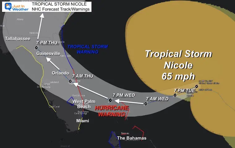
Tropical Storm Nicole is getting better organized and well on its way to becoming a hurricane on Wednesday. This evening the winds are 65 mph and is approaching the Northern Bahamas en route to landfall in Florida.
Hurricane Warnings as well as Storm Surge Warnings are in place for the mid portion of the East Coast of Florida. The landfall is expected on Thursday morning, then as it turns north it will speed up. Rain is expected to reach our region in the Mid Atlantic by Friday morning. This is the focus for this report, so perhaps you can plan ahead. A second event may follow on Sunday with colder air and snowflakes in the mountains.
A few notes:
Once inland, this will be downgraded back to a tropical storm and eventually a depression. That means the winds will weaken and the circulation will fall apart.
It will spread rain well ahead of the center, perhaps enough for flooding to be a concern.
Gusty winds and isolated tornadoes are possible.
The rain will be around for around 24 hours or less, so the weekend will NOT be a washout.
Let’s take a look:
Evening Satellite Loop
National Hurricane Center Report
7 PM EST Tuesday
- LOCATION…27.3N 74.3W
- ABOUT 250 MI NE OF THE NORTHWESTERN BAHAMAS
- ABOUT 360 MI E OF WEST PALM BEACH FLORIDA
- MAXIMUM SUSTAINED WINDS…65 MPH…100 KM/H
- PRESENT MOVEMENT…WSW OR 250 DEGREES AT 10 MPH…17 KM/H
- MINIMUM CENTRAL PRESSURE...984 MB…29.06 INCHES
Landfall Track And Warning
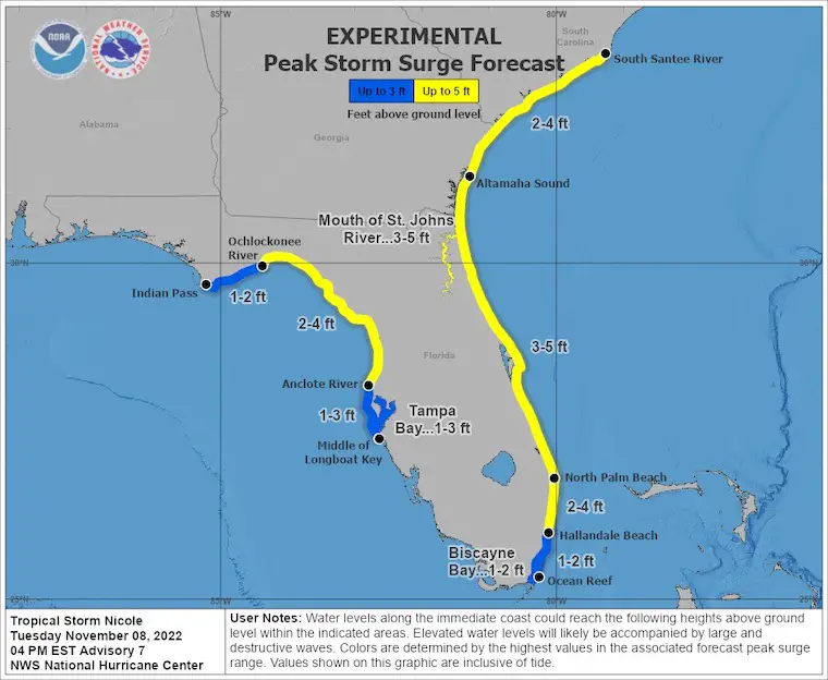
Storm Surge Forecast: Experimental
A large area of Florida may get up to 5 Ft. waters.
A Storm Surge Warning is in effect for...
- * North Palm Beach Florida to Altamaha Sound Georgia
- * Mouth of the St. Johns River to Georgetown Florida
A Storm Surge Watch is in effect for...
- * South of North Palm Beach to Hallandale Beach Florida
- * Altamaha Sound Georgia to South Santee River South Carolina
- * Anclote River Florida to Ochlockonee River Florida
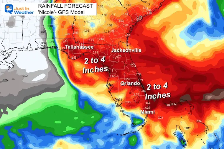
Florida Rainfall Forecast
Forecast Track North:
1 PM Wed to 1 PM Sat
This animation is the GFS Model. I will compare key timeframes with the European Model below.
This will be an inland track up the mountains. It is NOT a storm surge worry for the Mid Atlantic. It should be noted that this track has shifted well west of the expectation yesterday, and there may be some more adjustment. That is all based on the short term speed and landfall location, to follow how it will interact with the weather set up in the Mid Latitudes.
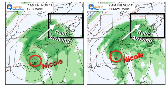
Model Comparison
The good news is that at this point, there is very little difference between the GFS and European models. That means they have a good handle on this event. There are some subtle differences, but overall this is the expectation:
Friday Morning at 7 AM
Rain will be moving in or already in place. This will set up a wet day!
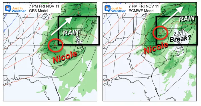
Friday Evening at 7 PM
After a rainy day, the heaviest rain should be inland across the mountains, and moving up north. The European Model shows more of a break or lull in the rain around metro Baltimore and Delmarva.
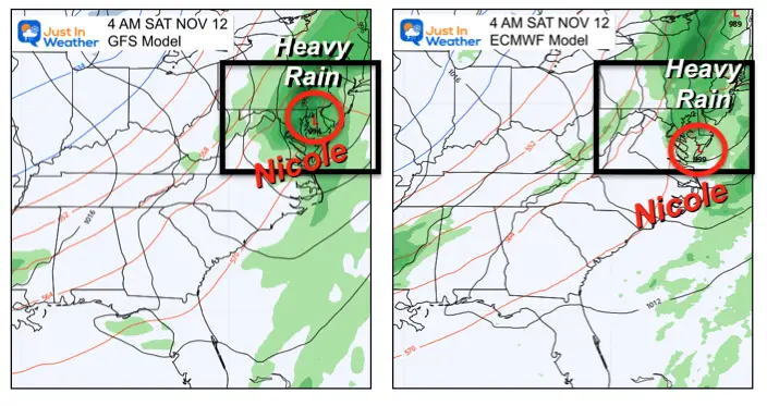
Early Saturday Morning at 4 AM
The storm is not done! The heaviest rain and strongest with the Core Low is expected to pass through between midnight and daybreak on Saturday.
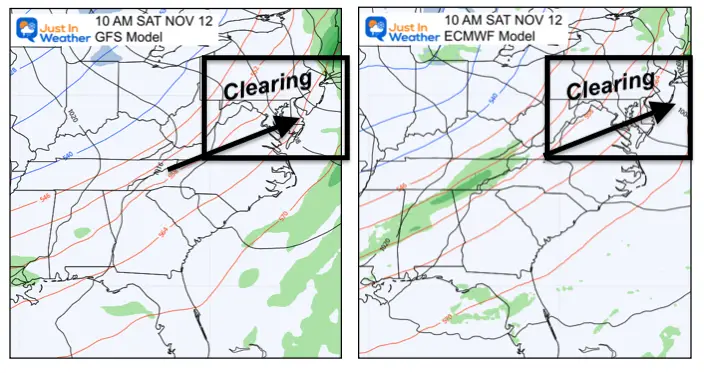
Mid Morning Saturday at 10 AM
By this time, the accelerating ‘Ghost’ of Nicole should be racing through New England.
Not only will the rain likely end before noon, but the sun may very well come out as well.
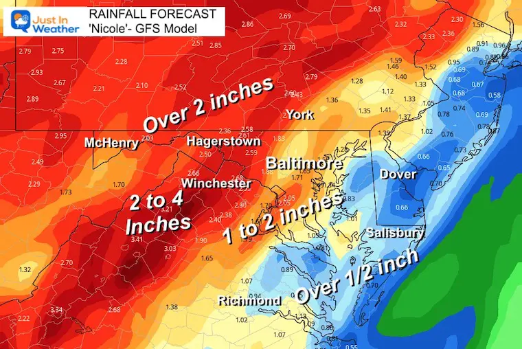
Rainfall Forecast Comparison
There are slight differences in the line up for the heaviest rain, but the heavy rain zone will be 2 inches or higher. That could spark some local flooding Friday night.
GFS Model
Rainfall will increase farther inland west and north of the Chesapeake Bay.
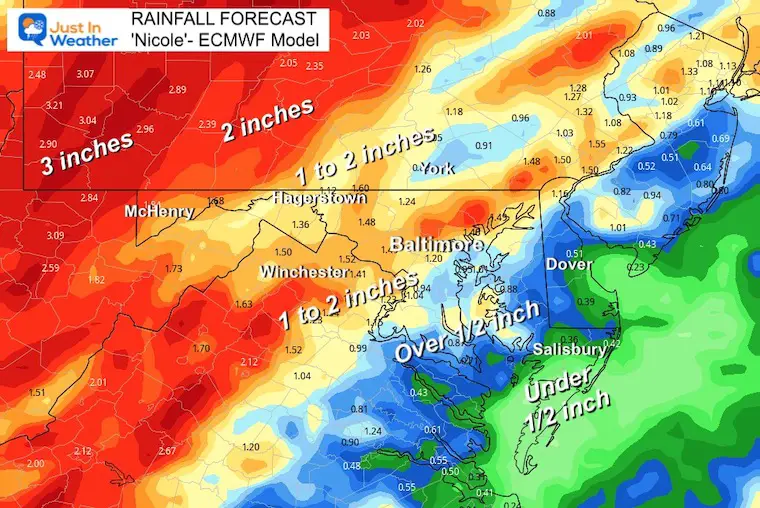
European Model
This is very similar to the GFS Model above.
Side-Note:
Sunday may bring rain showers from an upper level disturbance to follow, but it will NOT be Nicole. Overall the weekend may have more action but it will NOT be a washout.
Here the GFS Model shows that disturbance catching up with colder air and hinting at rain mixed with snow showers (blue) Sunday morning. This could happen in the mountains and higher hills of central to western Maryland. Stay turned…
7 PM Friday to 10 AM Sunday
Faith in the Flakes? I see some of that blue in Northern Baltimore and Harford Counties in Maryland. Interesting….
I will have a full update in my morning report.
NEW: November Outlook Map From NOAA Showed This For The First Time
The Big Cool Down Into Mid November: NOAA Outlook Does This For First Time
Also See: Winter Outlook Series:
Winter Outlook 2023 From NOAA Very Different Than Farmers Almanacs
ALSO, SEE THESE OTHER WINTER OUTLOOK REPORTS
Farmer’s Almanac Comparison
Winter Outlook 2023 Early Look At Snow From Two Farmers Almanacs
Triple Dip La Niña Winter
Winter Outlook 2023 La Niña Triple Dip Expectations
CONNECTION TO WINTER?
If you want a snowy winter, this is what you might want to look for in the rest of the tropical season. (You might be seeing a lot of commercial snow removal people out this Winter).
Record August For No Named Tropical Storms: Closer Look At Snow Following
Wooly Bear Caterpillars
Winter Weather Outlook From The Wooly Bear Caterpillar
Persimmon Seeds
Winter Weather Outlook: Persimmon Seeds And Snow Folklore
Click to see Top 20 and MORE
Winter Weather Folklore Top 20 And More Outlook Signals From Nature For Cold And Snow
Normals And Records: Maryland and Baltimore Climate History

Faith in the Flakes Gear

SNOWSTIX – Available Now

Please share your thoughts, best weather pics/videos, or just keep in touch via social media


