February 28 Wet Morning With Snow North Then Mild Again
February 28, 2023
Tuesday Morning
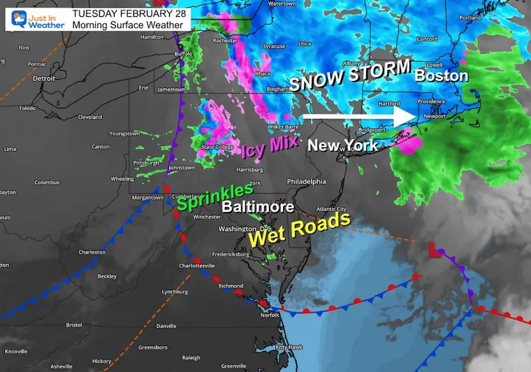
We are about to end the month of February as the warmest on record, at least in Baltimore. This month has averaged 8 degrees ABOVE average. Today is quite symbolic as there is a winter storm just to our north. So if you are traveling to metro New York or New England there is snow falling there.
Ice did fall nearby last night.
Many people reported some sleet with the precipitation on Monday afternoon, but the second band in the evening took it to the next level in York County, PA. This was mainly on the elevated decks, but surely shaking things up:
Shiloh york pa at 641 pm tonight…. All sleet with little rain mix. @bradonlongwx @MaryEllenPannWx @TonyPannWBAL @JustinWeather @DopplerDan @spann @TOMRUSSELLCBS21 @JoeCalhounWGAL pic.twitter.com/r6rq7o3ODX
— Storm Chaser Jogan Girl (@specialks01) February 28, 2023
Today we get some sprinkles on wet pavement to start the day, but dry air will develop and clear out the clouds this afternoon.
The same old thing this week: We will be mild and warmest on Thursday. That day brings rain in the morning, followed by the next close brush with winter. At this point it looks like it was wise to remain skeptical. There will be a storm, and some of our region may get snow or sleet, however it will be mainly the northern and western hills. Not much for central Maryland.
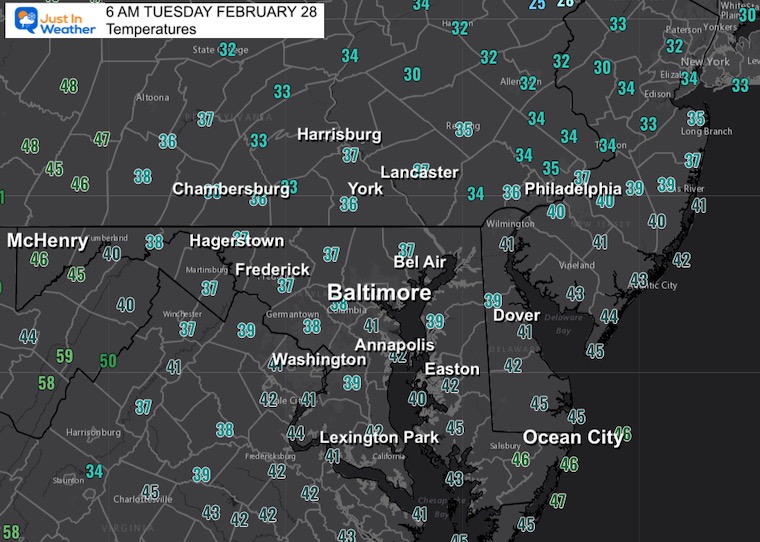
Morning Temperatures
We are safely above freezing to start today, so no worries locally.
National Weather
If you travel to central PA, you may encounter some icing around State College and north of Harrisburg on I-81 through the Poconos.
Snow has waned for metro New York, but it is still falling and will continue in the Hudson Valley through New England. This includes a snowy Connecticut to Boston, and for many their largest snowfall of the season.
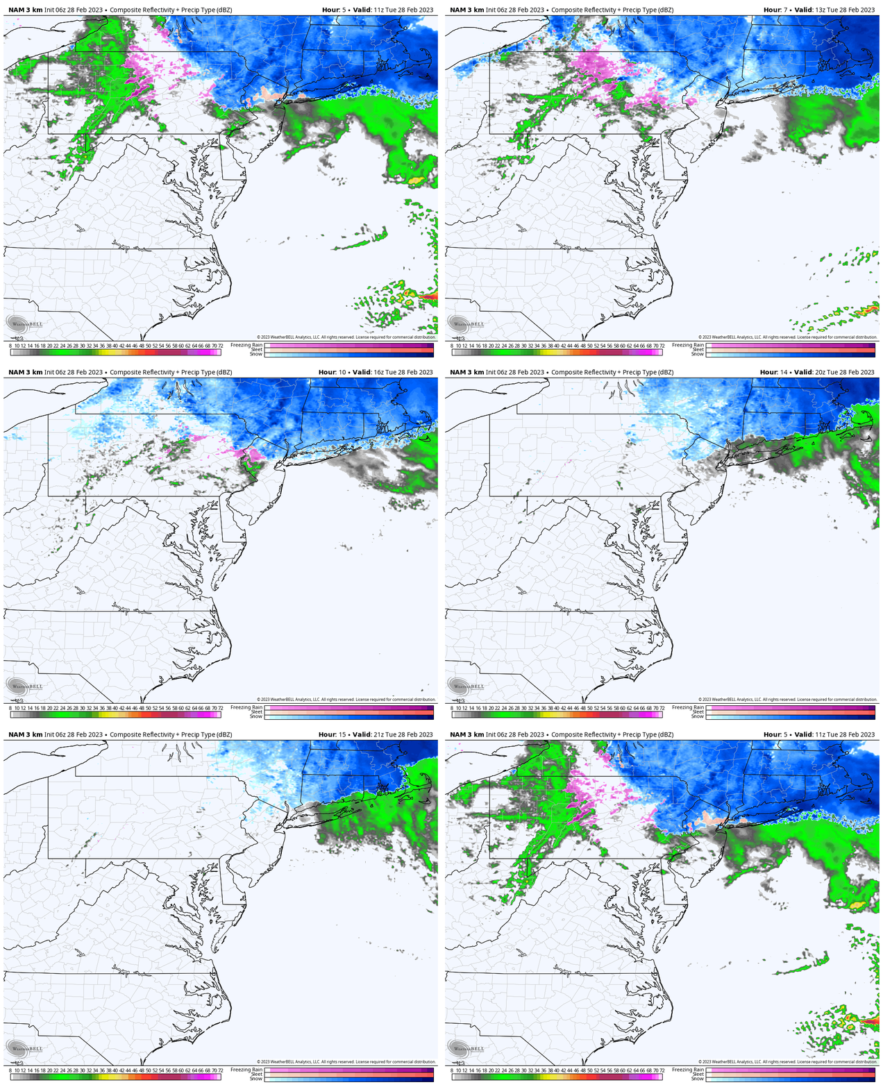
Forecast Animation Through Afternoon
Locally we may still have a few sprinkles or rain showers through midday. Traveling north, snow will continue across New England through the afternoon.
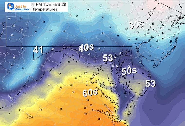
Temperatures Afternoon:
We may have some sprinkles, but more sun will help to bring on another mild day.
Subscribe for eMail Alerts
Weather posts straight to your inbox
Sign up and be the first to know!
CLIMATE DATA
TODAY February 28
Normal Low in Baltimore: 30ºF
Record 5ºF in 1934
SNOW: 5.2” in 1949
Normal High in Baltimore: 50ºF
Record 71ºF in 1903
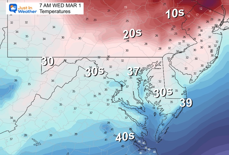
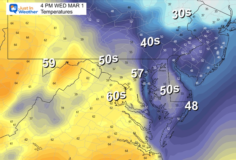
Wednesday
Morning
Afternoon
Storm Simulation:
Thursday Morning To Saturday Evening
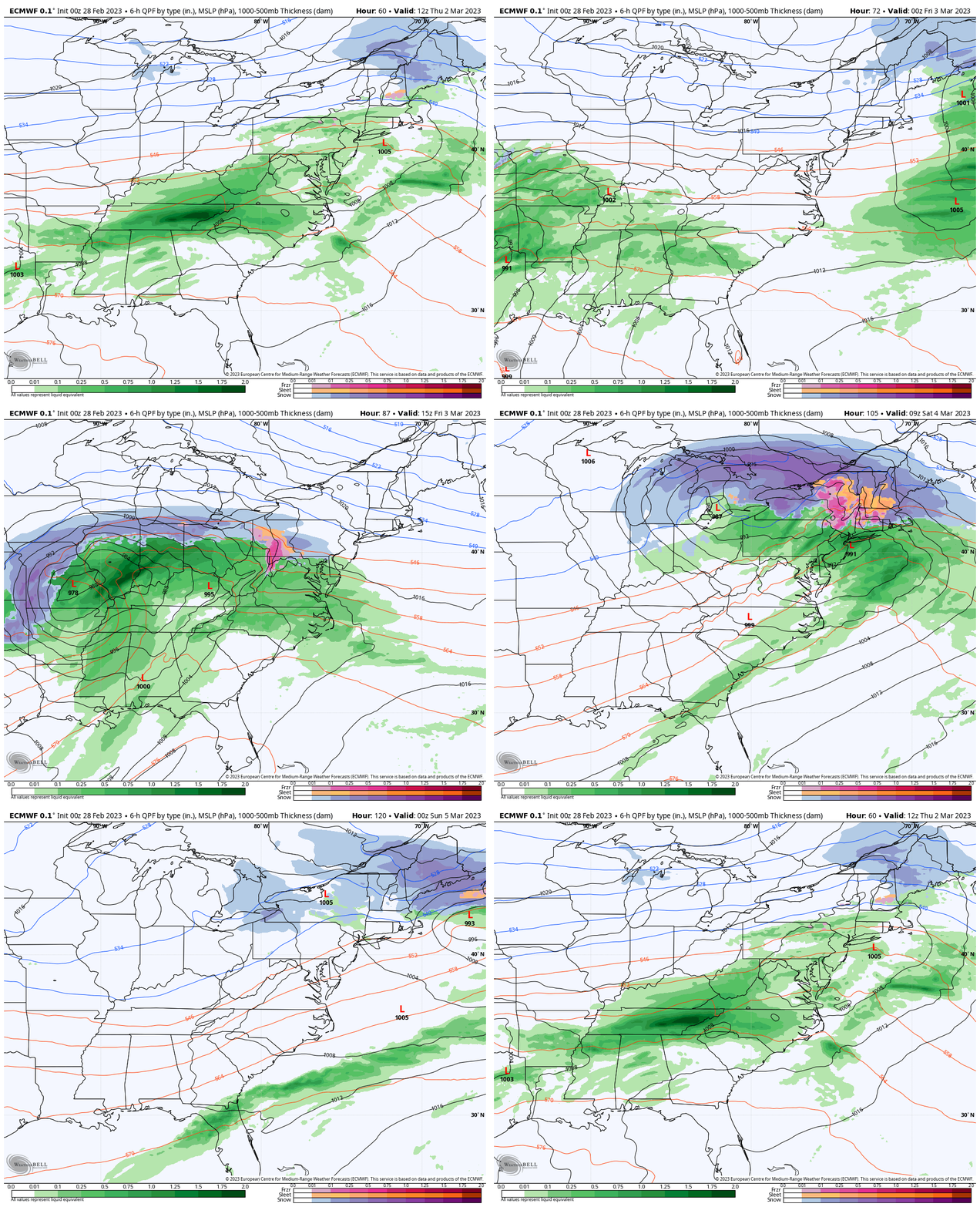
The reality is that this will be another winter storm but mostly rain for our region. Rain Thursday morning will be followed by a warmer afternoon.
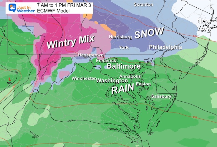
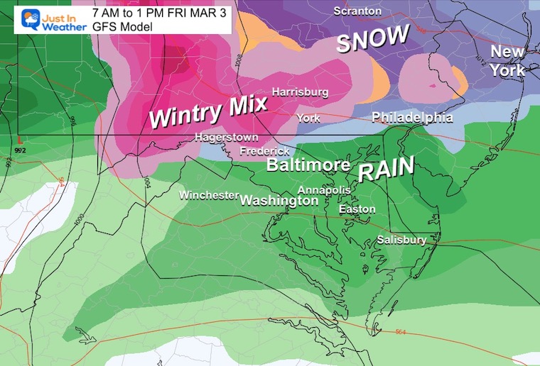
Friday: If we get this to start early enough, the snow and icy mix may lead the first few hours… but for the mountains and along the Maryland and Pennsylvania line up north.
Friday Snapshots
There is now more agreement between the European and GFS Models. There is also validation for my skepticism about a snow storm. There will be one, just not for central Maryland.
The climatological favored areas west and north of Baltimore may get a few hours of snow or sleet. This includes the mountains, northern hills near and north of the Pennsylvania line.
ECMWF Model
This looks like a marginal event that will rain for most of the Maryland population. But half of the area I cover will get in on some wintry weather near and north of the Pennsylvania line.
GFS Model
This model is now very similar to the European solution above. This adds a little more confidence, however, I suspect there will be some more adjustments as the model plots have had trouble zeroing in on winter events.
7 Day Forecast
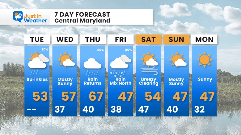
The trend continues with our warmest day on Thursday, then cooling into the weekend. This time we get rain, however will watch that Friday event for some snow or wintry mix for the northern half of our region… More likely near and north of the PA line.
Also See:
Winter History: Low Snow And Late Starts
See my research based on Baltimore data since 1883.
Subscribe for eMail Alerts
Weather posts straight to your inbox
Sign up and be the first to know!
STEM Assemblies/In School Fields Trips Are Back
Click to see more and ‘Book’ a visit to your school 
My Winter Outlook: Not A Typical La Niña!
I see many factors to support colder influence with multiple systems. Early and later in winter. Check it out. https://justinweather.com/2022/11/22/winter-outlook-2023-for-snow-not-typical-la-nina-plus-polar-vortex-disruption/
Also See The Winter Outlook Series:
Farmer’s Almanac Comparison
September Starts Meteorological Autumn: Weather Climate Stats For Maryland at Baltimore
Triple Dip La Niña Winter
https://justinweather.com/2022/09/09/winter-outlook-2023-la-nina-triple-dip-expectations/
CONNECTION TO WINTER?
If you want a snowy winter, this is what you might want to look for in the rest of the tropical season. https://justinweather.com/2022/08/31/record-august-for-no-named-tropical-storms-closer-look-at-snow-following/
Woolly Bear Caterpillars
https://justinweather.com/2022/10/25/winter-weather-outlook-from-the-wooly-bear-caterpillar/
Persimmon Seeds
Click to see Top 20 and MORE
Normals And Records: Maryland and Baltimore Climate History
Please share your thoughts, best weather pics/videos, or just keep in touch via social media
-
-
Facebook: Justin Berk, Meteorologist
-
Twitter: @JustinWeather
-
Instagram: justinweather
-


