February 25, 2023
Saturday Morning
In a normal winter, this would be a non-event. But this is not a normal winter, and we just broke a record with high temperatures in the upper 70s on Thursday. Now, two days later we have a band of light snow developing just to remind us of what winter should bring. For many this may be only the second day this winter with some snow falling. The last one was on February 1 when BWI barely broke the snow drought.
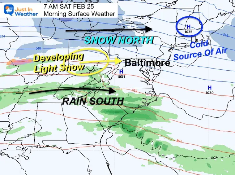
High Pressure in New England is our source for the cold air. A lot of our region has dropped to near or below freezing this morning.
The atmosphere has a split flow with snow to our north and rain to the south. There is a marginal blending or convergence region over us. That is where we expect light snow to break out.
I will show you a comparison of 3 model simulation sliders to get an idea of the agreement for the snow on the way. I leveled to include the snow total product as well. Before that I need to emphasize a few things:
- Cold air is in place, but the ground is still warm from the last few days.
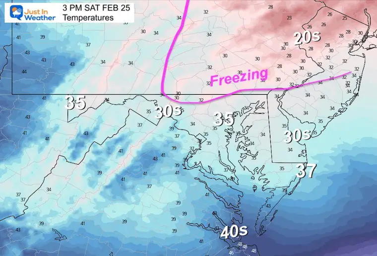
- Air temperatures will rise to the mid 30s for most areas. Some northern counties may hold near 32ºF.
- Snow will fall midday and afternoon. Plan for around lunchtime, ending by evening. This will be the peak warming and solar energy of the day.
- The net result will be melting. However, stickage may take hold ON THE GRASS with some steadier snow bands. I expect most roads will be just wet.
- The snow and mix to rain south will end this evening.
- Sunday morning may start off foggy, then clear in the afternoon as we warm again.
- Monday brings yet another rain storm for our region, with snow just north.
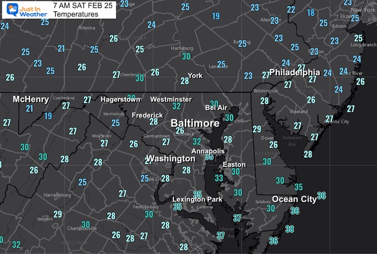
Morning Temperatures
We have set the stage for the cold reality check. However some warming ahead of the precipitation is expected by late morning and midday.
Snow Models
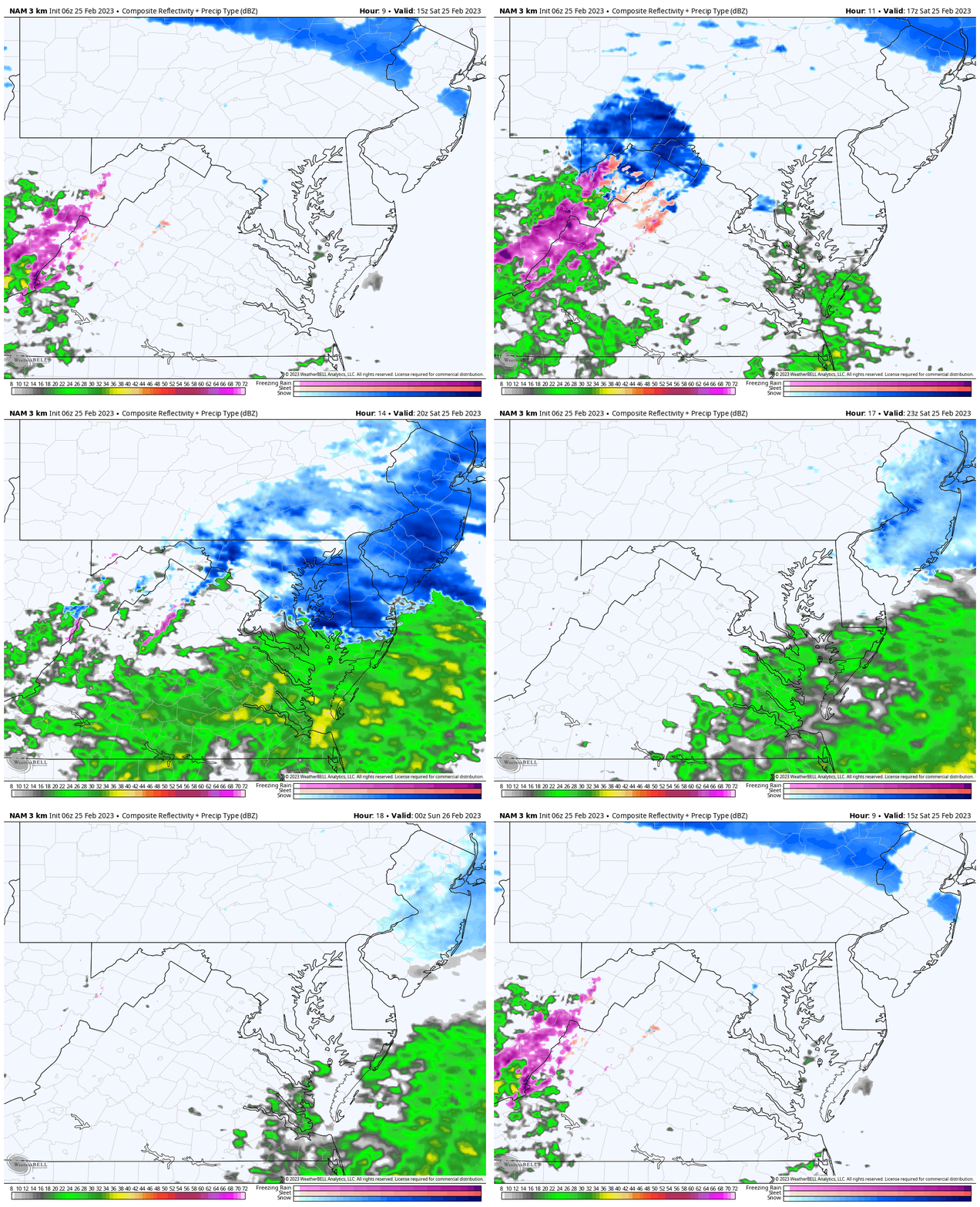
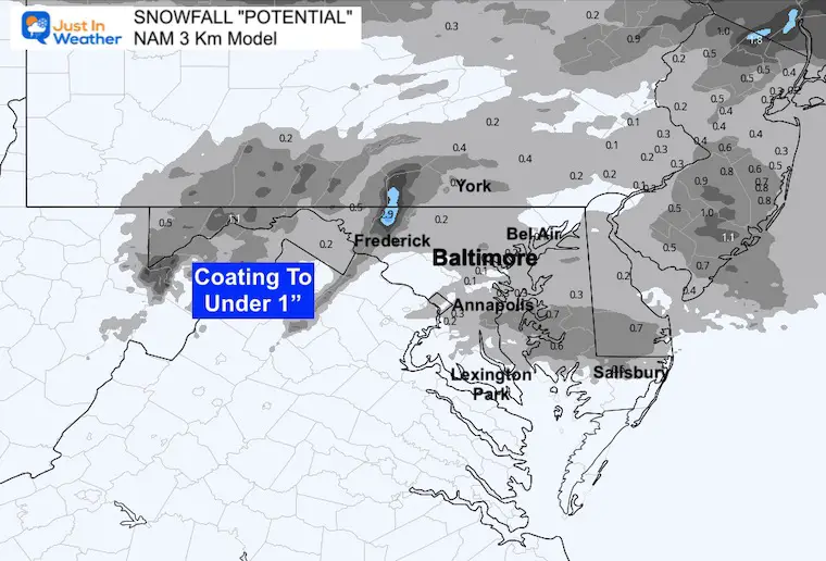
Let’s start with the High Resolution NAM 3 Km animation. Then we can look at the comparative sliders between 3 KM, European ECMWF, and GFS.
Animation: 10 AM to 7 PM
Note, this model has a tendency to be display 1 to 2 hours slower than verified.
Slider —->
Again, we may expect the snow to arrive 1 to 2 hours earlier than shown here.
Snowfall Potential
This product suggests a coating to under 1 inch.
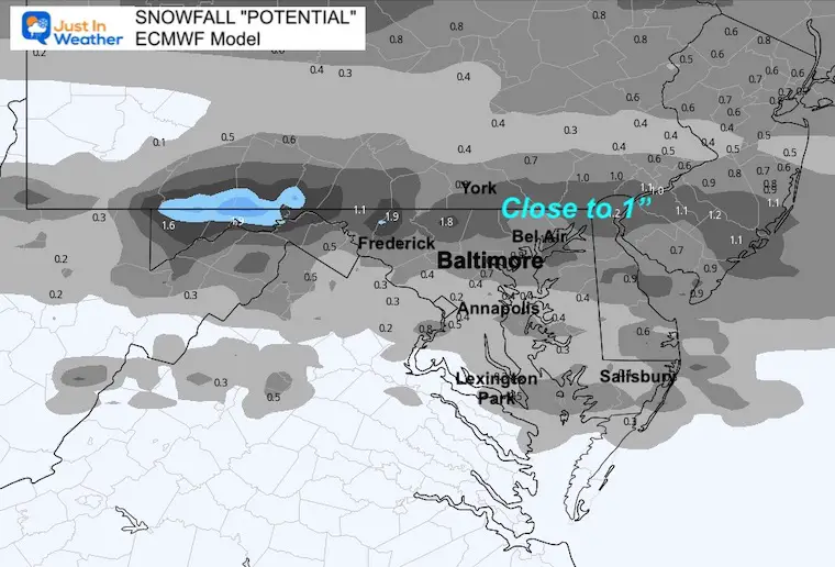
European ECMWF Model —> slider
Snowfall Potential
This product suggests
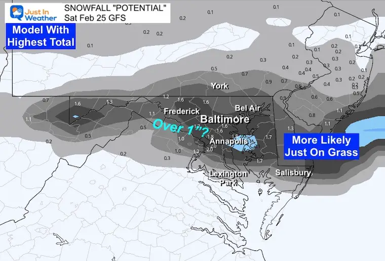
GFS Model —> slider
Snowfall Potential
This product suggests
Temperatures
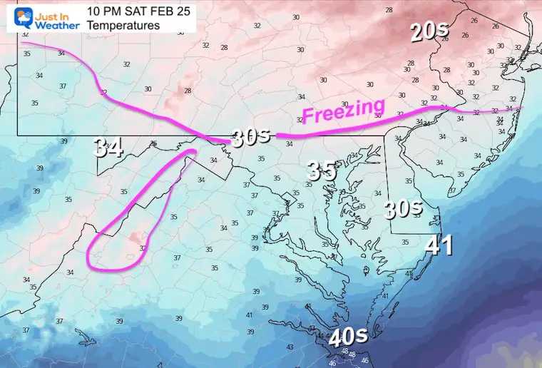
Afternoon:
Temps will be close to freezing in the northern areas around the MD/PA Line. This may support more stickage.
Notice the mid 30s in central Maryland and Delmarva. That is why roads are likely to rain wet.
Tonight
Not much cooling after the snow ends, so the concern for icing is minimal if you have plans to go out. This may be different in the morning.
Subscribe for eMail Alerts
Weather posts straight to your inbox
Sign up and be the first to know!
CLIMATE DATA
TODAY February 25
Normal Low in Baltimore: 29ºF
Record 8ºF in 1914
SNOW: 5” in 1934
Normal High in Baltimore: 49ºF
Record 83ºF in 1930 *THE HOTTEST FEB TEMP ON RECORD FOR BALTIMORE
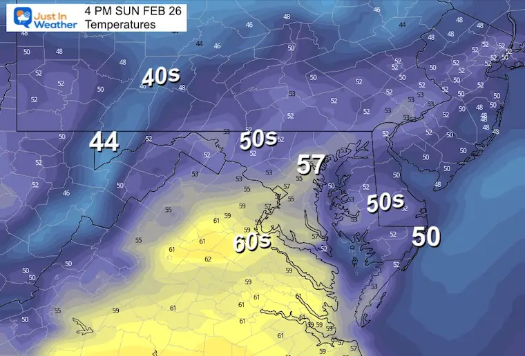
Sunday Weather
There may be some morning fog, then we will get into clearing and mild temps in the afternoon.
Temperatures
Morning
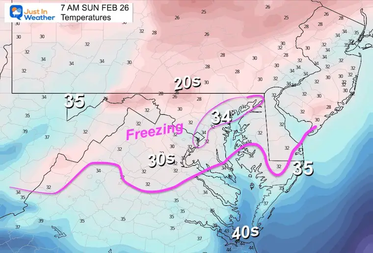
Afternoon
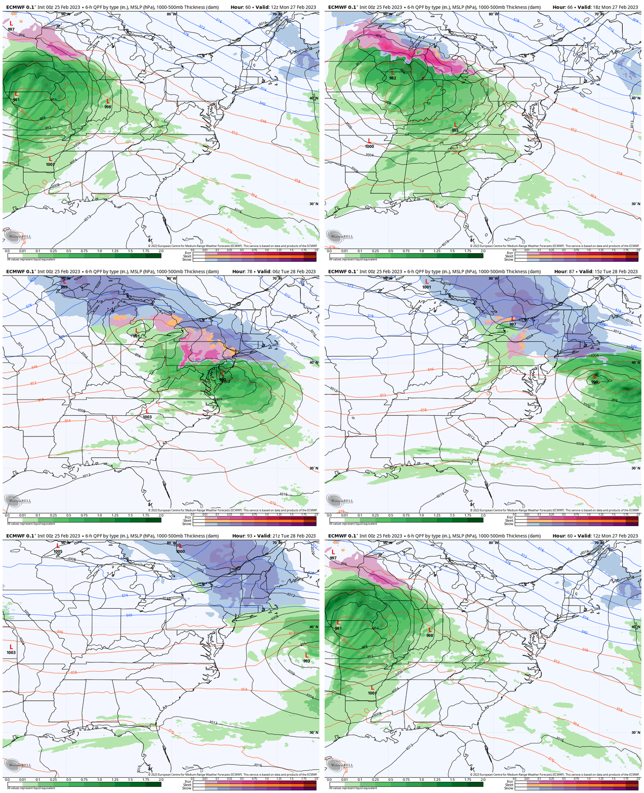
Monday: Next Storm
The system that is bringing Blizzard Conditions to Southern California will reach the Great Lakes and once again keep us on the warmer side. This will be another rain event for us. Some wintry mix at the start in central PA.
Radar Simulation:
Monday Morning To Tuesday Afternoon
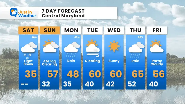
7 Day Forecast
After today’s winter blip, we turn the tables again.
The pattern repeats with a rain storm, then warm. There is a significant change on the way, but after this coming week.
Also See:
Winter History: Low Snow And Late Starts
See my research based on Baltimore data since 1883.
Subscribe for eMail Alerts
Weather posts straight to your inbox
Sign up and be the first to know!
STEM Assemblies/In School Fields Trips Are Back
Click to see more and ‘Book’ a visit to your school 
My Winter Outlook: Not A Typical La Niña!
I see many factors to support colder influence with multiple systems. Early and later in winter. Check it out. https://justinweather.com/2022/11/22/winter-outlook-2023-for-snow-not-typical-la-nina-plus-polar-vortex-disruption/
Also See The Winter Outlook Series:
Farmer’s Almanac Comparison
September Starts Meteorological Autumn: Weather Climate Stats For Maryland at Baltimore
Triple Dip La Niña Winter
https://justinweather.com/2022/09/09/winter-outlook-2023-la-nina-triple-dip-expectations/
CONNECTION TO WINTER?
If you want a snowy winter, this is what you might want to look for in the rest of the tropical season. https://justinweather.com/2022/08/31/record-august-for-no-named-tropical-storms-closer-look-at-snow-following/
Woolly Bear Caterpillars
https://justinweather.com/2022/10/25/winter-weather-outlook-from-the-wooly-bear-caterpillar/
Persimmon Seeds
Click to see Top 20 and MORE
Normals And Records: Maryland and Baltimore Climate History
Please share your thoughts, best weather pics/videos, or just keep in touch via social media
-
-
Facebook: Justin Berk, Meteorologist
-
Twitter: @JustinWeather
-
Instagram: justinweather
-


