January 18 2023
Wednesday Morning Report
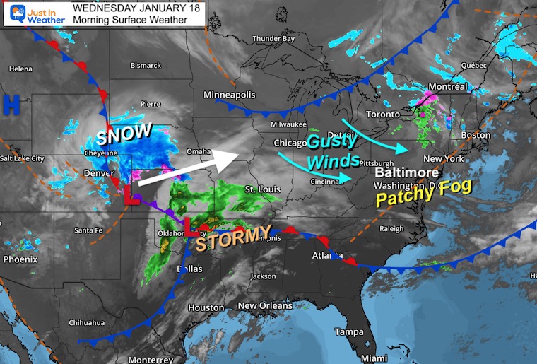
A bit of rain passed through overnight, adding to the moisture and some pockets of fog. The thicker fog appears to be around I-95, north and south of Baltimore.
Gusty winds today will keep us mild, but a cooler trend is on the way. That will start with rain tomorrow, then we watch a little more wintry ‘stuff’ mixing in with the next two follow up events.
Headlines
- Today: Patchy Early Fog, Gusty Winds Develop
- Thursday: Rainy, Heavy In The Evening
- Next Two Storms: Tracking South, Snow A Little Closer
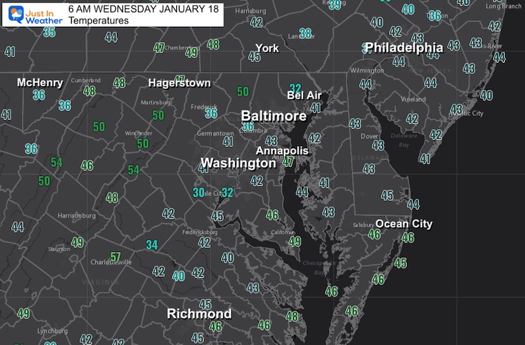
Morning Temperatures
No part of the region is below freezing this morning.
Morning Surface Weather
Patchy fog around I-95 this morning. Gusty winds will be building in and helping to dry us out today.
The snow moving out of the Colorado Rockies will track into the north central plains then the Great Lakes. Another round of severe storms in the south as that will be our rain maker tomorrow.
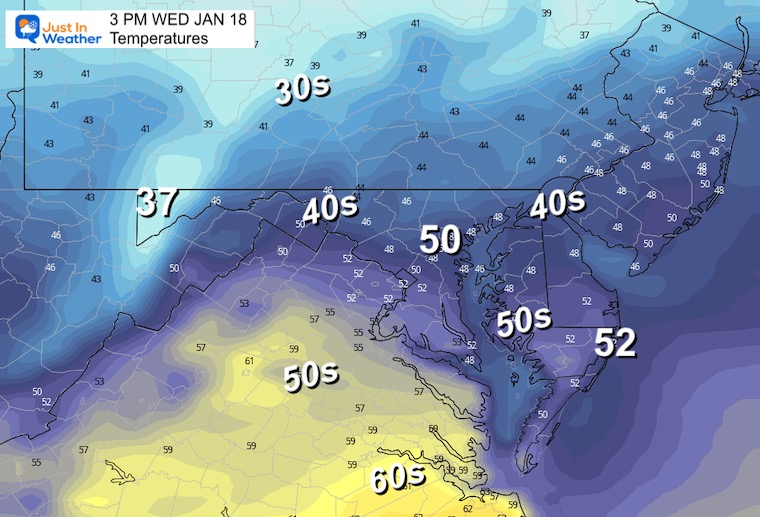
3 PM Temperatures
Mild but gusty winds.
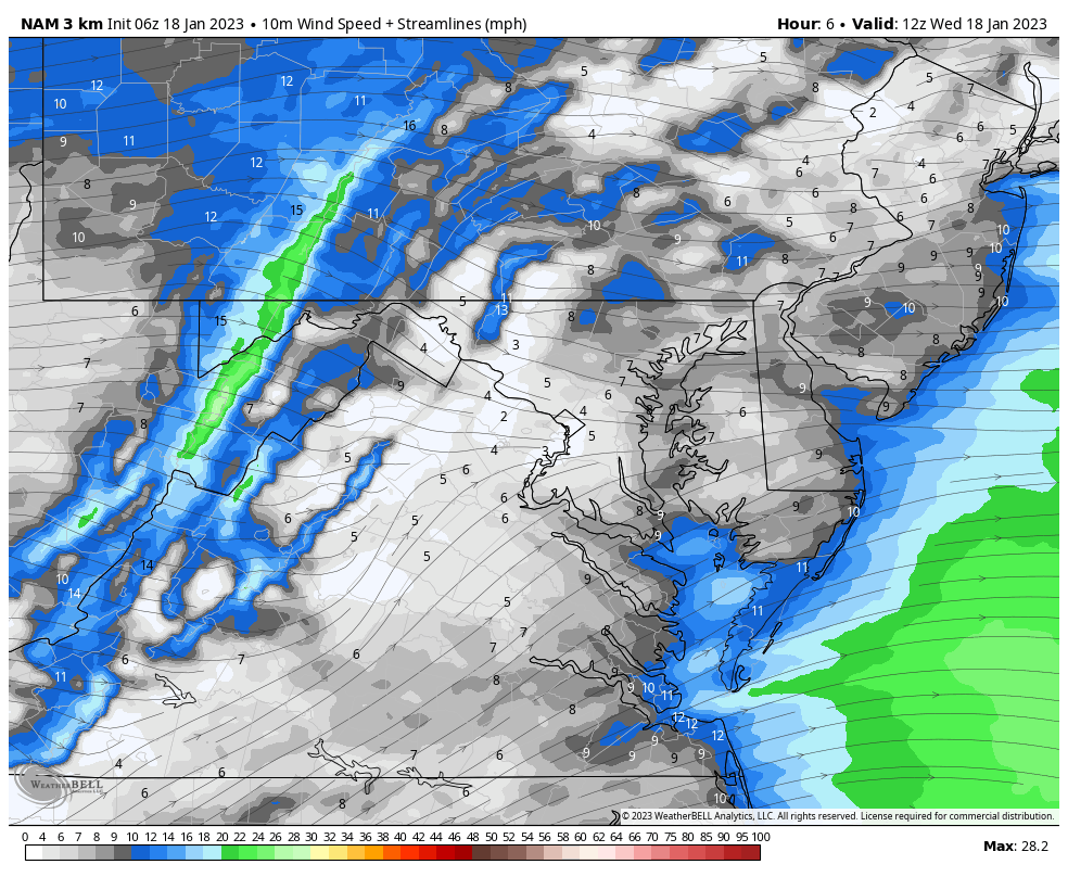
Wind Forecast: 7 AM to 7 PM
Winds will increase from the Northwest between 10 to 20 mph, with gusts up to 30 mph.
Subscribe for eMail Alerts
CLIMATE DATA
TODAY January 18
Normal Low in Baltimore: 26ºF
Record -4ºF in 1957
SNOW: 4.6” 1984
Normal High in Baltimore: 43ºF
Record 68ºF 1990
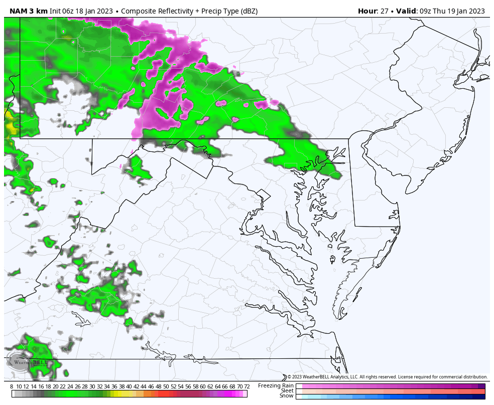
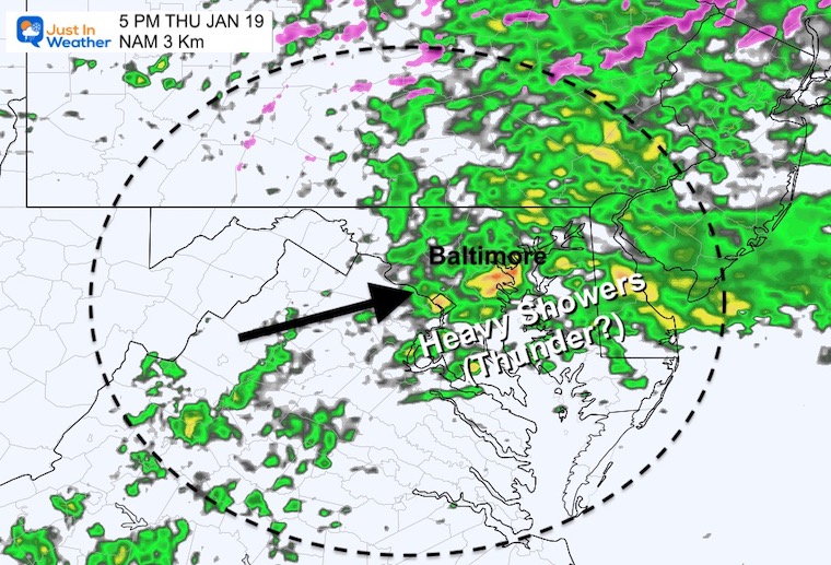
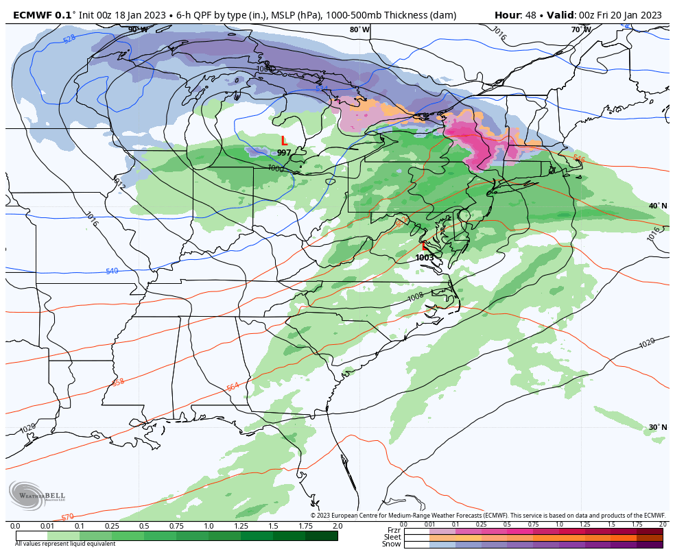
Thursday
Radar Simulation:
HRRR Model 4 AM to 8 PM
Snapshot Thursday Evening
The heaviest rain will arrive with the back edge of this system. There may be some pockets of lightning and thunder.
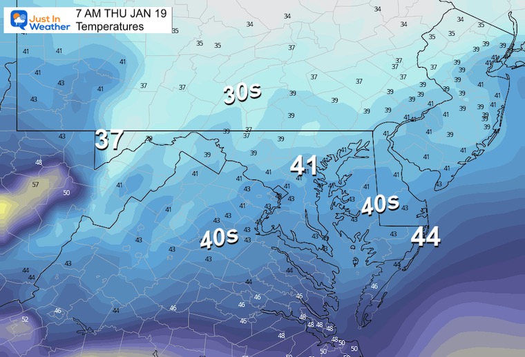
Morning Temperatures
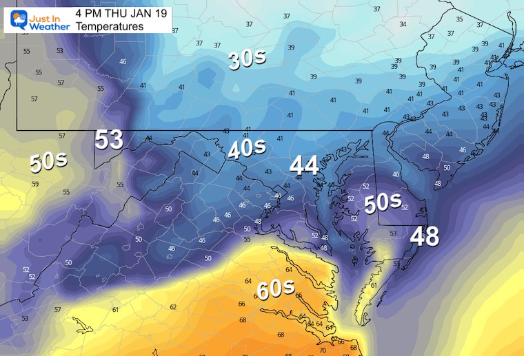
Afternoon Temperatures
Storm Simulation
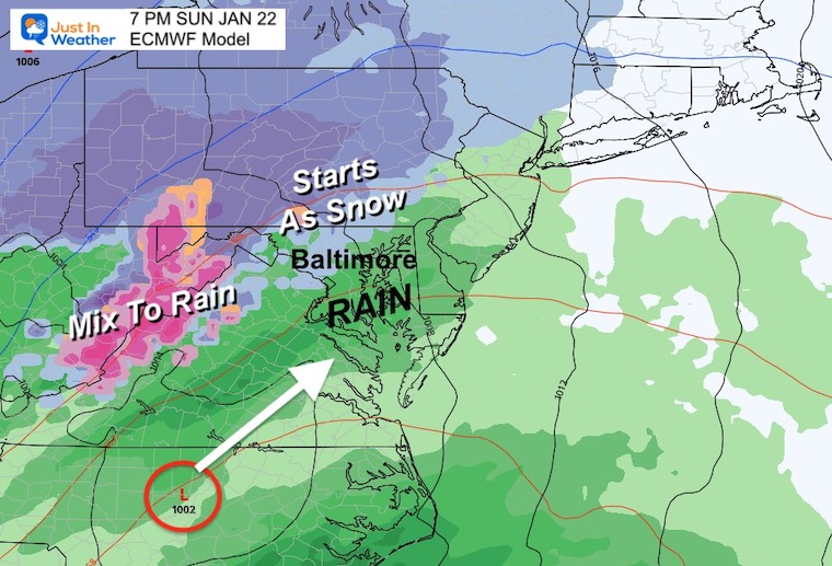
ECMWF Model 7 PM THU to 7 AM MON
The European Model has been steady in the transition with a shift of storm track. We are missing arctic air, but the southern push of storms will allow for a little more wintry weather closer to home.
This is a signal of a change as the atmosphere is trying.
Snapshot: Sunday Evening
This looks like it will start with some wintry mix, especially inland. At this point it looks like the warm ground and marginal temps will not support stickage. Just local roads will be wet.
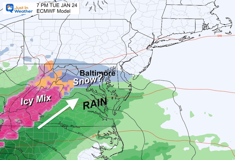
Snapshot: Next Tuesday
The next storm system will have colder air and perhaps a little more snow at the start. Just keeping this on the docket in our look at the week ahead.
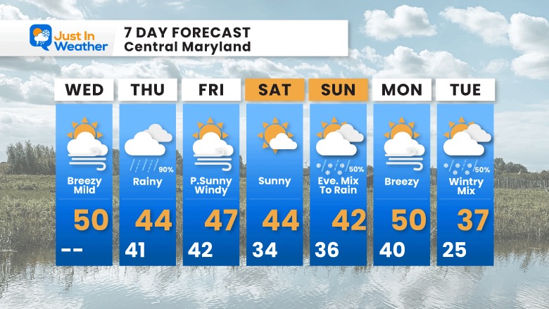
7 Day Forecast
Temperatures drop to near seasonal levels. The pattern change is the storm track. No true arctic air, yet… But we see a change in the storm track to introduce some wintry mix. That will be more likely west and north of Baltimore.
Faith in the Flakes Gear

What is Faith in the Flakes?
It began with my son in 2009
October 27 Nor’easter Recap Still Breezy Then Next Storm Friday
SNOWSTIX – Available Now

STEM Assemblies/In School Fields Trips Are Back
Click to see more and ‘Book’ a visit to your school

My Winter Outlook: Not A Typical La Niña!
I see many factors to support colder influence with multiple systems. Early and later in winter. Check it out.
October 27 Nor’easter Recap Still Breezy Then Next Storm Friday
Also See The Winter Outlook Series:
October 27 Nor’easter Recap Still Breezy Then Next Storm Friday
Winter Outlook 2023 La Niña Triple Dip Expectations
Farmer’s Almanac Comparison
September Starts Meteorological Autumn: Weather Climate Stats For Maryland at Baltimore
Triple Dip La Niña Winter
Winter Outlook 2023 La Niña Triple Dip Expectations
CONNECTION TO WINTER?
If you want a snowy winter, this is what you might want to look for in the rest of the tropical season. (You might be seeing a lot of commercial snow removal people out this Winter).
Rainbow Ice Cave In Mt. Rainier A Very Rare Find: Photos And Video
Wooly Bear Caterpillars
https://justinweather.com/2022/10/25/winter-weather-outlook-from-the-wooly-bear-caterpillar/
Persimmon Seeds
Winter Weather Outlook: Persimmon Seeds And Snow Folklore
Click to see Top 20 and MORE
Winter Weather Folklore Top 20 And More Outlook Signals From Nature For Cold And Snow
Normals And Records: Maryland and Baltimore Climate History

Please share your thoughts, best weather pics/videos, or just keep in touch via social media


