


January 2 Weather Still Cold This Weekend With A Warm Up Next Week
Friday, January 2, 2026 After the New Year's Day Morning Snow Squall, the cold air mass has been firmly in place. One more system passed through overnight with flurries and…
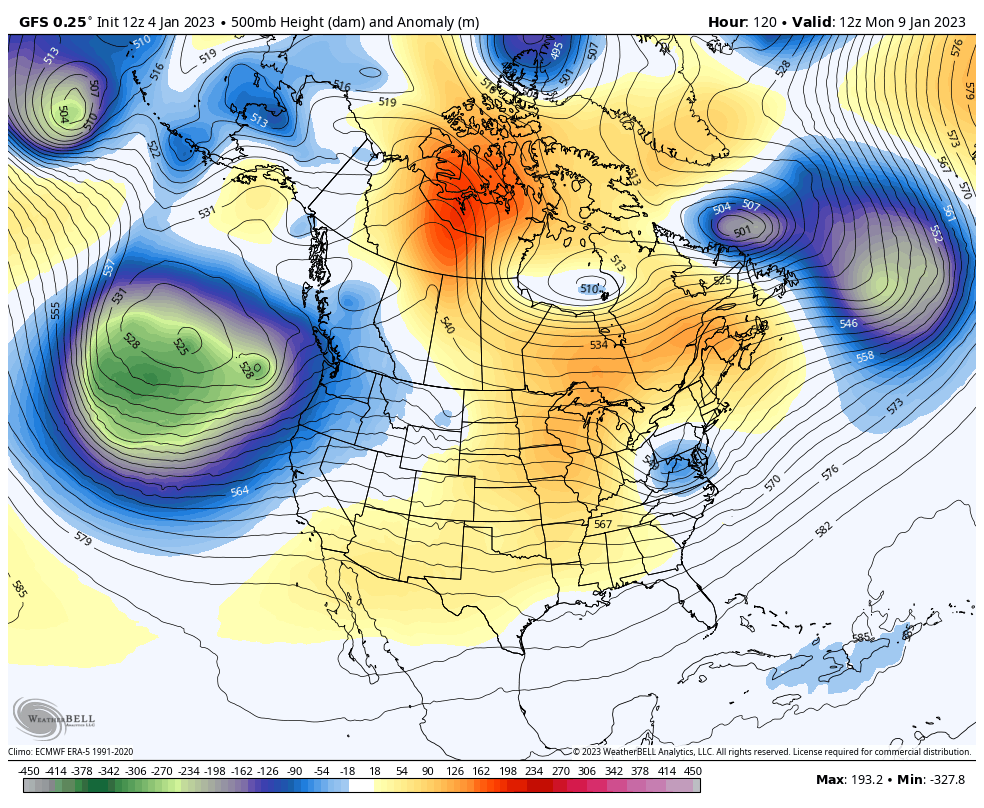
Wednesday Evening January 4 2023
I want to confess that I just picked up my new snowboard today, mounted with new bindings. I am ready to hit the powder with my son. I literally have a leg in the game, which is one of the reasons I post these outlooks for snow. I do want snow. It is why I studied meteorology and vital to my winter mental health.
The other is that I realize this very warm air seems like there will be no winter. I have heard that feeling from many people. We have had this before, quite a few times. This is my business and I pay close attention to patterns that repeat.
Yesterday, January 3, we broke the record high temperature set in 2000. Today, January 4, the record high was 70ºF in Baltimore set in that same year. It was followed by 3 snow storms between January 20 and 30 that year. Two of them were record snowfalls for those dates still on the books.
That was among the few years I discussed in a report last week. Extremes have happened before in winter, and we may very well see it again.
Also: 8 of the top 10 snowstorms in Baltimore have occurred between late January and February.
I study the patterns and interactions of global weather systems. These help to anticipate trends but I can’t, nor can anyone, project with precision winter events more than 5 or 7 days away. We are at the whim of a few computer models using the math and physics to calculate how it will play out.
Over the last few days, and many years prior, I have shown model ‘trends’ and even flips.
I will once again highlight the latest here, and in this report include some statements from other meteorologists who are seeing the same thing as me.
For the record, I am NOT on any supermarket payroll. I can’t speak for the others. HaHa!
‘Something’ is going to try.
This thing has wavered with days and intensity, and now the GFS is still overplaying and the ECMWF Model is minimizing. I do not expect much from this, and I hope I have made that clear with my recent reports.
It does signal that the atmosphere can both produce snow within a warm pattern (like we saw in January 2016), but also there is more on the way.
We see a shortwave expanding precipitation in the afternoon to evening. The leading edge has snow, with a mix trending to rain on the tail end Monday morning.
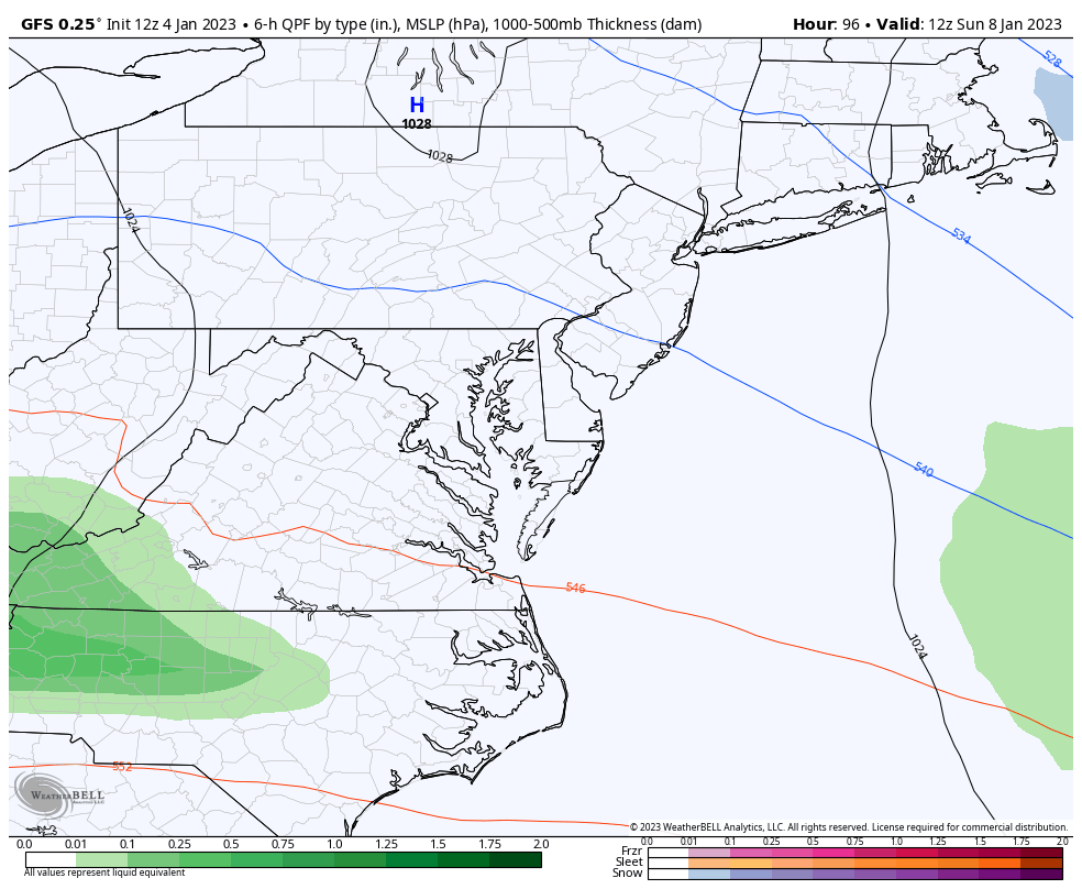
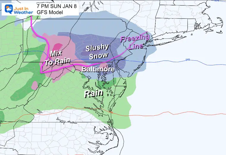
The GFS Model plot does look impressive with moderate snow (dark blue). I’ve overlaid the Freezing Line and need to reiterate this caveat: The ground is still warm after this week. So, stickage on the roads will be limited and maybe restricted to the higher elevations.
No specifics for now. This is simply for the trend and timing later on Sunday.
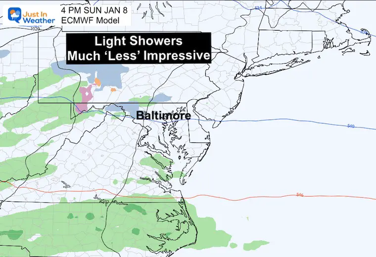
The ECMWF Model is much less impressive. While it has some light and spotty showers in the afternoon, this appears to be a forgettable event.
There is so much to discuss but I don’t want to lose you. Before I show more model plots with the Polar Vortex and Jet Stream, let’s hear from other meteorologists:
Meteorologist at Fox 5 seems to know his stuff and I often see him posting things I am looking at as well. So, let’s give him the microphone.
Pattern update: watching three windows…
1) SUN-MON: Weak energy, has 50/50 low but limited cold. Minor event at best.
2) TUE-WED: Energy disconnect. 50/50 lacking. Ridge is nice. Monitoring trends.
3) FRI-SAT: Pieces on the table, but pattern shifts are needed for a storm. pic.twitter.com/wGFEdC0wFN
— Mike Thomas (@MikeTFox5) January 4, 2023
Mike does acknowledge that pieces are on the table… I would also add that the farther out we go, the less confidence in the plots. So not seeing storm for us beyond one week could very well trend our way. This is in part to the speed error I have been showing with our short range modeling. Also, a trend for long range storm plots to verify farther west…. So something too far off the coast may end up on top of us if it can come together.
Meteorologist at WBAL in Baltimore. You may already know we are good friends, and he is the conductor of the Snow Train. But he is a good forecaster and is very aware of the global circulation connected to the MJO.
Baltimore still in the game for a little snow this weekend. Probably Sunday. The chance for a significant snow event goes up next week. MJO will move into Phase 8. 👇 “Normal” cold can make snow in January! I will be out of town, so it’s a slam dunk forecast. 😁 Stay tuned. ❄️🚂 pic.twitter.com/HV6qafhIrU
— Tony Pann (@TonyPannWBAL) January 4, 2023
Arctic Research Specialist on the Polar Vortex is leaning in on winter returning for the Eastern US.
“To reflect/stretch or absorb/SSW that is the question” for the #polarvortex (PV). I’ve been dumbfounded for weeks but I think I finally figured it out. I discuss what to expect for the PV & the weather impacts possibly thru end of winter. Blog now public: https://t.co/Gg8N2KIjJS pic.twitter.com/Xdmk6HXnlb
— Judah Cohen (@judah47) January 4, 2023
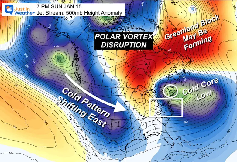
I am violating my own protocol for one purpose: This is not a forecast, rather to show how the atmosphere will continue to be active. A lot of attention has rightly been on the west coast. That energy will continue to flow. Now imagine that with a colder jet stream over the Eastern US…
Please do not focus on the tracks and timing. Definitely NOT that major event on the last time frame for January 16.
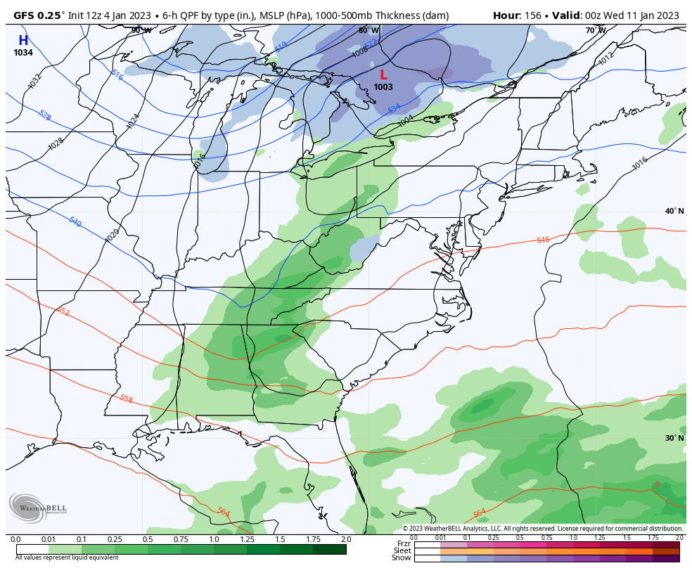
After this weekends little blip, that next system Mike mentioned will try to develop on Wednesday January 11, then another short wave on Saturday January 14.
Beyond that, we see what may be that pattern change I have been advertising showing up during the week of January 16….
Greenland Block forming will send the North Atlantic Oscillation back to NEGATIVE.
Pacific (PNA) remains positive – That stormy weather shifts the Colder Pattern East!
These are numbers for Baltimore at BWI. Inland suburbs will be colder.
This is from the GFS this morning. If you look at models to compare, this is the 12Z run. I NEVER use an off hour (06Z or 18Z) for long range, as they are not dealing with a full suite of upper air data.
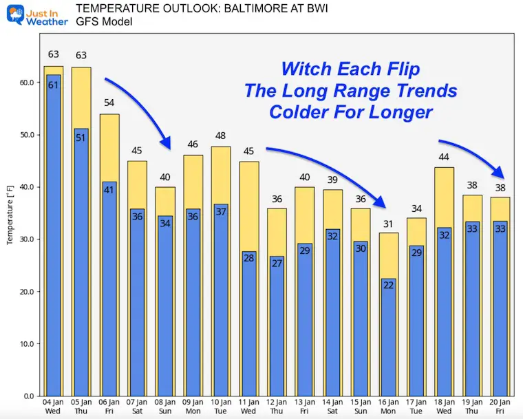
This model has been flipping from cold to mild, then to colder. It is having trouble handling the pattern change, but keeps going back to it. That is one reason I believe it will continue to trend that way.
I wrote in my winter outlook that I expected a mild start to January with a colder trend to end the month and take us to February. I still see a lot of support for that and my Faith in the Flakes is in full force!
FITF
Sign up and be the first to know!

October 27 Nor’easter Recap Still Breezy Then Next Storm Friday

Click to see more and ‘Book’ a visit to your school

I see many factors to support colder influence with multiple systems. Early and later in winter. Check it out.
October 27 Nor’easter Recap Still Breezy Then Next Storm Friday
October 27 Nor’easter Recap Still Breezy Then Next Storm Friday
September Starts Meteorological Autumn: Weather Climate Stats For Maryland at Baltimore
If you want a snowy winter, this is what you might want to look for in the rest of the tropical season. (You might be seeing a lot of commercial snow removal people out this Winter).
Rainbow Ice Cave In Mt. Rainier A Very Rare Find: Photos And Video
https://justinweather.com/2022/10/25/winter-weather-outlook-from-the-wooly-bear-caterpillar/
Winter Weather Folklore Top 20 And More Outlook Signals From Nature For Cold And Snow
