Arctic Air Makes A Move Next Week Starting With A Winter Event
Friday Evening Update December 9 2022
As we enter the middle of winter, the expected pattern change is starting to take form. The first part is here now, and may not seem that dramatic. Temps have chilled and we will be slightly below average this weekend and into next week.
Earlier I posted the new outlook for La Niña ending. That was focused on the last half of winter. Let’s stick with the here and now.
If you are a skeptic, I get it. Starting last weekend, I showed you a collection of computer models trying to bring in some snow this weekend. As the week progressed, there was an ebb and flow, with an eventual vanishing of the weather event. I have been skeptical as well. Computer model guidance often has a challenge at the start of the winter season locking in on multiple moving targets to time out a developing storm many days ahead of it.
Due to low confidence, that is why I purposely did NOT lead with the winter storm images. However, I have higher confidence in Greenland Block in the North Atlantic leading to a -NAO and eventual Polar Vortex disruption. This will adjust the jet stream and unload arctic air before Christmas. Check this out:
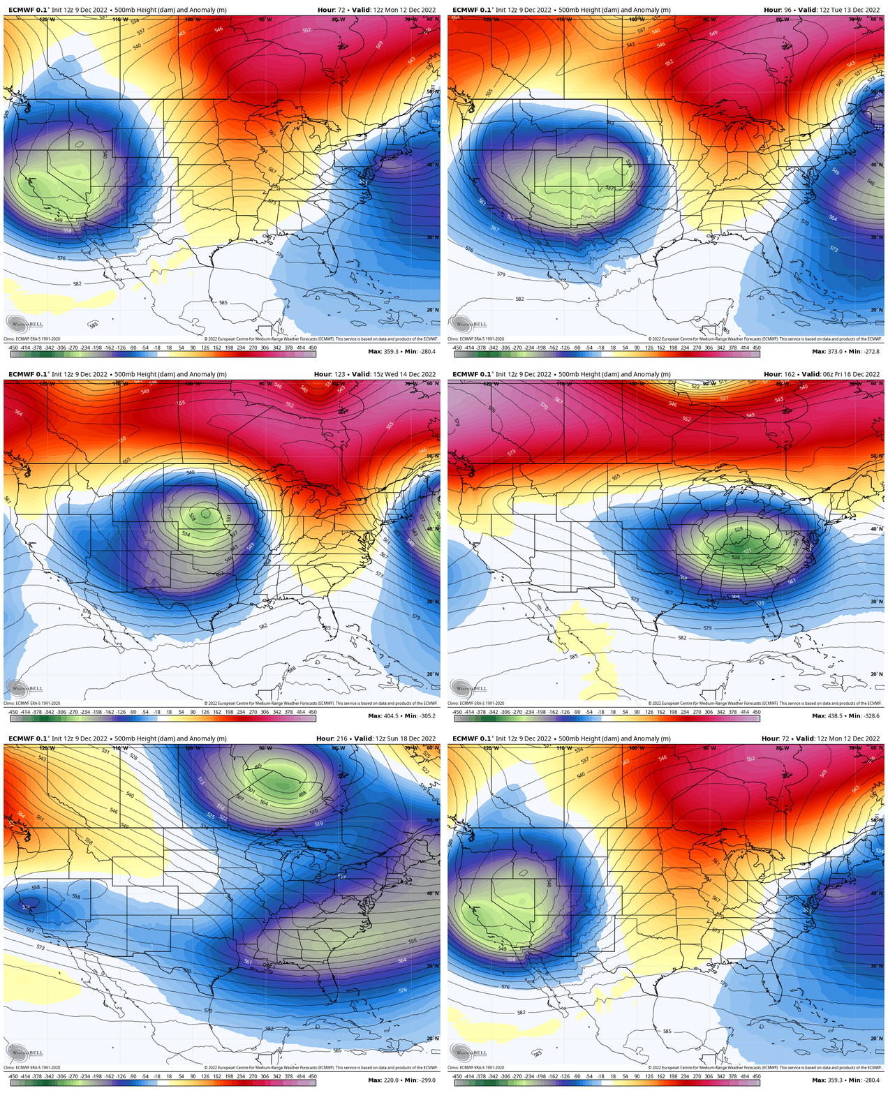
Jet Stream: Monday Dec 12 to Monday Dec 19
European ECMWF Model
- Blue and Green = Colder Air Mass
Notice the profound shift to colder air for most of the northern hemisphere next weekend. In this case between Saturday December 17 and Monday December 19 the gates ‘should’ open for an arctic intrusion.
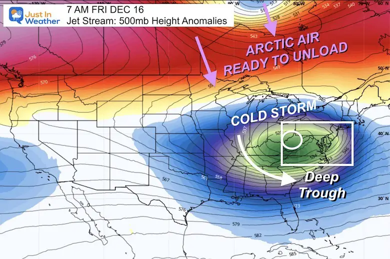
Snapshot: Friday Morning
This is the representation of the air at 500mb, or around 18,000 Ft aloft. This trough of cold air in the east will be with a storm system that is the game changer.
The upper air pattern is easier to spot than the surface weather. That is why the storm that forms underneath, is less certain at this time.
Surface Storm Plotting:
“Reluctantly crouched at the starting line. Engines pumping, and thumping with time.” – The Distance by Cake
This seemed appropriate as the race is on again for which of the main 3 computer models can best determine how this will play out.
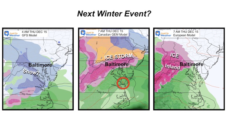
Model Comparison
Image above based on Friday Dec 9 runs
The GFS (right) was showing light snow, while both the Canadian (center) and European (left) Models are bringing in freezing rain. This is a function of the depth of the cold air and how far east it will reach ahead of that storm.
I will show all three animations below with one caveat: I don’t trust any of them until they prove themselves!
To be honest, the Canadian actually was the first model to dismiss the snow for this evening, plus it performs BEST in arctic air patterns. I will give this the lead out of the gate, but truthfully would not lock in on specifics until the Sunday night package and the trends we see develop by then.
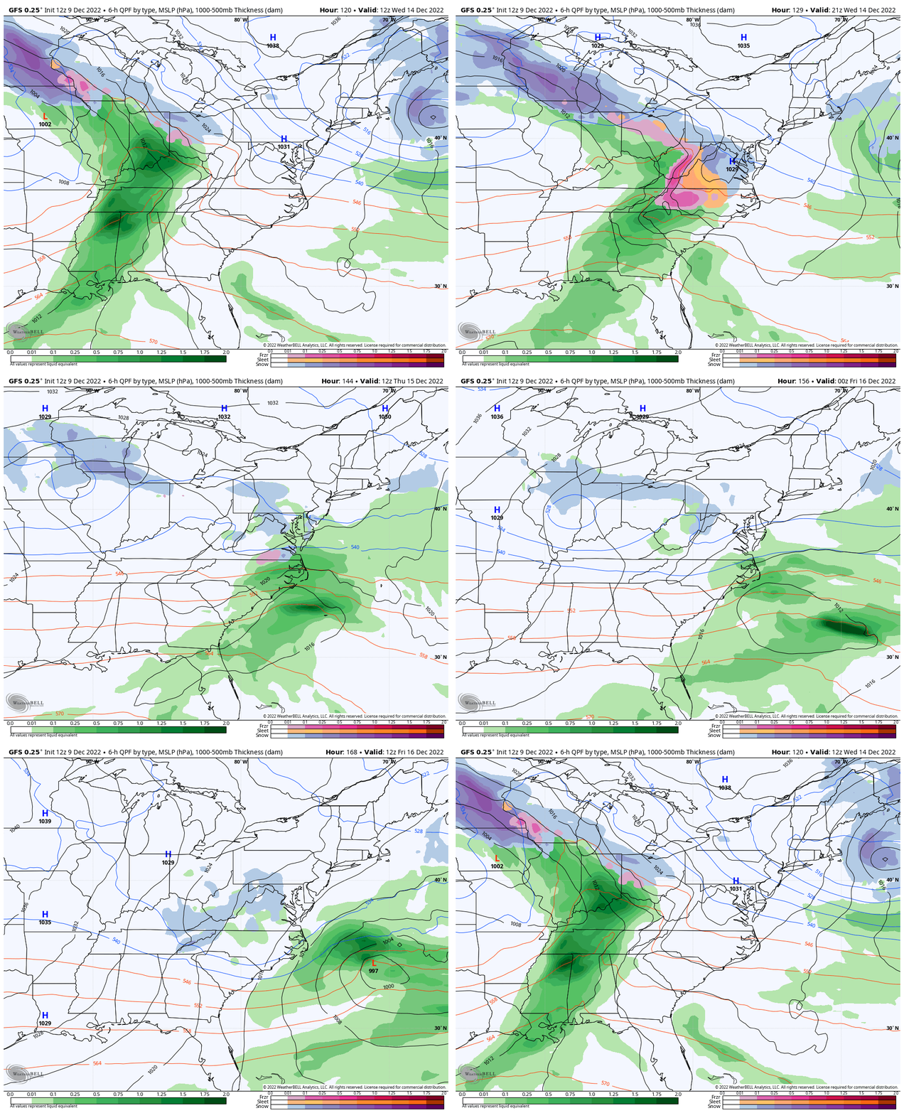
GFS Model Animation
Wednesday Morning to Friday Morning
This is the American Model prone to flip flopping. So I can’t bet on the snow, even if it’s light, at this time.
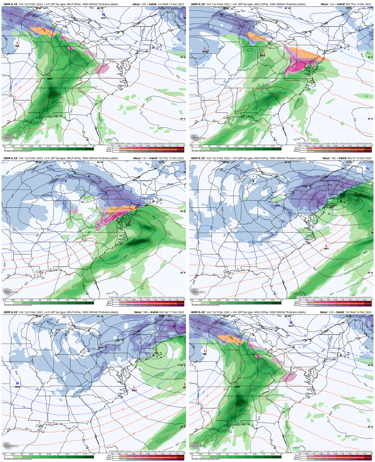
Canadian GEM Model
Wednesday Morning to Friday Evening
This shows the most robust icing event through Friday, with a stronger Surface Low affecting New England with a moderate snow event.
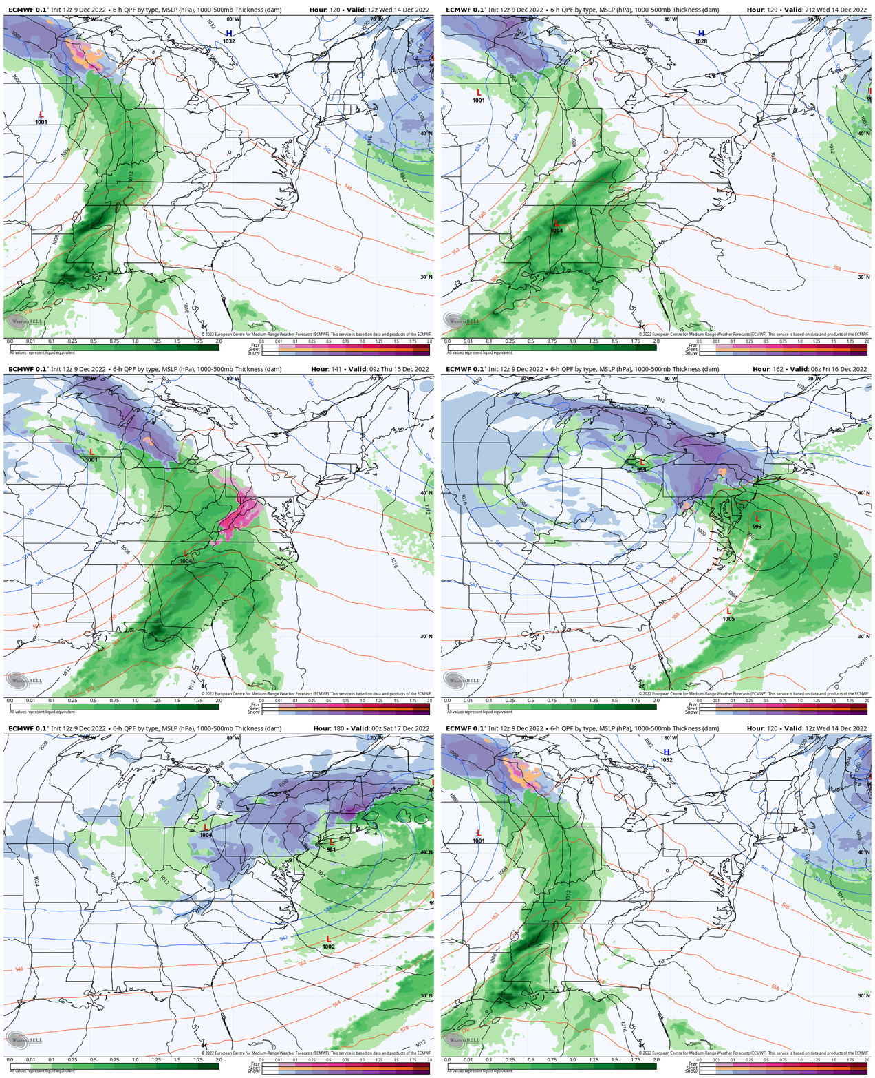
European ECMWF Model
Wednesday Morning to Friday Evening
This is similar to the Canadian, but keeps the bulk of the icing west/north of Baltimore. It also pursues a stronger surface Low and moderate snow event for New England on Friday.
My Thoughts
The model comparison I showed last week was an exercise I do every winter. I wanted to show how storm plots can change from one week away each day. Knowing the pattern will change within a period of time is the easy part. Lining up all of the elements to timing them together to form a storm with accuracy, continues to be difficult.
That is the challenge of the chaos theory. A subtle change early in timing or intensity of an element, can dramatically change the end result. The reason why the models are different are because they handle elements and information differently further out in time. One reason I know the Canadian performs at its best in colder, arctic patterns. But that still does not render it perfect.
The accuracy of the Canadian Model and the new GFS Model upgrade are still yet to be proven in this current pattern.
So as you read other blogs or check your weather app for a snowflake to pop up, please consider that there is still a lot of uncertainty. I will continue to show what I see and trends as I zero in on my expectations. My goal is to begin any winter forecast specifics within 3 days and err on the side of caution. Then, build up if need be. That’s my pledge to you, my clients, and my own personal comfort in getting this race right.
Faith in the Flakes. We have a whole winter ahead of us.
NEW REPORT:
La Niña Expected To End This Winter
October 27 Nor’easter Recap Still Breezy Then Next Storm Friday
Faith in the Flakes Gear
EXPLORE MORE
October 27 Nor’easter Recap Still Breezy Then Next Storm Friday
Also See The Winter Outlook Series:
October 27 Nor’easter Recap Still Breezy Then Next Storm Friday
Farmer’s Almanac Comparison
September Starts Meteorological Autumn: Weather Climate Stats For Maryland at Baltimore
Triple Dip La Niña Winter
CONNECTION TO WINTER?
If you want a snowy winter, this is what you might want to look for in the rest of the tropical season. (You might be seeing a lot of commercial snow removal people out this Winter).
Rainbow Ice Cave In Mt. Rainier A Very Rare Find: Photos And Video
Wooly Bear Caterpillars
https://justinweather.com/2022/10/25/winter-weather-outlook-from-the-wooly-bear-caterpillar/
Persimmon Seeds
Click to see Top 20 and MORE
Winter Weather Folklore Top 20 And More Outlook Signals From Nature For Cold And Snow
SNOWSTIX – Available Now
Normals And Records: Maryland and Baltimore Climate History
STEM Assemblies/In School Fields Trips Are Back
Click to see more and ‘Book’ a visit to your school
Please share your thoughts, best weather pics/videos, or just keep in touch via social media
-
Facebook: Justin Berk, Meteorologist
-
Twitter: @JustinWeather
-
Instagram: justinweather


