Hurricane Warning For Florida: Tropical Storm Nicole Update
Tuesday, November 8, 2022
Nicole has become better organized and is now a full-fledged Tropical Storm. With winds of 50 mph and moving into warm waters, the environment supports further development. It is expected to become a Category 1 Hurricane as it crosses The Bahamas on Wednesday, then reach the Florida coast on Thursday morning. Warnings and watches have been issued to include the winds, rain, and what could be a large impact zone for Storm Surge.
From the National Hurricane Center
SUMMARY OF 10 AM INFORMATION
———————————————-
- LOCATION…27.8N 72.7W
- ABOUT 350 MI…560 KM NE OF THE NORTHWESTERN BAHAMAS
- ABOUT 460 MI…740 KM E OF WEST PALM BEACH FLORIDA
- MAXIMUM SUSTAINED WINDS…50 MPH…85 KM/H
- PRESENT MOVEMENT…W OR 280 DEGREES AT 9 MPH…15 KM/H
- MINIMUM CENTRAL PRESSURE…994 MB…29.36 INCHES
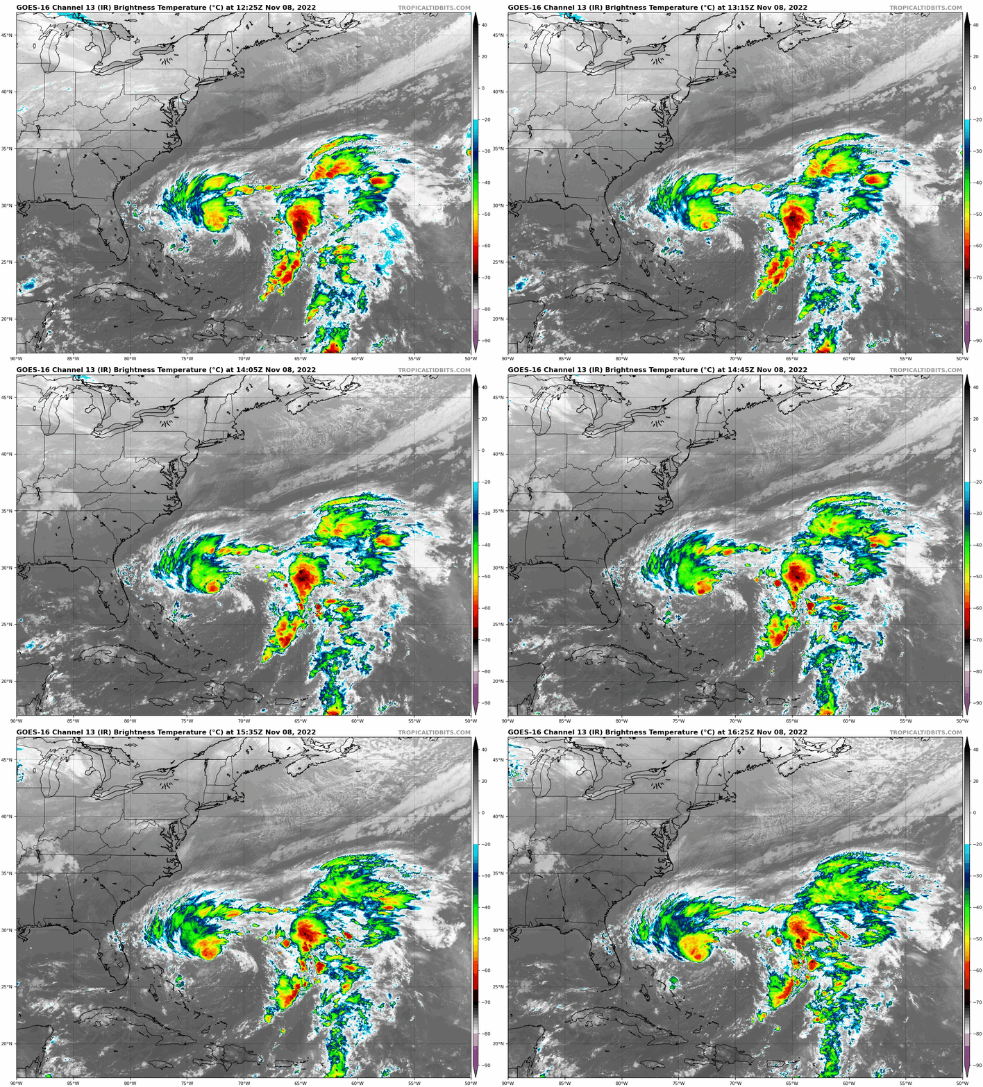
Satellite Loop
7:25 AM to 11:25 AM Tuesday, November 8
The circulation is better defined. We can also see the connection with the highest clouds tops (yellow and orange) wrapping around the west side and out to encompass the center. This is what will lead to further deepening of the Low and intensification.
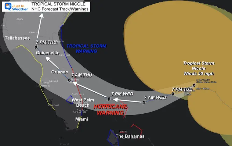
Forecast Track/Cone
A Hurricane Warning has been issued for The Bahamas and portions of the east coast of Florida. It should be a Category 1 storm with winds of 75 to 90 mph. A Storm Surge on the north end may cover a large area. Tropical Storm Warnings and Watches include southern and northern Florida, where winds will be lower but there is still some wiggle room where landfall might adjust.
A list of the Warnings and Watches are below.
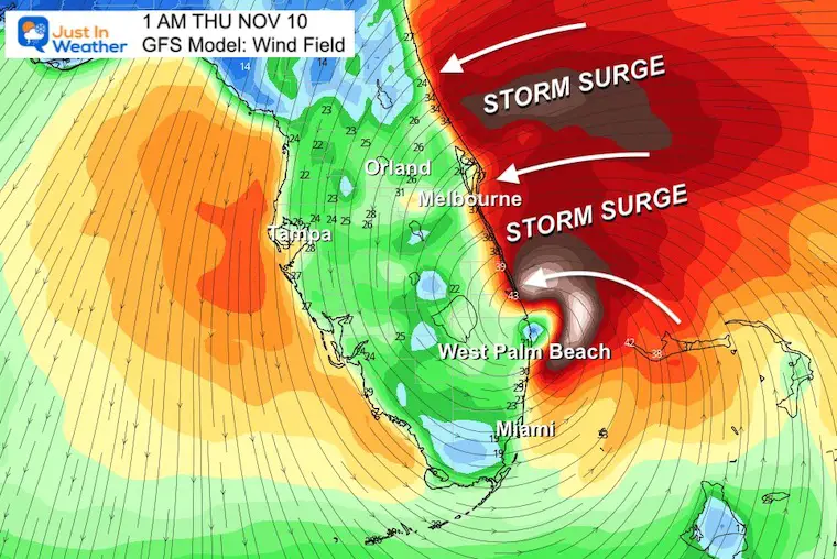
Wind Profile Forecast
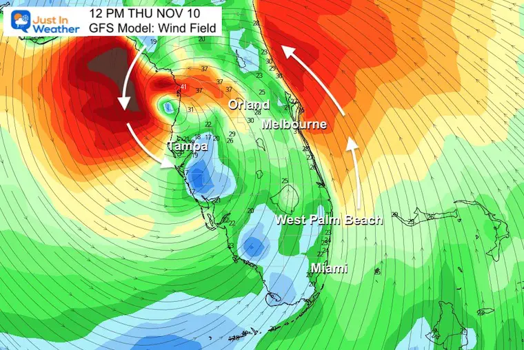
Given the wind field, strong onshore winds and water on the NORTH SIDE of the center at landfall will push in a Storm Surge as well.
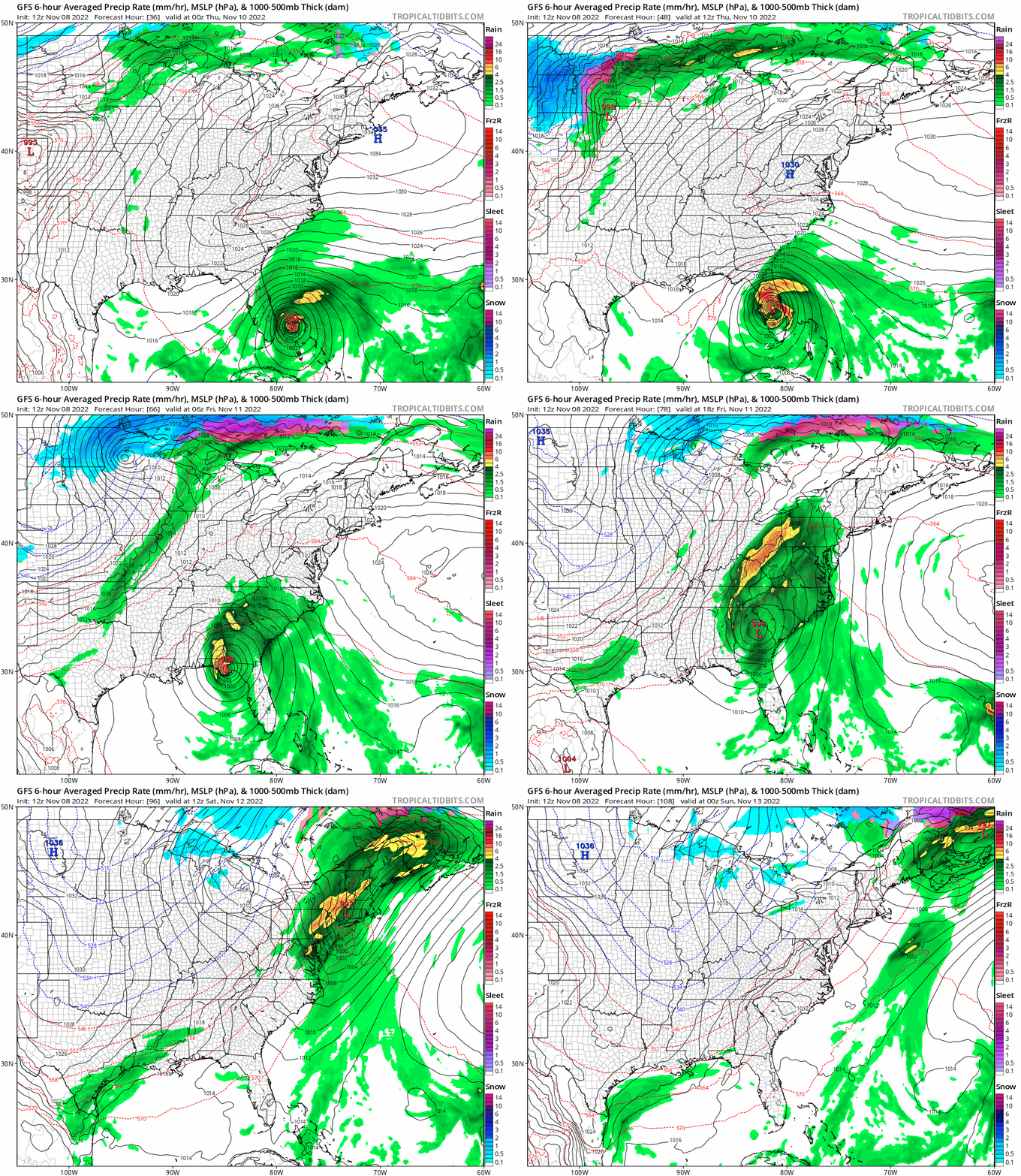
This is the GFS Model, which continues to swing this center into the Gulf before turning north, while the National Hurricane Center keeps it on land.
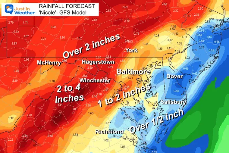
The track of the storm will curve north, but there is a discrepancy as to where that turn may take place. Either way, heavy rain will spread north into the Mid-Atlantic by Friday. So this will impact a large area.
Landfall Early Thursday Morning
The GFS shows this approaching landfall just after midnight on Thursday.
Tracking Inland
It looks like Orlando will have another close call… It was impacted by Hurricane Ian and the parks were shut down.
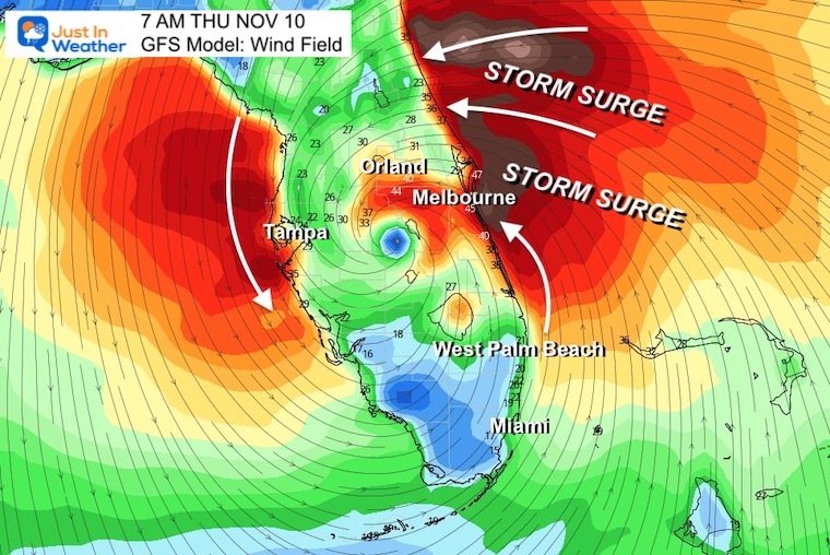
Will it reach The Gulf?
This GFS Model continues to show that it will, while the National Hurricane Center keeps the center on land when it turns north.
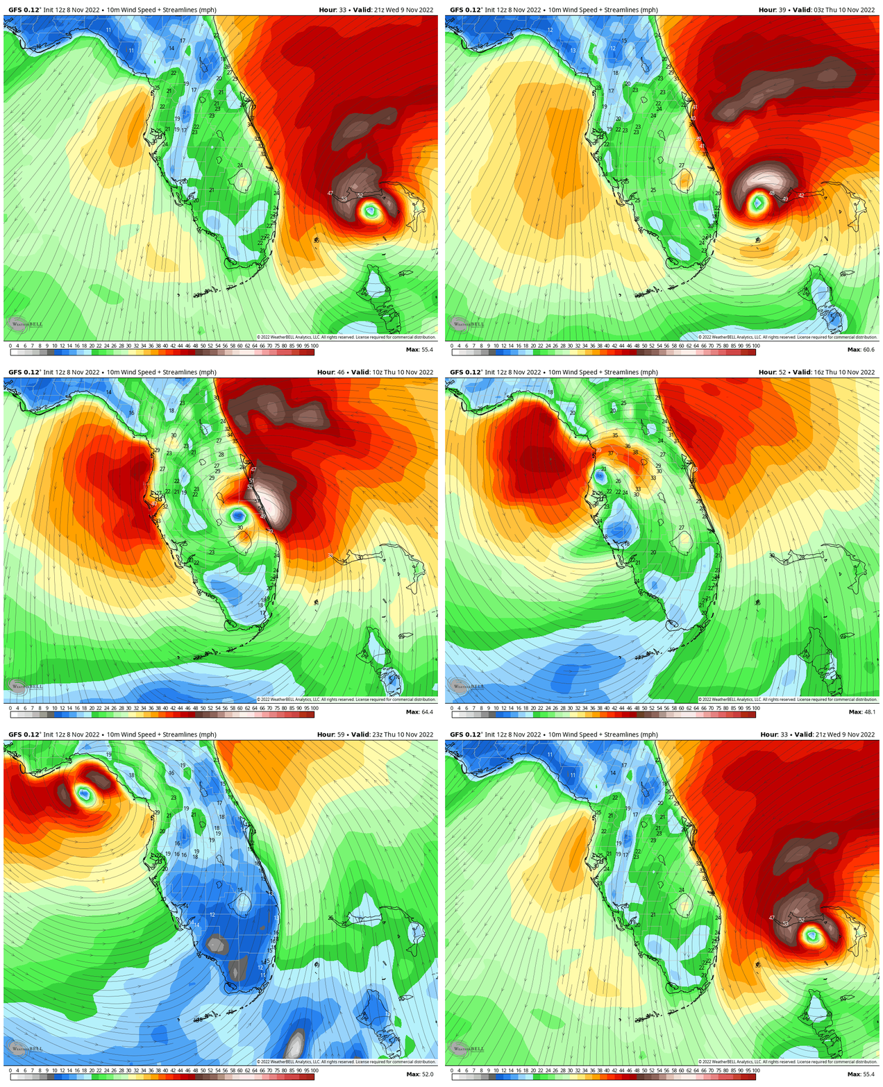
Forecast Animation: 4 PM Wed to 8 PM Thu
Wind Forecast (GFS)
SUMMARY OF WATCHES AND WARNINGS IN EFFECT:
A Hurricane Warning is in effect for…
- The Abacos, Berry Islands, Bimini, and Grand Bahama Island in the northwestern Bahamas
- Boca Raton to Flagler/Volusia County Line Florida
A Tropical Storm Warning is in effect for…
- Andros Island, New Providence, and Eleuthera in the northwestern Bahamas
- Hallandale Beach, Florida to Boca Raton, Florida
- Flagler/Volusia County Line Florida to Altamaha Sound, Georgia
- Lake Okeechobee
A Storm Surge Warning is in effect for…
- North Palm Beach, Florida to Altamaha Sound, Georgia
- Mouth of the St. Johns River to Georgetown, Florida
A Hurricane Watch is in effect for…
- Hallandale Beach to Boca Raton, Florida
- Lake Okeechobee
- Flagler/Volusia County Line to Ponte Vedra Beach, Florida
A Storm Surge Watch is in effect for…
- South of North Palm Beach to Hallandale Beach, Florida
- Altamaha Sound, Georgia to Savannah River, Georgia
- Anclote River, Florida to Suwannee River, Florida
A Tropical Storm Watch is in effect for…
- South of Hallandale Beach to north of Ocean Reef, Florida
- North of Bonita Beach to the Ochlockonee River, Florida
Model Forecast (GFS)
7 PM Wed to 7 PM Sat
(From Tropical Tidbits)
This shows the storm taking a WIDE TURN by crossing into the Gulf of Mexico and then north up to the Mid-Atlantic coast, exiting North Carolina on Saturday.
I still expect there will be some adjustments…
Rain Forecasts
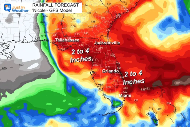
The interesting feature is that nearly the same amount of rain is forecast for Florida as the Mid-Atlantic, ranging over 2 inches.
Florida Forecast Rain (GFS)
Mid-Atlantic GFS Model
This is mainly Friday morning to Saturday morning when the storm moves away rapidly.
I will focus on our Mid-Atlantic forecast and model comparisons in my next report.
NEW: November Outlook Map From NOAA Showed This For The First Time
Also See: Winter Outlook Series:
Rainbow Ice Cave In Mt. Rainier A Very Rare Find: Photos And Video
ALSO, SEE THESE OTHER WINTER OUTLOOK REPORTS
Farmer’s Almanac Comparison
Rainbow Ice Cave In Mt. Rainier A Very Rare Find: Photos And Video
Triple Dip La Niña Winter
CONNECTION TO WINTER?
If you want a snowy winter, this is what you might want to look for in the rest of the tropical season. (You might be seeing a lot of commercial snow removal people out this Winter).
Rainbow Ice Cave In Mt. Rainier A Very Rare Find: Photos And Video
Wooly Bear Caterpillars
https://justinweather.com/2022/10/25/winter-weather-outlook-from-the-wooly-bear-caterpillar/
Persimmon Seeds
Click to see Top 20 and MORE
Winter Weather Folklore Top 20 And More Outlook Signals From Nature For Cold And Snow
Normals And Records: Maryland and Baltimore Climate History
Faith in the Flakes Gear
SNOWSTIX – Available Now
Please share your thoughts, best weather pics/videos, or just keep in touch via social media
-
Facebook: Justin Berk, Meteorologist
-
Twitter: @JustinWeather
-
Instagram: justinweather


