


January 4 Weather One More Cold Day Then January Thaw By Mid Week
Sunday, January 4, 2026 Overnight, there were some snow showers that crossed the region. I would not be surprised if there are reports of a fresh dusting of snow on…
June 7 2024
The National Weather Service (NWS) continues to investigate the severe weather that led to a tornado outbreak on Wednesday in the Mid-Atlantic. What has been confirmed so far is in this report below. Please note that this is not complete, and more information will be added to the final report today.
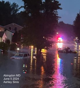
June 5, 2024, there were 23 reports of tornadoes across the US on Wednesday, according to NOAA’s Storm Prediction Center. Broken down locally:
This is the initial map. The conformed touchdowns (so far) are below.
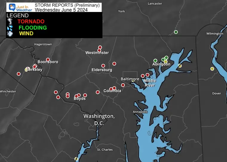
Some are duplicates for the same storm, while others may not verify. That is why NWS sends out teams to survey on site to investigate the damage and determine if there was a touchdown, the intensity, and the specific track. On Thursday they sent out 4 teams across 9 counties between Maryland, Virginia, and West Virginia.
As of Thursday night, there have been 7 confirmed tornadoes, but more surveys will be conducted today. The available reports are below. These include:
For Comparison, Here Are Other Notable Maryland Tornado Outbreaks:
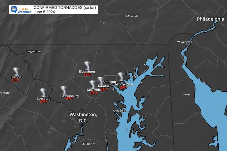
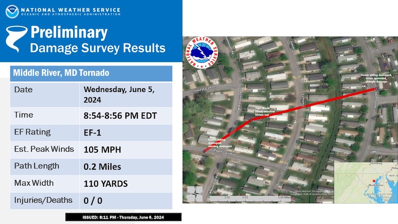
Here are the track maps and full survey reports for the 7 confirmed tornado touchdowns so far…
…NWS Damage Survey for 06/05/24 Tornado Event…
Overview…On the afternoon and evening of Wednesday June 5th, a warm front slowly lifted northeast across the eastern Panhandle of West Virginia into northern Virginia as well as central and northeastern Maryland. At the same time, low pressure tracked along the warm front causing severe thunderstorms and tornadoes to develop. At this time, the National Weather Service is confirming seven tornadoes in this report. Information is still being collected which could result in additional confirmations in the days ahead.
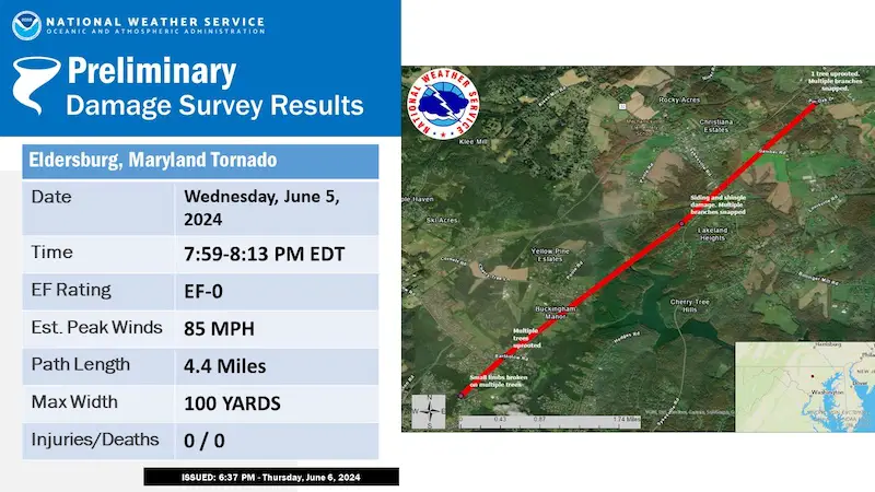
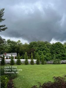
On the evening of Wednesday, June 5, 2024, an EF-0 tornado touched down 2 miles north-northwest of Eldersburg, Maryland. The National Weather Service conducted a damage survey and noted an initial area of tree damage near the intersection of Tanglewood Drive and Covington Court. A rotational damage signature was evident as tree damage was pointed in opposite directions.

The tornadic storm continued its track toward the northeast with additional damage observed along Bartholow Road near Sarah Drive. This included multiple large trees which were uprooted, one of which fell onto a house. Further damage was noted up the road just north of the intersection of Bartholow Road and Cherry Tree Lane. Dozens of trees had large sections and branches snapped off and topped. Observed tree damage was spread out into multiple directions.
Several minutes later, the tornado passed over Morgan Run before causing additional damage to the Lakeland Heights area. A home was seen with siding and shingle damage near Sun Berry Court and Lake Forest Court. Multiple large broken tree branches were noted behind the home. A few trees were damaged along Legacy Drive.
VIDEO
The damage signature to the northeast became more intermittent in nature as the tornado began to weaken. By 8:13 PM EDT, the final damage point was noted about 1 mile northeast of Gamber, MD.
Along Pin Oak Drive, a mid-sized tree was uprooted with multiple downed tree branches. Thereafter, the circulation dissipated while approaching MD State Route 140. No damage was noted along Route 140. A circulation evident on NWS Doppler weather radar corroborated this track as well.
The National Weather Service would like to thank the Carroll County Emergency Management Division for their assistance with this damage survey.
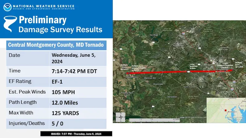
National Weather Service Baltimore/Washington Weather Forecast Office staff conducted a ground survey of storm damage that occurred in central Montgomery County MD on the evening of Wednesday, June 5, 2024.
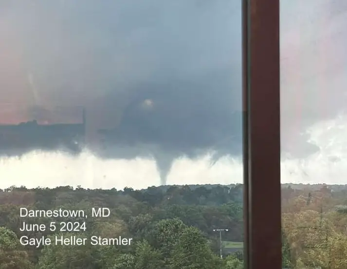
A mini-supercell thunderstorm formed southeast of the first tornado that impacted Leesburg, VA, west of Poolesville, MD.
Videos of funnel clouds near John Poole Middle School were provided by weather spotters. The first damage surveyed was at Tudor Farm along Whites Ferry Road (MD-107). About 2 dozen pine trees with trunk diameter exceeding two feet were snapped or uprooted at this location, laying in various directions. Media reported collapse of doors to a barn on the property.
From this location, the tornado lifted before dropping again in the vicinity of the 16000 block of Darnestown Road (MD-28). Here, about a dozen softwood trees were snapped and uprooted, falling in differing directions. These downed trees caused the closure of Darnestown Road for a period of time overnight. The tornado continued on the ground for about 0.5 miles, where additional damage was observed along and near White Ground Road. Here, many pine trees were snapped, with one pine tree debarked of about half of its bark on its remaining trunk.
The storm proceeded east across Seneca Creek State Park. Staff at the Washington Suburban Sanitary Commissions (WSSC) Seneca Water Resource Recovery Facility witnessed the tornado moving west-to-east directly adjacent to the south of their facility where power lines leading to the facility were snapped causing the facility to switch to backup power. After its trek south of the facility, it produced large broken branches that fell onto Great Seneca Highway (MD-119), partially blocking the roadway.
VIDEO
The storm continued east and entered the City of Gaithersburg. The first damage surveyed was along Desellum Avenue north of Gaithersburg High School. Here, pine trees were snapped, with large limbs downed. A pair softwood trees, approximately 30 yards apart, were snapped and fell directly towards each other, evidence of a tornado. The storm proceeded towards Old Town Gaithersburg, depositing a large limb on top of St. Martin of Tours Church at the intersection of South Summit Avenue and South Frederick Avenue (MD-355). The housing development directly east of the Gaithersburg City Hall was particularly hard-hit, with seven houses being condemned from trees and branches falling onto them.
One large oak tree with a trunk of about three feet was uprooted, and fell into a house on Dogwood Drive, where five occupants were injured and transported to the hospital. Several other trees were uprooted including one in the 200 block of Rolling Road, along with numerous large branches downed. One resident interviewed said they heard the Tornado Warning on their phone about three minutes before damage occurred near them. Once notified, their family took action to go to the basement of their home to remain safe.
This was the last area of concentrated damage in Montgomery County; it should be noted there may have been additional sporadic damage east of the City of Gaithersburg as the storm continued its eastern heading towards Columbia, MD, where it produced additional damage.
The National Weather Service Baltimore/Washington Weather Forecast Office acknowledges the assistance of the Montgomery County Office of Emergency Management and Homeland Security, Montgomery County Department of Health and Human Services, WSSC Water, and the City of Gaithersburg in helping conduct and provide information to this storm survey.
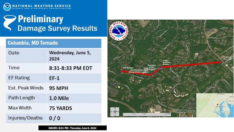
National Weather Service Baltimore/Washington Weather Forecast Office staff conducted a ground survey of storm damage that occurred in the Long Reach village of Columbia, MD, on the evening of Wednesday, June 5, 2024.
Damage was reported in Columbia, MD, in Long Reach village at Phelps Luck Drive, along High Tor Hill, and the 5600 block of Waterloo Road. First report of damage was at Phelps Luck Drive. A townhouse development near the intersection of High Tor Hill and Tamar Drive experienced concentrated tornadic damage. Here, approximately two dozen trees were snapped or uprooted, falling in various directions. About a dozen cars parked in the townhouse community parking lot were damaged by trees or large limbs falling onto them. Roofing fascia was peeled off of one townhome. Damage was more intermittent but present heading north toward the 5600 block of High Tor Hill.
Finally, tree damage was also reported at the 5600 block of Waterloo Road.
The National Weather Service Baltimore/Washington Weather Forecast Office acknowledges the assistance of the Howard County Office of Emergency Management in helping conduct and provide information contained within this storm.
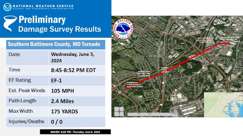
National Weather Service Baltimore/Washington Forecast Office staff conducted a survey of storm damage that occurred in southern Baltimore County on Wednesday, June 05, 2024.
NWS Doppler Weather Radar in Sterling, Virginia showed a rotating thunderstorm that developed a tornado based on this survey. Weather spotters and residents reported a tornado touchdown in the vicinity of the I-95 and I-195 interchange around 8:45 PM EDT.
This was confirmed with ground reports of several large tree trunks twisted and snapped in the vicinity of Riverchase Apartments along Selford Road and Deer Run Court. The tornado continued east northeast along a narrow path toward Friendship Road and Francis Ave. Multiple trees and wires were down along this route in a confluent pattern. The most notable was a large oak tree snapped midway up the trunk. The tree ended up laying in the north-northeast direction onto two cars and a house nearby.
An additional large oak tree and its root ball were laying 500 feet nearby closing off Friendship Road. Beyond this point, the tornado continued east northeast between Francis Avenue and Ingate Terrace. Additional large trees were sheared off along with large root balls toppled. Numerous power and phone lines were down as well with BGE and Verizon crews assessing and repairing the damage. Similar damage was observed as the tornado moved east southeast toward Elm and Oakland Road.
Several large trees were snapped midway along Elm Road, Huntsmoor Road, Oakland Road, and Ashbourne Road. Wires were down as well with one power pole twisted at its base at the intersection of Oakland Road and Elm Rd.
Beyond this point the path widened a bit with two medium spruce trees down along Oregon Avenue and several large branches along Carville Avenue. The tornado proceeded to lift and cycle as it crossed US-1 at I-95 and Potomac Avenue around 7:48 PM. The storm continued 1.4 miles east northeast toward Halethorpe, MD where an additional touchdown was noted around 8:50 PM EDT. This was confirmed with several damage reports in the vicinity of the 3600 block of Commerce Drive and Washington Boulevard and Lansdowne Road. Multiple trees were snapped along a narrow path from the Home Depot over toward Alside Building Materials and Amazon HQ.
The most notable damage was along Robert A Young Way between Alside Products and Amazon HQ. Four heavy overhead doors were blown out of the distribution warehouse along with pieces of the awning and roofing material removed from the Alside building. Several trees were also sheared at the canopy top within this same area. Additional large trees were taken down behind the LA-Fitness and Store-it storage facility along Washington Boulevard.
The damage was a bit broader in this area and most likely the end point to where the tornado finally lifted. Radar indicated the circulation clearing this point around 8:52 PM EDT.
The National Weather Service Baltimore/Washington Forecast Office would like to thank the Baltimore County Office of Emergency Management for providing helpful information and assisting in the survey today.
National Weather Service Baltimore/Washington Forecast Office staff conducted a ground survey of storm damage that occurred in southeast Baltimore County on Wednesday, June 05, 2024.
NWS Doppler Weather Radar in Sterling, Virginia showed a rotating thunderstorm that developed a tornado based on the survey. The circulation developed just to the south of Essex, MD at 8:43 PM EDT before racing north and strengthening toward Martin State Airport around 8:57pm. This is where a notable debris signature started to show up on radar as the storm pushed north-northeast.
This signature was confirmed with ground reports of multiple mobile homes damaged in the Williams Estates area as the strongest winds pushed through. The damage path was fairly narrow and short lived. Most of the damage included the removal of underpinning from several single and double-wide mobile homes in the Williams Estates community. This included several mobile homes along Wagon Train Road and Roundup Road as well as Cowhide Circle. Carports, sheds, and even a trampoline were tossed around the neighborhood as well.
Several trees were also snapped and turned in several different directions along Roundup Road and Cowhide Circle. The most notable damage was between Dahlia Lane and Roundup Road. This is where the height of the circulation looks to take place right around 8:58 PM EDT. Within this area, there were two double-wide mobile homes with significant damage. One of the mobile homes had underpinning removed from two sides of the building with the windows completely blown out and a shed tossed 50 yards in the opposite direction from its foundation. The resident who owns this home had roughly 30 seconds of video showing the tornado as it passed through. He recalled a loud boom which was most likely the shed being tossed from the foundation to the other side of the residence. Pieces of the shed and other debris were impinged into the side of the mobile home as well. The neighboring double-wide mobile home was also missing a majority of its underpinning along with several shingles and shingle material off the roof of the structure. Strapping on both units appeared to be secured with no other distinct structural damage to be observed.
Beyond this point, the tornado continued toward Roundup Road and Cowhide Circle, where the path widened. Much of the same damage was noted, but to a lesser extent with underpinning and shingles removed from several mobile homes in the area. The tornado continued toward the back of Cowhide Circle, where it eventually lifted. No additional damage was found beyond this point, nor were any injuries reported.
The National Weather Service Baltimore/Washington Forecast Office would like to thank the Baltimore County Office of Homeland Security and Emergency Management for providing helpful information and assisting in the survey today.
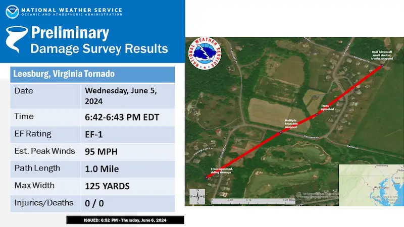
Staff from the National Weather Service Baltimore/Washington Weather Forecast Office conducted a ground survey of storm damage that occurred north of Leesburg on Wednesday, June 5, 2024.
NWS Doppler Weather Radar in Sterling, Virginia showed a rotating severe thunderstorm that developed a tornado. Radar also showed a tornado damage signature due to lofted debris from the tornado as it was occurring.
The tornado touched down southwest of Garriland Drive, north of Leesburg, in a wooded area where broken trees could be seen. The tornado proceeded North/northeast across Garriland Drive, south of the intersection of Garriland Drive and Turning Leaf Lane, where several trees were uprooted in different directions and minor vinyl damage and window damage could be seen. The tornado then crossed over Garriland Drive again into a field where tree damage could be seen in the distance. Garriland Drive turns north at this point where the tornado crossed it at London Council Lane. Near London Council Lane, a small tree was uprooted and small branches had been snapped off. The tornado continued northeast towards Springrun Lane where a small shelter had the plastic roof ripped off. Across Springrun Lane, tree damage could be seen going into the woods, but was not found any further beyond this point.
The National Weather Service would like to thank the citizens of Leesburg for their help and support in conducting this survey, and providing storm damage reports to the National Weather Service.
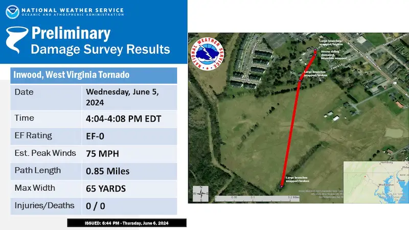
Staff from the National Weather Service Baltimore/Washington Weather Forecast Office conducted a ground survey of storm damage in Inwood WV that occurred on Wednesday afternoon, June 5, 2024. NWS Doppler Radar in Sterling, Virginia showed a rotating severe thunderstorm that developed a tornado. The tornado touched down south/southeast of Inwood in a field where tall grass could be seen disturbed in a rotating pattern. The tornado proceeded to move north across a cow pasture where a line of trees contained tree damage with large branches broken off.
The tornado then tracked north across the field, where additional tree damage and shingle damage occurred along Emery Lane. The tornado continued north towards Lucy Drive where gutter damage and additional tree damage occurred. The tornado then crossed Lucy Drive, where large tree branches were broken off. It is believed that the tornado lifted before reaching Middleway Pike as no further damage was observed past that point.
The National Weather Service would like to thank the citizens of Inwood for their help and support in conducting this survey, and providing storm damage reports to the National Weather Service.
I am aware there are some spelling and grammar typos and occasional other glitches. I take responsibility for my mistakes and even the computer glitches I may miss. I have made a few public statements over the years, but if you are new here, you may have missed it: I have dyslexia and found out during my second year at Cornell University. It didn’t stop me from getting my meteorology degree and being the first to get the AMS CBM in the Baltimore/Washington region.
One of my professors told me that I had made it that far without knowing and to not let it be a crutch going forward. That was Mark Wysocki, and he was absolutely correct! I do miss my mistakes in my own proofreading. The autocorrect spell check on my computer sometimes does an injustice to make it worse. I also can make mistakes in forecasting. No one is perfect at predicting the future. All of the maps and information are accurate. The ‘wordy’ stuff can get sticky.
There has been no editor who can check my work while writing and to have it ready to send out in a newsworthy timeline. Barbara Werner is a member of the web team that helps me maintain this site. She has taken it upon herself to edit typos when she is available. That could be AFTER you read this. I accept this and perhaps proves what you read is really from me… It’s part of my charm. #FITF