Thursday, June 6 2024
A true outbreak of tornadoes erupted across central Maryland on Wednesday afternoon and evening. This is the largest eruption of tornadoes in a single day in Maryland since 9 twisters were reported on June 1, 2012. A warm front was moving through the region, and the severe storm risk was minimal at Level 1 of 5, but the conditions proved otherwise.
According to The NOAA Storm Prediction Center, there were 23 reports of tornadoes across the US on Wednesday, June 5. Broken down locally:
- Maryland = 16 reports
- West Virginia = 4 reports
- Virginia = 1 report
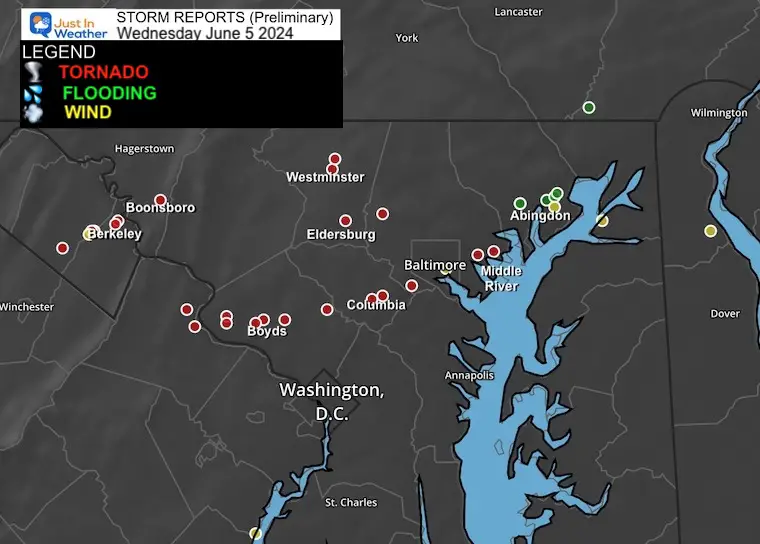
Local Maryland Map
In addition to the tracks of these tornadoes, extensive flooding occurred in Harford County, requiring water rescues.
A list of the Tornado Reports is at the bottom of this post.
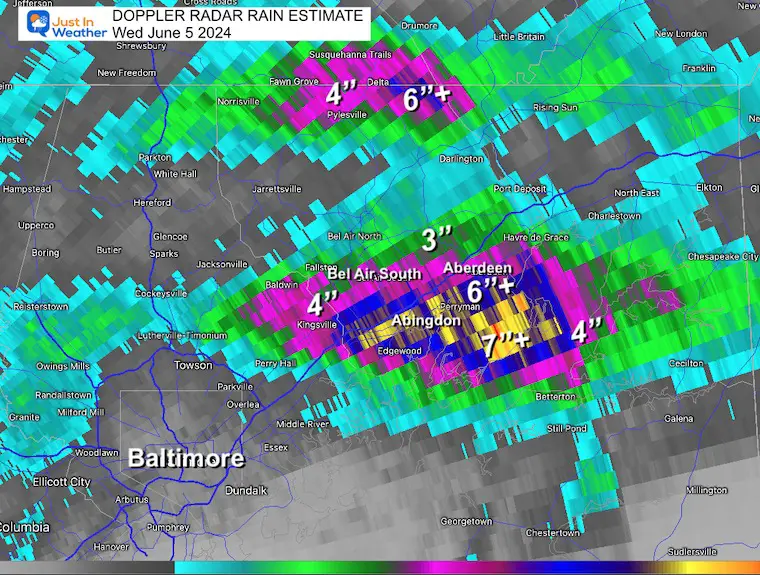
Rainfall: Doppler Radar ESTIMATE
Between 4 and 7 inches fell over Harford County, MD. This peaked long Route 7 Philadelphia Rd and the Bay near Abingdon and Aberdeen. This is a very low-lying area next to the Chesapeake Bay with hindered drainage, making the flooding worse. See FLOOD RESCUE VIDEO and photos below.
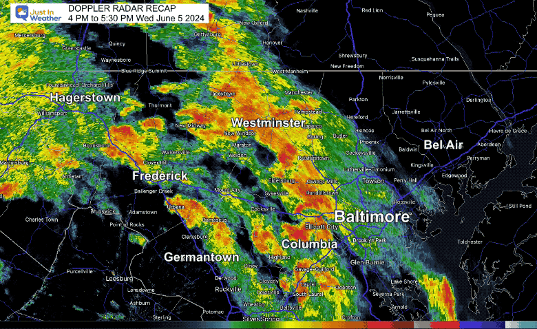
Local Radar Recap: 4 PM to 5:30 PM June 5, 2024
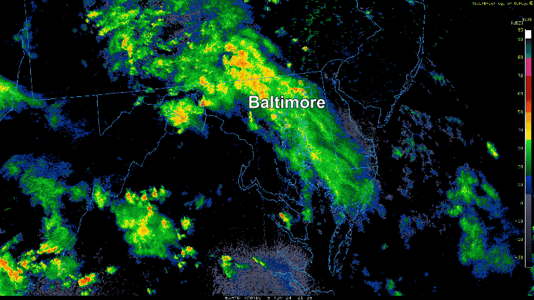
Radar Recap: 5:30 PM to 11 PM June 5, 2024
Tornado Confirmation
There have been numerous photos, videos, and reports. Today and perhaps over the next few days, the National Weather Service will conduct on-site surveys to confirm the touchdowns and impact intensity.
There has been extensive damage and some injuries. I want to wait until there is full confirmation to report, but you can see the notes in the report chart below.
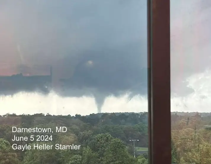
Darnestown, MD
Boyds Maryland Video
From Kaleb Shipley of All You Need Band
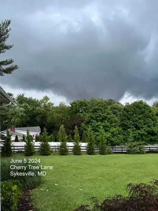
Sykesville, MD (Carroll County)
Photo from Cherry Tree Lane
Video: From Jackie Diachenko
Near Linton and Tanglewood Dr.
Note: She is a nurse and firefighter, so while stunned, she kept safety in mind.
Flooding in Harford County
Note: According to EMT Katrina Neeper, there at least 5 swift water rescues between Box Hill and Route 7.
Video from Neeper News
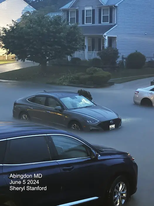
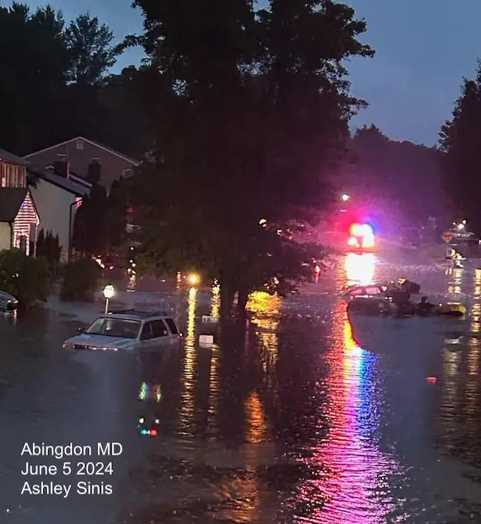
Abingdon Photos
From my friend Sheryl Stanford. I have been to this neighborhood, which is right next to the Chesapeake Bay.
From Ashley Sinis
NOAA Storm Reports
Reminder that these are preliminary from Storm Spotters. There will be multiple site surveys conducted to confirm touchdown, track, and intensity.
| TIME |
|
LOCATION |
COUNTY |
STATE |
NOTES |
| 2004 |
|
1 E Inwood |
Berkeley |
WV |
Numerous trees down along Emery Lane in Inwood. (LWX) |
| 2027 |
|
2 WNW Kearneysville |
Berkeley |
WV |
Video sent of tornado on the ground … likely near Route 9 and Short Road near the Berkeley/Jefferson County line. (LWX) |
| 2057 |
|
1 WSW Shepherdstown |
Jefferson |
WV |
Tornadic signature on radar from circulation crossing Kearneysville Pike & Shveda Way. Multiple trees down with road closed. (LWX) |
| 2058 |
|
1 WSW Shepherdstown |
Jefferson |
WV |
Tornadic signature on radar from circulation crossing Potomac Farms Drive & Comegy Drive. Multiple trees down with road closed. (LWX) |
| 2142 |
|
1 SSW Boonsboro |
Washington |
MD |
Trained spotter video shows a tornado over an open field between 5:42 and 5:45 PM just south of Boonsboro. (LWX) |
| 2242 |
|
3 ESE Waterford |
Loudoun |
VA |
Trees down near Garriland Dr and Frostleaf Ln coincident with tornadic debris signature. (LWX) |
| 2311 |
|
1 S Poolesville |
Montgomery |
MD |
Local spotter confirmed tornado lofting debris into the air. (LWX) |
| 2315 |
|
Poolesville |
Montgomery |
MD |
Trained spotter located at the junction of Rt. 28 and Rt. 117 in Maryland reported a tornado on the ground about 3 miles west of their location. (LWX) |
| 2323 |
|
3 E Dawsonville |
Montgomery |
MD |
Multiple trees down along the 16000 block of Germantown Road (LWX) |
| 2329 |
|
2 SSW Germantown |
Montgomery |
MD |
Significant damage to the Seneca Water Resource Recovery Facility as a result of a tornado. (LWX) |
| 2339 |
|
2 E Gaithersburg |
Montgomery |
MD |
*** 5 Inj *** Tree into house on Dogwood Drive with multiple injuries reported. (LWX) |
| 2342 |
|
2 E Gaithersburg |
Montgomery |
MD |
Numerous reports of homes damaged … wires and trees down as well as collapsed structures in and around the city of Gaithersburg. (LWX) |
| 2342 |
|
2 N Westminster |
Carroll |
MD |
The public sent images of a brief tornado on the ground just east of the Carroll County Regional Airport. Time estimated from radar. (LWX) |
| 0 |
|
2 NNW Eldersburg |
Carroll |
MD |
Carroll County EM reported tornado damage in the Gamber area. Approximately 8 structures were damaged. Parts of Cherry Tree Lane and Bartholow Road remain closed due to do (LWX) |
| 7 |
|
2 E Brookeville |
Montgomery |
MD |
Drone video sent of tornado on the ground east of Brookesville … MD. (LWX) |
| 7 |
|
Westminster |
Carroll |
MD |
At least two trees on houses in the Gamber and Eldersburg areas. (LWX) |
| 26 |
|
Columbia |
Howard |
MD |
Several videos of tornado on the ground in Columbia. (LWX) |
| 26 |
|
2 ENE Columbia |
Howard |
MD |
Several videos of tornado on the ground in Columbia. Numerous trees and powerlines down near the intersection of Tamar Drive and High Tor Hill in Columbia. (LWX) |
| 45 |
|
1 WSW Arbutus |
Baltimore |
MD |
Spotter report and video of tornado crossing I-95 near I-195 in Arbutus. Numerous trees and power lines down in the area. (LWX) |
| 57 |
|
1 NE Baltimore Martin S |
Baltimore |
MD |
Tornadic circulation evident on multiple radars. Damage reported to homes on Cowhide Circle in this enhanced VROT signature (up to 25 kt). (LWX) |
| 119 |
|
2 W Middle River |
Baltimore |
MD |
Numerous homes damaged and trees down in the Middle River area. (LWX) |
Please share your thoughts and best weather pics/videos, or just keep in touch via social media
RESTATING MY MESSAGE ABOUT DYSLEXIA
I am aware there are some spelling and grammar typos and occasional other glitches. I take responsibility for my mistakes and even the computer glitches I may miss. I have made a few public statements over the years, but if you are new here, you may have missed it: I have dyslexia and found out during my second year at Cornell University. It didn’t stop me from getting my meteorology degree and being the first to get the AMS CBM in the Baltimore/Washington region.
One of my professors told me that I had made it that far without knowing and to not let it be a crutch going forward. That was Mark Wysocki, and he was absolutely correct! I do miss my mistakes in my own proofreading. The autocorrect spell check on my computer sometimes does an injustice to make it worse. I also can make mistakes in forecasting. No one is perfect at predicting the future. All of the maps and information are accurate. The ‘wordy’ stuff can get sticky.
There has been no editor who can check my work while writing and to have it ready to send out in a newsworthy timeline. Barbara Werner is a member of the web team that helps me maintain this site. She has taken it upon herself to edit typos when she is available. That could be AFTER you read this. I accept this and perhaps proves what you read is really from me… It’s part of my charm. #FITF


