May 1 Weather Gradual Cooling Trend Will Bring Rain Into The Weekend
Wednesday, May 1 Morning Report One of the marks of May Day is an ancient European holiday celebrating the start of summer. It feels like we have had our taste…
Friday, April 5
Morning Report
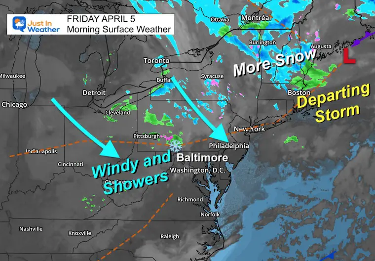
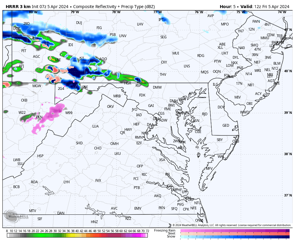
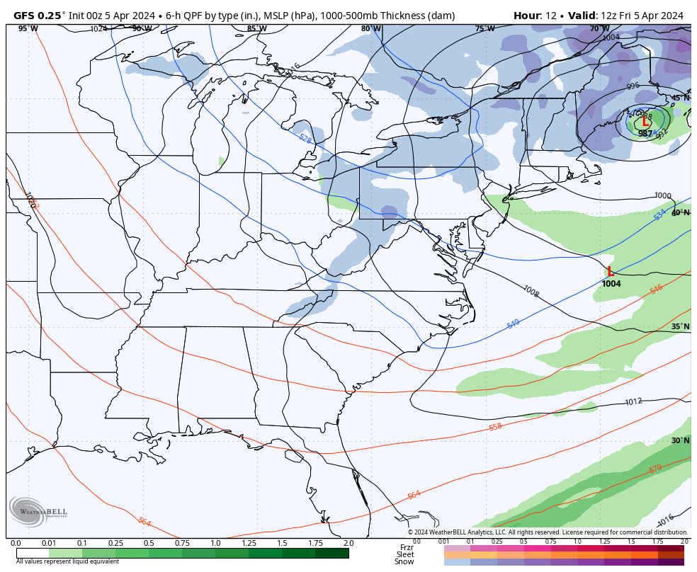
The storm is departing but we are still under the influence of cold air aloft. So, our region remains unsettled. The result will be gusty winds and developing clouds with showers. Like yesterday, some of these may contain thunder, small hail, or graupel.
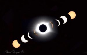
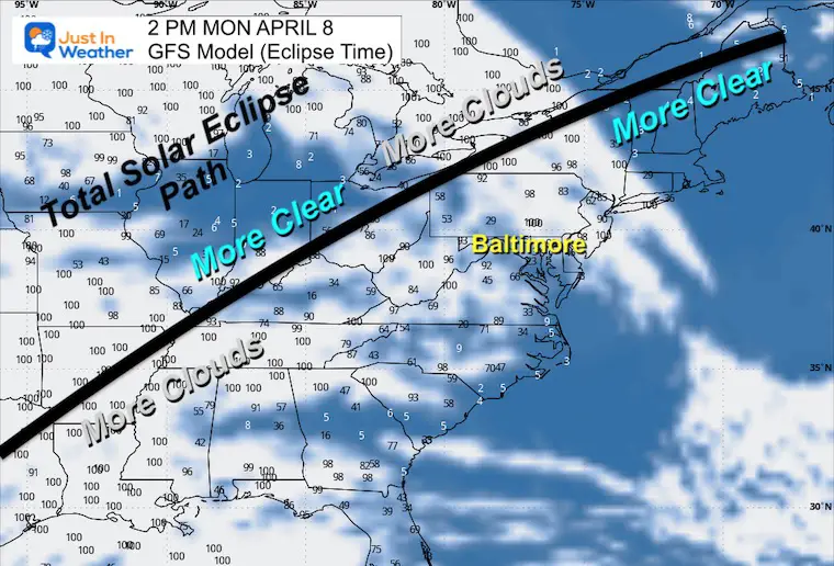
This weekend will slowly improve, and we expect more sun into Monday (locally) for the solar eclipse. I have a suggestion for the rest of the eclipse path as well.
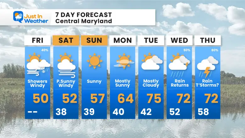
We can’t fully escape the rainy pattern. The next round will attempt to return by Wednesday into the end of next week. By then, however, it will be warmer.
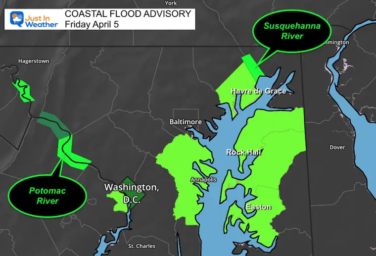
Flooding is still occurring with continued rainfall runoff. This includes:
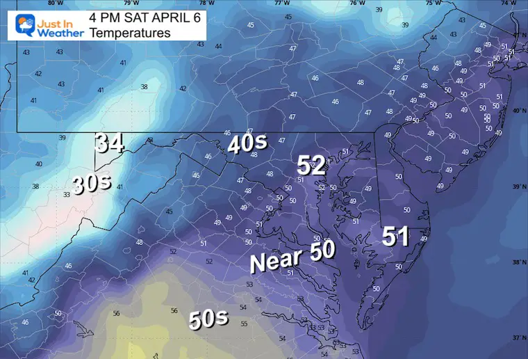
Snow continues to fall in New England around the old storm. As that slowly departs, we will still feel the cold winds for a few days. Our winds will increase during the day trying to produce more showers.
The snow showers in Western Maryland will continue as well.
This webcam is positioned at The Greene Turtle Deep Creek Lake and shows Wisp Resort, including a zoomed-in view of Squirrel Cage, The Face, the terrain park, Boulder, the mountain coaster, the tubing park and a shot of McHenry Cove at Deep Creek Lake!
More snow will fall over the high mountains, signaling colder air aloft, which is why we expect more self-destructing sunshine and showers to return.
Once again, some of these showers in metro areas may include thunder, small hail, or graupel.
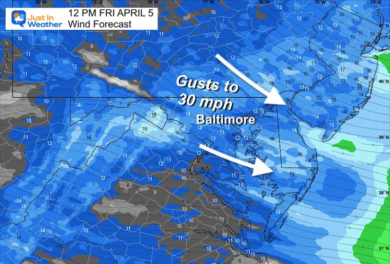
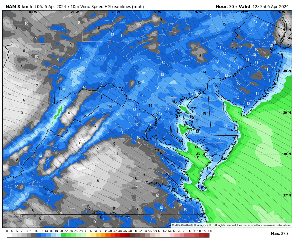
Another surge of wind will increase during the day and peak with some of those showers.
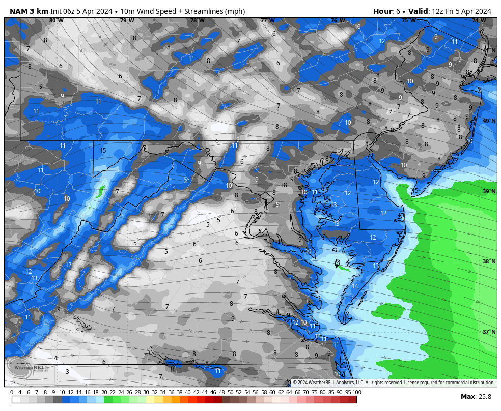
Most areas may see wind gusts to 30 mph. Like yesterday, some spots could push 40 mph.
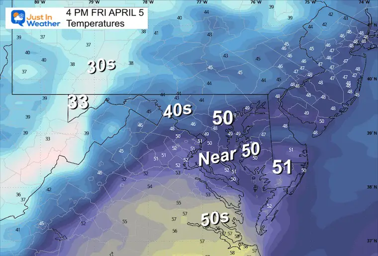
Well above freezing at the surface, but we can get that wintry stuff falling from much colder clouds.
2024 SOLAR ECLIPSE INFO: Compare to 2017 Event
Sunrise at 6:44 AM
Sunset at 7:35 PM
Normal Low in Baltimore: 40ºF
Record 25ºF in 1881
Normal High in Baltimore: 63ºF
Record 84ºF 2010
We can expect stronger winds as the stormy pattern departs. Gusts may reach up to 40 mph.
We break free of the rain for a few days. The solar eclipse snapshots are below.
We can expect the next rainy pattern to return by Wednesday and Thursday.
This is a SUGGESTION, NOT A PROMISE
An upper-level force will bring moisture up along the shadow path. At this time, it looks poor for Texas and the Deep South, a little more optimistic across the Mid West to New York and New England.
Rain in southern Texas with some spotty showers to the north.
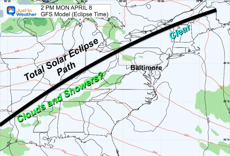
More clouds south, while the breaks are outlooks and not perfect.
The band of clouds across New York might be high thin cirrus clouds and could allow for a filtered view of the sun.
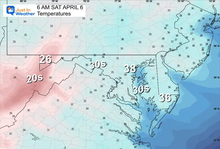
The weekend will be chilly, then warming next week.
As we break free of the rain, more sun is expected.
Eclipse Day (reminder only 88% coverage in Baltimore), should be mostly sunny, however high clouds could invade the sky.
Another rainy pattern is expected to return for the second half of next week.
Click to see more and ‘Book’ a visit to your school

I am aware there are some spelling and grammar typos and occasional other glitches. I take responsibility for my mistakes and even the computer glitches I may miss. I have made a few public statements over the years, but if you are new here, you may have missed it: I have dyslexia and found out during my second year at Cornell University. It didn’t stop me from getting my meteorology degree and being the first to get the AMS CBM in the Baltimore/Washington region.
One of my professors told me that I had made it that far without knowing and to not let it be a crutch going forward. That was Mark Wysocki, and he was absolutely correct! I do miss my mistakes in my own proofreading. The autocorrect spell check on my computer sometimes does an injustice to make it worse. I also can make mistakes in forecasting. No one is perfect at predicting the future. All of the maps and information are accurate. The ‘wordy’ stuff can get sticky.
There has been no editor who can check my work while writing and to have it ready to send out in a newsworthy timeline. Barbara Werner is a member of the web team that helps me maintain this site. She has taken it upon herself to edit typos when she is available. That could be AFTER you read this. I accept this and perhaps proves what you read is really from me… It’s part of my charm. #FITF
Click each map for the maps and snow spotter lists.
Click here for the maps and full report
Click here or the map to see: The Snow Report Ending Jan 16