April 20 Summer Heat And Timing The Storms Saturday Evening
April 20, 2023
Thursday Morning Update
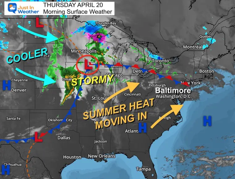
Another pattern repeat is underway. As the winds shift, we pump in summer heat for a few days. This will include reaching the 80s, but much cooler for places near the Chesapeake Bay or Ocean shorelines.
The main event will be the cold front on Saturday evening. Showers and thunderstorms may affect your plans, but also bring in some needed rain on average close to 1/2 inch. This will be followed by a much cooler pattern next week.
Morning Surface Weather
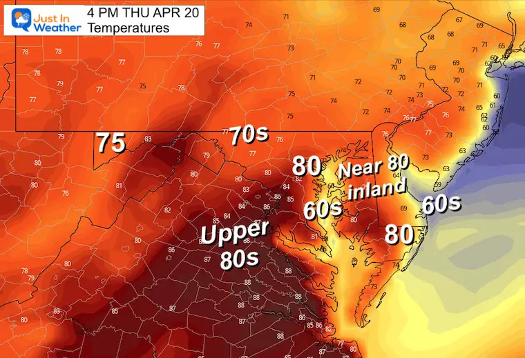
Afternoon Temperatures
Warming up to near 80ºF
HOWEVER THIS DEPENDS ON LOCATION
- It will be COOLER BY THE WATER
- WARMER FARTHER INLAND
Subscribe for eMail Alerts
Weather posts straight to your inbox
Sign up and be the first to know!
CLIMATE DATA
TODAY April 20
Normal Low in Baltimore: 45ºF
Record 27ºF in 1904
SNOW: Trace in 1983
Normal High in Baltimore: 68ºF
Record 94ºF in 1941
REPORTS:
Winter 2023 Recap: My BUSTED Snow Outlook
La Niña Has Ended. El Niño May Return By Fall
Friday Weather
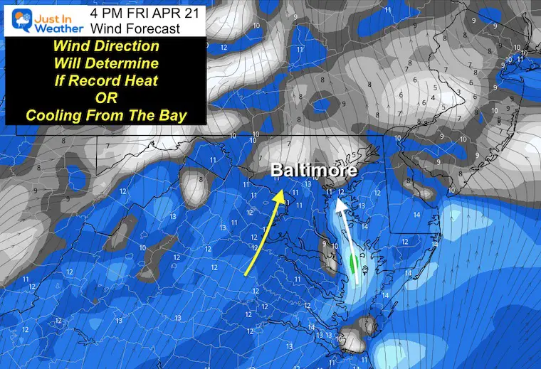
Wind Direction will make or break the chance for record heat!
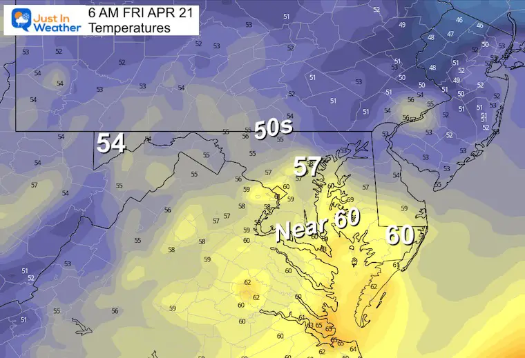
Morning Temperatures
A mild start…
Wind Forecast
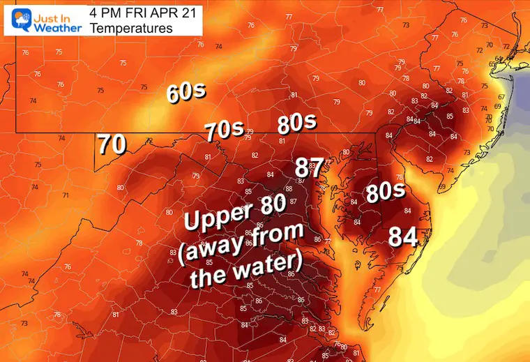
A breezy wind from the south will develop… However, any shift from the Southeast will bring a cooling influence from the Chesapeake Bay. As BWI Airport is within 10 miles of the water, this will truly determine if they reach the record or not.
Afternoon Temperatures
Record for Baltimore: 88ºF in 1957. It will be close and depends on the wind direction at BWI.
Weekend Weather
Friday Evening to Monday Morning
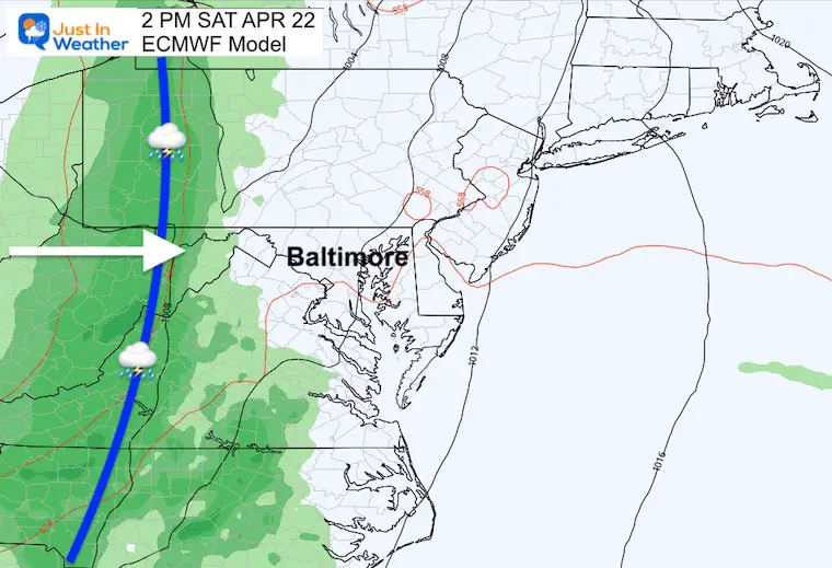
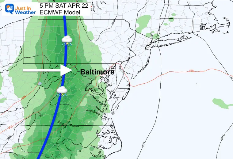
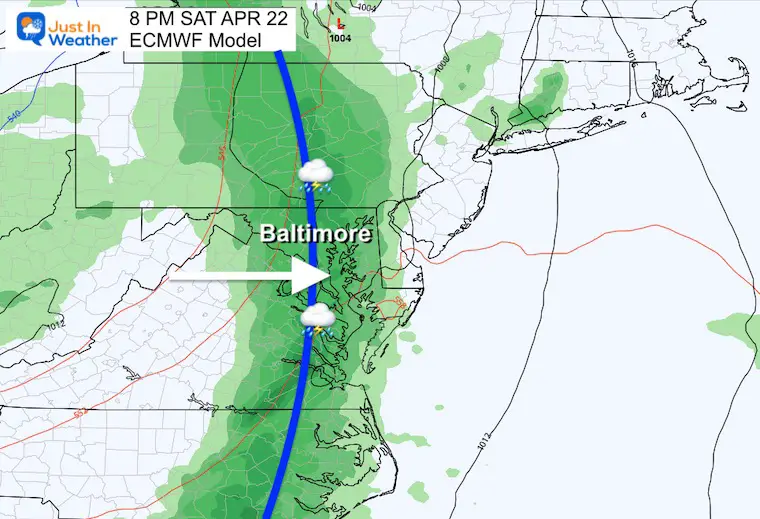
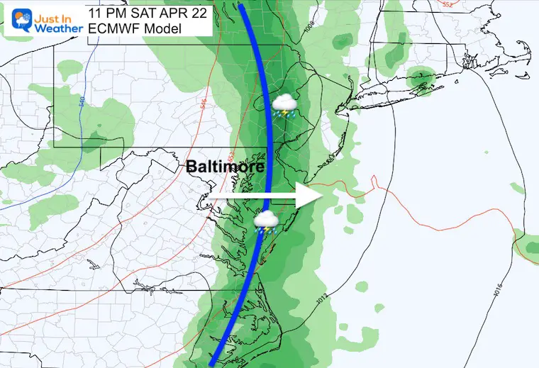
The storm line may appear to slow up in the Ohio Valley on Friday. It will get a push east on Saturday, arriving in metro areas later in the day. Then sweep through and be off the coast on Sunday, and get replaced by cooler winds.

Snapshot Saturday Evening
This is still NOT PERFECT. It is our first look to narrow down the time frame for the arrival of the rain and storms.
At this point: Western Maryland = Saturday afternoon.
Central and Eastern Shore Areas = Saturday AFTER 4 PM to Midnight
Please Note: The timing can often be misleading in these products. The snapshots are a 3-hour summary. Often we end up with the storms arriving an hour or two earlier than this product suggests.
2 PM
5 PM
K-Index
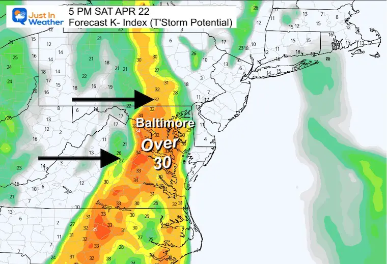
This is a factor of thunderstorm development and intensity. When the value is ABOVE 30, the chances increase for heavy thunderstorms and possibly severe cells developing.
For the math Geeks:
The K index is a measure of thunderstorm potential based on the vertical temperature lapse rate and the amount and vertical extent of low-level moisture in the atmosphere.
K = T(850 mb) + Td(850 mb) – T(500 mb) – DD(700 mb)
In degrees ºC, where T represents temperature, Td represents dewpoint temperature, and DD represents dewpoint depression at the indicated level.
8 PM
11 PM
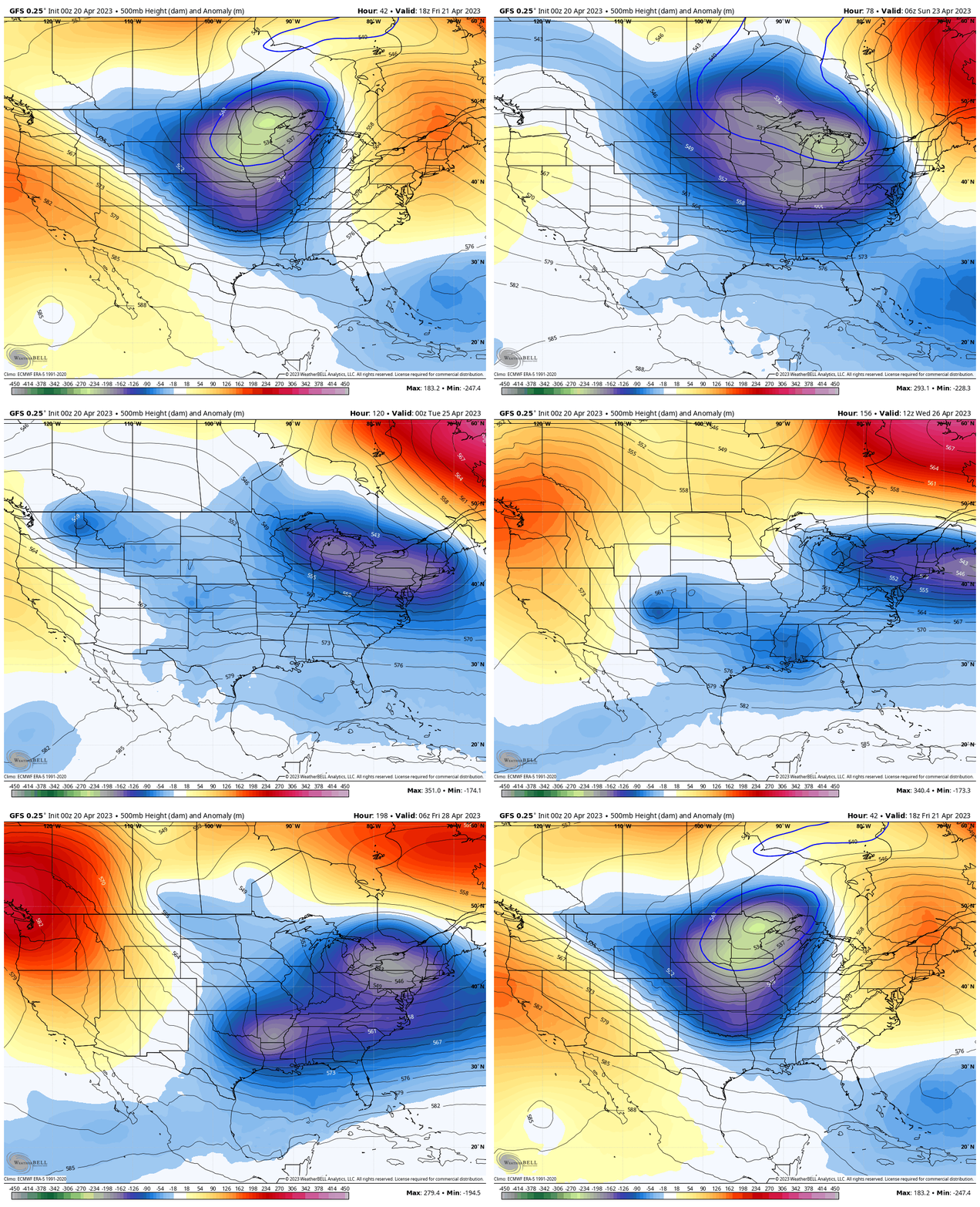
Jet Stream Forecast
Friday, April 21 to Friday, April 28
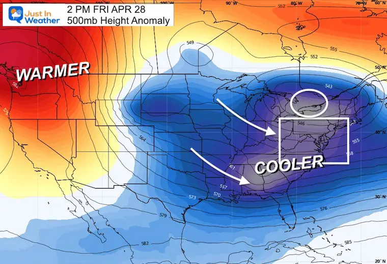
A flip in the upper air flow will keep us cooler than average next week.
Snapshot Friday April 28
7 Day Forecast
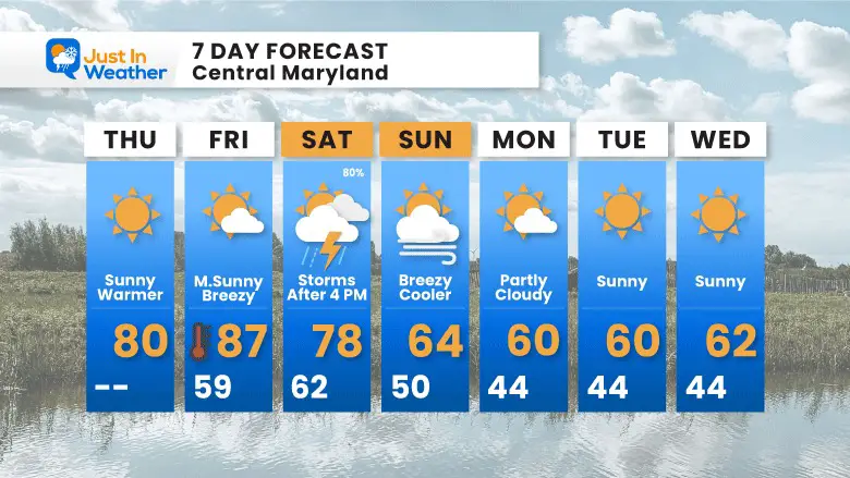
This weekend will be a transition. After the stormy Saturday evening, a shift in the jet stream will overcorrect back to below-average temperatures next week.
STEM Assemblies/In School Fields Trips Are Back
Click to see more and ‘Book’ a visit to your school
Please share your thoughts, best weather pics/videos, or just keep in touch via social media
-
Facebook: Justin Berk, Meteorologist
-
Twitter
-
Instagram
RESTATING MY MESSAGE ABOUT DYSLEXIA
I am aware there are some spelling and grammar typos, and occasional other glitches. I take responsibility for my mistakes, and even the computer glitches I may miss. I have made a few public statements over the years, but if you are new here you may have missed it: I have dyslexia, and found out during my second year at Cornell University. It didn’t stop me from getting my meteorology degree, and being first to get the AMS CBM in the Baltimore/Washington region. One of my professors told me that I had made it that far without knowing, and to not let it be a crutch going forward. That was Mark Wysocki and he was absolutely correct! I do miss my mistakes in my own proofreading. The autocorrect spell check on my computer sometimes does an injustice to make it worse. I also can make mistakes in forecasting. No one is perfect predicting the future. All of the maps and information are accurate. The ‘wordy’ stuff can get sticky. There has been no editor that can check my work when I needed it and have it ready to send out in a newsworthy timeline. Barbara Werner is a member of the web team that helps me maintain this site. She has taken it upon herself to edit typos, when she is able. That could be AFTER you read this. I accept this and perhaps proves what you read is really from me… It’s part of my charm.
#FITF


