February 27 Chilly Rain Starts Late And A Snowstorm For New York To Boston
February 27, 2023
Monday Morning
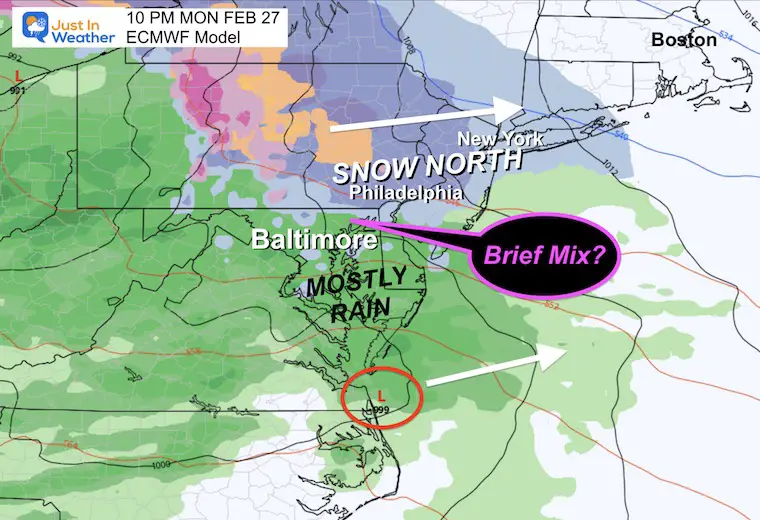
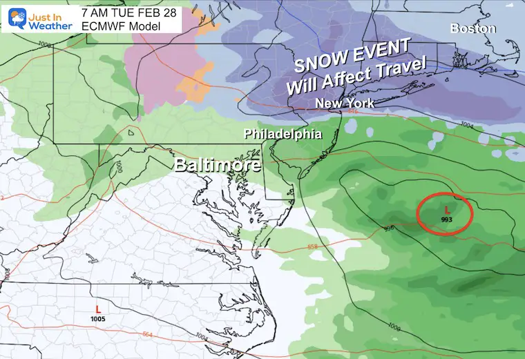
Each one of these recent storms has trended farther south and colder. We are still on the rain side in the Mid Atlantic, with the snow and wintry mix clipping the northern areas. The difference this time is how close the snow will fall, which could impact many travelers who may be heading to New York or New England. For the big Northeast Cities, this will be an impactful snowstorm that may have wider affects on train and plane travel.
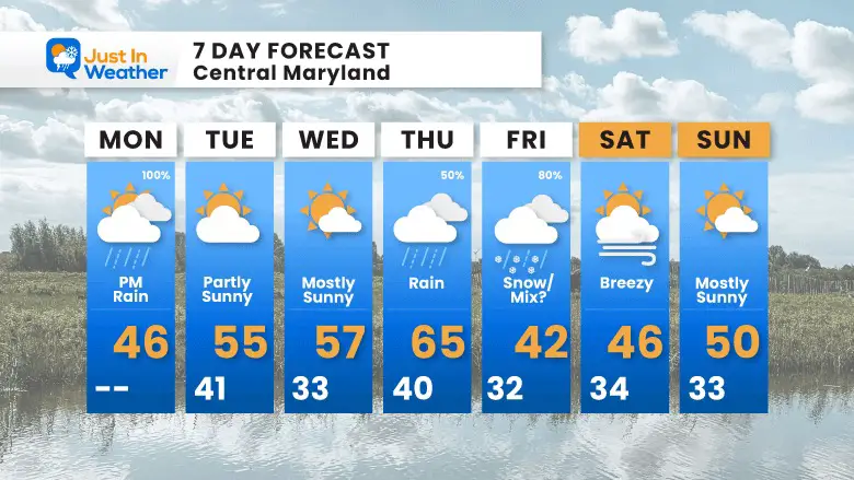
The middle of the week will be mild for us, with rain on Thursday. However, there has been consistent indication that Friday may bring snow or a wintry mix. I am as skeptical as anyone at this point and lacking trust in the modeling. But March has historically brought surprises and we must keep an open mind. I will show you below.
National Weather
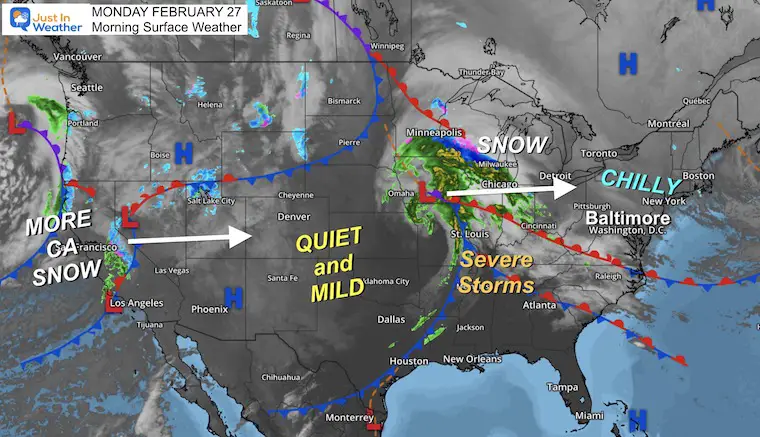
High Pressure has brought in a bubble of chilly air from the Northeast into our region. The next storm is entering the Great Lakes and will bump into this air mass. This will expand developing snow for Pennsylvania, New York, and New England.
We will get rain by afternoon, however some sleet could mix in by the Maryland/PA line this evening.
California continues to get a series of cold storms. These will march across the country and bring us more storms later this week.
Morning Temperatures
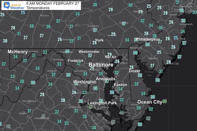
We have a seasonally chilly start with many areas near or below freezing. It is dry this morning, but when the clouds catch up we will keep temps chilly… Just warm enough for us to get rain in the afternoon.
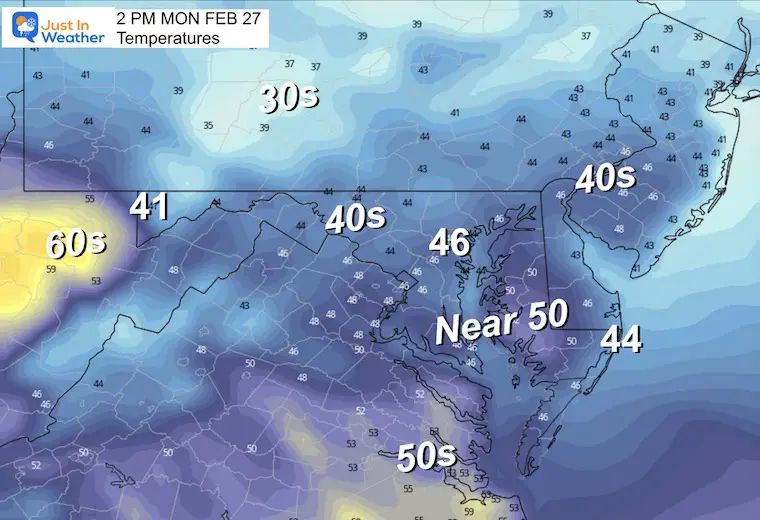
Afternoon Temperatures
It will be a much cooler day with the rain arriving.
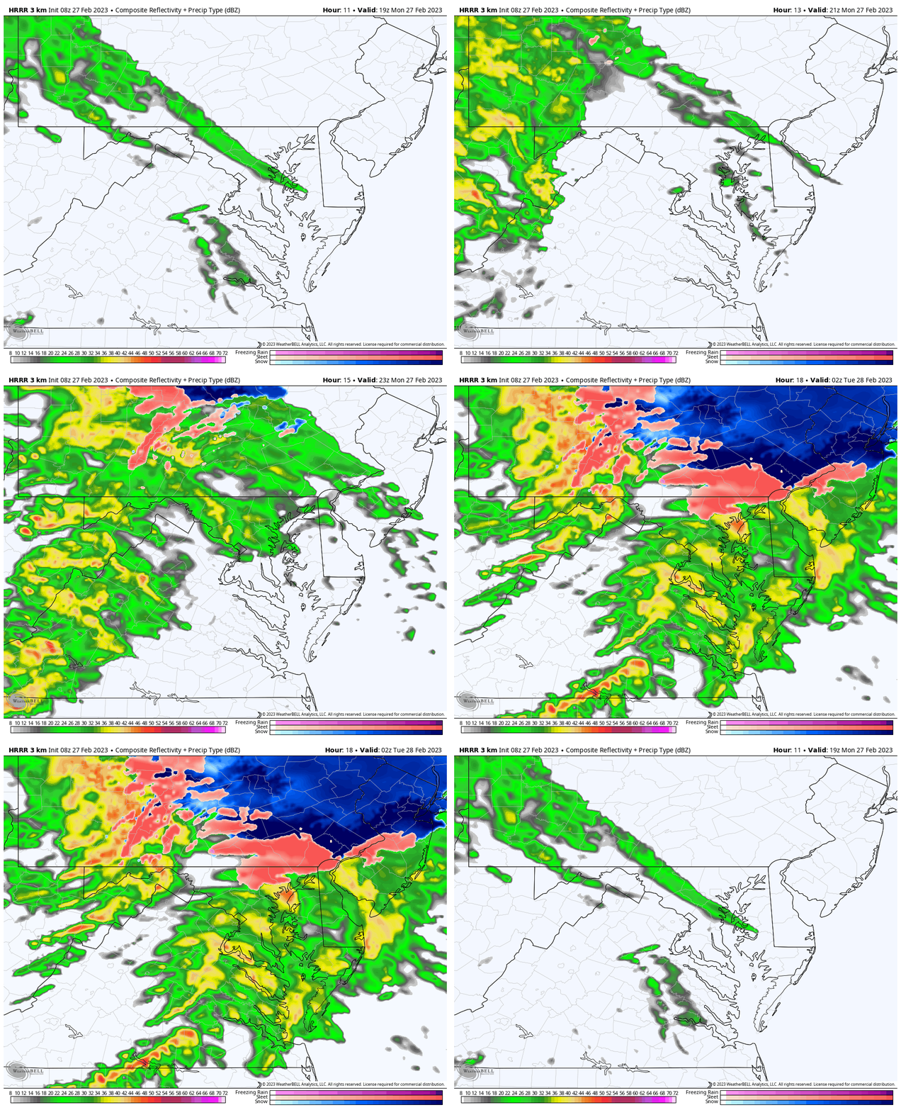
Radar Simulation
HRRR Model 2 PM to 9 PM
Rain showers will begin between Noon and 2 PM, then become more steady by evening.
Cold enough air may mix in sleet or slushy snow near the PA and MD line this evening.
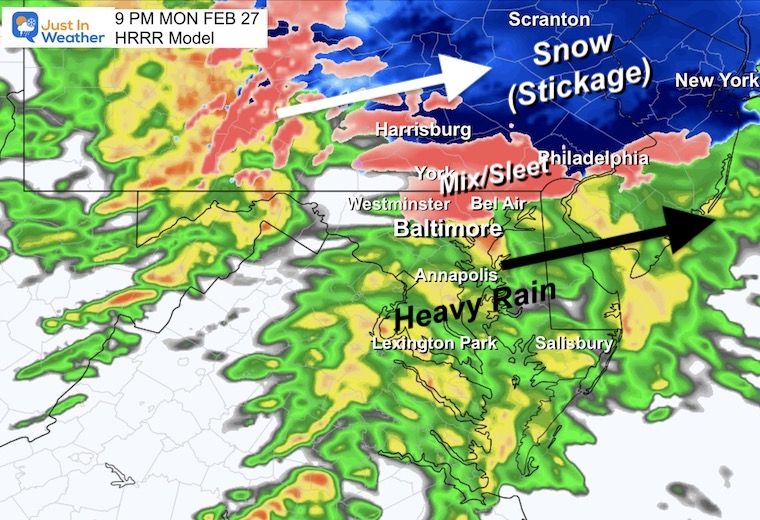
Snapshot at 9 PM
This will be mostly a rain event, however the colder air aloft may allow for sleet or wet snow to mix in across Northern Maryland and Southern PA. Temps should remain above freezing, so the road impact will be farther north.
Tonight
The European Model shows the mix for us, but this will be a winter storm farther north.
Subscribe for eMail Alerts
Weather posts straight to your inbox
Sign up and be the first to know!
CLIMATE DATA
TODAY February 27
Normal Low in Baltimore: 29ºF
Record 9ºF in 1934
SNOW: 3.5” in 1940
Normal High in Baltimore: 49ºF
Record 76ºF in 1997
Tuesday
That storm will be impacting New York and New England. If you have travel plans in that direction, they will surely be impacted. If you are flying, there may be some residual impact across the Northeast to consider.
Rain showers will be ending early in the Mid Atlantic.
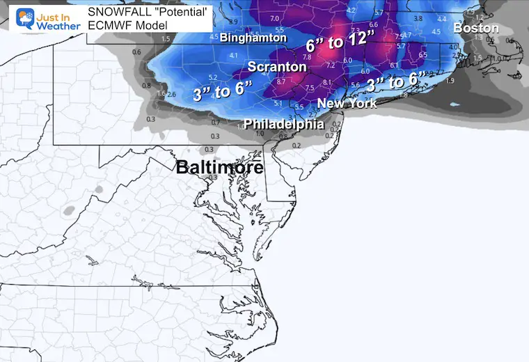
Snowfall Forecast
It’s been a while since I was able to show this product. I wanted to show the potential snowfall for the cities to our north that will last through Tuesday.
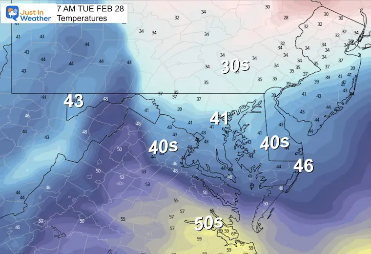
Local Temperatures
Morning
Rain showers may be left over early, but will be ending with some clearing in the afternoon.
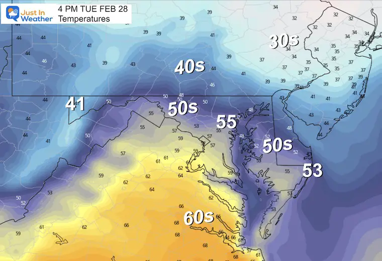
Afternoon
Milder with some sun breaking out after the storm moves away.
Next Notable Storm: Thursday to Friday
What we may see is another WARM RAIN on Thursday with temps in the 60s, followed by a second wave of Low Pressure forming in the colder air on Friday.
Friday
This storm will have colder air and a track that in a normal winter would almost guarantee snow. It is very logical to be skeptical, I am as well. This is the European Model solution which is much colder than the GFS which has the track farther north and just rain for us.
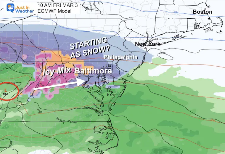
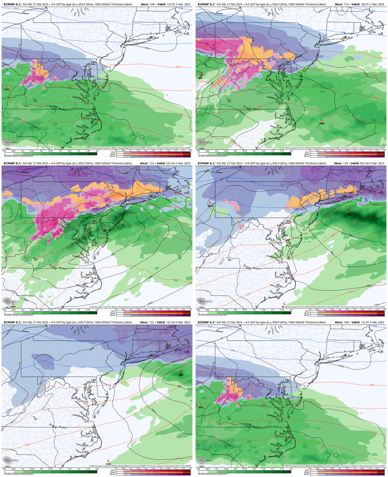
Storm Simulation: Friday 7 AM to Saturday 7 AM
Here we see snow Friday morning as it taps into air just cold enough, but eventually transitioning to a wintry mix and rain (south). I would not even venture a guess of how much, let alone stickage with marginal temperatures.
Note: The GFS Model is WARMER and I will show that comparison in my next report. I just wanted to show you this model since it is more reliable and this will be a talker this week.
7 Day Forecast
I know this looks familiar, but this week is our taste of those record storms that hit California. It is difficult to consider any snow at this point, but March has a history of bringing surprises, so it’s worth considering snow even being skeptical.
I will track this and bring up some history in my next few reports.
Also See:
Winter History: Low Snow And Late Starts
See my research based on Baltimore data since 1883.
Subscribe for eMail Alerts
Weather posts straight to your inbox
Sign up and be the first to know!
STEM Assemblies/In School Fields Trips Are Back
Click to see more and ‘Book’ a visit to your school 
My Winter Outlook: Not A Typical La Niña!
I see many factors to support colder influence with multiple systems. Early and later in winter. Check it out. https://justinweather.com/2022/11/22/winter-outlook-2023-for-snow-not-typical-la-nina-plus-polar-vortex-disruption/
Also See The Winter Outlook Series:
Farmer’s Almanac Comparison
September Starts Meteorological Autumn: Weather Climate Stats For Maryland at Baltimore
Triple Dip La Niña Winter
https://justinweather.com/2022/09/09/winter-outlook-2023-la-nina-triple-dip-expectations/
CONNECTION TO WINTER?
If you want a snowy winter, this is what you might want to look for in the rest of the tropical season. https://justinweather.com/2022/08/31/record-august-for-no-named-tropical-storms-closer-look-at-snow-following/
Woolly Bear Caterpillars
https://justinweather.com/2022/10/25/winter-weather-outlook-from-the-wooly-bear-caterpillar/
Persimmon Seeds
Click to see Top 20 and MORE
Normals And Records: Maryland and Baltimore Climate History
Please share your thoughts, best weather pics/videos, or just keep in touch via social media
-
-
Facebook: Justin Berk, Meteorologist
-
Twitter: @JustinWeather
-
Instagram: justinweather
-


