Colder Air On The Way And The Snow Risk Still Lingers Wednesday
January 29, 2023
Sunday Night Update
As we approach the week ahead, there is building frustration and pessimism for winter lovers. Today marks 365 days since Baltimore last had 1 inch of snow at BWI. There was 1 inch on Jan. 28 and 1/2 inch on Jan. 29 in 2022. Any other substantial for the rest of last season and this season was limited to the colder suburbs after that, although there was a minimal event on March 12 of under 1 inch at the airport.
I still am conflicted with two parts of my forecast, and for that matter some others as well. I have high confidence it will get colder. There is a large pool of arctic air across the central US that is diving south into Texas. That will eventually reach us in the east.
The other part is one I have discussed for a few days and is still questionable: Will we get snow?
There is a very simple explanation as to why this is not a solid yes or no, but the reason will keep us threading the needle a little longer. In short, you may not see snow on your weather app or local forecast, but there are some computer models still trying to keep us in play early Wednesday.
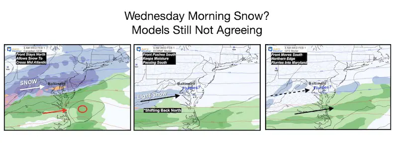
Computer Model Madness
Please give me a couple of minutes to explain these maps. In fact there are two others that are also still showing snow. I hope this will help you understand why a few of us forecasters are still keeping our snow chances around and you will see it is not hopeful wish casting.
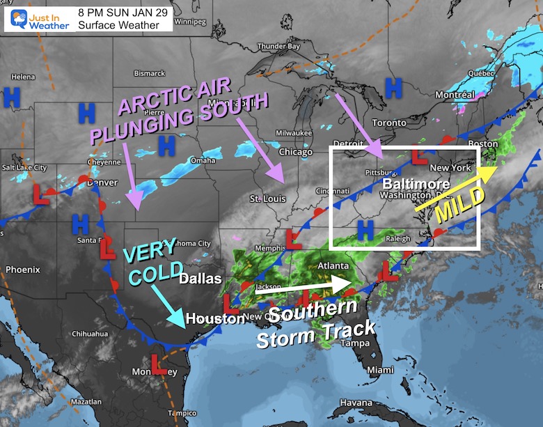
Sunday Evening Surface Weather
A cold front is draped along the Ohio Valley and will be slow moving. There is a true arctic air mass on the other side, and it has made a serious deep dive into Texas. Check out the temperatures below.
We remain on the mild side for another day, then the challenge will begin for us. When will the front arrive and how far can it reach? This will determine both how cold we get AND where the next impulses of weather (snow and rain) will ride.
It is ALL ABOUT THE LOCATION OF THAT FRONT!
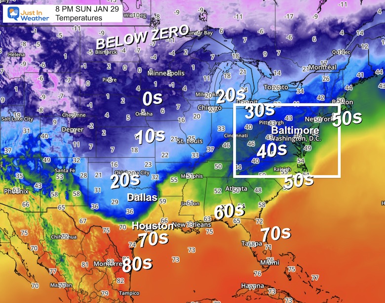
Sunday Evening Temperatures
The contrast here is remarkable. The 40s and 50s across the Mid Atlantic is only part of the story. It is COLDER in Dallas than Boston.
In fact, Dallas has dropped to near freezing, while Houston is still falling out of the 70s. Those cities are 240 miles apart.
Jumping Ahead To Mid Week
Snow or No?
It is ALL ABOUT THE LOCATION OF THAT FRONT!
I want to start off by showing you two computer model animations so you can see the similarity and differences. It really is all about the location of where that arctic front sets up.
We will look at the Canadian GEM compared to the European ECMWF Model. Each brings its own credibility.
Canadian GEM Model:
Tuesday Morning to Wednesday Morning
This brings us snow…
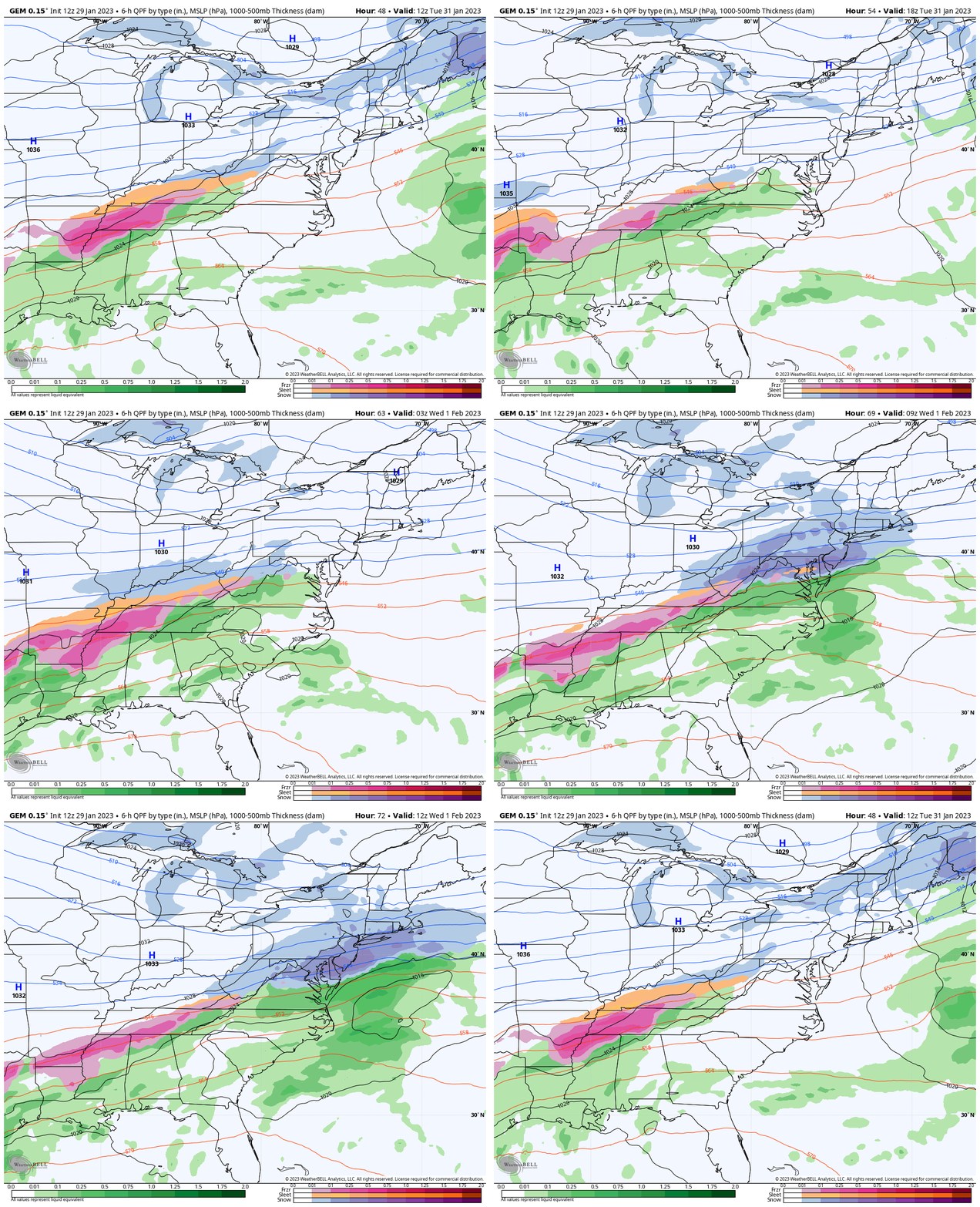
Canadian Model Notes
Pro: This model is one I dust off for the winter as it performs BEST when there is arctic air. It dominated with the 2 Polar Vortex intrusions. We had record cold in January and the all time coldest March day that year.
Con: On the other hand, this has had a tough time in regular patterns.
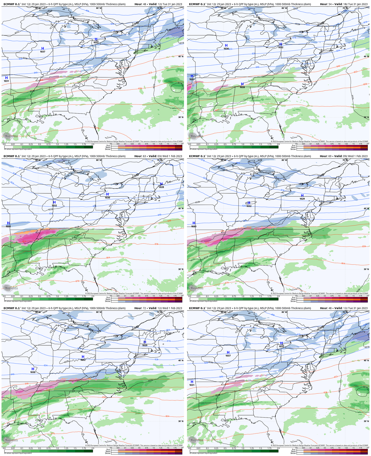
ECMWF Model:
Tuesday Morning to Wednesday Morning
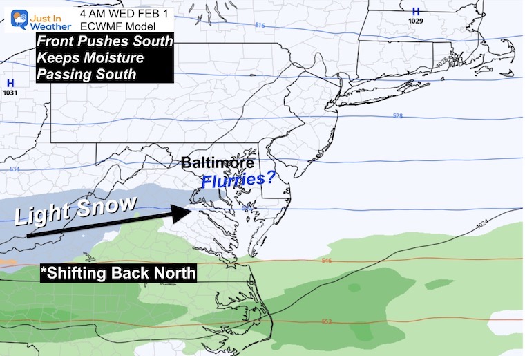
This pushes the front father south, keeping us dry? I have the question mark because after it showed a modest storm for us, it got lost. I have notice the trend back north in the last few days, so it may be showing the error I had mentioned in prior reports. If so, this trend back north may continue.
European Model Notes
Pro: This is the most reliable computer model guidance we have.
Con: It can overdo arctic air masses, letting them advance too far south, then trend back north. We have actually seen this with snow forecasts ending up warmer with rain. In this case, it could make the difference from dry to light snow being closer.
Let’s Compare 5 Model Snapshots
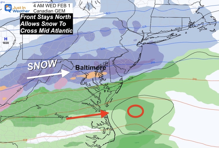
Canadian Model:
Recap: Shows us snow with the front remaining closer. This is the most robust model that I have been following. There is a bonus model that is similar I will add in below.
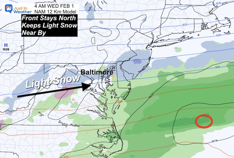
NAM 12 Km:
This is a lower resolution of the 3 Km Model I show, but allows a forecast farther out in time. This keeps the front also near Maryland, but only results in light snow.
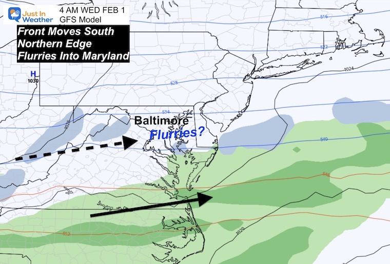
GFS Model:
This had dropped south, and seems to be showing a little remorse for that premature move. While only showing flurries, it keeps the front closer.
European Model
As shown above, this still has us mostly dry, but has backed up that progress of the front. I will be watching for that display of light snow or any shift back north. If we see that in the Monday model plots, then we might be seeing the Canadian hold its ground and the others playing catch up.
Bonus 5th Model: GRAF
This GRAF Model is an IBM Product only available to subscribers, and I do not pay for it so I don’t use it. However, if you watched my friend Tony Pann on my former TV station today, you may have seen him show this model. Both Tony and Tom Tasselmeyer have shown this model with credible results earlier this winter.
Latest run of the GRAF seems to like the idea of snow for the Baltimore Metro early Wed AM. It’s done well so far this winter. Are we going to break the streak? Stay tuned… #MdWx #SnowTrain pic.twitter.com/U3Q6SX1rxt
— Tony Pann (@TonyPannWBAL) January 29, 2023
Take Away:
I am not giving up on the snow chance this week. It is not a wishful outlook, but banking on the error I believe the main guidance is repeating. That is pushing arctic air too far east and south then it gets to the coast.
If that bias is on display, we should see the European and GFS back up the snow location over the next two model runs.
I will NOT show computer model snowfall. There are maps but I can not buy into that even for the snow favorable models. This has been such an unusual winter and I would rather wait longer to get it right, than jump on the most impressive images to get traffic.
I value my integrity and hope you do as well to know my reports are not click bait.
One final thing: I have clients who plow snow. Their businesses has been hurting, so my reports are as much for me and them as they are for you. It is best to be prepared rather that get caught by surprise if this plays out.
More to say for sure on Monday.
FITF – Faith in the Flakes
Latest Measurable Snow In Baltimore
Today Is 3rd Latest
- Feb 21 in 1973 (50 years ago)
- Feb 6 in 1914 (109 years ago)
- Jan 29 in 2023 (Today)
- Jan 25 in 1992 ( 31 years ago)
- Jan 25 in 1901 ( 122 years ago)
- Jan 23 in 1966 (57 years ago)
Also See:
Winter History: Low Snow And Late Starts
See my research based on Baltimore data since 1883.
Subscribe for eMail Alerts
Weather posts straight to your inbox
Sign up and be the first to know!

STEM Assemblies/In School Fields Trips Are Back
Click to see more and ‘Book’ a visit to your school
My Winter Outlook: Not A Typical La Niña!
I see many factors to support colder influence with multiple systems. Early and later in winter. Check it out.
October 27 Nor’easter Recap Still Breezy Then Next Storm Friday
Also See The Winter Outlook Series:
October 27 Nor’easter Recap Still Breezy Then Next Storm Friday
Farmer’s Almanac Comparison
September Starts Meteorological Autumn: Weather Climate Stats For Maryland at Baltimore
Triple Dip La Niña Winter
https://justinweather.com/2022/09/09/winter-outlook-2023-la-nina-triple-dip-expectations/
CONNECTION TO WINTER?
If you want a snowy winter, this is what you might want to look for in the rest of the tropical season.
Rainbow Ice Cave In Mt. Rainier A Very Rare Find: Photos And Video
Wooly Bear Caterpillars
https://justinweather.com/2022/10/25/winter-weather-outlook-from-the-wooly-bear-caterpillar/
Persimmon Seeds
Click to see Top 20 and MORE
Winter Weather Folklore Top 20 And More Outlook Signals From Nature For Cold And Snow
Normals And Records: Maryland and Baltimore Climate History
Please share your thoughts, best weather pics/videos, or just keep in touch via social media
-
-
Facebook: Justin Berk, Meteorologist
-
Twitter: @JustinWeather
-
Instagram: justinweather
-


