January 19 Rain Today Then Colder Pattern With Wintry Mix
January 19, 2023
Thursday Morning Report
Today is going to be a wet day. We have already begun with rain and will see more showers periodically throughout the day, culminating with a heavy line tonight. This may include some thunder.
We seem to now be in a pattern with a windy day following the storm, then another storm every 3 days. However, now the track is shifting east and south, allowing for more cold air. So the next two weather systems will introduce a more wintry mix. While there is a mention of snow, the cold air is marginal. This is not the big storm, and I am not ready to talk about stickage or accumulation as the ground is warm AND there will be a split with a rain line across the areas. However, we are changing weather pattern as advertised. Let’s take a look.
Headlines
- Today: Rain Today (Live radar below)
- Friday: Windy
- Next Two Storms: More Wintry Mix Involved Sunday and Wednesday.
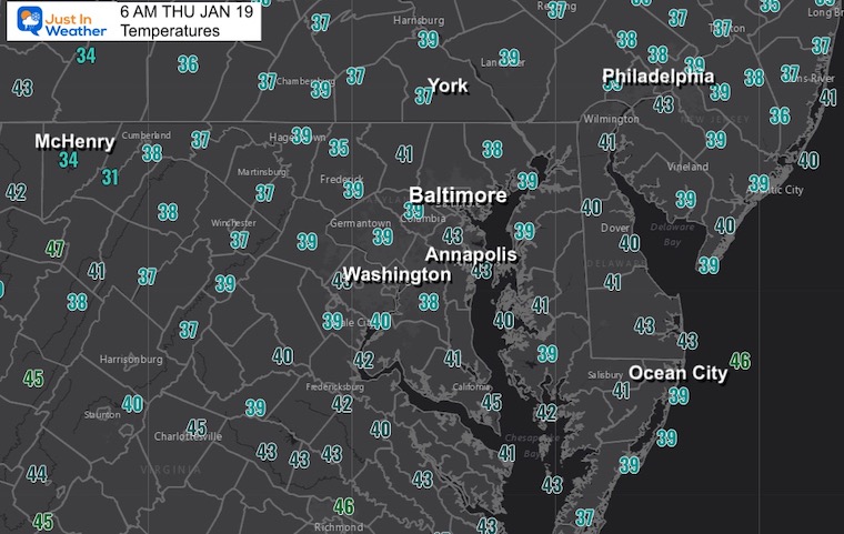
Morning Temperatures
It is chilly, but above freezing.
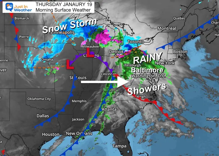
Morning Surface Weather
This latest storm system has brought steady rain into Pennsylvania, with showers to the south across Maryland and Virginia. These showers will expand during the day. To the west, a cold front has a line of heavy rain and some cells with thunder and lightning.
There is a snow part of this storm that has already produced 1 to 2 feet of snow across Nebraska, now spreading across Iowa, Minnesota, and Wisconsin.
This contrast has produced a lot of wind which will we get tomorrow.
Live Radar Widget
Radar Simulation: 7 AM to 10 PM
I believe this model is running a little slow, so we will have to adjust the timing during the day. It looks like it may be off by 1 to 2 hours.
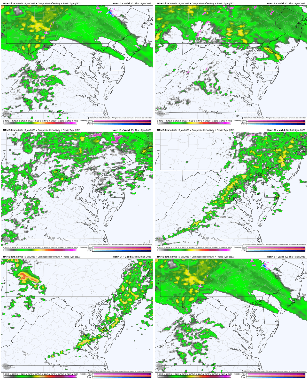
Snapshot Tonight
The time stamps shows 9 PM, but we may see this line between 7 PM and 8 PM. It will be a heavy band of rain with strong winds and perhaps some pockets of lightning and thunder.
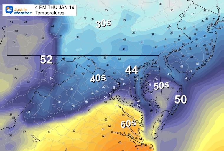
3 PM Temperatures
Subscribe for eMail Alerts
Weather posts straight to your inbox
Sign up and be the first to know!
CLIMATE DATA
TODAY January 19
Normal Low in Baltimore: 26ºF
Record -5ºF in 1994
SNOW: 7.7” 1961
Normal High in Baltimore: 43ºF
Record 69ºF 1951
Friday
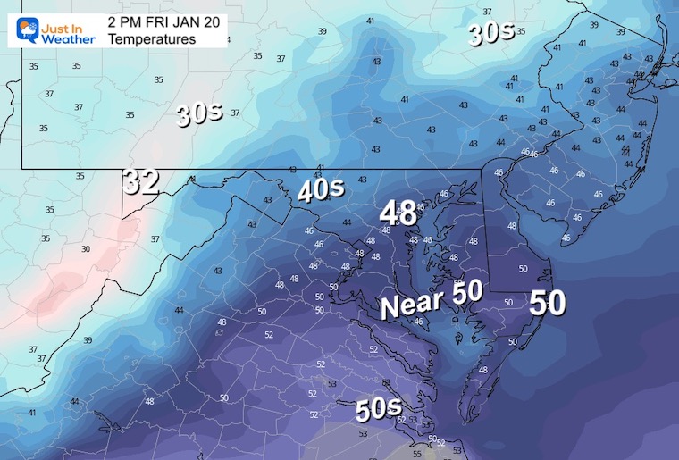
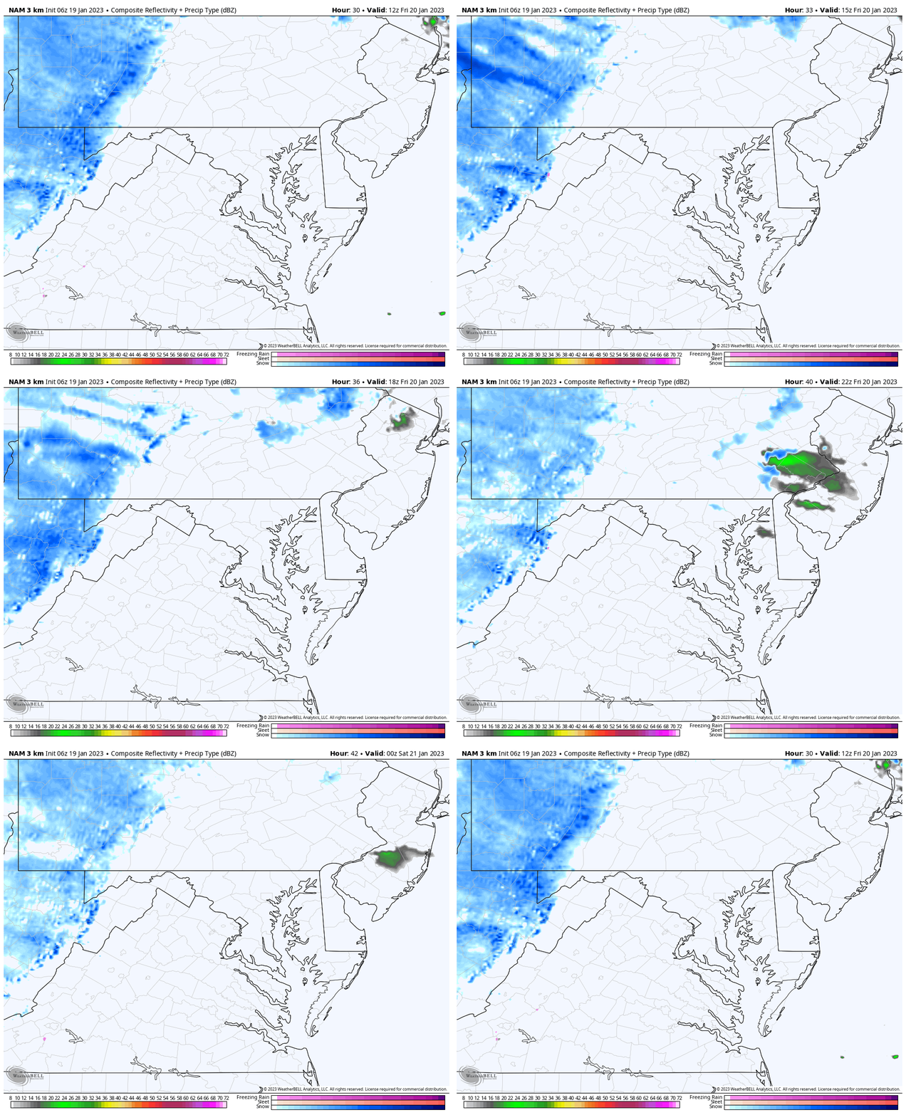
This will be a windy day with gusts OVER 30 mph.
Snow In The Mountains:
Radar Simulation: 7 AM to 7 PM
If you are headed to McHenry in MD, Seven Springs in PA, or Snowshoe in WV, the overall expectation is a fresh 1 to 3 inches of snow.
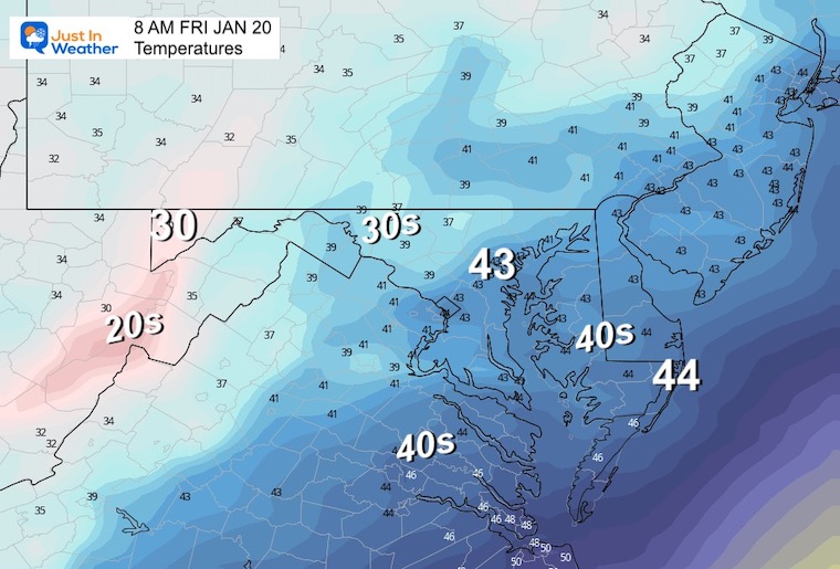
Morning Temperatures
Afternoon Temperatures
Storm Simulation
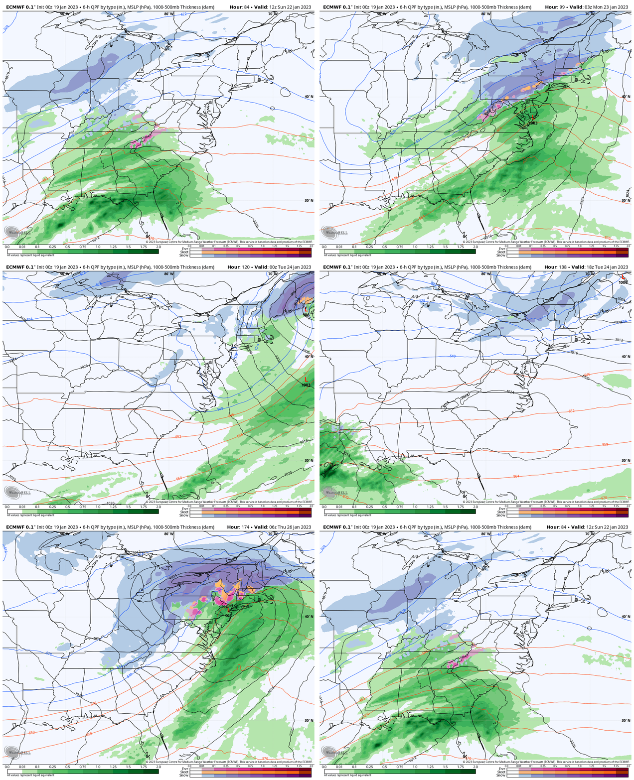
ECMWF Model 7 AM SUN to 7 AM THU
The European Model has been steady with this storm track. I am showing the next two weather systems to highlight the snow (blue) getting closer to the urban areas. Please see my thoughts and two key snapshots below.
My Thoughts:
We are lacking in deep cold air, so it is hard to see much more than a mix or even perhaps a brief accumulation farther inland. However, there may be some accumulation inland and more than likely an adjustment to the timing and tracks. So I am keeping an open mind and being honest with you: I don’t fully trust the modeling. This European prognostication is the best we have got for now.
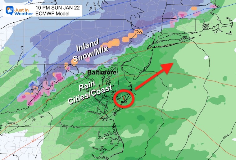
Snapshot: Sunday Evening
This looks like it will start with some wintry mix, especially inland. At this point it looks like the warm ground and marginal temps will not support stickage. Just local roads will be wet. There may be some stickage and road impact if you are traveling through PA or western Maryland. I will keep addressing that.
Snapshot: Wednesday
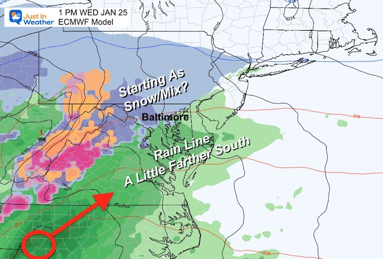
The next storm system will have colder air and perhaps a little more snow at the start. Just keeping this on the docket for our look at the week ahead.
7 Day Forecast
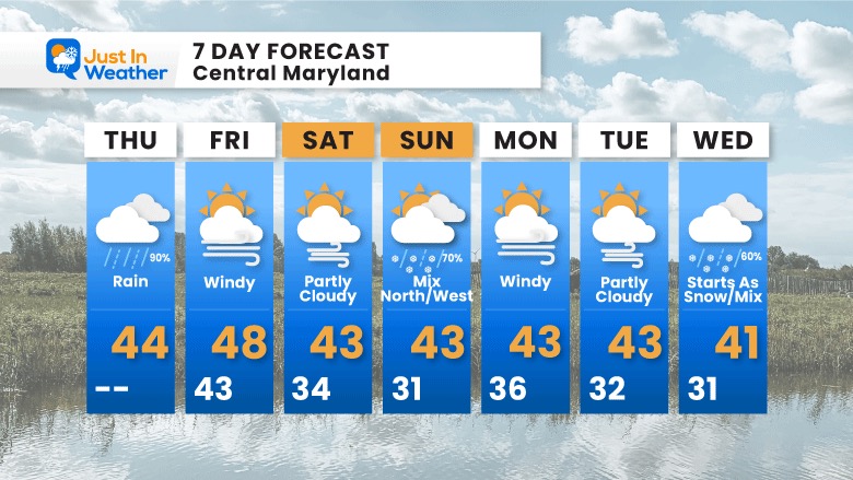
The numbers are more seasonal, but missing arctic impact… They do show a pattern change and we will see how that change evolves over the following few weeks. This is our opportunity to get winter to settle in and the global signals are still supporting it.
Faith in the Flakes Gear
What is Faith in the Flakes?
It began with my son in 2009
October 27 Nor’easter Recap Still Breezy Then Next Storm Friday
SNOWSTIX – Available Now
STEM Assemblies/In School Fields Trips Are Back
Click to see more and ‘Book’ a visit to your school
My Winter Outlook: Not A Typical La Niña!
I see many factors to support colder influence with multiple systems. Early and later in winter. Check it out.
October 27 Nor’easter Recap Still Breezy Then Next Storm Friday
Also See The Winter Outlook Series:
October 27 Nor’easter Recap Still Breezy Then Next Storm Friday
Farmer’s Almanac Comparison
September Starts Meteorological Autumn: Weather Climate Stats For Maryland at Baltimore
Triple Dip La Niña Winter
CONNECTION TO WINTER?
If you want a snowy winter, this is what you might want to look for in the rest of the tropical season. (You might be seeing a lot of commercial snow removal people out this Winter).
Rainbow Ice Cave In Mt. Rainier A Very Rare Find: Photos And Video
Wooly Bear Caterpillars
https://justinweather.com/2022/10/25/winter-weather-outlook-from-the-wooly-bear-caterpillar/
Persimmon Seeds
Click to see Top 20 and MORE
Winter Weather Folklore Top 20 And More Outlook Signals From Nature For Cold And Snow
Normals And Records: Maryland and Baltimore Climate History
Please share your thoughts, best weather pics/videos, or just keep in touch via social media
-
Facebook: Justin Berk, Meteorologist
-
Twitter: @JustinWeather
-
Instagram: justin


