January 6 Cooling Back Down And Realistic Look At Sunday Snow
January 6 2023
Friday Morning Report
Finally! The abnormally warm pattern has come to an end, and it did so with robust showers and some storms on Thursday. Yes, there was a persistent cluster of rain in the evening that produced thunder and some hail across central Maryland. Now the cool down is underway, or at least back to near normal.
Stop me if you heard this before: “If in winter there is thunder, snow may fall in one week or under”. We still have that system on Sunday that will try to produce snow, and I think I have a better idea on it, which I will elaborate on below.
Winter Lovers: This is NOT our pattern change, however the week ahead will be closer to average. That at least will allow colder nights for local mountains to blow snow for skiers and snowboarders.
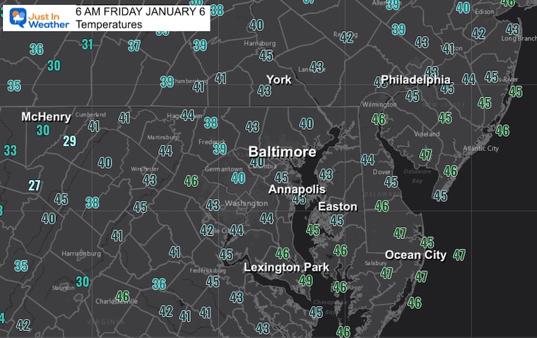
Morning Temperatures
Starting to cool down…
Surface Weather
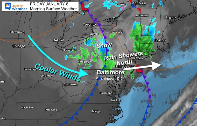
While temps have cooled a little, the actual cold front will be swinging through this morning. That is bringing a final push of showers, primarily across north central Maryland to Pennsylvania.
Snow showers will follow in the western mountains while the sky will try to clear in metro areas this afternoon.
Live Radar Widget
Tracking the rain near and north of the Maryland and Pennsylvania border around sunrise.
This produce is very sensitive. Rain is more likely falling under the brighter green shading. Sprinkles might be falling elsewhere.
Radar Simulation – NAM 3 Km Model
7 AM to 4 PM
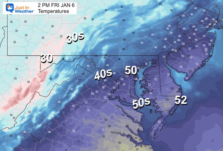
After the morning showers pass through, we should get into clearing and more sunshine in metro areas, however the temps will be much cooler than earlier this week. One hint of that will be the snow showers in western Maryland.
3 PM Temperatures
Subscribe for eMail Alerts
Weather posts straight to your inbox
Sign up and be the first to know!
CLIMATE DATA
TODAY January 6
Normal Low in Baltimore: 26ºF
Record 5ºF in 1904
SNOW: 3.4” 1989
Normal High in Baltimore: 44ºF
Record 72ºF 1950
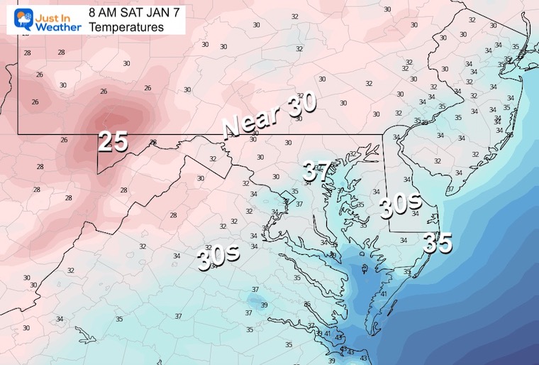
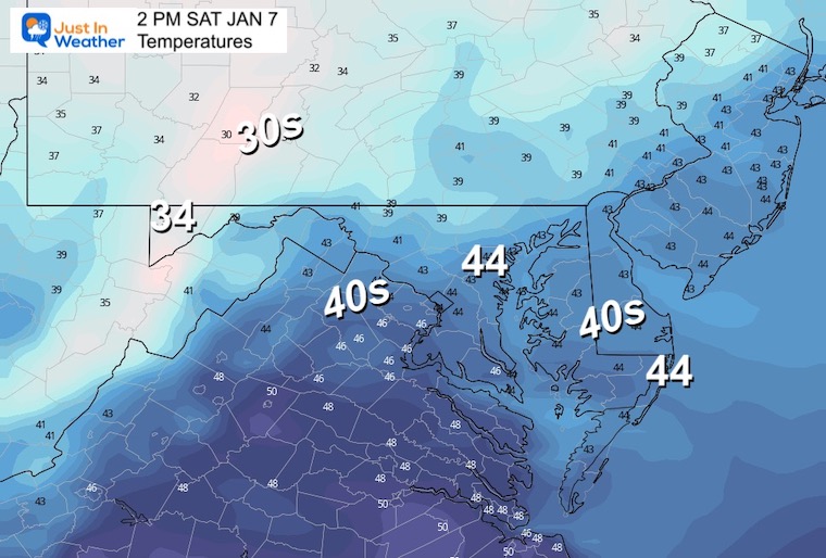
Saturday
Morning
Afternoon
Closer to seasonally average numbers.
Looking Ahead To Sunday
It is almost comical at this point: The GFS Model is still trying to emphatically produce a snow burst, while the European ECWMF is ‘Ho-Hum’ with light mix at best. The difference in location (GFS is farther north), and timing (GFS is faster).
Comparison
As I mentioned a few days ago, the ground temps are warm. So even with the more aggressive attempt at this short wave, stickage will be a struggle. With that said, we could get lucky with a brief burst of snow ‘falling’ and maybe laying on the grass inland.
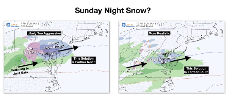
More than likely, there will be some hybrid between the models, leaning more towards the Euro result. Any slushy mix will trend towards a light rain as it ends Monday morning. That means, we should not be looking at impact for work or school. Not this round.
Model Animations:
GFS Model
7 AM SUN to 7 AM MON
This is the more aggressive development with a snow burst Sunday evening. This is in part due to seeing the energy more robust AND a little farther north tapping into colder air.
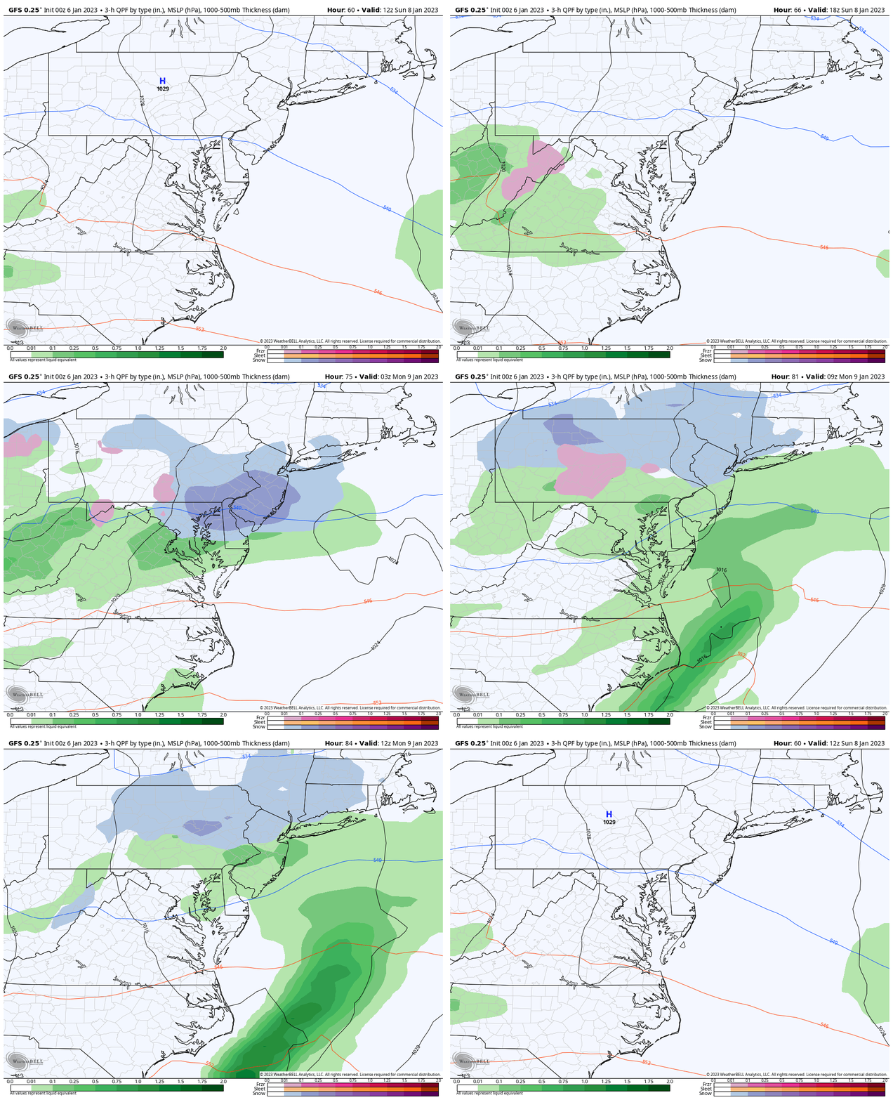
Snapshot Sunday Evening
As much as I would love to promote this, I believe it is a bit overdone. Even if it verifies, the ground temps suggest more melting than stickage.
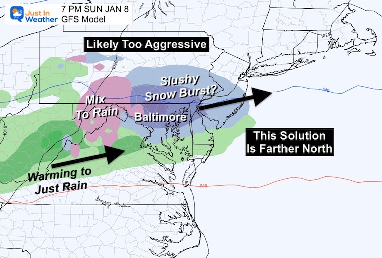
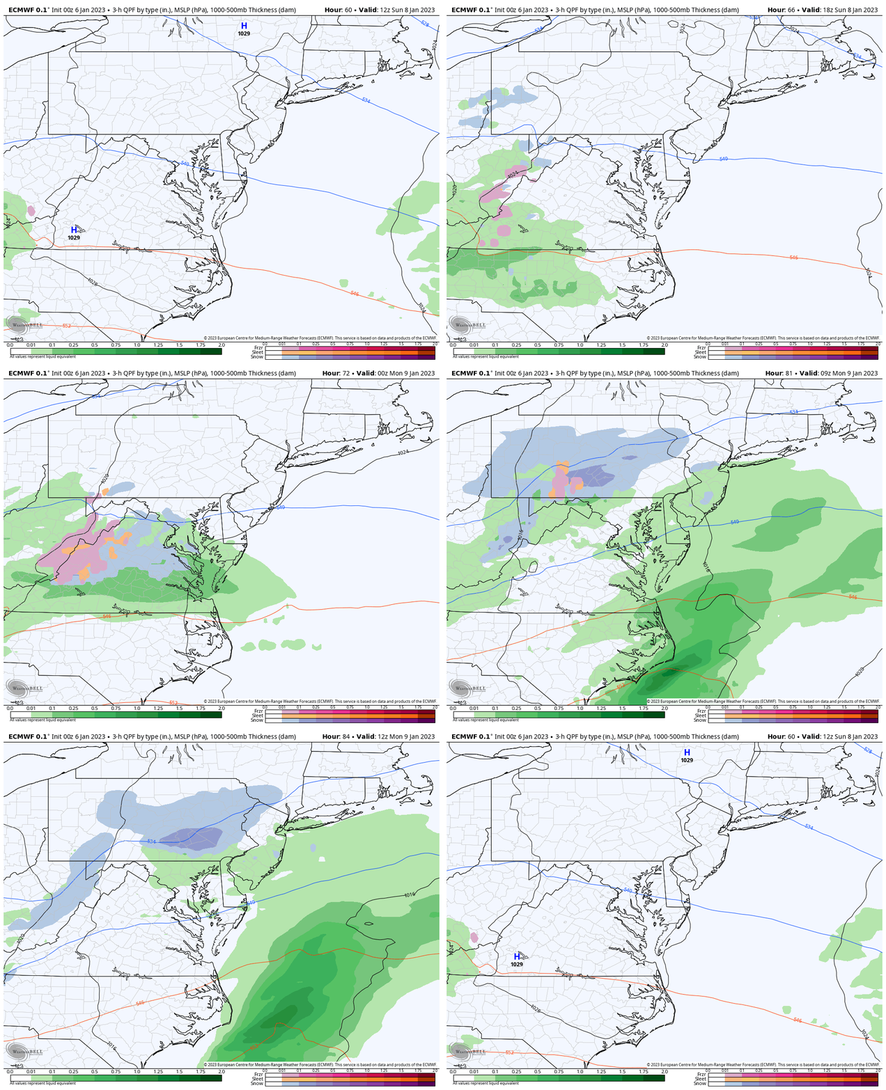
ECMWF MODEL
7 AM SUN to 7 AM MON
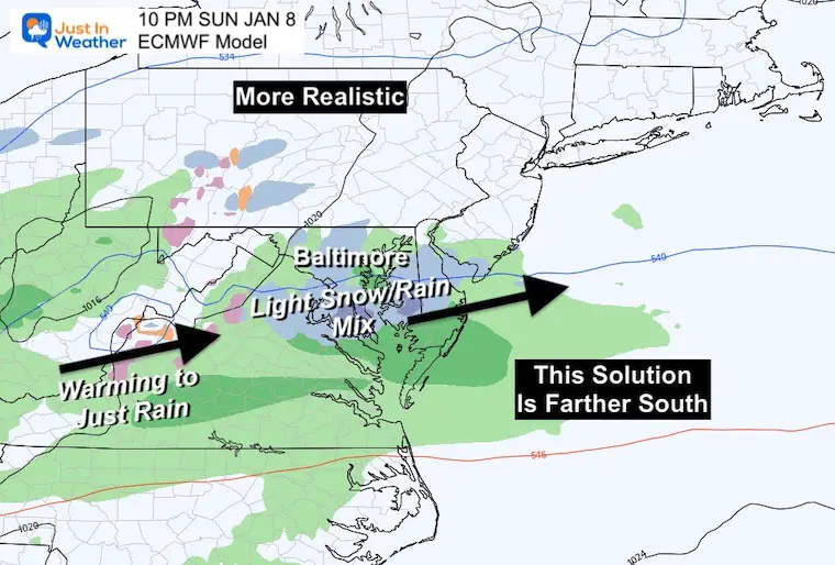
This is more than likely to be closer to what really happens. It is farther south, so not able to tap into as much of the marginally colder air.
I do believe the event may end up faster or closer to the GFS timing, but the output of rain/snow mix helps convey the lower impact on roads.
Snapshot Sunday Night
This is 3 hours later than the time frame for the GFS above, because it is slower bringing in the event. I think its best to suggest a rain/snow mix in the evening and at night, with little to no stickage for most of the region. However, if the snow wins for a few hours, we could see a coating on the grass. Especially west and north of the cities.
My Thoughts:
We will be trending closer to ‘average’ temperatures over the next week. This is NOT the pattern change. The modeling is still having trouble with the overall pattern, and I must say it is disappointing. But I know there are some very intelligent atmospheric experts that are losing sleep trying to see why the modeling is struggling. The truth of the matter is that we have low confidence with surface weather outputs beyond 3 to 5 days now. That does seem like a step backwards.
Going forward, there is still good reason to see a pattern change based on the global circulations and historical analogs. So I am sticking with a colder, wintry pattern for the latter half of January into February.
The atmosphere will remain active, and even in a mild winter pattern we can still get snow. Do not despair with this Extended Forecast showing only near seasonal temps. We have not yet reached that period for the pattern change, yet.
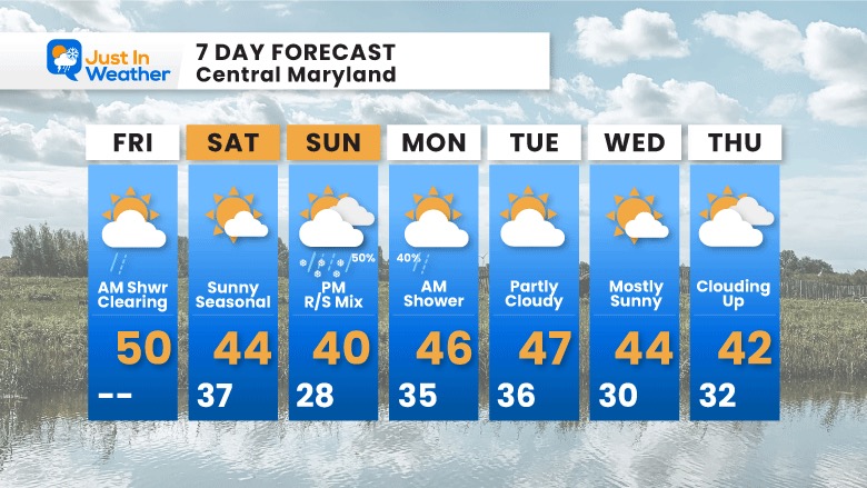
7 Day Forecast
Next week will be closer to normal. That is cooler, but not arctic cold. As I discussed in a few prior reports: The month will be mild, but trend more wintry for the latter part of January.
Faith in the Flakes Gear
What is Faith in the Flakes?
It began with my son in 2009
October 27 Nor’easter Recap Still Breezy Then Next Storm Friday
SNOWSTIX – Available Now
STEM Assemblies/In School Fields Trips Are Back
Click to see more and ‘Book’ a visit to your school
My Winter Outlook: Not A Typical La Niña!
I see many factors to support colder influence with multiple systems. Early and later in winter. Check it out.
October 27 Nor’easter Recap Still Breezy Then Next Storm Friday
Also See The Winter Outlook Series:
October 27 Nor’easter Recap Still Breezy Then Next Storm Friday
Farmer’s Almanac Comparison
September Starts Meteorological Autumn: Weather Climate Stats For Maryland at Baltimore
Triple Dip La Niña Winter
CONNECTION TO WINTER?
If you want a snowy winter, this is what you might want to look for in the rest of the tropical season. (You might be seeing a lot of commercial snow removal people out this Winter).
Rainbow Ice Cave In Mt. Rainier A Very Rare Find: Photos And Video
Wooly Bear Caterpillars
https://justinweather.com/2022/10/25/winter-weather-outlook-from-the-wooly-bear-caterpillar/
Persimmon Seeds
Click to see Top 20 and MORE
Winter Weather Folklore Top 20 And More Outlook Signals From Nature For Cold And Snow
Normals And Records: Maryland and Baltimore Climate History
Please share your thoughts, best weather pics/videos, or just keep in touch via social media
-
Facebook: Justin Berk, Meteorologist
-
Twitter: @JustinWeather
-
Instagram: justinweather


