January 5 West Coast Bomb Cyclone As Cooler Air Trending In The East
January 5 2023
Thursday Morning Report
We are now 5 days into the new year and every afternoon in Baltimore has reached the 60s. This is also expected today. However, we will be trending cooler and back to near normal this weekend.
This morning starts off a little damp and mild, with areas of fog. It will turn cooler this afternoon! But before we get deeper into our weather, I want to address the major storm hitting the West Coast.
Surface Weather
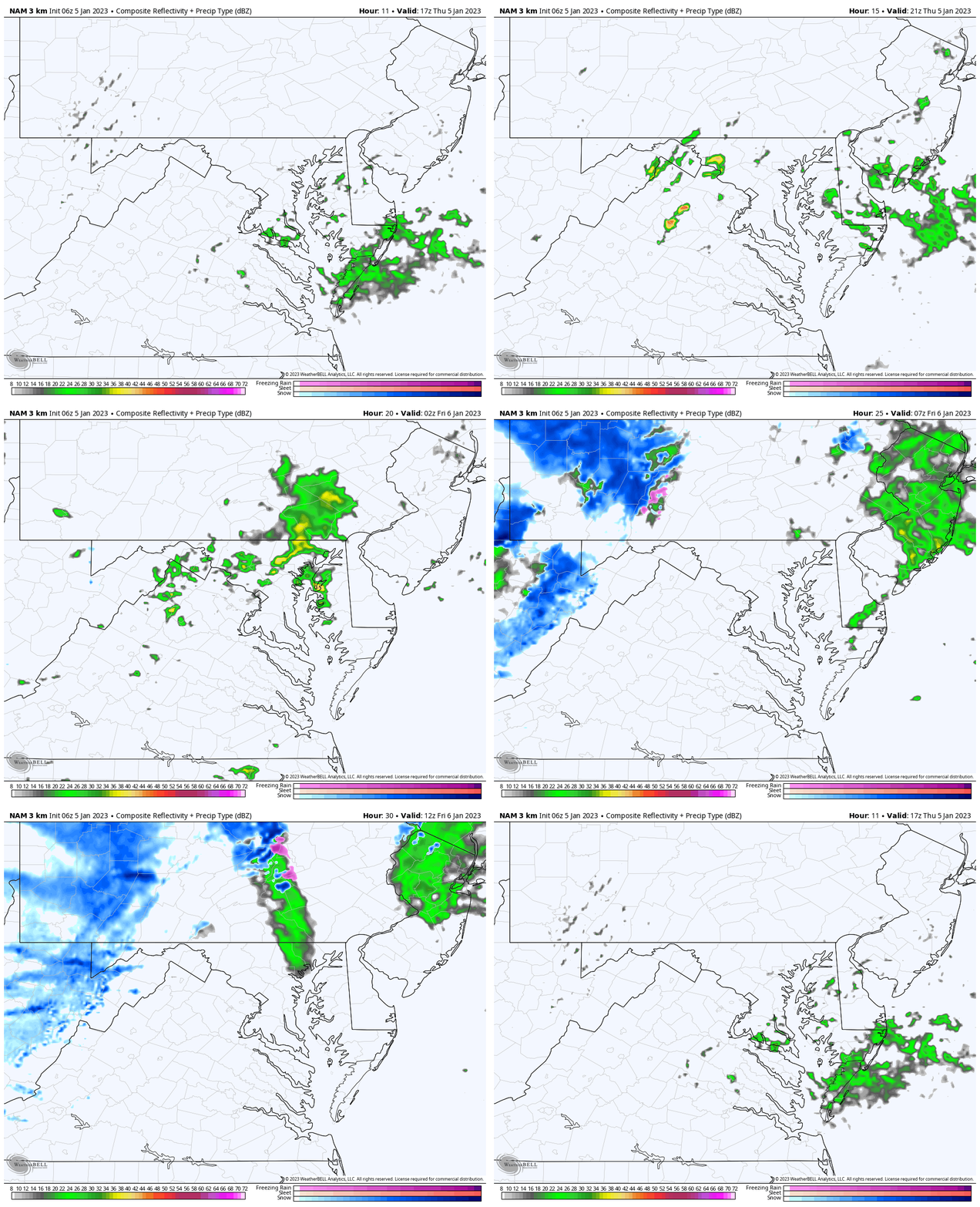
Locally, there is some patchy fog as the front is finally moving through, but we will have showers develop this afternoon as cooler air arrives. This includes snow in the Maryland mountains. See the simulation below.
That ‘Bomb Cyclone’ hitting Northern California is the real deal! Winds gusted over 85 mph overnight! Yes, over 2 inches of rain around Los Angeles, with up to 10 inches or more near and north of San Francisco. In the higher Sierra Nevada Mountains, snowfall forecasts for the week ahead are between 4 and 8 Feet! More detail on this extreme weather event below.
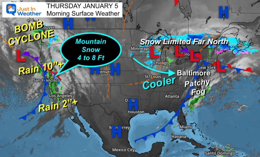
Bomb Cyclone
We’ve had a few of these over the past month, but this one off the Pacific Ocean is simply showing that the atmosphere is still charged up and will continue with an active winter…
What is truly impressive about this is the amount of moisture is more like an El Niño pattern, rather than a La Niña storm.
NOAA Storm Statements
(You may need to pinch and zoom in on the text)
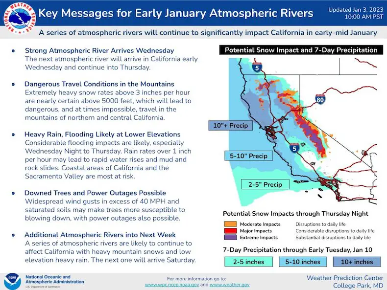
National Weather Service: San Francisco Bay Area
I am showing this because last week I used the word ‘Marvel’ at the Lake Effect Snow in Buffalo. Some people felt it was insensitive given the high death toll.
That term is used from a meteorological perspective, and NWS did so for this storm while acknowledging it is a life threatening event:
🛰Marvel at the satellite imagery this morning. Those asking, “Where’s the Storm”? It’s still coming. The rain this morning is not the main event so to speak. Heavier rain is expected later today. Blue dots are lightning flashes. #cawx pic.twitter.com/Q3E4xYur5m
— NWS Bay Area 🌉 (@NWSBayArea) January 4, 2023
Wind Gusts To 85 mph
This was reported last night…
Impressive wind showing up in Marin. Gusts up to 85 mph now (4:10-4:30)! #cawx pic.twitter.com/D2VSUN768s
— NWS Bay Area 🌉 (@NWSBayArea) January 5, 2023
Local Weather
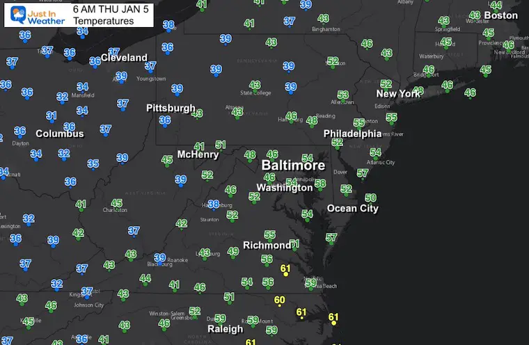
Morning Temperatures
I am showing a wider view this morning to highlight that while we remain mild in the mid 50s, the 30s in western PA and Ohio will be heading our way. We will start to nicely cool down this afternoon.
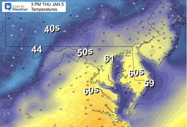
3 PM Temperatures
High temperatures may be between 1 PM and 3 PM, then cooling with the wind shift to the west.
Radar Simulation – NAM 3 Km Model
12 PM Thu to 8 AM Fri
Showers will expand this afternoon across Delmarva, then a second band west and north of Baltimore this evening.
Friday Morning: The final push of energy may arrive around daybreak Friday with this line of rain.
Note the blue: That is snow for Western Maryland and West Virginia where they may accumulate a few fresh inches. That will set up a good weekend for the ski areas.
Subscribe for eMail Alerts
Weather posts straight to your inbox
Sign up and be the first to know!
CLIMATE DATA
TODAY January 5
Normal Low in Baltimore: 26ºF
Record 1ºF in 1877
SNOW: 2.8” 2003
Normal High in Baltimore: 44ºF
Record 69ºF 1997
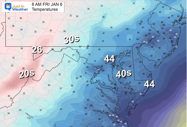
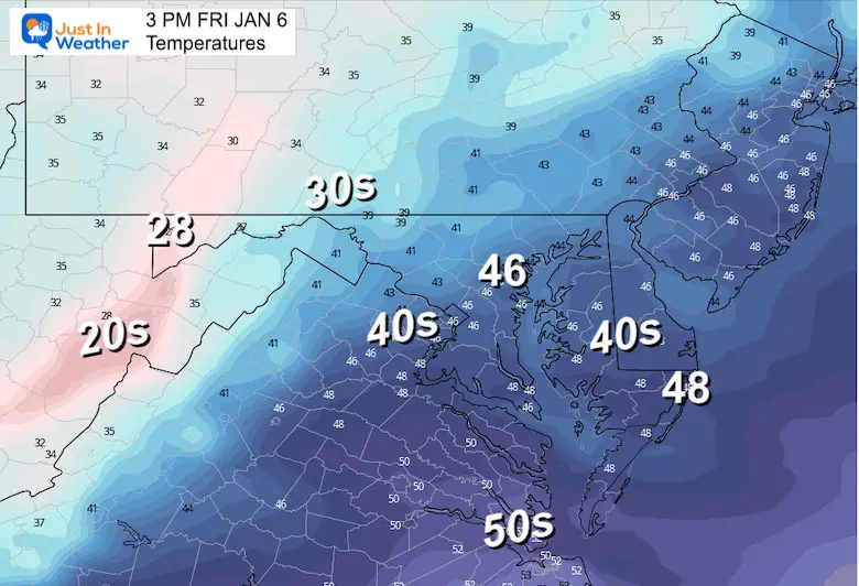
Friday
Morning
Still above average, but trending colder as we head through the day and weekend.
Afternoon
These readings are closer to ‘normal’.
Looking Ahead To This Weekend
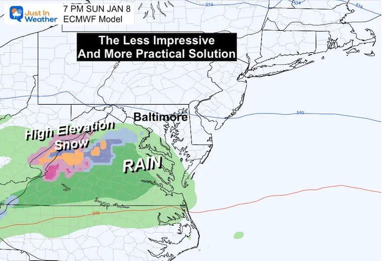
We are zeroing in on Sunday afternoon and evening. Regardless of the prior GFS snowy model or less snow European model solution, ground temps are too warm for this to be a local impact. Travel in the mountains however may be affected.
Storm Animation: ECMWF MODEL
7 AM Sunday to 7 AM Monday
I have lost faith in the GFS because it is all over the place. Here, we see the European Model still showing the Sunday event with higher elevation snow.
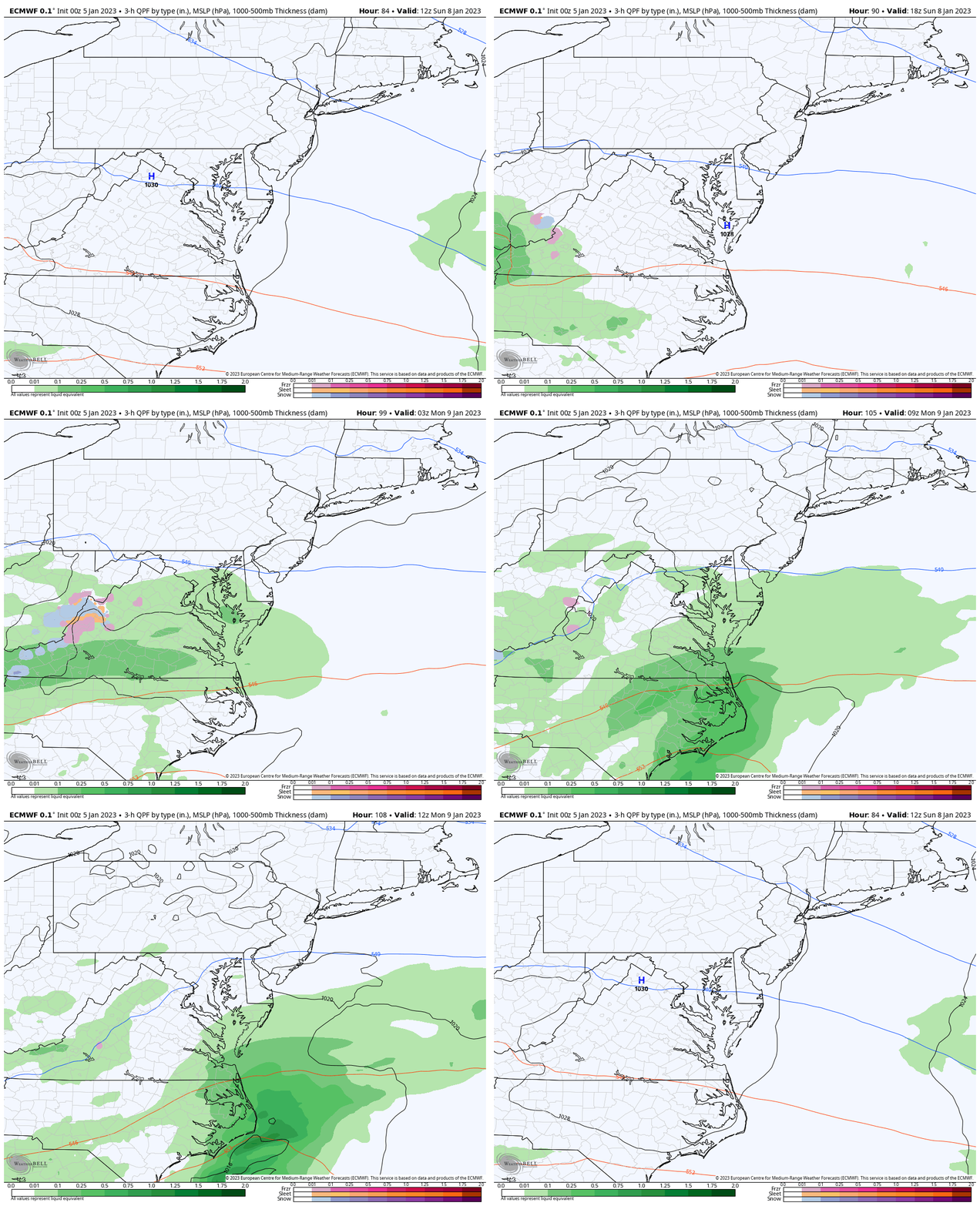
Snapshot Sunday Evening
I have been saying roads are too warm for stickage, except in higher elevations. But this event is more of an exercise in proving model guidance continues to be poor.
My Thoughts:
I am losing confidence in computer model guidance. There seems to be a step backward even with mid range events (3 to 5 days). For over a week, the global pattern suggested something would develop this weekend, even if not a major impact (too warm to stick). But there is still not a lock on how that will play out.
So going forward, there is good reason to see a pattern change based on the global circulations and historical analogs. So I am sticking with a colder, wintry pattern for the latter half of January.
The atmosphere will remain active, and even in a mild winter pattern we can still get snow. So do not despair with this Extended Forecast showing only near seasonal temps. We have not yet reached that period for the pattern change, yet.
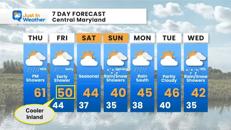
7 Day Forecast
I’ve highlighted Friday: I put 50ºF for BWI, but it will remain in the 40s for most inland from the cities and Bay.
Next week will be closer to normal. That is cooler, but not arctic cold. As I discussed in a few prior reports: The beginning of the month will be mild, and we just had that. This is the first step back to reality, and we will wait for the middle of the month for more signals to send in the winter cavalry.
Faith in the Flakes Gear
What is Faith in the Flakes?
It began with my son in 2009
October 27 Nor’easter Recap Still Breezy Then Next Storm Friday
SNOWSTIX – Available Now
STEM Assemblies/In School Fields Trips Are Back
Click to see more and ‘Book’ a visit to your school
My Winter Outlook: Not A Typical La Niña!
I see many factors to support colder influence with multiple systems. Early and later in winter. Check it out.
October 27 Nor’easter Recap Still Breezy Then Next Storm Friday
Also See The Winter Outlook Series:
October 27 Nor’easter Recap Still Breezy Then Next Storm Friday
Farmer’s Almanac Comparison
September Starts Meteorological Autumn: Weather Climate Stats For Maryland at Baltimore
Triple Dip La Niña Winter
CONNECTION TO WINTER?
If you want a snowy winter, this is what you might want to look for in the rest of the tropical season. (You might be seeing a lot of commercial snow removal people out this Winter).
Rainbow Ice Cave In Mt. Rainier A Very Rare Find: Photos And Video
Wooly Bear Caterpillars
https://justinweather.com/2022/10/25/winter-weather-outlook-from-the-wooly-bear-caterpillar/
Persimmon Seeds
Click to see Top 20 and MORE
Winter Weather Folklore Top 20 And More Outlook Signals From Nature For Cold And Snow
Normals And Records: Maryland and Baltimore Climate History
Please share your thoughts, best weather pics/videos, or just keep in touch via social media
-
Facebook: Justin Berk, Meteorologist
-
Twitter: @JustinWeather
-
Instagram: justinweather


