December 15 2022
Thursday Night Update
I want to take this opportunity to address the storm we just had, the little disturbance this weekend, and the much larger pattern adjustment next week. We’ve already discussed this long-range look with the Deep Negative North Atlantic Oscillation AND a wobbling Polar Vortex. The net result will unload arctic air to the Eastern US and is very likely to develop a coastal winter storm in the process.
This is all 9 days away, which is beyond my normal look at storm development. The reasons I am talking about it this early I determined were important. First, this potential big event will be just before Christmas. There is an excitement component, but also the need to consider everyone traveling that may want to plan ahead.
The other issue is that the arctic air in our poor economic situation will undoubtedly affect many people who struggle to pay for heat. This will tax the oil supply and is already a consideration in market commodities trading.
On the flip side, I do NOT believe in giving snow specifics this early. If you have seen snow totals and or timing on an app or from a weather page, look away. There is no way to confirm, or any reason to lock in on numbers this far out.
For me for now: I feel comfortable, based on trends, to suggest next Thursday and Friday as the window to pay close attention to.
Let’s start with the storm tonight:
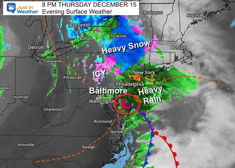
Evening Surface Weather
Low pressure is crossing the Lower Delmarva and will dump over a foot of snow to a large area from the Poconos to New England. Here is what I learned from this:
- The GFS Model was too cold for us.
- Our trend of systems moving in and out faster has continued.
- Precipitation Totals have continued to be forecast too high by models.
- The ground was too warm to support icing this morning, but it is sufficiently cooling. That progress will be considered in the week ahead.
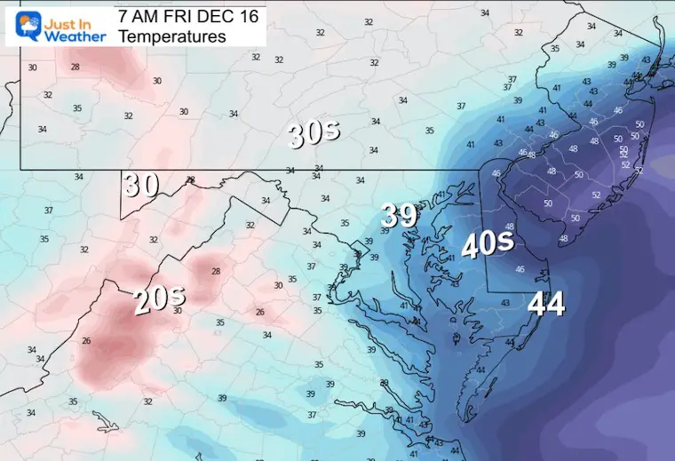
Temperatures
This is centered on the Mid Atlantic through Saturday. I am showing this for posterity and to note that the cold air is NOT here yet. We remain below average, but the real cold stuff is on the way.
CLIMATE DATA For Baltimore
TODAY December 16
Normal Low in Baltimore: 30ºF
Record 10ºF in 1951
SNOW: 6.0” 1973
Normal High in Baltimore: 47ºF
Record 71ºF 1971
Friday Morning
The really cold air is not here yet.
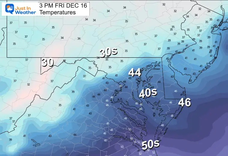
Friday Afternoon
High temperatures will signal back below average temperatures.
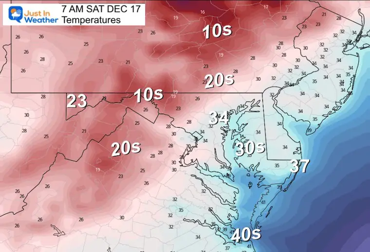
Saturday Morning
Trending back closer to ‘normal’.
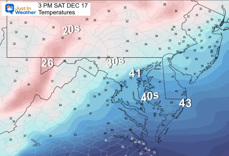
Saturday Afternoon
Back below normal and maybe some flurries.
Weekend Flurries?
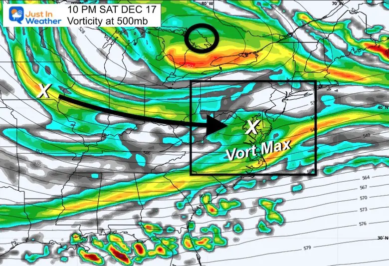
I mentioned this for a few days and most weather apps don’t show it. I do not expect accumulation, but the jet stream will be very active and send two Vort Maxes our way. These are energy impulses that can enhance cloud formation and showers east of the mountains. In this case, perhaps some ambience flurries.
Jet Stream Animation
Friday Morning to Sunday Night
Key Timeframes:
Saturday Night
A weak Vort Max will pass through central Maryland bring a small chance for flurries.
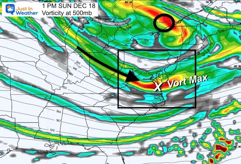
Sunday Afternoon
A stronger Vort Max has a better chance to build clouds and flurries.
Looking Ahead To The Big Show
Jet Stream Height Anomalies 7 AM Tue Dec 20 to 7 AM Sat Dec 24
Snapshot Friday Night December 23
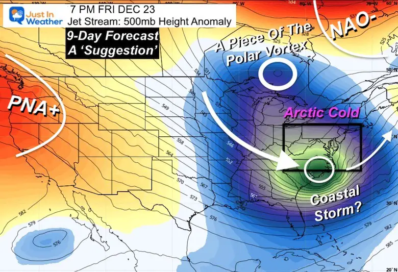
This looks like an ideal set up for winter storm, but please keep in mind this is a forecast 9 days into the future.
The PNA (Pacific-North American Index) is Positive and sending energy into the Pacific Northwest.
The NAO (North Atlantic Oscillation) is still Negative and under the influence of a Strong Greenland Block. This will help move very cold air to the south
On larger plots this looks like a piece of the Polar Vortex has broken off and will drop into southern Ontario, Canada. Then help to send Arctic Air into the US.
A shortwave rounding the Deep Trough is what could provide the energy for a large coastal winter storm. My ‘?’ is simply of the location and timing. The overall pattern is highly supportive of something impressive developing.
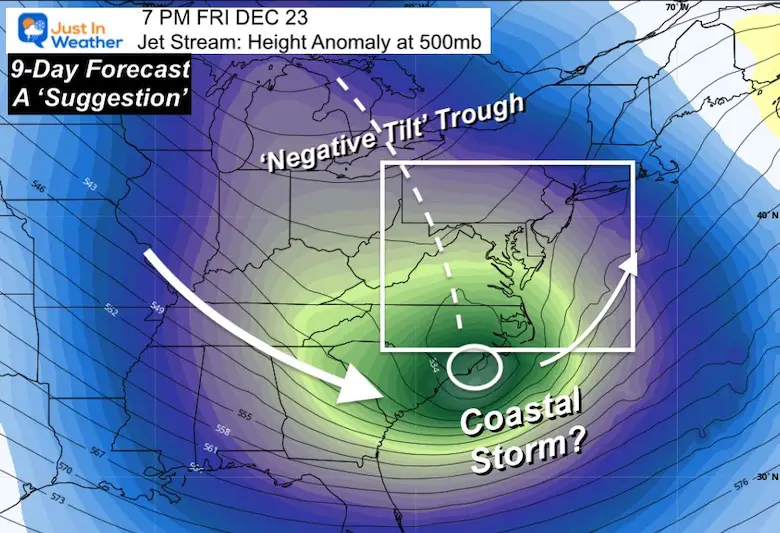
Closer Look
The trough axis shows a negative tilt with a very deep digging of that short wave to coastal North Carolina. This is a prime location for baroclinic enhancement of a strong Low Pressure.
The Negative Tilt is an orientation of an upper level low that will pivot a Surface Storm North up the Coast.
The very cold air and location both support a large area of winter precipitation.
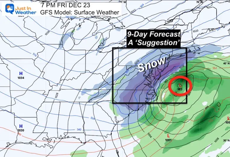
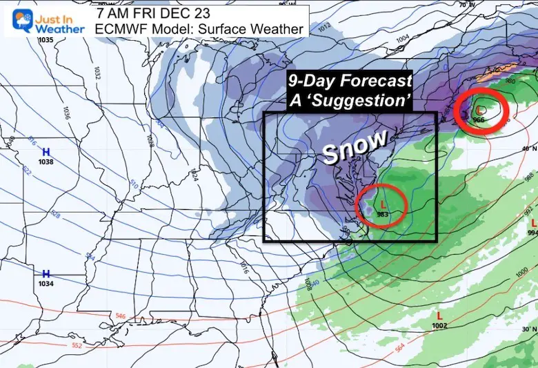
Surface Weather ‘Suggestion’ Next Friday Night
This is where we see that the ‘idea’ of a storm has two different translations. Please note this was generated earlier today and is looking 9 Days into the future!
The GFS Model shows a single concentrated Low off the Mid Atlantic Coast. Meanwhile the European Model is faster with a double barrel system. The Canadian Model doesn’t even have a storm, so I am not showing that for now. Let’s explore:
GFS Model
A centralized Low Pressure with a 983 mb Low located of the North Carolina Coast. This shows snow beginning earlier in the day for our region and the storm passing to our south and farther off the coast.
European ECMWF Model
This model actually is faster/earlier with the snow. It has an initial Low at 994 mb passing in the same location as the GFS (above) a day earlier, followed by a second Low Friday morning seen here. This phasing solution broadens the impact to a large area, and expands the timing of the event over two days.
My Thoughts:
You will hear a lot of people talk about this over the next few days. Many of us see the same models and it is easy to show the boldest images!
I still prefer the European long range over the GFS. Having two leaders does help for comparing. I DO NOT and WILL NOT suggest snow amounts until we are within 3 days of the event. Even then, the first call will be more for timing and general storm intensity.
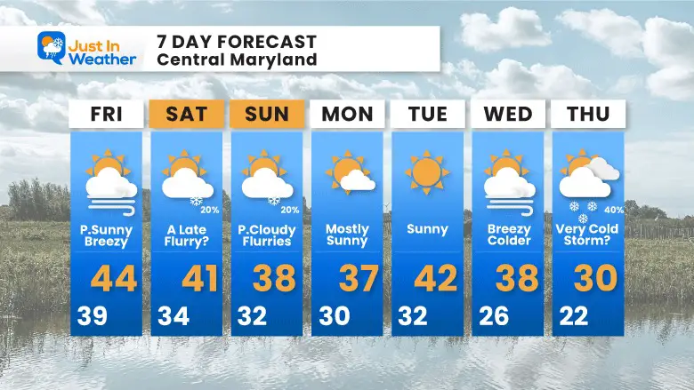
7 Day Forecast (for Baltimore)
Let’s not get ahead of our skis and promise anything. The pattern supports ‘something’! It will impact a lot of people and true winter should be felt before Christmas. That’s where we should start more than one week away. Why? Because this storm is barely a suggestion on my 7-Day Forecast yet.
Faith in the Flakes.
Faith in the Flakes Gear

What is Faith in the Flakes?
It began with my son in 2009
October 27 Nor’easter Recap Still Breezy Then Next Storm Friday
SNOWSTIX – Available Now

STEM Assemblies/In School Fields Trips Are Back
Click to see more and ‘Book’ a visit to your school

My Winter Outlook: Not A Typical La Niña!
I see many factors to support colder influence with multiple systems. Early and later in winter. Check it out.
October 27 Nor’easter Recap Still Breezy Then Next Storm Friday
Also See The Winter Outlook Series:
October 27 Nor’easter Recap Still Breezy Then Next Storm Friday
Winter Outlook 2023 La Niña Triple Dip Expectations
Farmer’s Almanac Comparison
September Starts Meteorological Autumn: Weather Climate Stats For Maryland at Baltimore
Triple Dip La Niña Winter
Winter Outlook 2023 La Niña Triple Dip Expectations
CONNECTION TO WINTER?
If you want a snowy winter, this is what you might want to look for in the rest of the tropical season. (You might be seeing a lot of commercial snow removal people out this Winter).
Rainbow Ice Cave In Mt. Rainier A Very Rare Find: Photos And Video
Wooly Bear Caterpillars
https://justinweather.com/2022/10/25/winter-weather-outlook-from-the-wooly-bear-caterpillar/
Persimmon Seeds
Winter Weather Outlook: Persimmon Seeds And Snow Folklore
Click to see Top 20 and MORE
Winter Weather Folklore Top 20 And More Outlook Signals From Nature For Cold And Snow
Normals And Records: Maryland and Baltimore Climate History

Please share your thoughts, best weather pics/videos, or just keep in touch via social media


