Snow Cover Now At 56 Year High In The Northern Hemisphere
November 28 2022
Does it even seem possible that our planet may have the most snow cover to date on modern record? We will be looking at the Northern Hemisphere as a whole and areas with any snow cover. So that epic Lake Effect Snow Storm last week was impressive, but only covers about 1% of the area that includes the USA, Canada, Europe, Russia, and northern Asia.
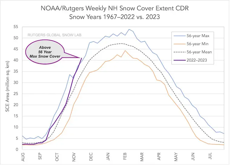
It may seem far-fetched when many of us have not seen snow yet, and some are convinced we don’t see much anymore. This nugget of data may be enough to put you over the top with anticipation for the winter ahead. The snow cover across the Northern Hemisphere has reached its highest level since measurements began in 1967 by NOAA and Rutgers University. It is currently above the 56-year mean! The supporting data is below, along with links to follow up directly on your own.
If you are a snow lover like me, this is very exciting and puts our Faith in the Flakes into full force. On the flip side, this does bring up a sincere concern as well. A cold and snowy winter combined with high energy prices and other economic (inflation) factors may be difficult for many to afford.
Record Snow Measurements
The historic Lake Effect Snow across western and northern New York State in the middle of November was a headline grabber. We will begin with that, but there was much more across the Northern Hemisphere.
Historic Lake Effect Snow
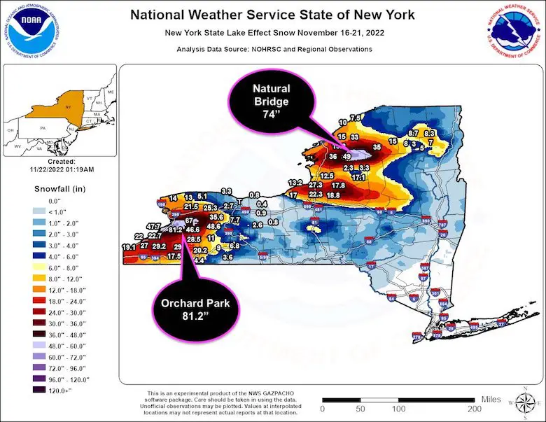
Let’s back up to just a week ago when the nation was glued to updates of obscene snow measurements outside of Buffalo, NY. Orchard Park (home of the Buffalo Bills) led the charge off Lake Erie with 81.2 inches, most of which fell in two days. Meanwhile, the Lake Ontario band pushed 74 inches of snow up the Tughill Plateau to Natural Bridge, NY.
Something Interesting
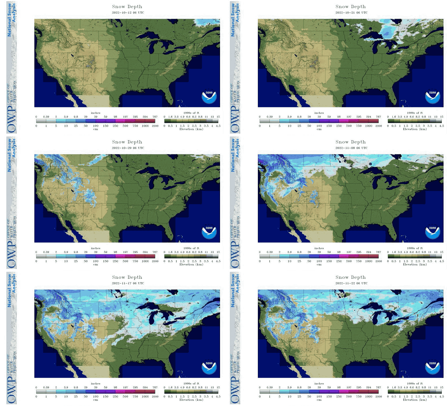
The Lake Effect Event was from November 16 to 21, 2022. However, other parts of the US had their snow melting at that time. It is important to note that while one area can boom, others can be melting away.
Daily Snowfall October 11 to November 22, 2022
US Covered By Snow
- On November 16: 41.1%
- On November 21: 29.6%
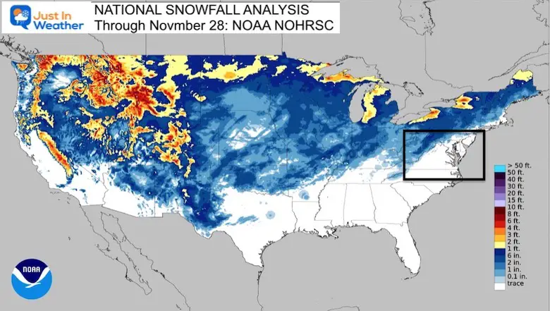
National Snowfall Analysis Through November 28
Notice the orange and red of over 3 to 4 feet of snow. Beyond the Lake Effect event in New York, check out the heavy snow that has fallen across the Rockies.
Record Snow Cover Extent
This is the fun part. Since 1967, NOAA has worked with The Rutgers University Global Snow Lab to measure the extent of snow across the globe. Sounds like a dream job, right?
In the 56th year, the cover of snow has reached beyond the previous high!
As of November 28, the Snow Coverage Extent is over 41 million square kilometers.
Looking at the chart, this current snow is almost one full month ahead of schedule.
Subscribe for Updates
Weather posts straight to your inbox
Sign up and be the first to know!
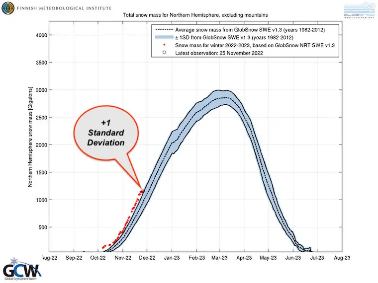
Snow Mass as of November 25
The Finnish Meteorological Institute shows the Northern Hemisphere snow mass is 1 Standard Deviation ABOVE the mean.
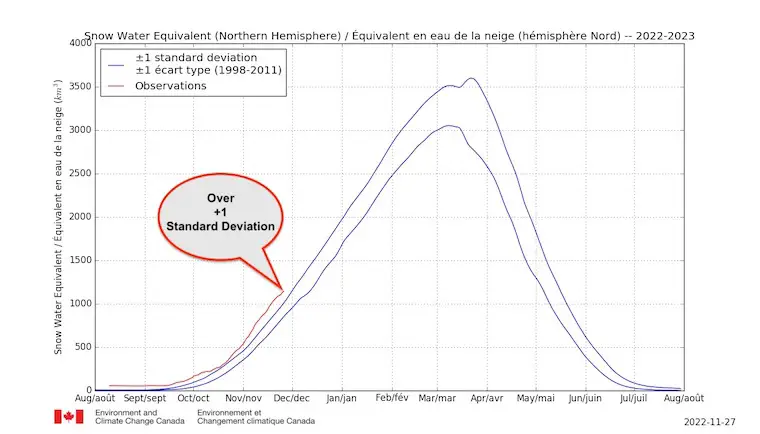
Snow Water Equivalent
The Environment and Climate Change Canada program shows the Northern Hemisphere snow water equivalent is 1 Standard Deviation ABOVE the mean.
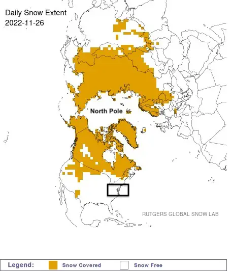
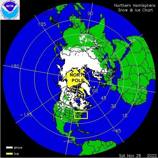
Snow Maps As of November 26
The Rutgers Global Snow Lab map…
NOAA Map shows the same data with a little more resolution. Both could use a little modern upgrade.
Sea Ice and Snow Depth
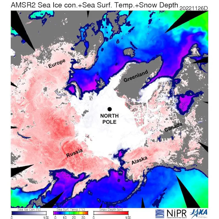
The National Institute of Polar Research combines the sea ice, water temperatures (where ice may form soon), and snow depth. All of these are factors that can increase planetary albedo, which is a reflection of solar energy back to space off the white covered surface.
Arctic Sea Ice
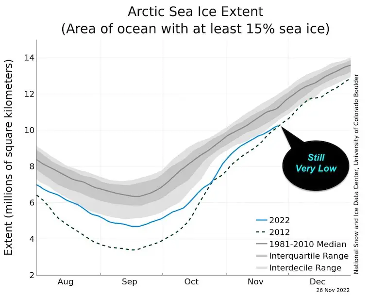
This is still troubling. The National Snow and Ice Data Center at the University of Colorado continue to measure Arctic sea ice well below the last 30-year average. This is the time of year with little to no sun and intense cold, where the ice cover can grow rapidly. But at this point, it is below 1 Standard Deviation.
The positive spin is that more snow across the continents can enhance the cold air masses, which can expand the cold and perhaps enhance sea ice growth.
Note: Ocean Water is salty and freezes at a lower temperature than fresh water. This begins at 29ºF.
Great Lakes Surface Analysis
Water Temperatures and Ice Cover
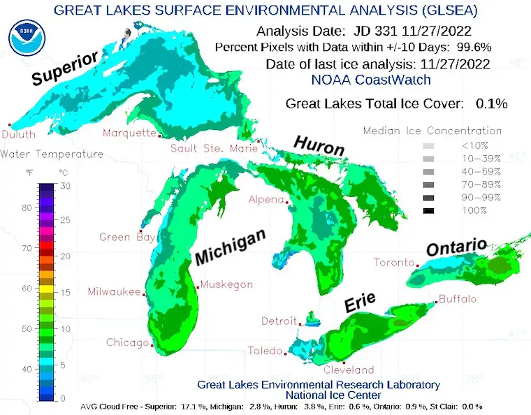
No ice yet and temperatures range from near 40ºF to mid 50s.
This was the observation on November 27, 2022. This will be a great tool to continue tracking through winter. The water temperature is a factor with available Lake Effect Snow Events. When ice forms, that mechanism shuts down.
Lake Erie is the most shallow of all the lakes and tends to freeze over first.
Resource Links
Hemisphere Snow: World Meteorological Organization
National Snow Analysis
NOAA Nation Operational Hydrologic Remote Sensing Center
Arctic Sea Ice
National Snow and Ice Data Center
Great Lakes Temperature and Ice
NOAA – Great Lakes Environmental Research Laboratory
NEW Faith In The Flakes Gear
Recent Related Articles
My Winter Outlook: Not A Typical La Niña!
I see many factors to support colder influence with multiple systems. Early and later in winter. Check it out.
October 27 Nor’easter Recap Still Breezy Then Next Storm Friday
October 27 Nor’easter Recap Still Breezy Then Next Storm Friday
Also See The Winter Outlook Series:
Farmer’s Almanac Comparison
September Starts Meteorological Autumn: Weather Climate Stats For Maryland at Baltimore
Triple Dip La Niña Winter
CONNECTION TO WINTER?
If you want a snowy winter, this is what you might want to look for in the rest of the tropical season. (You might be seeing a lot of commercial snow removal people out this Winter).
Rainbow Ice Cave In Mt. Rainier A Very Rare Find: Photos And Video
Wooly Bear Caterpillars
https://justinweather.com/2022/10/25/winter-weather-outlook-from-the-wooly-bear-caterpillar/
Persimmon Seeds
Click to see Top 20 and MORE
Winter Weather Folklore Top 20 And More Outlook Signals From Nature For Cold And Snow
STEM Assemblies/In School Fields Trips Are Back
Click to see more and ‘Book’ a visit to your school
Please share your thoughts, best weather pics/videos, or just keep in touch via social media
-
Facebook: Justin Berk, Meteorologist
-
Twitter: @JustinWeather
-
Instagram: justinweather


