


Winter Weather Advisory Sunday As Snowfall In Two Parts Affecting Two Different Areas
Saturday Evening Update January 17 2026 One thing I carry after all of my years of forecasting: If one model does a really good job in an active pattern, then…
April 27 2022
Wednesday Morning Report
Cold air is filling in now with a brand new air mass for us. The Eastern US is in a late winter-like pattern. This will include a chilly wind with Lake-Effect showers developing. The net result will keep temperatures well below average, including overnight temperatures down into the 30s or colder. That is what has prompted a Freeze Watch, while a wider net can be cast for like frost over the next two mornings.
A warm up will begin by Sunday and early next week, which will include the return of thunderstorms as well.
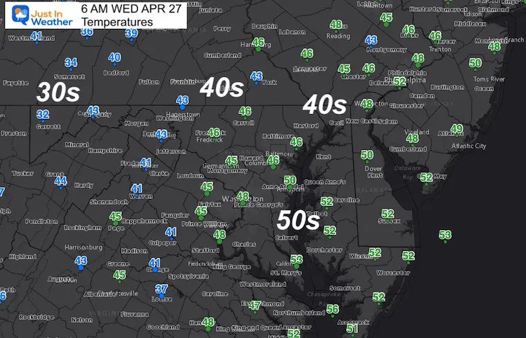
Normal Low in Baltimore: 46ºF
Record 35ºF in 2001
Normal High in Baltimore: 69ºF
Record 92ºF 1994
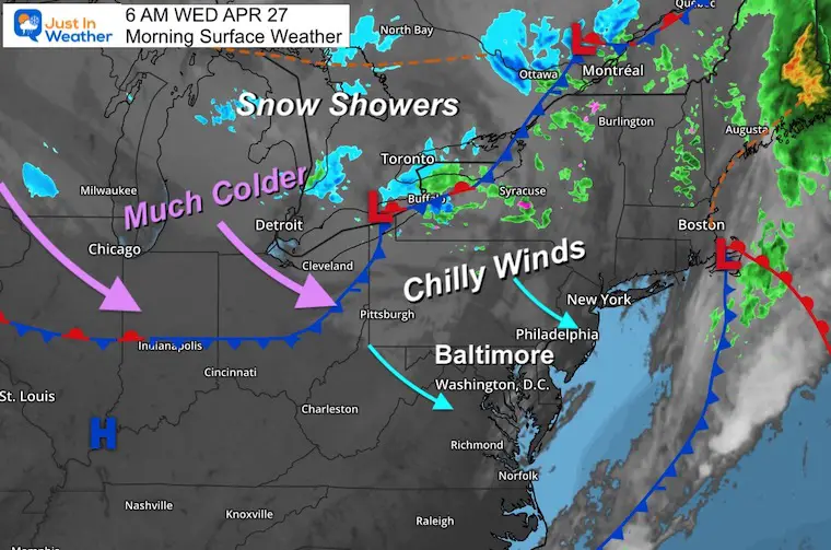
Strong chilly winds from the Northwest will average close to 20 mph, with gusts up to 35 mph.

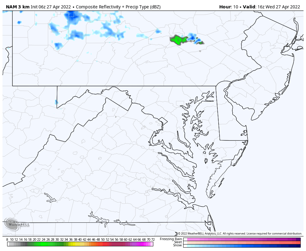
This is not a major factor today, but north and west of Baltimore will turn partly to mostly cloudy with the Lake Effect winds machine, which may produce some showers.
NAM 3Km Model Simulation Noon to 8 PM

With a clearing sky and light winds, temps will TANK tonight. This is the first level of awareness. This region is likely to be upgraded to a Freeze Warning, with the addition of a Frost Advisory for a larger area… especially inland from the water.
Take the time during the afternoon to cover your sensitive plants and bring in potted plants.
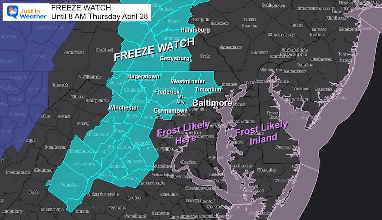
This is the coldest potential outlook showing the freezing line very close to Baltimore.
The most important take away is that many inland areas may reach the 20s. That means freezing for many hours, increasing the threat to plants.
Also, mid 30s will reach deep into Southern Maryland and even the beaches. So most of our region has the chance for Frost Thursday morning, which will be a threat to newly sprouting crops and potted plants.
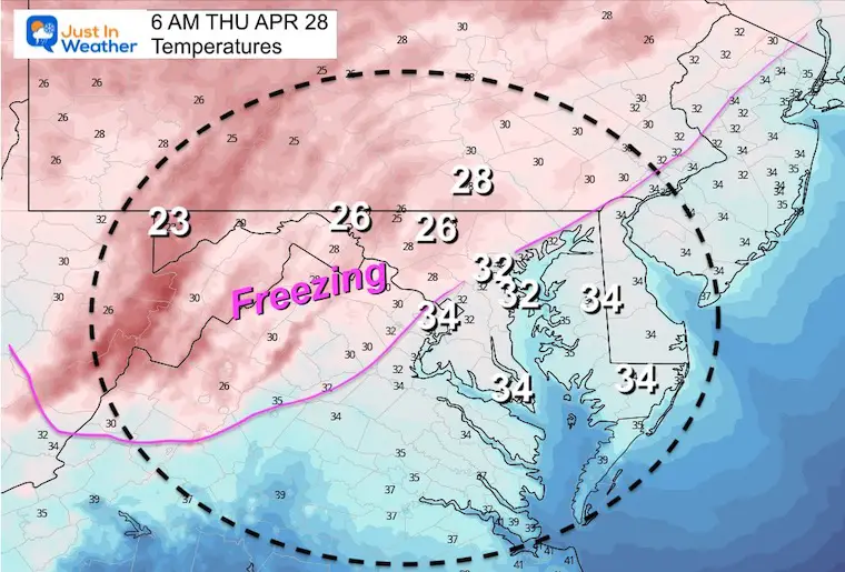

Widespread Frost or Freeze Thursday and Friday mornings. That’s a plant killer for sure.
This weekend we been a warm up, with top temps before thunderstorms on Monday afternoon.

Sign up and be the first to know!

Atlantic Tropical History: Maps of Origin Regions Every 10 Days


*Disclaimer due to frequent questions:
I am aware there are some spelling and grammar typos. I have made a few public statements over the years, but if you are new here you may have missed it:
I have dyslexia, and found out at my second year at Cornell. I didn’t stop me from getting my meteorology degree, and being first to get the AMS CBM in the Baltimore/Washington region.
I do miss my mistakes in my own proofreading. The autocorrect spell check on my computer sometimes does an injustice to make it worse.
All of the maps and information are accurate. The ‘wordy’ stuff can get sticky.
There is no editor that can check my work when I need it and have it ready to send out in a newsworthy timeline.
I accept this and perhaps proves what you read is really from me…
It’s part of my charm.