


July 5 Heating Up And Tropical Storm Chantal Expected To Get Named Today
Saturday, July 5 2025 Morning Report After the beautiful Independence Day we just had, we will see a little increase in heat and humidity today and tomorrow. There is a…
2 PM Sunday September 1
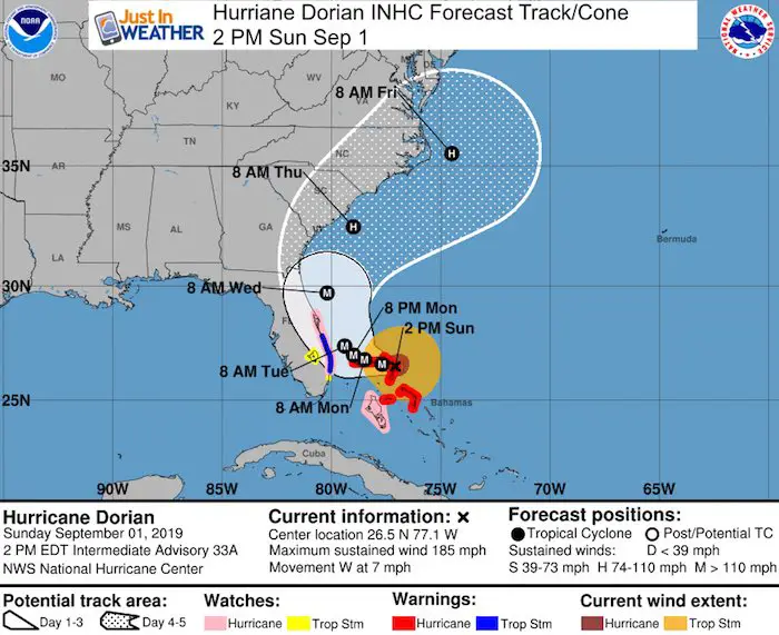
Hurricane Dorian has winds of 185 mph and is the strongest to hit The Bahamas on record. It’s happening right now! This ranks 2nd for top wind speed in the Atlantic. The record for top winds and deepest pressures in Atlantic history is below.
This will change the map, as has happened periodically throughout history. Some of Abaco Island and others in the north Bahamas will be reshaped or disappear from the wind, storm surge over 20 feet, flooding rain, and epic erosion. The curve to the north still shows it will stay off of the Florida coat but watches and warnings have been issued there.
Hurricane Dorian Infrared Satellite 2 PM
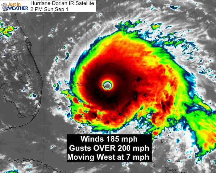
SUMMARY OF 200 PM EDT...1800 UTC...INFORMATION
----------------------------------------------
LOCATION...26.5N 77.1W
ABOUT 0 MI...0 KM OVER GREAT ABACO ISLAND
ABOUT 185 MI...295 KM E OF WEST PALM BEACH FLORIDA
MAXIMUM SUSTAINED WINDS...185 MPH...295 KM/H
PRESENT MOVEMENT...W OR 270 DEGREES AT 7 MPH...11 KM/H
MINIMUM CENTRAL PRESSURE...911 MB...26.90 INCHES
This now ranks tied with the 3rd fastest winds in the Atlantic Basin
But Hurricane Dorian is NOT in the Top 10 Lowest Pressure Yet
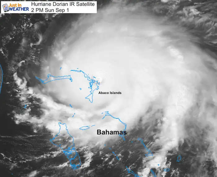
Hurricane Dorian Visible Satellite 2 PM
The eye was over Great Abaco Island at 2 PM
Hurricane Dorian Headlines
Hurricane Dorian Infrared Satellite Loop
The colder, higher cloud tops are colored in dark red and white.

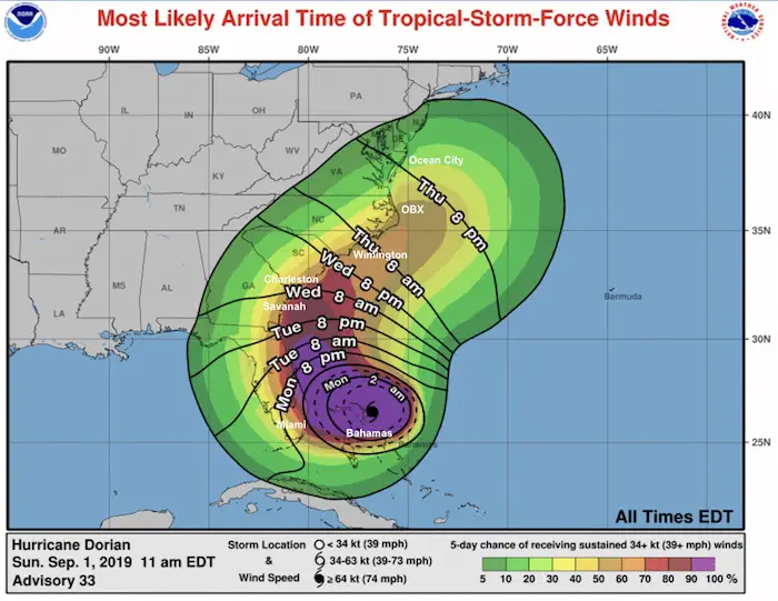
Tropical Storm Wind Arrival Forecast
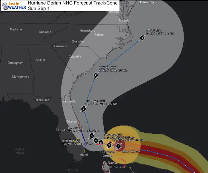
Florida gets it started Monday.
Ocean City Maryland may get it starting Thursday evening.
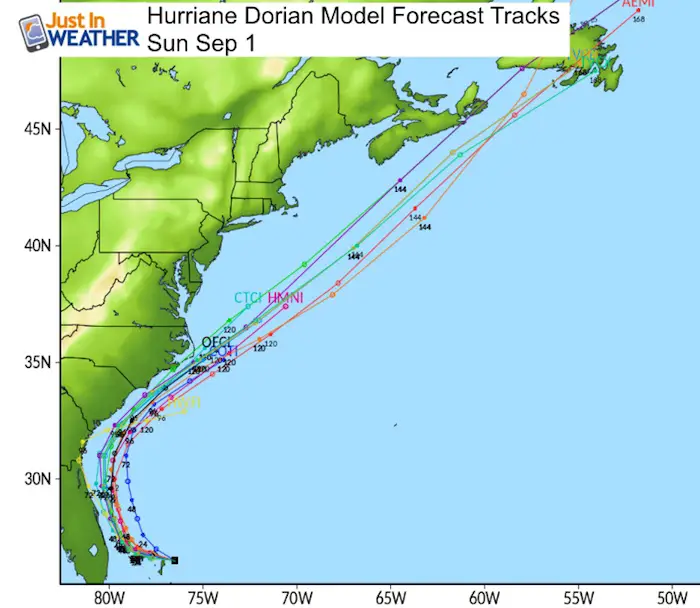
Forecast Tracks
Computer Model Spaghetti Plots
The consensus has this curving along but just off shore of the US East Coast through NC.
National Hurricane Center Forecast Track
Tropical Storm Warning and Hurricane Watch for parts of the Florida east coast.
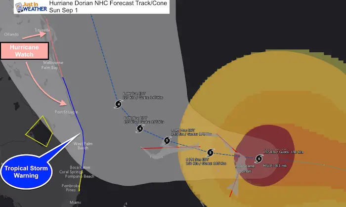
SUMMARY OF WATCHES AND WARNINGS IN EFFECT:

A Storm Surge Watch is in effect for...
* North of Deerfield Beach to the Volusia/Brevard County Line

A Hurricane Warning is in effect for...
* Northwestern Bahamas excluding Andros Island

A Hurricane Watch is in effect for...
* Andros Island
* North of Deerfield Beach to the Volusia/Brevard County Line

A Tropical Storm Warning is in effect for...
* North of Deerfield Beach to Sebastian Inlet

A Tropical Storm Watch is in effect for...
* North of Golden Beach to Deerfield Beach
* Lake Okeechobee

A Storm Surge Watch means there is a possibility of life-
threatening inundation, from rising water moving inland from the
coastline, in the indicated locations during the next 48 hours.
For a depiction of areas at risk, please see the National Weather
Service Storm Surge Watch/Warning Graphic, available at
hurricanes.gov.
Wider Track
European ECMWF Model Forecast
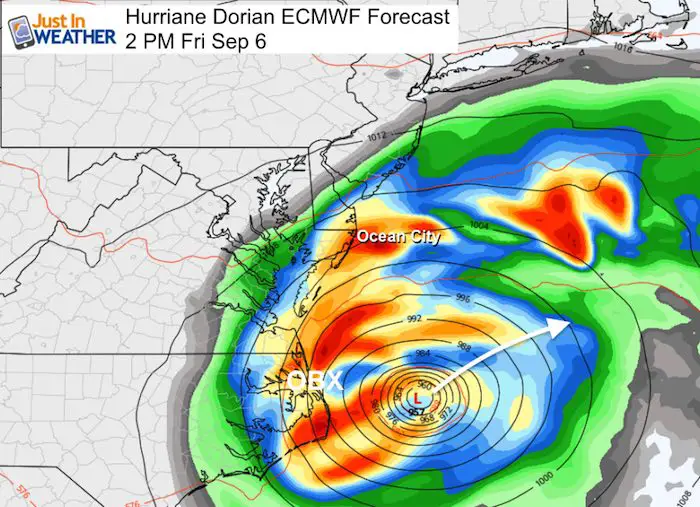
This keeps the eye offshore then clipping OBX North Carolina. Close enough for destructive waves, wind, and rainfall.. but the worst over remaining over the ocean.

Ocean City Maryland Impact?
As the storm exits the coast, the outer edge could still provide a few hours of heavy rain on top of some surge for Ocean City Maryland.
Forecast Thursday some rising water and storm surge may begin. Tropical Storm force winds are possible here, with the best chance for rain bands on Friday. The eye is expected to pass east by over 150 miles on Friday.
Official NHC Forecast Track/Cone Map
Just in case you don’t get all posts on your social media feed, stay up to date with the latest info…
Click here to sign up for email alerts…. Be the first to hear any new weather
Thank you to our Title Sponsor for Maryland Trek 6
Shining on with Smyth and their contribution, our team has raised over $95,000 for Just In Power Kids to provide free programs for kids in and post cancer treatment.

Please share your thoughts, best weather pics/video, or just keep in touch via social media
Maryland Trek Cycle Jerseys From Hill Killer
All proceeds will go to the Maryland Trek 6 total and Just In Power Kids programs

Just In Power Kids:
Proceeds go to our programs Providing FREE holistic care for kids in cancer treatment and up to 5 years post treatment and caregivers.
![]()
Shine On
Proceeds from all sales go to Just In Power Kids. Click the image to shop and show your support.

Love Maryland Shirts and Hoodies
This shirt was designed by my ‘bonus’ daughter Jaiden. The hoodie has been the biggest hit, so our promotion has been extended until the end of this week.
|
||
|
Show your love for Maryland and make this 14 year old artist and her mom extra proud
|
Related Links:
Was Your County Not Included?
Click this map for more on the regional forecast zones
