


July 12 Very Humid With Scattered Thunderstorms Later And More Storms Tomorrow
Saturday, July 12, 2025 Morning Report This may sound familiar: We remain in the ambiguous humid air mass. There is thick fog this morning, and the sun will dominate the…
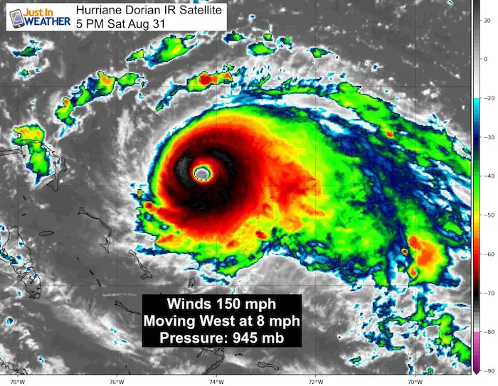
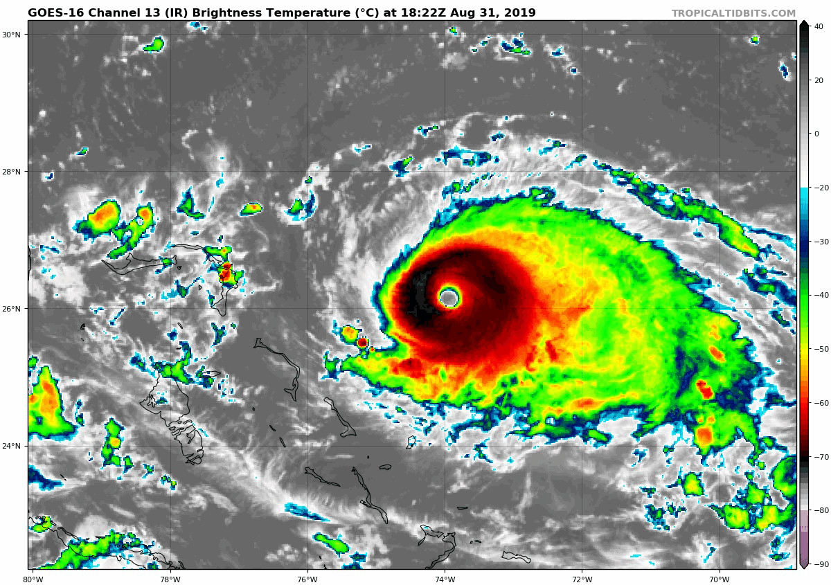
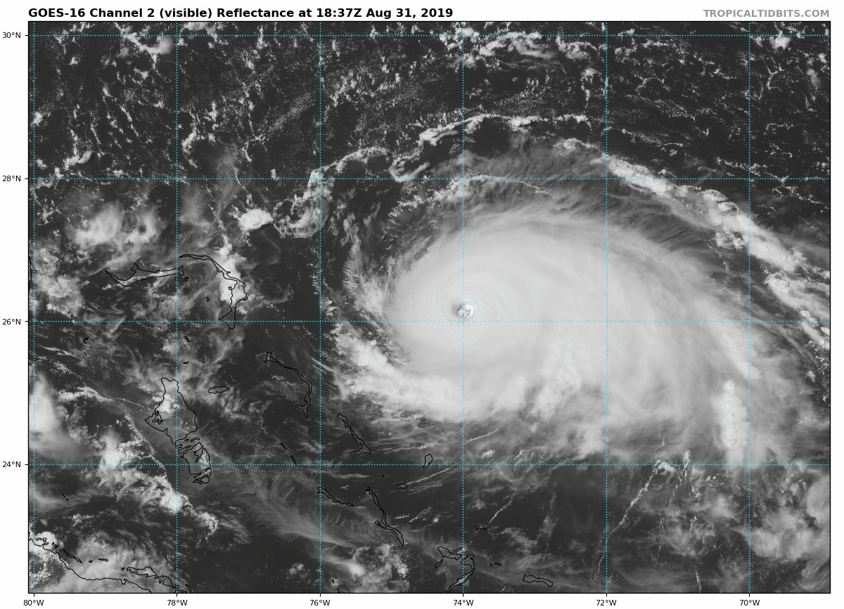
Saturday August 31 2019 at 5:45 PM
Hurricane Dorian remains on the upper edge of Category status with 150 mph winds. The structure looks as strong and healthy as possible as it moves to the west. The Bahamas are evacuating now. New Tropical Storm Watches are in place for parts of Florida. State of Emergency in place for South Carolina. But new forecast guidance has the storm turning north before the coast and heading closer to North Carolina.
Let’s start with a look at the satellite images. Loops for both the Infrared and Visible are below.
Hurricane Dorian Infrared Satellite at 5 PM
Hurricane Dorian Headlines
Hurricane Dorian Infrared Satellite Loop
The colder, higher cloud tops are colored in dark red and white.
Hurricane Dorian Visible Satellite at 5 PM
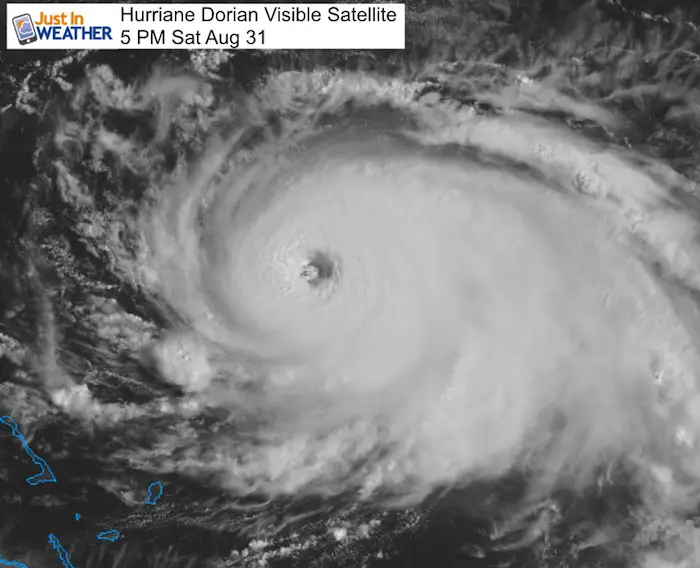
SUMMARY OF 500 PM EDT...2100 UTC...INFORMATION
----------------------------------------------
LOCATION...26.2N 74.4W
ABOUT 170 MI...270 KM E OF GREAT ABACO ISLAND
ABOUT 355 MI...570 KM E OF WEST PALM BEACH FLORIDA
MAXIMUM SUSTAINED WINDS...150 MPH...240 KM/H
PRESENT MOVEMENT...W OR 280 DEGREES AT 8 MPH...13 KM/H
MINIMUM CENTRAL PRESSURE...945 MB...27.91 INCHES
Hurricane Dorian Visible Satellite Loop
Forecast Maps
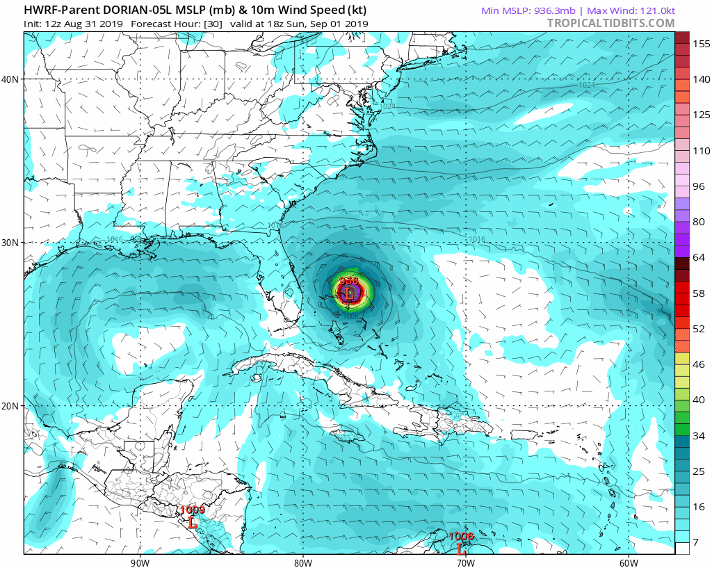
HWRF Model Animation
This model shows the turn to the north over the Bahamas, then heads toward the South Carolina coast and hugs it. This is farther west than the NHC and European which keeps to offshore from SC.
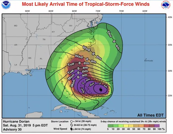
Wind Arrival Forecast
Due to the slow down and turn well east of Florida, the tropical storm force wind arrival times have changed. It looks like Monday morning for coastal Florida. Tuesday for north Florida and Georgia. Wednesday for South and North Carolina.
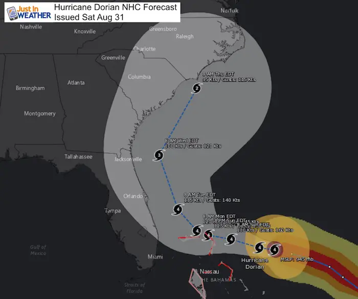
National Hurricane Center Forecast Tracks
The intensity will weaken due to cooler waters to the north. If this hits North Carolina, it is expected to be down to a Category 2. However, there is wave memory in the ocean for a few days, so the waves, surge, and rip currents will still behave like a stronger storm.
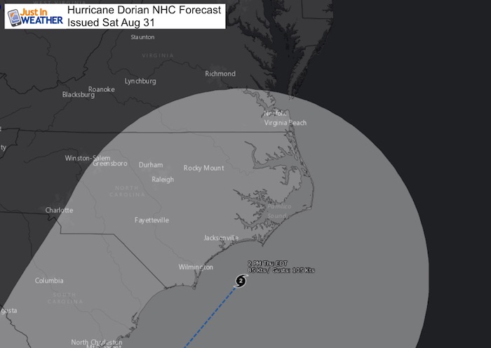
North Carolina Timing
While the Tropical Storm force winds will be moving in Wednesday. The eye of Dorian wil be passing by the coast Thursday afternoon and evening. These areas will be in storm mode for at least two days.
European ECMWF Model Forecast
This keeps the eye offshore from all of North Carolina. Close enough for destructive waves, wind, and rainfall.. but the worst over remaining over the ocean.
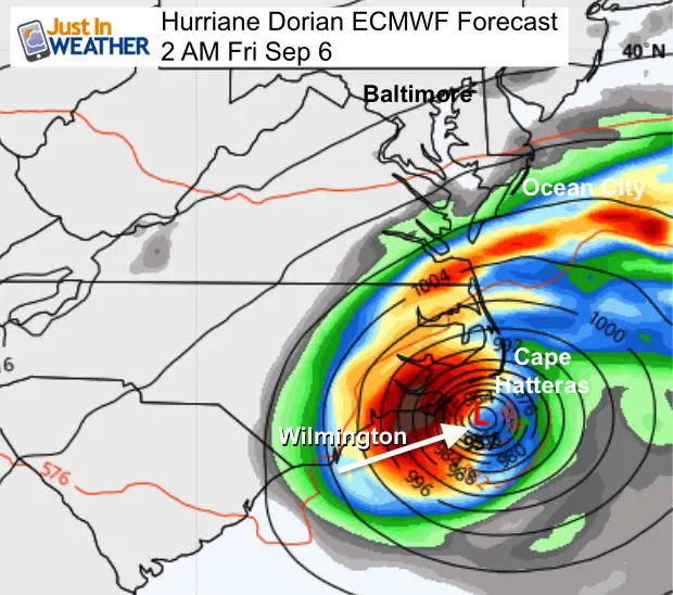
The National Hurricane Center has shifted their cone to match the European Model.
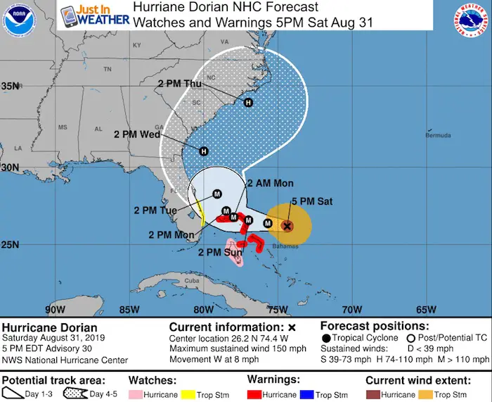
A Tropical Storm Watch has been issued for the east coast of Florida
from Deerfield Beach to Sebastian Inlet.

SUMMARY OF WATCHES AND WARNINGS IN EFFECT:

A Hurricane Warning is in effect for...
* Northwestern Bahamas excluding Andros Island

A Hurricane Watch is in effect for...
* Andros Island

A Tropical Storm Watch is in effect for...
* Deerfield Beach to Sebastian Inlet

A Hurricane Warning means that hurricane conditions are expected
somewhere within the warning area. Preparations to protect life and
property should be rushed to completion.

A Hurricane Watch means that hurricane conditions are possible
within the watch area.

A Tropical Storm Watch means that tropical storm conditions are
possible within the watch area, generally within 48 hours.
Just in case you don’t get all posts on your social media feed, stay up to date with the latest info…
Click here to sign up for email alerts…. Be the first to hear any new weather
Thank you to our Title Sponsor for Maryland Trek 6
Shining on with Smyth and their contribution, our team has raised over $95,000 for Just In Power Kids to provide free programs for kids in and post cancer treatment.

Please share your thoughts, best weather pics/video, or just keep in touch via social media
Maryland Trek Cycle Jerseys From Hill Killer
All proceeds will go to the Maryland Trek 6 total and Just In Power Kids programs

Just In Power Kids:
Proceeds go to our programs Providing FREE holistic care for kids in cancer treatment and up to 5 years post treatment and caregivers.
![]()
Shine On
Proceeds from all sales go to Just In Power Kids. Click the image to shop and show your support.

Love Maryland Shirts and Hoodies
This shirt was designed by my ‘bonus’ daughter Jaiden. The hoodie has been the biggest hit, so our promotion has been extended until the end of this week.
|
||
|
Show your love for Maryland and make this 14 year old artist and her mom extra proud
|
Related Links:
Was Your County Not Included?
Click this map for more on the regional forecast zones
