


Severe Thunderstorm Watch and Flood Watch Tuesday
Tuesday Afternoon Update July 1 2024 The atmosphere is juicy! Dew points are high in the mid to upper 70s, which means there is the potential for heavy rainfall and…
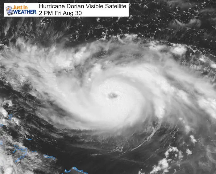
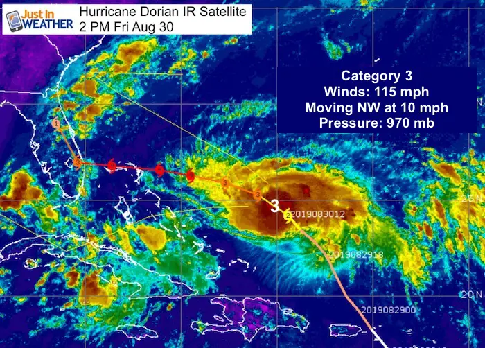
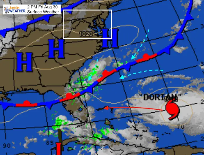
2 PM Friday August 30 2019
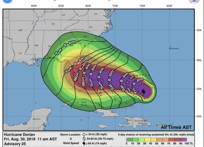
Hurricane Dorian has been upgraded to a Category 3. This is a major storm with winds of 115 mph and the eye looks even more healthy in the last few hours. The Hurricane Watch remains for the Bahamans, but not yet for Florida. That will be 48 hours ahead of expected hit. The entirety of Florida is under a State of Emergency.
Hurricane Dorian Visible Satellite
Here is the visible satellite form 2 PM and the eye looks more clear than this morning, indicating it will continue to strengthen and even grow larger. See the impressive loop below.
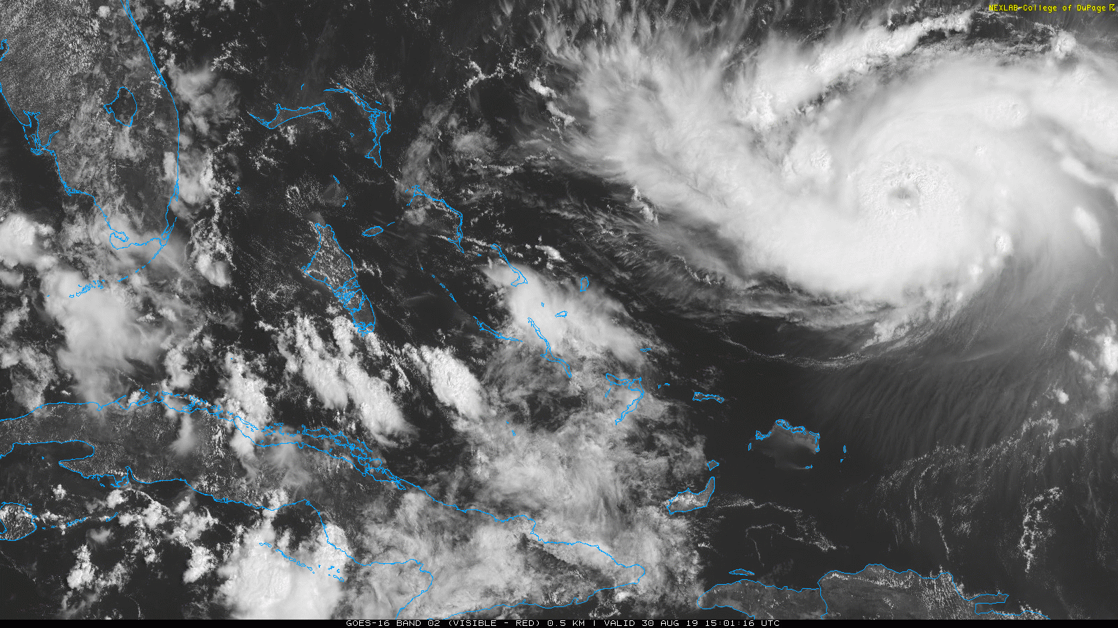
Hurricane Dorian Satellite Loop: How Close Is It?
At 2 PM:
2 PM Conditions
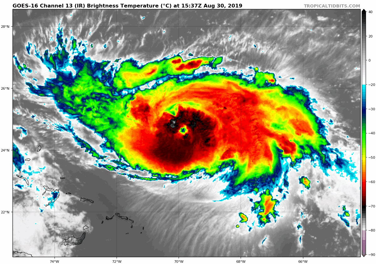
Infrared Satellite Loop
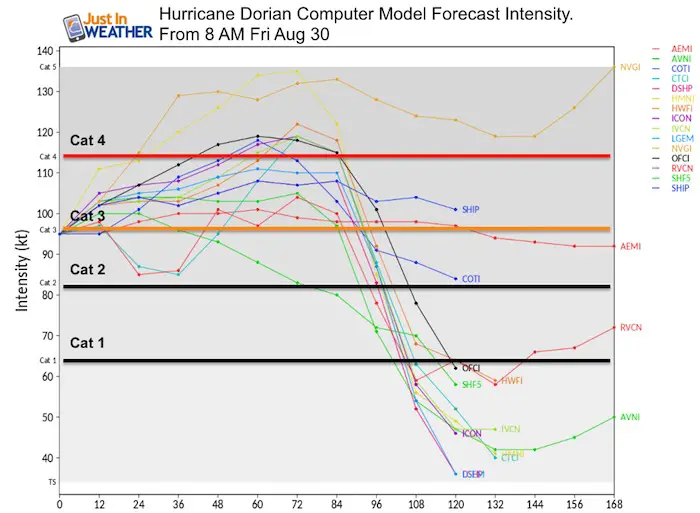
Forecast Models
The intensity of winds and category seen by the collection of models holds this at Category 3, but there is support for growth to Category 4 this weekend.
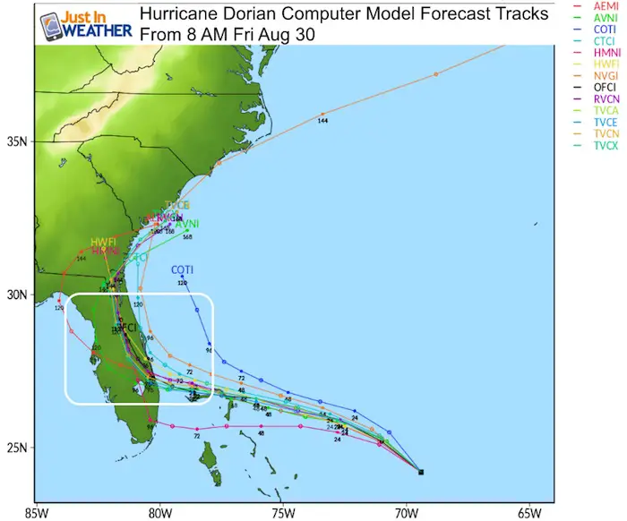
Forecast Tracks
Steering Currents
High Pressure and our old frontal boundary is helping to guide the upper level winds and move Dorian towards the west into Florida. Timing is key, as Dorian has shown signals of slowing its forward movement. That is why plotting out where it may be in 5 days in correlation to the systems to the north will determine if and when it curves back north.
Impact Earlier And Wider Than Landfall
Despite the forecast to hit land Monday night or Tuesday, the tropical storm force winds over 39 mph are likely on Sunday. A the storm grows larger, it will likely reach more than the current 105 miles in all directions.
Computer Model Agreement?
The GFS and European ECMWF Models are in more agreement on location, but still off by a few hours for landfall between Monday night and Tuesday morning. The frequent Air Force Reconnaissance Flights have increased our data and reliability.
These maps were based on the morning GFS and overnight Euro. The morning ECWMF model made the shift to turn north before landfall. I will have more on that this evening.

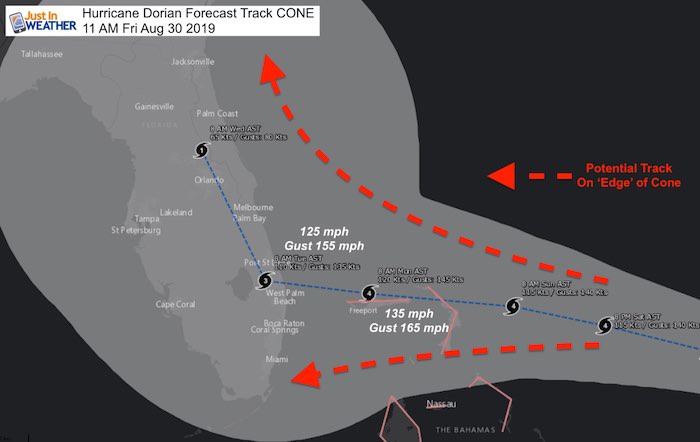
 Landfall Cone Of Uncertainty
Landfall Tracks spread out as the storm gets closer to the coast. This is to show the potential error in models and variation of influencing
forces. It is still possible for this to turn north or south and keeps all of Florida in play. The turn north is most likely, but that could happen
before landfall or once inland, to include a track over Orlando.
Note the wind forecast peaking Monday morning over Freeport, Bahamas at 135 mph gusting to 165mph+
Landfall Cone Of Uncertainty
Landfall Tracks spread out as the storm gets closer to the coast. This is to show the potential error in models and variation of influencing
forces. It is still possible for this to turn north or south and keeps all of Florida in play. The turn north is most likely, but that could happen
before landfall or once inland, to include a track over Orlando.
Note the wind forecast peaking Monday morning over Freeport, Bahamas at 135 mph gusting to 165mph+
National Hurricane Center Forecast Track
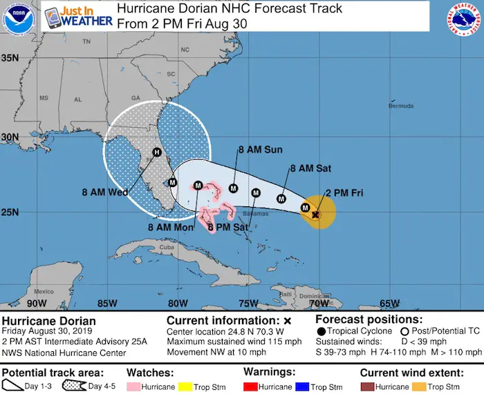
A Hurricane Watch is in effect for...
* Northwestern Bahamas

A Hurricane Watch means that hurricane conditions are possible
within the watch area.  A watch is typically issued 48 hours before
the anticipated first occurrence of tropical-storm-force winds,
conditions that make outside preparations difficult or dangerous.

Interests in southern and central Florida should monitor the
progress of Dorian.
Impact For Mid Atlantic?
Due to the uncertainty of this growing and slowing storm, I hesitate to speculate at this point. It impossible to have heavy rain in all or just
coastal portions next week. We could still be missed complete. This all depends on the timing of this in coordination with weather systems
heading our way.  Stay tuned as this will be in the news for the next week.
Just in case you don’t get all posts on your social media feed, stay up to date with the latest info…
Click here to sign up for email alerts…. Be the first to hear any new weather
Thank you to our Title Sponsor for Maryland Trek 6
Shining on with Smyth and their contribution, our team has raised over $95,000 for Just In Power Kids to provide free programs for kids in and post cancer treatment.

Please share your thoughts, best weather pics/video, or just keep in touch via social media
Maryland Trek Cycle Jerseys From Hill Killer
All proceeds will go to the Maryland Trek 6 total and Just In Power Kids programs

Just In Power Kids:
Proceeds go to our programs Providing FREE holistic care for kids in cancer treatment and up to 5 years post treatment and caregivers.
![]()
Shine On
Proceeds from all sales go to Just In Power Kids. Click the image to shop and show your support.

Love Maryland Shirts and Hoodies
This shirt was designed by my ‘bonus’ daughter Jaiden. The hoodie has been the biggest hit, so our promotion has been extended until the end of this week.
|
||
|
Show your love for Maryland and make this 14 year old artist and her mom extra proud
|
Related Links:
Was Your County Not Included?
Click this map for more on the regional forecast zones
