Winter Learning Center
Winter Precipitation
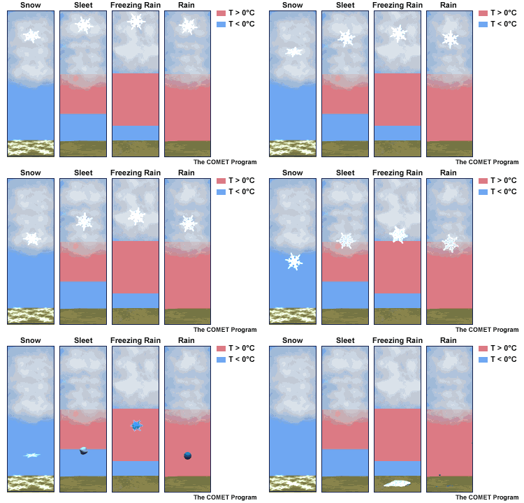
Winter precipitation can best be described as a variation of frozen ‘stuff’ falling from the clouds. But what that stuff is depends on the layers of cold and relatively warmer air. In the animation here, freezing is shown as 0°C, which is the same as 32°F. The blue layer is colder than freezing, while the red shading is above freezing. In some storm set ups, a layer of warmer air can be sandwiched between cold air above and below. Here is how that can affect the type of ‘stuff’ that falls.

Glossary
The process of snow laying and staying on the ground. There is no melting, just piling up to start the accumulation.
Snow seen on radar but sublimating and appearing to dry up before reaching the ground.
Snow skipping the melting and ice crystals going to gas form. It is not evaporation but rather sublimation.
Warm air can rise over a cold air mass. So the clouds can be warmer than the ground. Hills can be warmer than valleys too.
when the air temperature warms with height. It can be warmer on a hill top and colder in a valley. Same with a colder ground vs. warmer clouds.
Air moving in from one place to another
The cold air over the Great Lakes creating an unstable environment and heavy snow downwind. This usually stays close to the lakes and does not cross the mountains.
A fast moving storm originating in Alberta Canada that can drop a quick few inches of snow but often comes with very cold arctic air. This can also be a Saskatchewan Screamer.
A strong storm off of the East Coast of the US. This moves to the North East, into the Northeastern US, and the winds for coastal areas come around form … the Northeast. Thus, three reasons this type of storm gets its name.


