


Winter Weather
Lorem ipsum dolor sit amet, consectetur Dapsang elit. Suspensoids varius enim in eros elementum tristique. Duis cursus, mi quis viverra ornare, eros dolor interdum
Winter Weather History
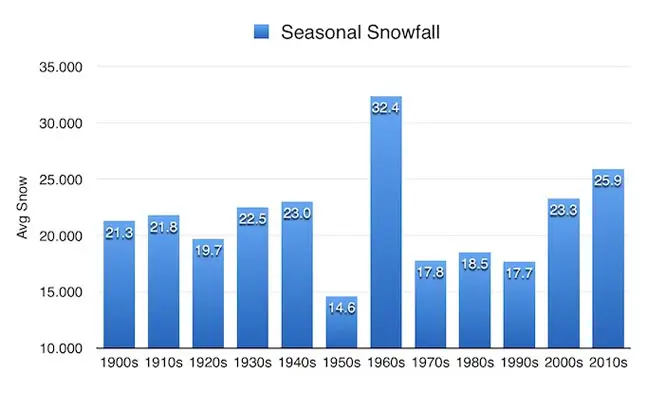
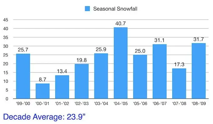
Maryland Snow
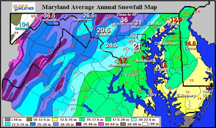
Maryland Average Annual Snowfall
Winter can be broken down into two main categories of weather. First is how much snow will fall, the other are the temperature. Snow in Maryland really highlights multiple climate zones across a small area. Elevation plays a big role as the mountains in western Maryland reach above 3,000 Ft and can catch Lake Effect (more like enhanced) Snow bands off of Lake Erie. An average winter will bring 104 inches to Deep Creek Lake, the home of Wisp , Maryland’s only ski resort. Just east, the mountains get lower and can experience a rain shadow effect where the air dries out from downslope winds. Various ridges and valleys can make for a dramatic difference in snowfall. See the map below of for the drop from and average of 36.5″ of snow in Cumberland to 26.5″ in Hagerstown. The mountains in between get a lot more. Frederick city is at the base of the Catoctin Mountain Range and averages 20.5″ of snow a year. But the northern part of the county, only 20 miles away in the mountains, can get close to 40 inches. Baltimore and the suburbs have an equally dramatic change higher and lower just based on topography and The Chesapeake Bay.
Maryland Topography
Generally flat, influenced by the Atlantic Ocean and Chesapeake Bay water keeping it warmer than freezing in most events.
Marked very close to I-95.Some rolling hills, but still influenced by Chesapeake Bay warmer water.
Rolling hills, increase in elevation close to 1000 Ft above sea level. This includes the Hereford Zone in northern Baltimore County, but that ridge extends to northern Harford, much of Carroll, and western Howard Counties. The higher elevation and distance away from the water can often be cool enough to allow more snow to fall and stick.
This is broad valley between Frederick and Mount Airy. Temperatures can be warmer at lower elevations and trap cold air near the surface in some winter storms while warmer air is pushed above mountains. This is a prime target for sleet and freezing rain = ice storms. Blue Ridge Province = Catoctin Ridge. Mountains reach up to around 1,500 Ft.
Great Valley Section, Folded Appalachian, and Allegheny Mountain Section. This region has steep mountains and valleys. The elevation reaches above 3,000 Ft in far western Maryland- Garrett County. This can catch Lake Effect Snow from Lake Erie in addition to larger coastal storms.
'North and West' Gets More
A truly dramatic showing of snow variation is around Baltimore. To the northwest, the elevation rises from near sea level to 1,000 feet in parts of arrow County and northern Baltimore County in the Hereford Zone. These places average over 30 inches of snow, or at least 50% more than BWI. Some places near the Pennsylvania line can get close to 40 inches of snow (almost double that of BWI) in a typical winter. But on the east side, the low level and proximity to the Chesapeake Bay keep temps just warm enough to often change snow to rain and curt down on accumulation in many events. East coast storms bring in winds and moisture off of the warmer water. Until the northern Bay freezes, it can be a source of heat. But the rise in elevation is why the Northwest suburbs can average more snow than some of the higher mountain areas to the west.
I-95 is a separation of snow vs. rain for many storms: The warmer conditions and more rain tend to fall east of I-95, where the elevation is around sea level and warming from the Chesapeake Bay is just enough to stay above freezing.
When a storm arrives from the west, it will often dump snow or rain on the mountains, but dry up in the valleys and lower elevations farther east. That is why they can appear to break up or fall apart sometimes.
Eastern Shore and Southern Maryland
With areas near sea level, warmer winds can play an easier influence within storms. That is why this area gets a lot less. But notice the lowest amount are places closest to the water. Interior Delmarva can escape this and get a little more in a typical winter.
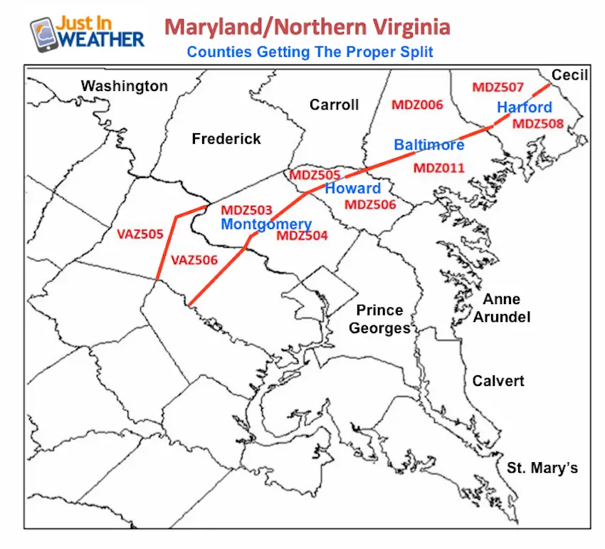
New Split NWS Weather Zones
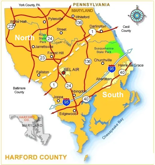
Closer Look at Zones Around Metro Baltimore
The cut off is north of Bel Air. Fallston and Forest Hill tend to be just high enough in elevation and far enough away from the Chesapeake Bay to stay colder and keep snow around longer.
The cut off is north of Bel Air. Fallston and Forest Hill tend to be just high enough in elevation and far enough away from the Chesapeake Bay to stay colder and keep snow around longer.
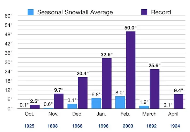
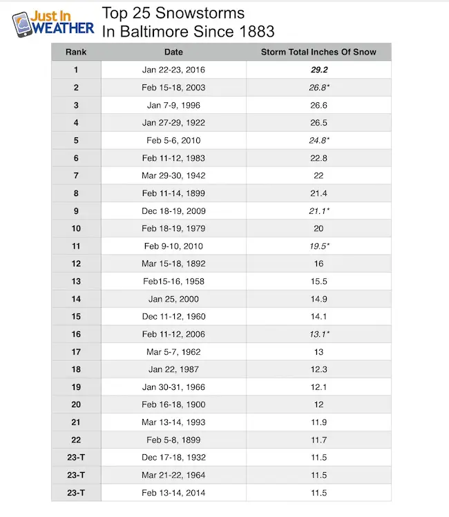
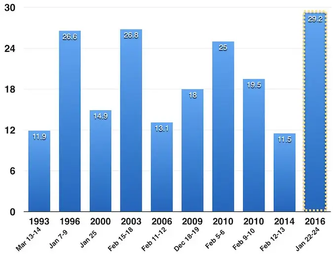
Baltimore Snowfall Charts
Winter Learning Center
Winter Precipitation
Winter precipitation can best be described as a variation of frozen ‘stuff’ falling from the clouds. But what that stuff is depends on the layers of cold and relatively warmer air. In the animation here, freezing is shown as 0°C, which is the same as 32°F. The blue layer is colder than freezing, while the red shading is above freezing. In some storm set ups, I can sandwich a layer of warmer air between cold air above and below. Here is how that can affect the type of ‘stuff’ that falls.
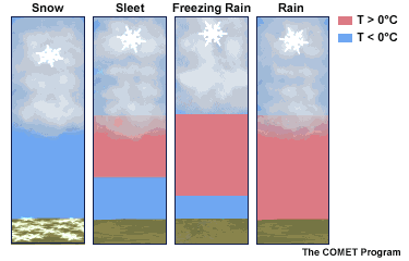

Below freezing in the clouds and on the way down. *It can snow when the surface air is warmer, but colder snowflakes don’t melt yet.

A thin inversion melts snow or starts out as rain, then it refreezes on the way down to the ground. This ‘pings’ when it hits and can hurt. The layer of cold air near the ground is thick.

A thicker inversion melts snowflakes or starts as rain. The thin layer of freezing air near the ground i snot enough to refreeze the precipitation. It will fall as rain, but freeze on contact with the surface.

Warm enough above freezing to the ground.
Glossary
The process of snow laying and staying on the ground. There is no melting, just piling up to start the accumulation.
Snow seen on radar but sublimating and appearing to dry up before reaching the ground.
Snow skipping the melting and ice crystals going to gas form. It is not evaporation but rather sublimation.
Warm air can rise over a cold air mass. So the clouds can be warmer than the ground. Hills can be warmer than valleys too.
when the air temperature warms with height. It can be warmer on a hill top and colder in a valley. Same with a colder ground vs. warmer clouds.
Air moving in from one place to another
The cold air over the Great Lakes creating an unstable environment and heavy snow downwind. This usually stays close to the lakes and does not cross the mountains.
A fast moving storm originating in Alberta Canada that can drop a quick few inches of snow but often comes with very cold arctic air. This can also be a Saskatchewan Screamer.
A strong storm off of the East Coast of the US. This moves to the North East, into the Northeastern US, and the winds for coastal areas come around form … the Northeast. Thus, three reasons this type of storm gets its name.