


December 3 Cold Icy Start To A Dry Day With Next Snow Chance Friday
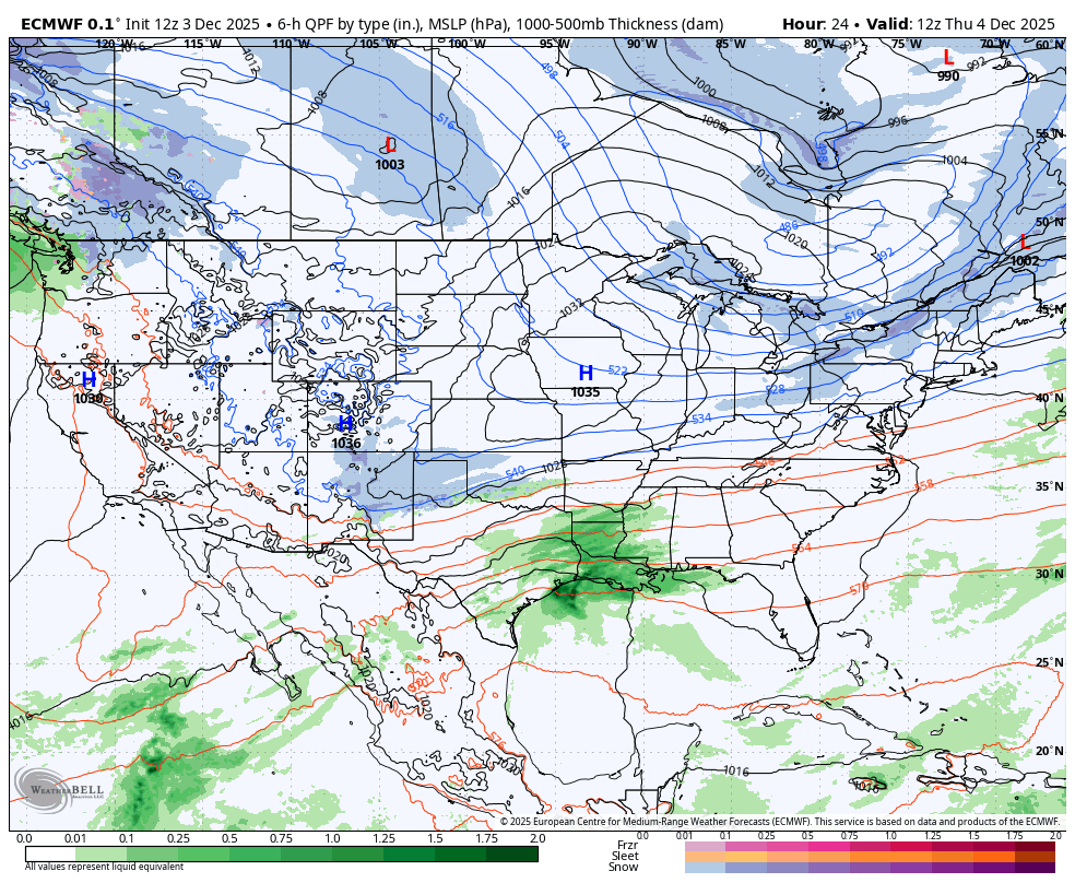
Wednesday, December 3 2025 Morning Report This morning starts off cold and dry, but after the heaviest rainfall in months, it could be a little icy. Widespread temps in the…
Wednesday December 3
Evening Update
A little bit of snow can be a big problem, essentially when the thing is for a commute and the temperatures will be cold enough to stick.
I have heard other parts of the country were laughing at Maryland for closing schools when it rained. After nearly 30 years in this region, I still feel the need to emphasize how much weather conditions can change over a short drive within the same county.
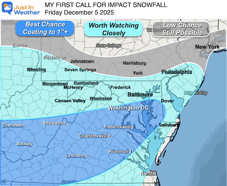
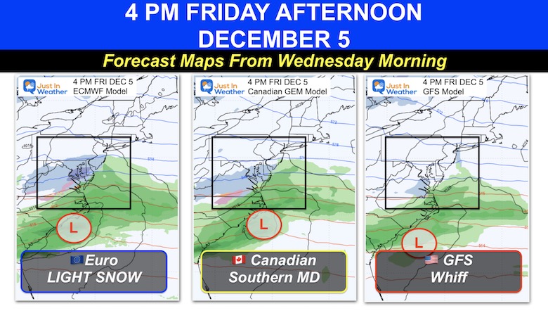
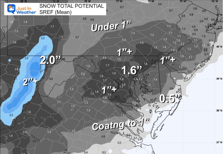
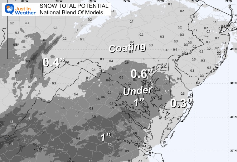
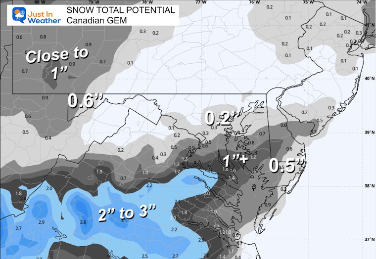
The little weather event on the way is going more support to impact the afternoon drive home into Central Maryland, but not 100% agreement. Which is important will be the spread of steady snow for many hours. This range of snow will generally be a coating to 1 inch, which the high end to 2 inches.
Do you remember how special December 5th for snow? It was the first day for Baltimore almost every year for a decade. It is also the day in 2009 that began Faith in the Flakes with my son. See that story here
The collection of computer models I scan are not in agreement, but I see the trend to push the emphasis into Central Maryland which is why I highlighted metro Baltimore as an area Worth Watching.
The higher chance will be south, and less north…. But there are subtle features the models are just picking up on.
This is for areas may get impacted by a coating or more. Please see my notes AND compare MANY MODEL SNOW TOTAL MAPS below.
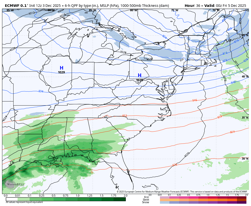
Here is my reasoning, starting with the wide view first:
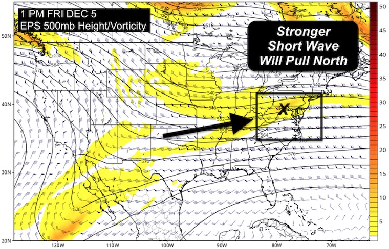
Here is the EPS, Ensemble Prediction Model. This is a blend of models to give better likelihood.
I will be watching for the energy showing up as this short wave in the Southern Rockies. Each run has been growing more amplified, meaning a little stronger.
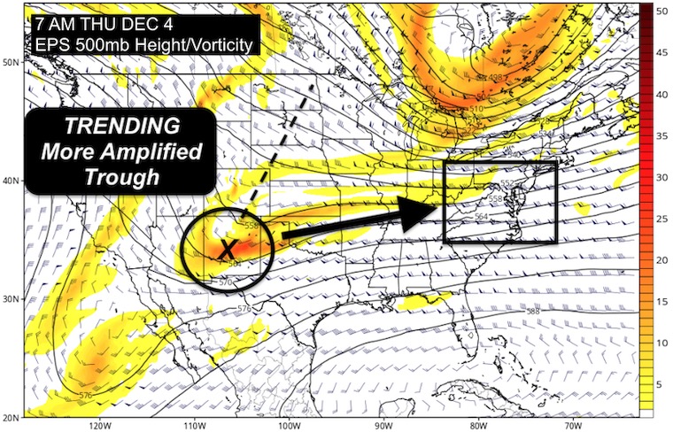
That short wave will be entering the Mid Atlantic. The jet stream is relative zonal, meaning this will be a quick event and not a lot of moisture. But it has the potential to produce a few hours of steady snow.
Animation 7 AM Thursday to 7 PM Friday
This has been the most aggressive to develop a band of light snow and bring it through most of Maryland and clipping Southern Pennsylvania.
Thursday Night To Saturday Morning
The expansion of light snow into Central Maryland would be focused to arrive close to noon and last into the evening. This will be gone by Saturday morning.
Here is the look at the American Model
Left: NEWER Run pushing the snow farther north into metro Baltimore.
Right: The OLDER morning run that had the light snow into Southern Maryland and very little impact.
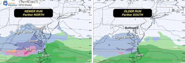
I am showing you these simply to compare and contras. Also to see which may do the bet job when we do a post analysis.
List From Highest/Farthest North to Weakest
This was based off the morning weaker and southern track
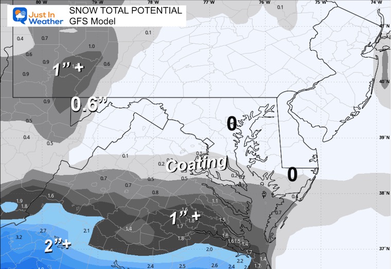
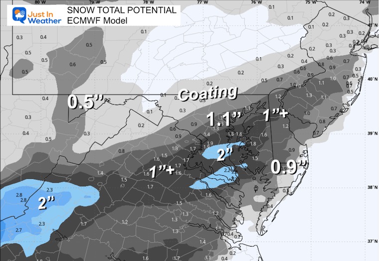
This is my conservative approach that I showed my clients for best impact odds. This is really more about where there will be impact rather than how much. We are still looking between a coating and 1 inch. The highest end will be up to 2 inches.

Subscribe for eMail Alerts
Sign up and be the first to know!
Click here for the full report

This was issued October 9, as expected: A weak and short-lived event to start winter may play a different role this winter.

These are NOT all the same caterpillar!


Click to see more and ‘Book’ a visit to your school


The annual event: Hiking and biking 329 miles in 7 days between The Summit of Wisp to Ocean City.
Each day, we honor a kid and their family’s cancer journey.
Fundraising is for Just In Power Kids: Funding Free Holistic Programs. I never have and never will take a penny. It is all for our nonprofit to operate.
Click here or the image to donate:

I am aware there are some spelling and grammar typos and occasional other glitches. I take responsibility for my mistakes and even the computer glitches I may miss. I have made a few public statements over the years, but if you are new here, you may have missed it: I have dyslexia and found out during my second year at Cornell University. It didn’t stop me from getting my meteorology degree and being the first to get the AMS CBM in the Baltimore/Washington region. One of my professors told me that I had made it that far without knowing and to not let it be a crutch going forward. That was Mark Wysocki, and he was absolutely correct! I do miss my mistakes in my own proofreading. The autocorrect spell check on my computer sometimes does an injustice to make it worse. I can also make mistakes in forecasting. No one is perfect at predicting the future. All of the maps and information are accurate. The ‘wordy’ stuff can get sticky. There has been no editor who can check my work while writing and to have it ready to send out in a newsworthy timeline. Barbara Werner is a member of the web team that helps me maintain this site. She has taken it upon herself to edit typos when she is available. That could be AFTER you read this. I accept this and perhaps proves what you read is really from me… It’s part of my charm. #FITF