February 8 2025
Saturday Morning Report
This weather event today is arriving earlier and tapping into colder air. This has produced snow sooner in Southern Maryland at daybreak and may help to lock in the cold air longer.
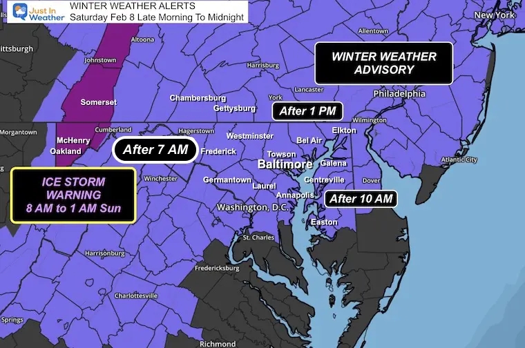
This snow may push up to 1 inch and then change to sleet and freezing rain.
I have had to adjust my best guess for the impact. This includes where the ground is warmer and the timing with daylight. IMPORTANT: This forecast is NOT perfect! It is a guide because conditions on the pavement may change from one side of town to another and then cross to other towns. Please be very alert for any changes.
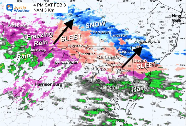
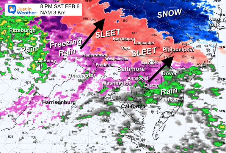
The biggest impact will be during the afternoon through tonight near and north of Baltimore, as the weather advances from the south.
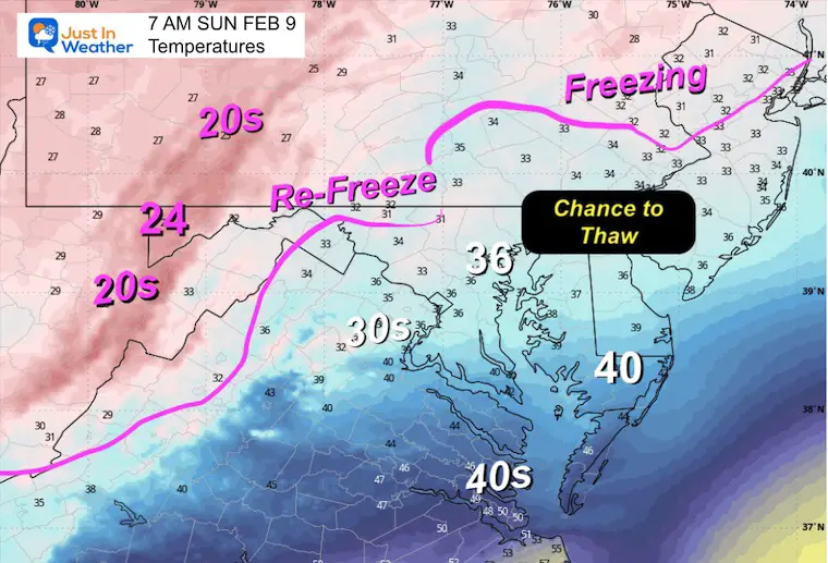
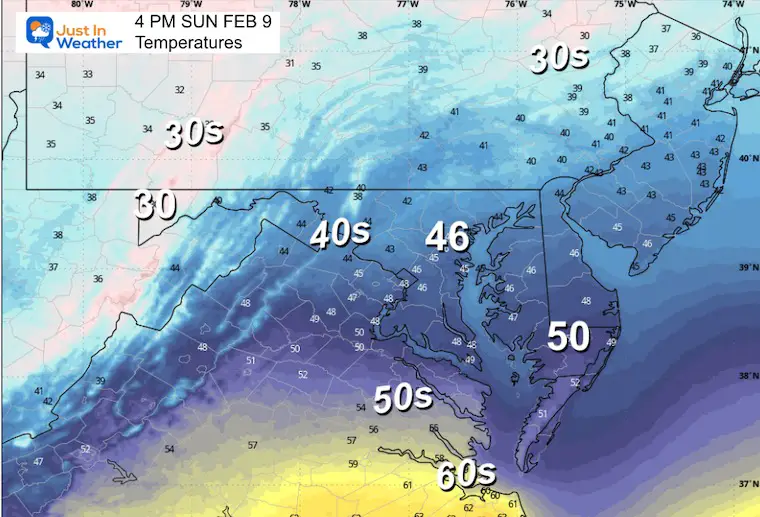
This will end overnight with a thaw Sunday and plenty of time to dry out and head to Super Bowl Parties.
The next system looks to be snow on Tuesday and could end up being an all-day event… Then, the likelihood of more systems will continue, but the timing and track get fuzzy. Just plan for an active two weeks or more ahead.
DROUGHT UPDATE
Rainfall Deficit at BWI
Ending 2024 = -8.00″, since Jan 1 = -1.77
So we are down -9.77″ including last year!
CLIMATE DATA: Baltimore
TODAY February 8
Sunrise at 7:06 AM
Sunset at 5:36 PM
Normal Low in Baltimore: 26ºF
Record -1ºF in 1967
Normal High in Baltimore: 45ºF
Record 72ºF 2017
Baltimore Seasonal Snow
8.9”
Winter Weather Alerts
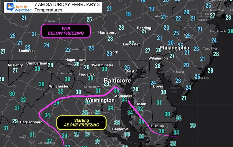
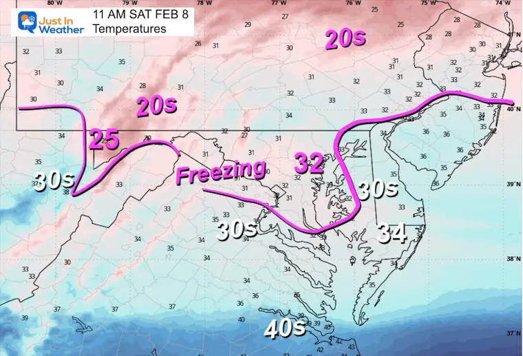
Morning Temperatures
This is part of the challenge. It is snowing in places that are above freezing. Temps should chill a little, but daylight AND warm roads may battle stickage. Farther north, the cold should hold and lock in longer.
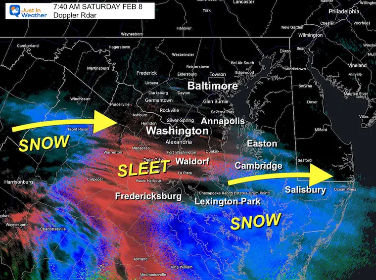
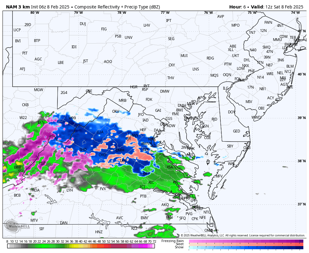
Doppler Radar Snapshot
The snow and sleet have arrived early in Southern Maryland. However, the temperatures shown above are above freezing. This will be a challenge. The pavement there is warm, and the temperatures may still drop a few degrees. So, a few hours this morning may be worth watching for icy spots, but mid-day roads should be wet.
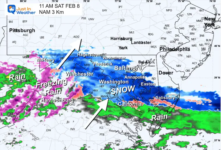
Further north, the snow and sleet will reach Washington and Annapolis before 10 AM and pass metro Baltimore before noon—just an hour or two earlier than I expected last night.
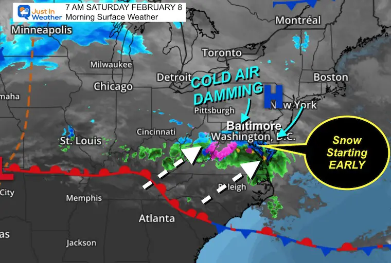
Morning Surface Weather
This system is developing and moving in a little faster than expected. This may lock in the cold air for more places resulting in a sooner impact on the roads.
UPDATE from NOON
SLOW AND GRADUAL DEVELOPMENT This Afternoon
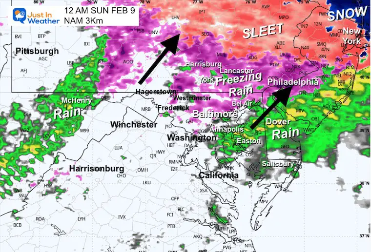
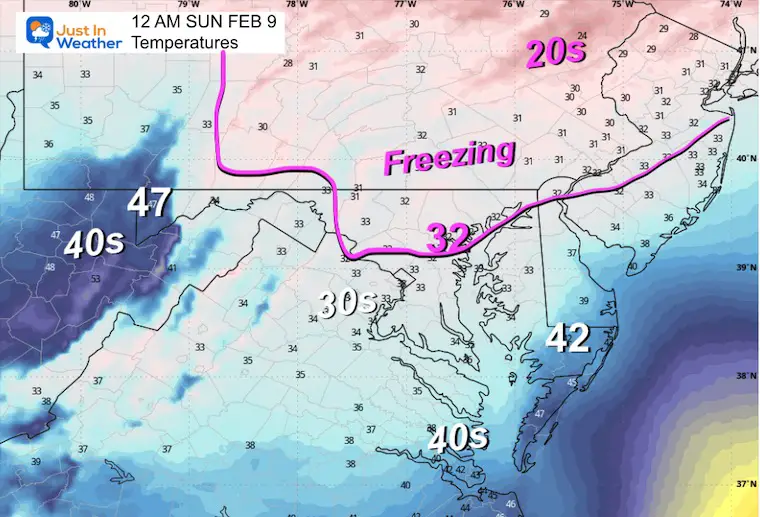
Radar Simulation 8 AM Sat to 2 AM Sun
My Updated Call For Ice Impact On Roads
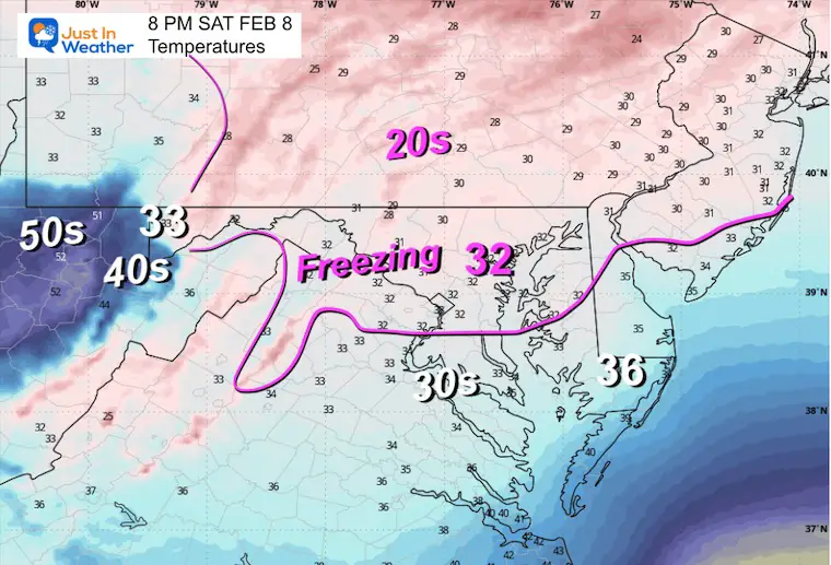
Saturday Weather: Snapshot Highlights
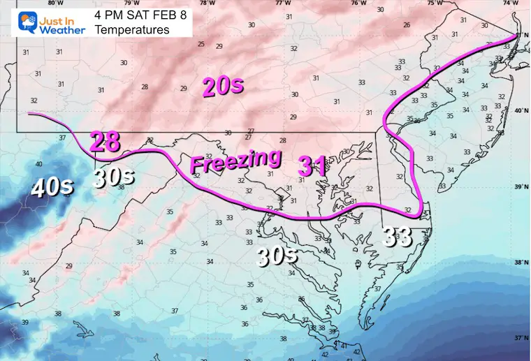
Radar Simulation and Temperatures
11 AM
4 PM
8 PM
Midnight
Repeating:
My Updated Call For Ice Impact On Roads
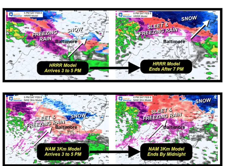
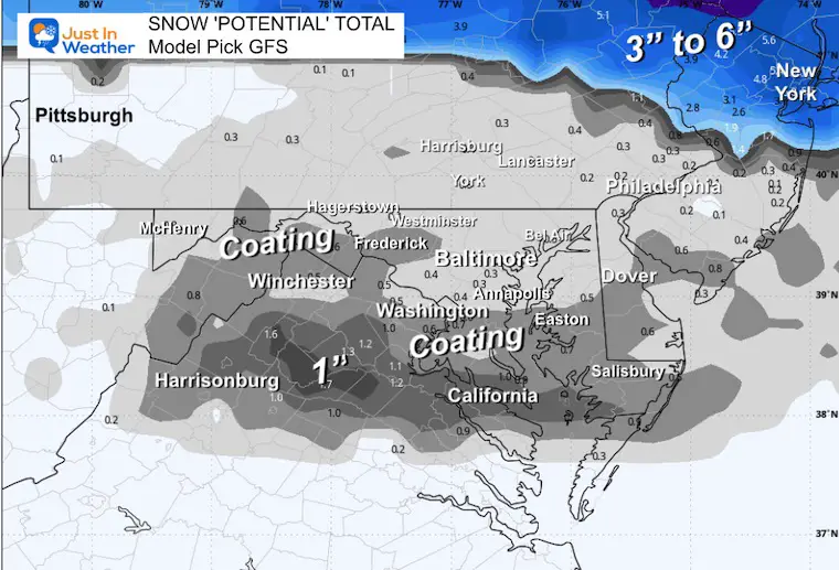
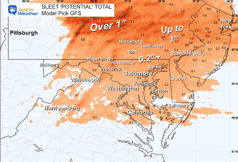
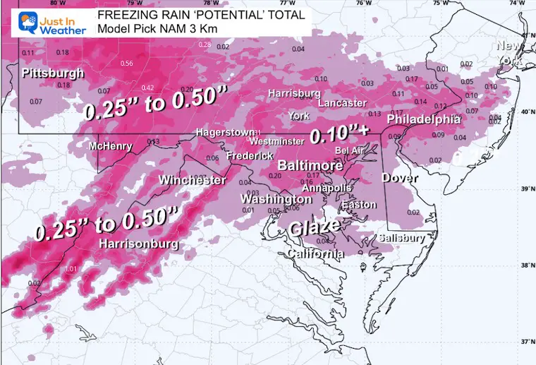
Winter Precipitation POTENTIAL Forecasts
I looked at a bunch of models and used my best guess at which is handling each type of precipitation better. Some are overdoing the snow and freezing rain. Here are my picks at which is doing the best and should end up closest to what we actually see.
GFS Snow
NAM 3Km Sleet
GFS Freezing Rain
Sunday Weather
Morning Temperatures
Afternoon Temperatures
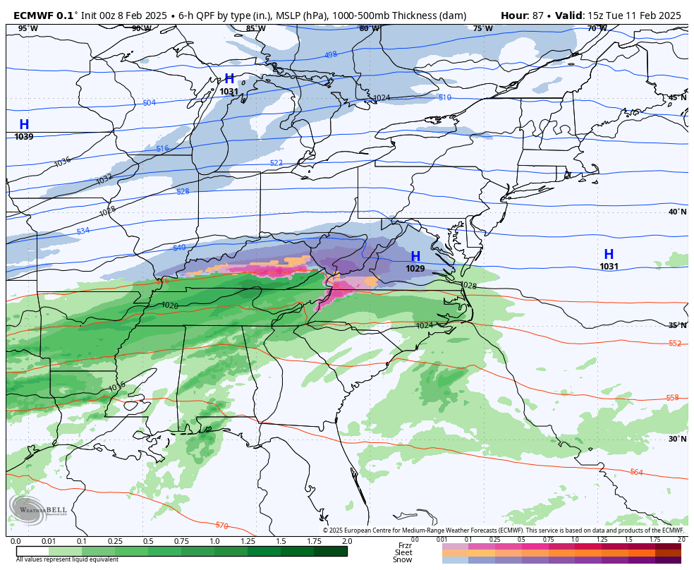
Tuesday Snow To Thursday Mix
Forecast Animation ECMWF Model
7 AM Tue to 7 AM Thu
The European Model here shows the active pattern that may blend one storm into the next.
Here we see the burst of snow on Tuesday, a light icy mix on Wednesday, and then a mix to rain on Thursday.
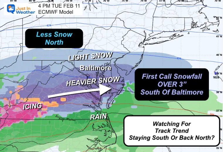
Afternoon at 4 PM
The ECMWF highlights the burst of moderate snow to include Central AND Southern Maryland.
This first call for snow totals: My suggestion is for over 3 inches near and south of Baltimore, less to the north. That is to help with the idea that there will be enough to shovel or plow.
The trend shifted a little south in the last run, but I am watching for a possible bump back north that could affect where the bulk of this may fall.
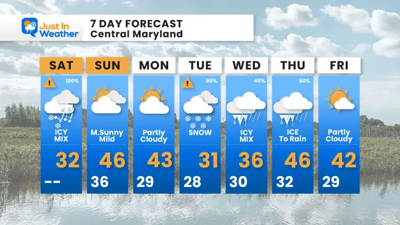
7 Day Forecast
After today, we thaw.
The next event will be more snow on Tuesday.
Midweek is questionable as the active pattern will be spreading a few systems our way, and the arctic air will be measuring… possibly lifting north to end with rain.
There is more in the pipeline.
Subscribe for eMail Alerts
La Nina Advisory January 2025
Full Report

MY WINTER OUTLOOK
My Winter Outlook Report

ALSO SEE
Recent Snow Reports
SNOW REPORTS THIS SEASON
Click on the maps for that full report.
January 19 Snow Report

January 11 Snow Report

January 6 Snow Report

Previous Snow

FITF Gear on Sale

In Case You Missed This
The Faith In The Flakes Dec 5 Origin Story

Please share your thoughts and best weather pics/videos, or just keep in touch via social media.
SCHEDULE A WEATHER BASED STEM ASSEMBLY
Severe Weather: Storm Smart October and next spring Winter Weather FITF (Faith in the Flakes): November To March Click to see more and send a request for your school.

THANK YOU:
Baltimore Magazine Readers Choice Best Of Baltimore
Maryland Trek 11 Day 7 Completed Sat August 10
We raised OVER $104,000 for Just In Power Kids – AND Still Collecting More
The annual event: Hiking and biking 329 miles in 7 days between The Summit of Wisp to Ocean City.
Each day, we honor a kid and their family’s cancer journey.
Fundraising is for Just In Power Kids: Funding Free Holistic Programs. I never have and never will take a penny. It is all for our nonprofit to operate.
Click here or the image to donate:

RESTATING MY MESSAGE ABOUT DYSLEXIA
I am aware there are some spelling and grammar typos and occasional other glitches. I take responsibility for my mistakes and even the computer glitches I may miss. I have made a few public statements over the years, but if you are new here, you may have missed it: I have dyslexia and found out during my second year at Cornell University. It didn’t stop me from getting my meteorology degree and being the first to get the AMS CBM in the Baltimore/Washington region. One of my professors told me that I had made it that far without knowing and to not let it be a crutch going forward. That was Mark Wysocki, and he was absolutely correct! I do miss my mistakes in my own proofreading. The autocorrect spell check on my computer sometimes does an injustice to make it worse. I also can make mistakes in forecasting. No one is perfect at predicting the future. All of the maps and information are accurate. The ‘wordy’ stuff can get sticky. There has been no editor who can check my work while writing and to have it ready to send out in a newsworthy timeline. Barbara Werner is a member of the web team that helps me maintain this site. She has taken it upon herself to edit typos when she is available. That could be AFTER you read this. I accept this and perhaps proves what you read is really from me… It’s part of my charm. #FITF


