


July 5 Heating Up And Tropical Storm Chantal Expected To Get Named Today
Saturday, July 5 2025 Morning Report After the beautiful Independence Day we just had, we will see a little increase in heat and humidity today and tomorrow. There is a…
Friday Night Update February 7, 2025
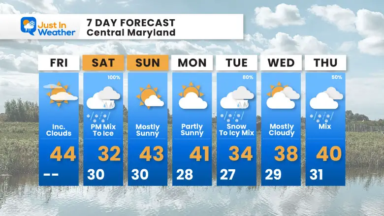
The Winter Weather Advisory for our next ice event has already been expanded to include more of Maryland. This may look similar to the Thursday morning event with the impact areas and event totals, but the timing will be different, and it presents more challenges.
Saturday may bring light snow or sleet before mid day as this arrives, then turn to more sleet and eventually freezing rain through the day and evening.
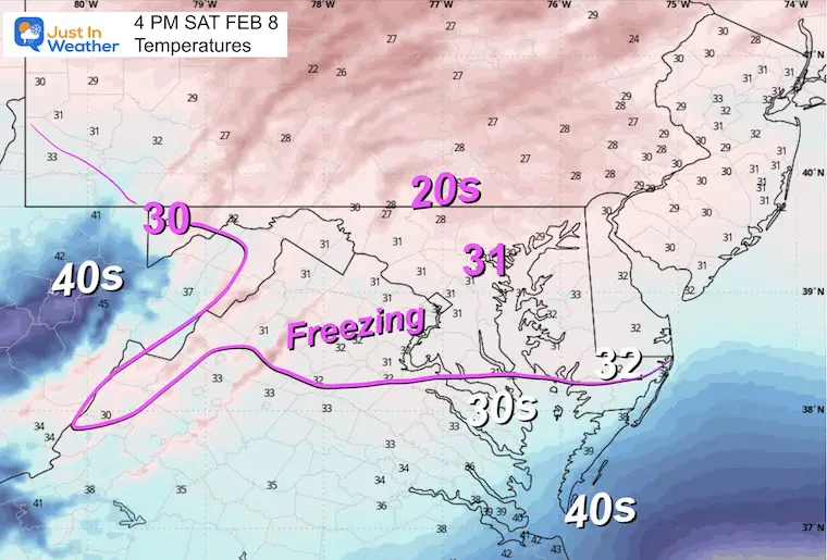
My concern will be later in the day for most areas. The midday hours may see most areas with wet roads, but as the sun angle gets lower through the evening, the road temperatures will cool enough for more icing. So, instead of the past overnight event, this may catch you during the travels.
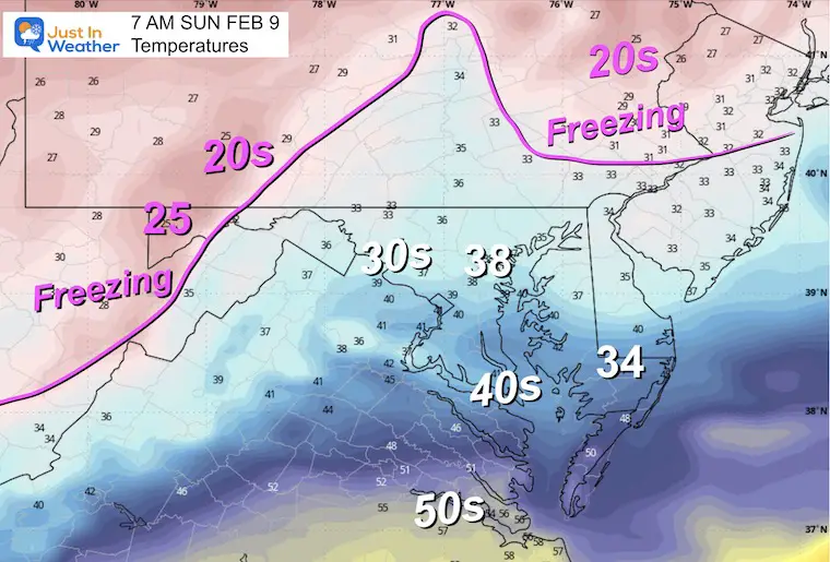
The good news is that we may stay above freezing in most areas to allow for a thaw into Sunday morning.
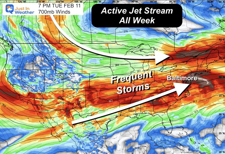
I will show my map of suggestions followed by the forecast details. Then the next storm will be colder and allow for more snow Tuesday afternoon.
The Winter Weather Advisory now covers most of the same areas that were affected on Thursday morning. The start time is based on the arrival mid-morning in Maryland and early afternoon in Southern Pennsylvania.
Ice Storm Warning AGAIN for the high mountains. This also affects the ski areas of Wisp and Seven Springs.
Note: These are issued by The National Weather Service local offices for each region.
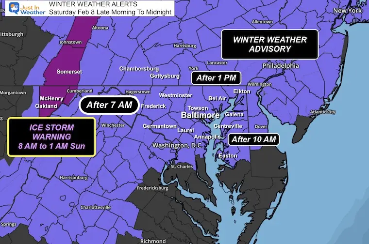
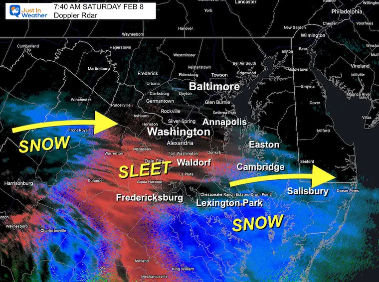
The snow arrived EARLIER in Southern Maryland. Click here or this map for the NEWEST Information and UPDATED MAPS
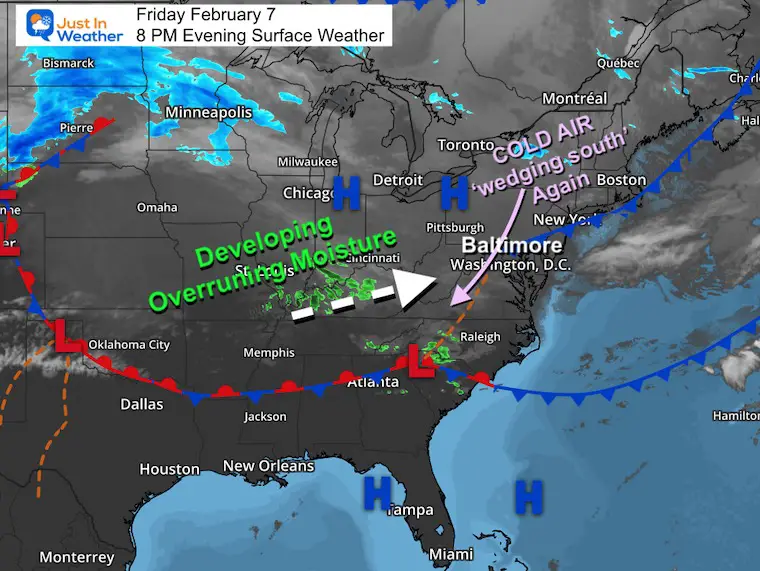
We have another Cold Air ‘wedge’ or Damming situation. This is building south now while a band of precipitation is developing across Kentucky. It may not look like an organized storm yet, but neither did the last event. This is forming the same way and will take shape on Saturday.
I WAS WRONG Saturday Morning… suggesting this would start early. It did in Southern MD, but that split the energy.
The system split its energy AND is running up against a stronger/dry cold air mass.
IT IS STILL FORMING… SLOWLY. This is a lot like what happened two weeks ago…
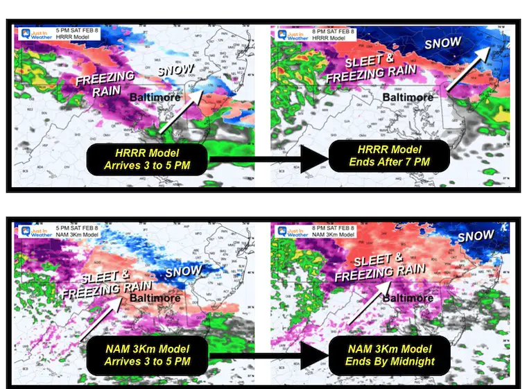
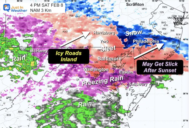
This icy mix will still develop in Central MD to Southern PA 3 PM to 5 PM. The focus is back for late afternoon in the evening.
Model plots here:
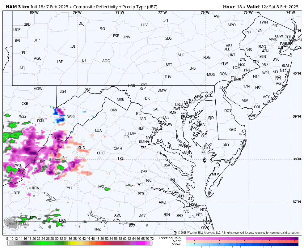
The HRRR Model ends it quickly in a couple of hours. (performed better this morning)
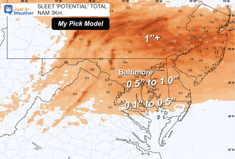
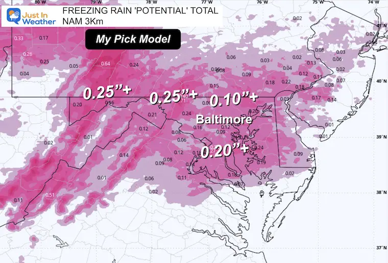
The NAM 3 Km lingers the ice near and North of Baltimore through midnight. (performed worse this morning, the one I showed and believed)
I am showing both so we can look back and see which one performed better. That will help up better with the Tuesday snow as we get closer.
Post on Facebook: If you want to comment….
NAM 3Km
Highlights of this below.
Watch as the light snow and sleet expand to freezing rain during the day and evening. This should mostly end close to midnight.
The impact on roads may be limited during the day; expect more farther inland.
The icing on roads will gradually become and issue during the afternoon into the evening hours.
Please allow me a 1 to 2 hour buffer on that timing.
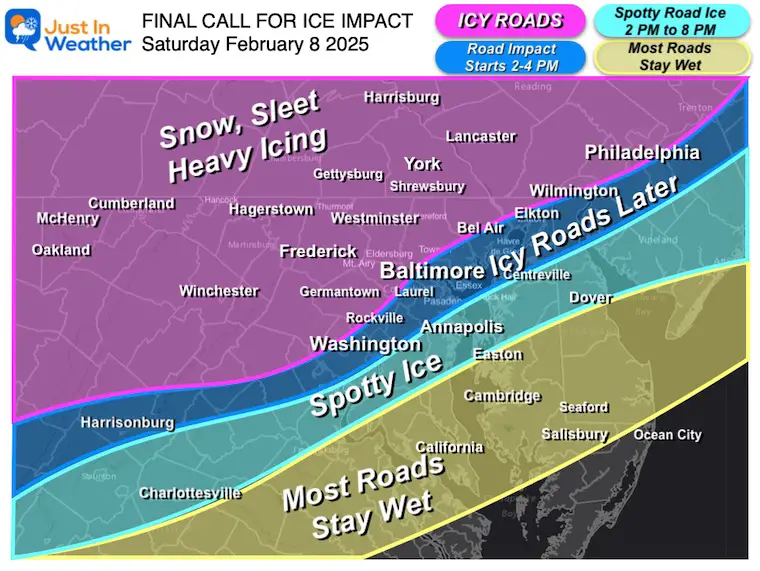
This may begin with brief snow around lunchtime. Then turn to sleet for much of the central areas…
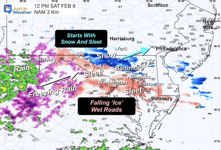
The cold air wedge or Dam will be banked up inland west of I-95 initially.
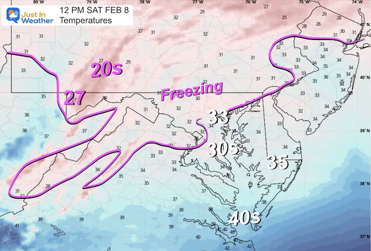
As the sleet and freezing rain get established, temps will cool just below freezing in more areas… to fulfill the Advisory.
Roads may begin to get more slick as the sun gets lower in the sky and then after sunset. This will expand across Central Maryland between 4 PM and 6 PM.
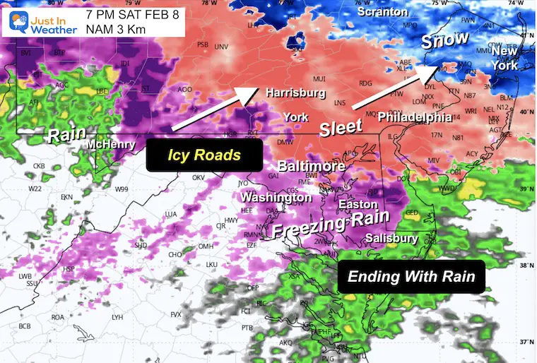

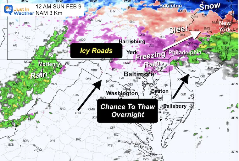
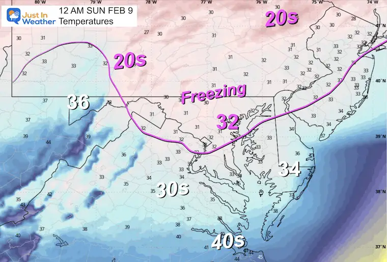
Warmer air should flow in behind the storm. This should help with the thaw on Sunday morning.
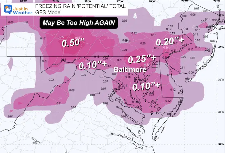
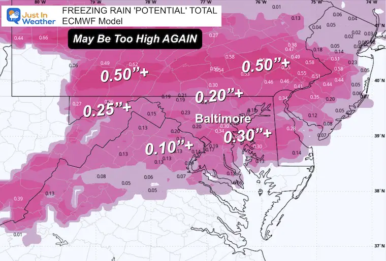
At this point, I see the NAM 3 Km Model having the best solution with the combination of sleet and freezing rain. I am comparing them with the GFS and ECMWF Models for upper-limit reference. Also, those latter models may be overdoing the precipitation totals, which may be important with the snow interpretation next Tuesday.
7 AM Tue to 7 AM Thu
The European Model here shows the active pattern that may blend one storm into the next.
Here, we see the burst of snow on Tuesday, a light icy mix on Wednesday, and then a mix of rain on Thursday.
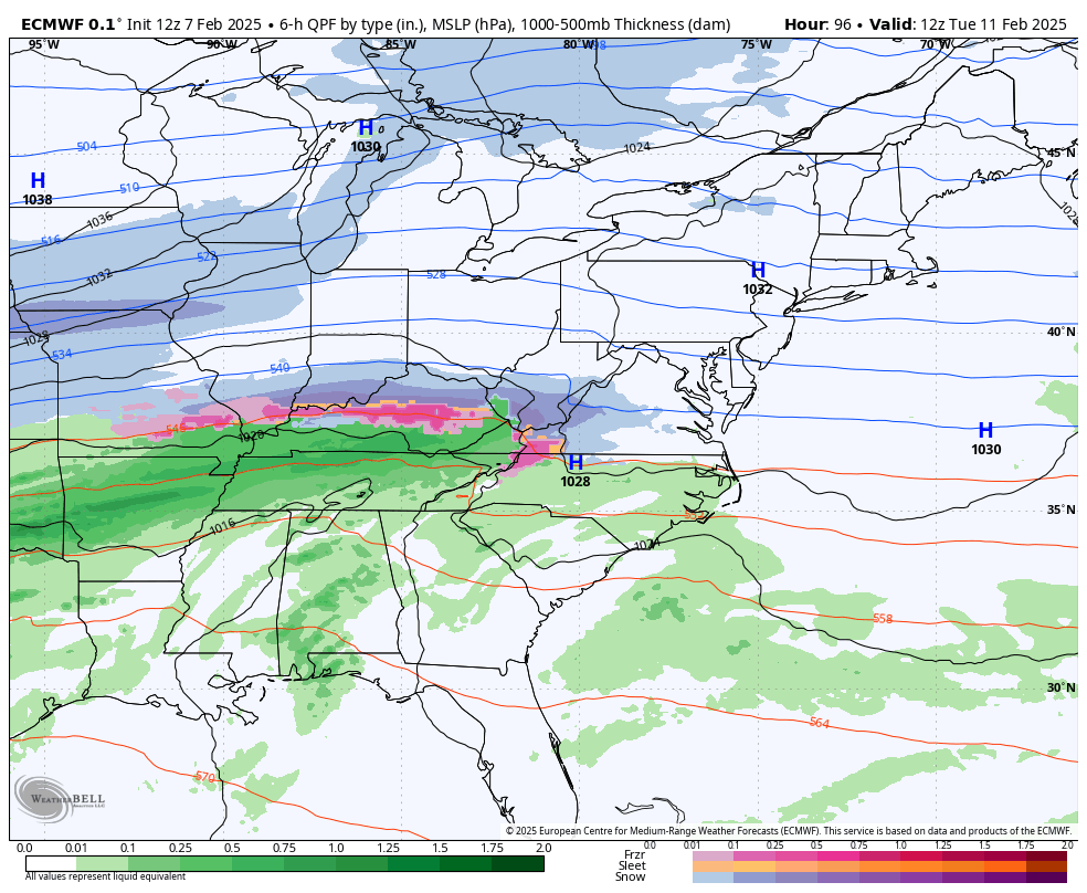
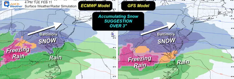
This shows both the ECMWF and GFS Models highlighting the burst of moderate snow to include Central AND Southern Maryland.
It is TOO EARLY to show any snow totals other than my suggestion for OVER 3 inches. That is to help with the idea that there will be enough to shovel or plow.
Computer models have a wide range, and since yesterday, I have already seen large totals on one model cut in half.
Predicting snow beyond 3 days is guesswork and often subject to going too high. I will start to show snow total potential this weekend.
Next ice event on Saturday
Next snow chance on Tuesday…
A few more storms are possible over the next few weeks.


Click on the maps for that full report.


Severe Weather: Storm Smart October and next spring Winter Weather FITF (Faith in the Flakes): November To March Click to see more and send a request for your school.

The annual event: Hiking and biking 329 miles in 7 days between The Summit of Wisp to Ocean City.
Each day, we honor a kid and their family’s cancer journey.
Fundraising is for Just In Power Kids: Funding Free Holistic Programs. I never have and never will take a penny. It is all for our nonprofit to operate.
Click here or the image to donate:

I am aware there are some spelling and grammar typos and occasional other glitches. I take responsibility for my mistakes and even the computer glitches I may miss. I have made a few public statements over the years, but if you are new here, you may have missed it: I have dyslexia and found out during my second year at Cornell University. It didn’t stop me from getting my meteorology degree and being the first to get the AMS CBM in the Baltimore/Washington region. One of my professors told me that I had made it that far without knowing and to not let it be a crutch going forward. That was Mark Wysocki, and he was absolutely correct! I do miss my mistakes in my own proofreading. The autocorrect spell check on my computer sometimes does an injustice to make it worse. I also can make mistakes in forecasting. No one is perfect at predicting the future. All of the maps and information are accurate. The ‘wordy’ stuff can get sticky. There has been no editor who can check my work while writing and to have it ready to send out in a newsworthy timeline. Barbara Werner is a member of the web team that helps me maintain this site. She has taken it upon herself to edit typos when she is available. That could be AFTER you read this. I accept this and perhaps proves what you read is really from me… It’s part of my charm. #FITF