Monday October 11 2021
We are about to bring back a few days of sweating weather then sweater weather returns this weekend. Can you wait a little longer?
There are many names for a warm weather pattern in October. ‘Indian summer’ refers to a string of warm days after the first autumn chill or frost. So, here I am writing this on Columbus Day, which has been renamed Indigenous People’s Day. As a result, I am not sure if this is even appropriate now. However, someone will surely me know what the new rules are.
Now, we are here to talk weather, so I would like to rename this pattern we are in Augtober. I think that is self explanatory and we can get behind that.
Yes, it has been a warm start to October, and it is about to get a little warmer for a few more days. Average high temperatures should be dropping into the upper 60s this week, but instead we will be going up again.
This will pale in comparison to the historic record heat wave showing up this week.
Back in 1954, Baltimore had three days in a row, just under the 90ºF mark.
- 11th = 89ºF
- 12th = 89ºF
- 13th = 89ºF
When we look to our warming trend this week, we can compare the records on the 14th – 17th, before it breaks.
- 14th = 86ºF in 1975
- 15th = 86ºF in 1989 (and other prior dates)
- 16th = 90ºF in 1897
- 17th = 90ºF in 1938
Yes, late summer heat in our area is pretty common. The extreme heat, we may avoid competing with.
Relief In Sight Next Weekend
We must look to the Jet Stream for our changing weather pattern over the weekend. That may seem far away, but for us hungry for some normalcy, it is worth dangling that carrot now.
Jet Stream Animation
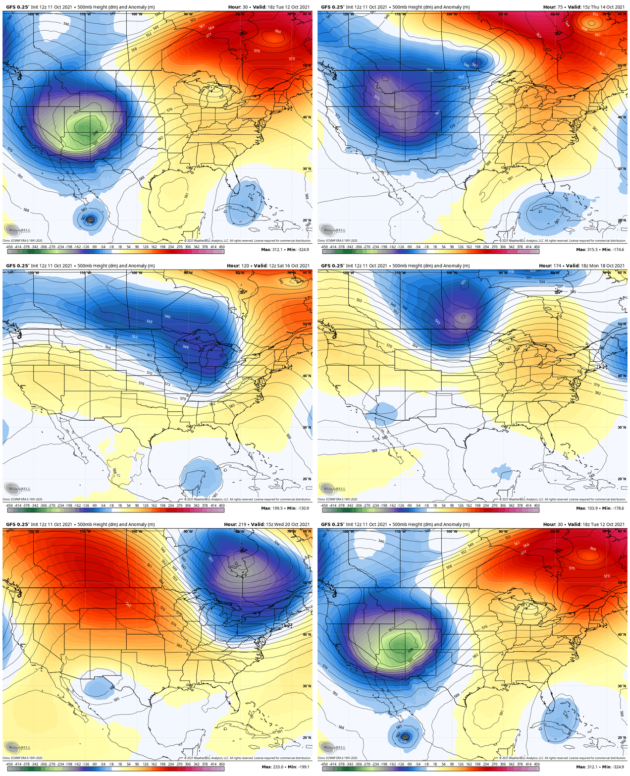
Simply put: Orange and Yellow represent Warm/Ridge, while shades of Blue and Green represent the COLDER/Troughs.
This time period is from Tuesday October 12 through next week. We can see a couple of pushes of colder air.
Cold Front- Saturday Afternoon
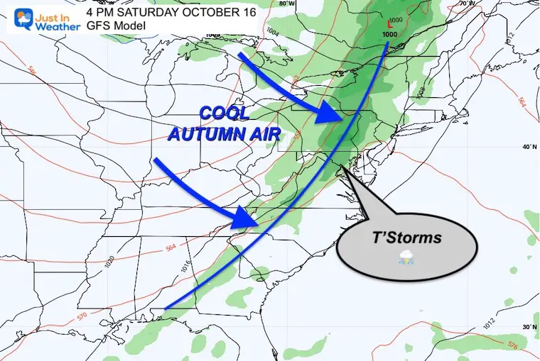
Here is a forecast map 5 days away, so the timing may change. However a strong cold front should arrive with a line of showers and T’storms.
If this holds as an afternoon event, then we can push one more 80ºF + day, and feed storms.
Temperature Animation
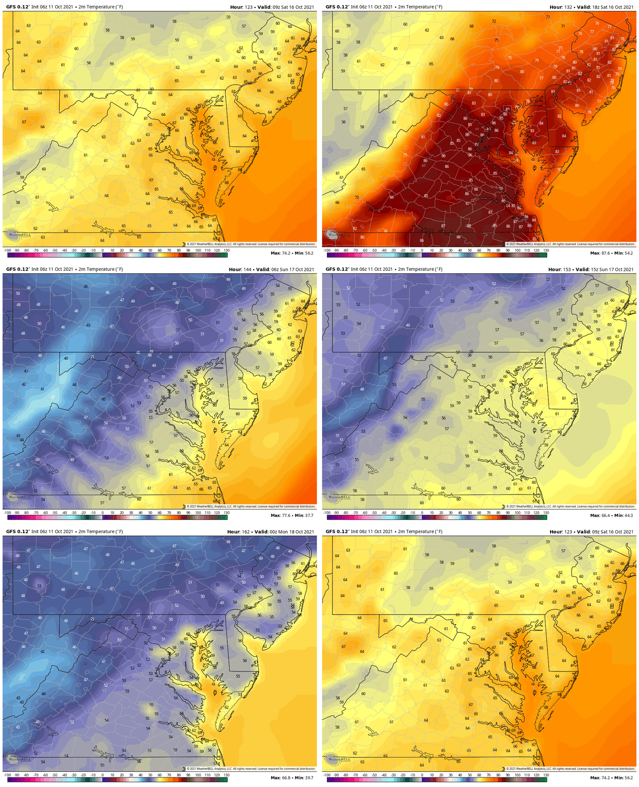
Saturday Morning To Sunday Evening
On this map animation below, we can see the warm start to the weekend Saturday morning, then the drop of temps after the front passes later in the day.
Following this, Sunday will be a cooler day, with highs back in the 60s (near average, but feeling cooler).
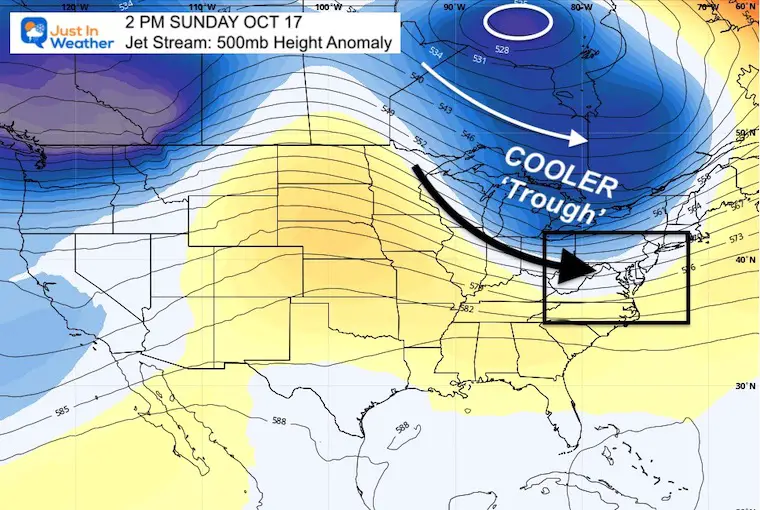
Jet Stream Snapshot
The trough will visit, but not hold. However, the trend knocks us back into a pattern closer to normal.
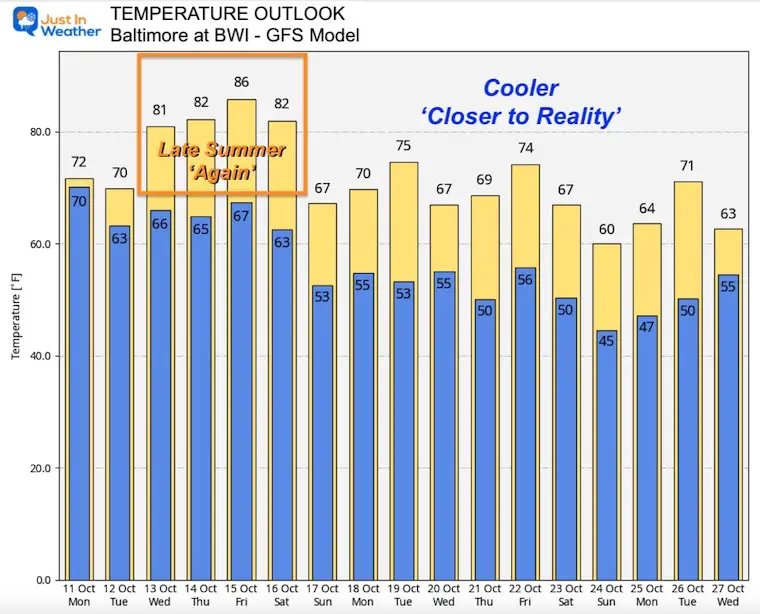
Temperature Outlook (Baltimore)
Below we see the GFS displaying a typical autumn pattern with chilly air, that moderates after a couple of days, only to be followed by even cooler air.
This is one model and one log range outlook. Important to remind you this is set for BWI, the official weather station for central Maryland. That does run a lot warmer than inland ares.
However, it does ‘suggest’ many more days in the 60s and nights in the 50s.
It will be colder inland, away from the cities and the water, where more nights and mornings will be in the 40s.
Not much longer until we can talk snow. #FITF
I am really excited to make my next 7 Day forecast, as it should have some lower numbers in it. That will be ready in my early report on Tuesday Morning. See ya then.
Maryland Trek Gear
Maryland Trek 8 Says THANK YOU!
Running Total Raised $116,438
During 329 Miles From Wisp To Ocean City
To Honor Kids In Cancer Treatment and Support FREE Programs At Just In Power Kids
Please share your thoughts, best weather pics/video, or just keep in touch via social media
Facebook: Justin Berk, Meteorologist
Twitter: @JustinWeather
Instagram: justinweather
Email Updates
Please make sure you sign up (above or click here to sign up for email alerts…. ) for my newsletter. This way you will get an email to make sure you are notified of each post.


