


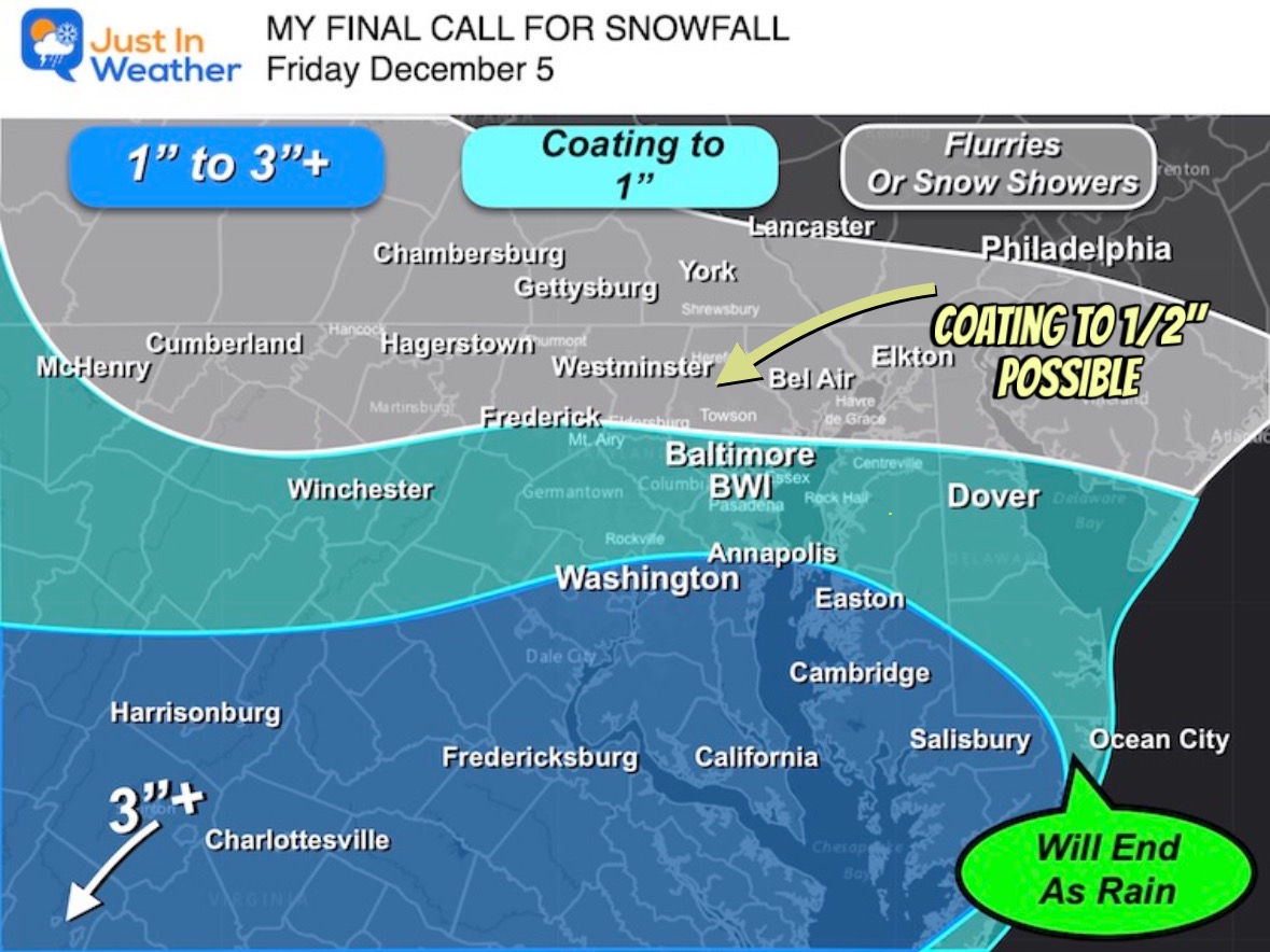
My Call For Snowfall Saturday Morning Inland And Sunday Closer To The Coast
Friday Evening Update January 16 2026 Two weather events will bring snow to our region this weekend. They are related to the fast winds aloft on the edge of this…
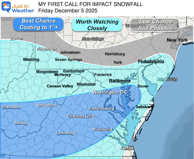
Thursday December 4
Evening Update
Stop me if you’ve heard this before: A little bit of snow can be a big problem, especially when the thing is for a commute, and the temperatures will be cold enough to stick. I wrote that yesterday. I hope you saw my follow-up reports, which focused on this being a morning event (as opposed to the afternoon and evening). Also that this will favor the Southern parts of our region with more snow, while little to no snow farther north.
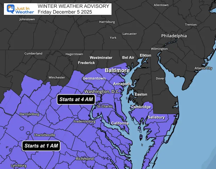
The Winter Weather Advisory includes Washington, Baltimore, and Annapolis for the expected first snow of the season. It will be light, but cold enough to stick. If this verifies, it will be the first December snow in Baltimore in 5 years!
In this report, we will look at the Evening Set Up, compare two radar simulations, my Final Call For Snowfall, and compare 6 model forecast maps to the National Weather Service forecast.
The impact will begin to spread across these areas
Do you remember how special December 5th is for snow? It was the first day for Baltimore almost every year for a decade. It is also the day in 2009 that began Faith in the Flakes with my son. See that story here.
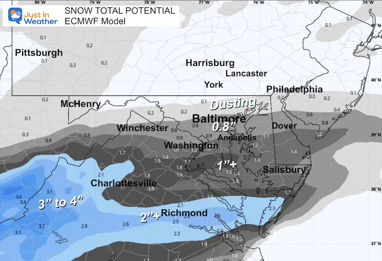
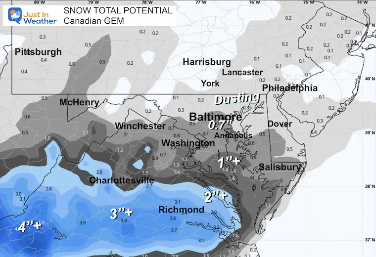
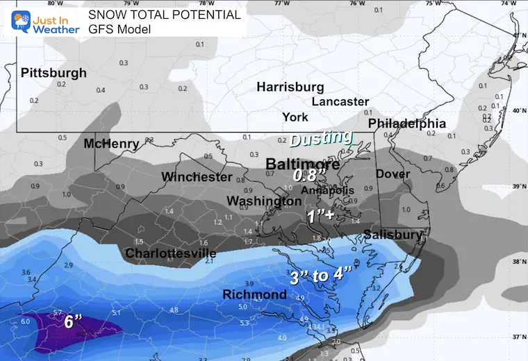
This is very similar to my prior maps, just zoomed in closer.
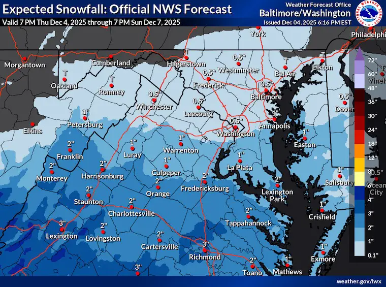
Please see my notes below to compare with my map for any possible errors. I will report my map below to make that contrast easier to view.
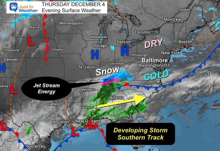
High Pressure is holding the cold and also dry air to the north. The dry portion in Pennsylvania is where the snow cut-off will be.
This is a Southern Track system with Low Pressure located near New Orleans.
Our concern is the snow in Kentucky and Southwest Virginia. That is a response of the upper-level energy I pointed out in my report yesterday. This will be expanding with a modest phasing tonight… will just continue to be a quick mover to the coast.
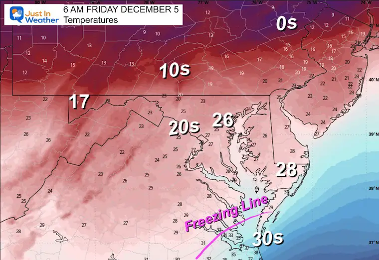
Cold enough for snow stickage with the Freezing Line pushed all the way to Southeast Virginia along the coast.
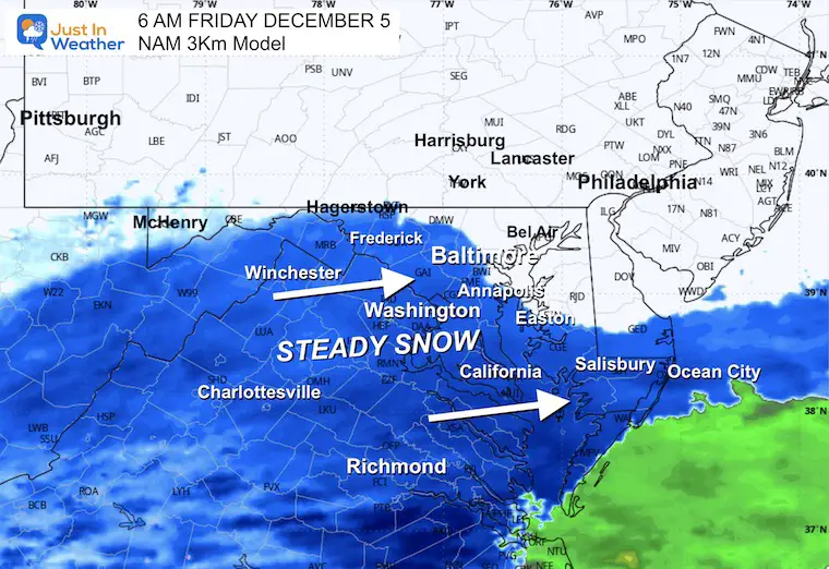
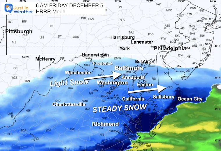
Comparing two high-resolution short-range models, NAM 3Km and HRRR.
There is a subtle difference with the NAM 3Km being a little farther north and more wet. It also responds to upper-level energy to enhance snow showers into Southern Pennsylvania midday, while the HRRR Model is a little farther south AND analyzes the northern fringe as drier.
I am showing both because I see the net results may be a hybrid of these two.
NAM 3Km
The northern edge of the snow reaches the PA line.
HRRR
The northern fringe of snow.
NAM 3Km
Resolves the upper level energy to expand the snow showers and flurries into Southern Pennsylvania in the afternoon.
On the southern edge, warmer air advances across Ocean City and near Salisbury.
HRRR
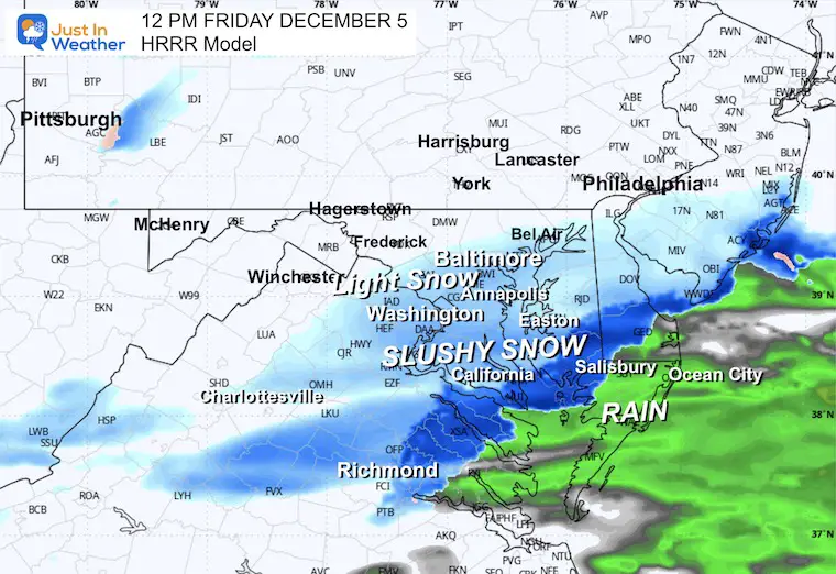
This has been more dry and cutting off the snow sooner. But in the last few hours it has extended the light snow to midday across Central Maryland.
The rain line pushed farther inland through Salisbury towards Seaford, DE.
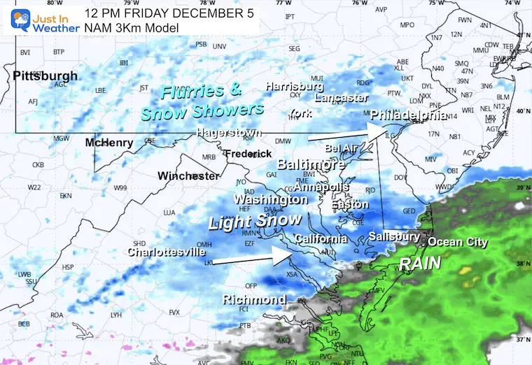
4 PM
The NAM only shown here because it has a longer simulation window, keeps flurries around Central Maryland while rain showers linger at the beach.
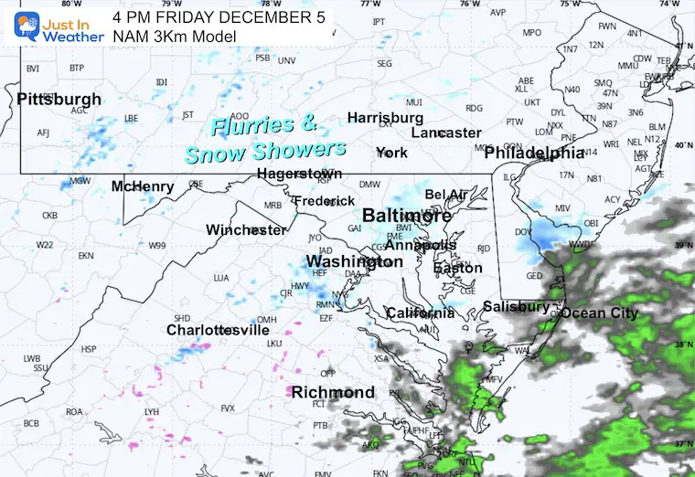
This will be mainly a morning event, breaking up midday. I have accounted for the flurries and snow showers into Pennsylvania, but little to no impact if this lingers into the afternoon.
The rain near the beaches will limit the snow totals there and improve road conditions sooner.
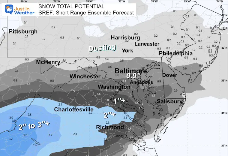
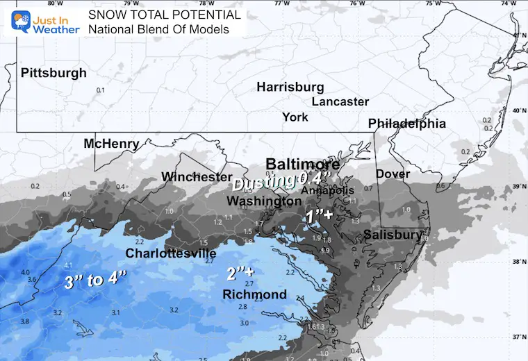
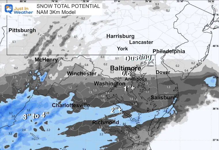
Now that we are right up on the doorstep of the event, there is a lot more agreement. Some subtle differences in the higher snow zone of Virginia.
SREF: Short Range Ensemble Forecast
NBM: National Blend of Models
NAM 3Km
ECMWF Model
Canadian GEM
GFS Model
Wider View
Subscribe for eMail Alerts
Sign up and be the first to know!
Click here for the full report


This was issued October 9, as expected: A weak and short-lived event to start winter may play a different role this winter.

These are NOT all the same caterpillar!


Click to see more and ‘Book’ a visit to your school


The annual event: Hiking and biking 329 miles in 7 days between The Summit of Wisp to Ocean City.
Each day, we honor a kid and their family’s cancer journey.
Fundraising is for Just In Power Kids: Funding Free Holistic Programs. I never have and never will take a penny. It is all for our nonprofit to operate.
Click here or the image to donate:

I am aware there are some spelling and grammar typos and occasional other glitches. I take responsibility for my mistakes and even the computer glitches I may miss. I have made a few public statements over the years, but if you are new here, you may have missed it: I have dyslexia and found out during my second year at Cornell University. It didn’t stop me from getting my meteorology degree and being the first to get the AMS CBM in the Baltimore/Washington region. One of my professors told me that I had made it that far without knowing and to not let it be a crutch going forward. That was Mark Wysocki, and he was absolutely correct! I do miss my mistakes in my own proofreading. The autocorrect spell check on my computer sometimes does an injustice to make it worse. I can also make mistakes in forecasting. No one is perfect at predicting the future. All of the maps and information are accurate. The ‘wordy’ stuff can get sticky. There has been no editor who can check my work while writing and to have it ready to send out in a newsworthy timeline. Barbara Werner is a member of the web team that helps me maintain this site. She has taken it upon herself to edit typos when she is available. That could be AFTER you read this. I accept this and perhaps proves what you read is really from me… It’s part of my charm. #FITF