Sunday Evening September 8, 2024
It has been a very quiet tropical season in the Atlantic so far, but as we reach the historically most active time of the season, there is a new storm likely to be named. As of Sunday evening, this was labeled Potential Tropical Cyclone Six (PTC6). It is gradually organizing and computer model guidance has it become a tropical storm on Monday. This is expected to quickly become a hurricane before making landfall on the US coast near somewhere between Houston and New Orleans.
The interesting feature here is that winds are already fast enough, sustained at 50 mph. The reason it has not been named yet has to do with the structure around an organized central low pressure. That should happen in less than 24 hours of this report.
Below is a look at the latest satellite loop, forecast maps, and interactive Windy widget.
Recap Of The 2024 Atlantic Tropical Season So Far:
Named Storms
- Alberto June 19 to 20; Peaked As Tropical Storm
- Beryl June 28 to July 11; Peaked As Cat 5 Hurricane
- Chris June 30 to July 1; Peaked As Tropical Storm
- Debby August 3 to 9; Peaked as a Category 1 Hurricane
- Ernesto August 12 to 20; Peaked As Cat 2 Hurricane
Sunday Evening Snapshot
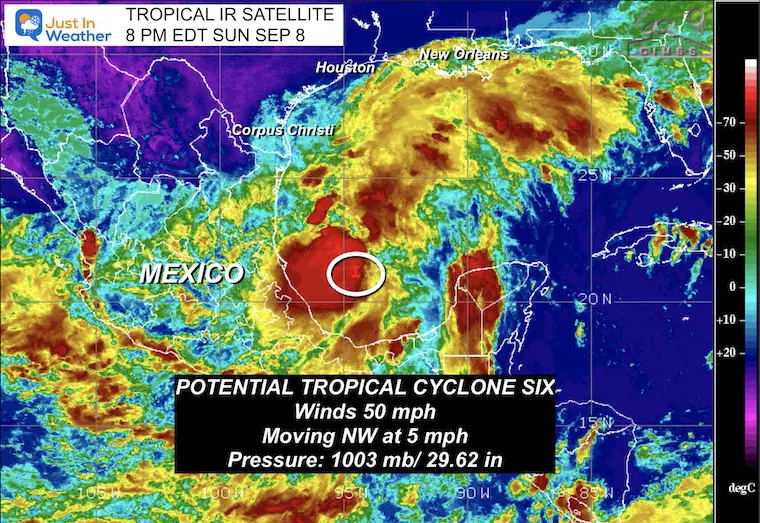
National Weather Service Report
SUMMARY OF 700 PM CDT (8 PM EDT
———————————————-
- LOCATION…21.9N 94.7W
- ABOUT 320 MI…510 KM SSE OF MOUTH OF THE RIO GRANDE
- ABOUT 555 MI…895 KM S OF PORT ARTHUR TEXAS
- MAXIMUM SUSTAINED WINDS…50 MPH…85 KM/H
- PRESENT MOVEMENT…NW OR 320 DEGREES AT 5 MPH…7 KM/H
- MINIMUM CENTRAL PRESSURE…1003 MB…29.62 INCHES
Satellite Loop Sunday Evening
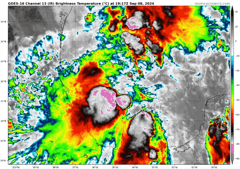
Notes:
Tropical Storm Force winds extend 185 miles away from the center.
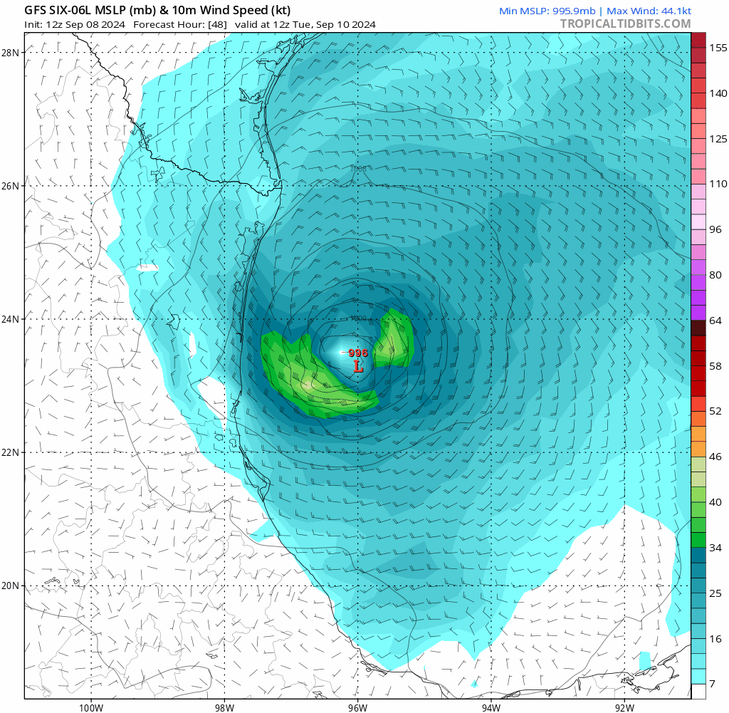
This storm has warm water and light upper-level winds to support rapid development. However, it does not have much room to work with. There is an indication that it will quickly become a hurricane when winds exceed 74 mph late Tuesday or early Wednesday. But then it will run into the US coastline.
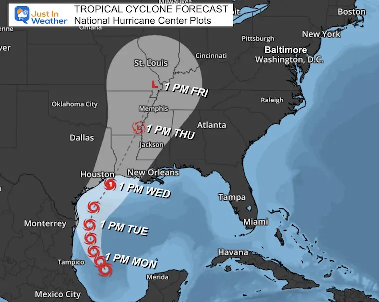
It is a large system that will bring heavy rain and potential flooding to Texas and Louisiana on Tuesday and Wednesday. The system will move inland to the North and quickly weaken.
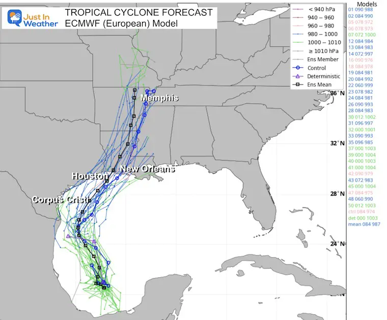
National Hurricane Center Forecast Track/Cone
I’ve plotted this on a closer map with the times highlighted. Note that the cone of uncertainty allows for fluctuations in the track, so it’s best not to focus on just the center.
Also, the heaviest rain and fastest winds will likely be on the North and East sides of the central Low Pressure, with less on the west side.
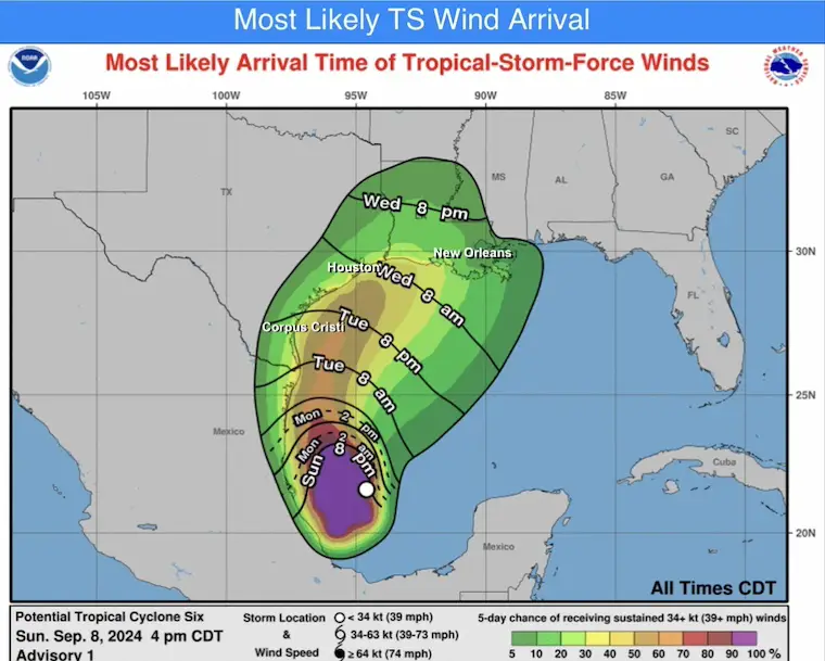
Wind Forecast (Above Tropical Storm Intensity)
Windy INTERACTIVE Forecast Widget
Computer Model Forecasts
ECMWF (European) Model
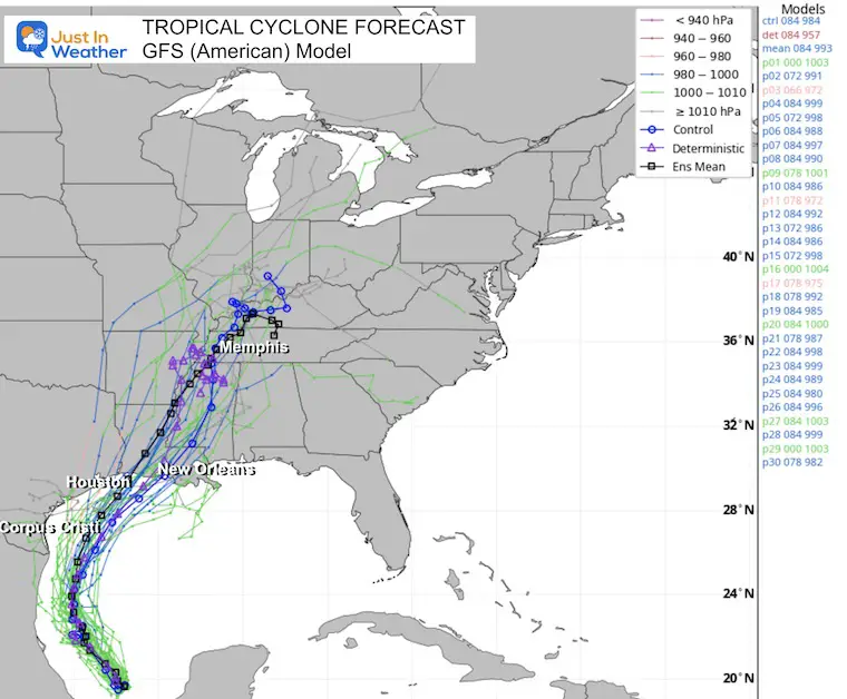
GFS (American) Model
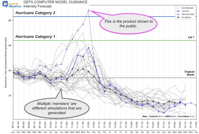
GEFS Model Forecast Intensity
Looking at all of the simulations run by the GEFS Model may look like a lot of noise. The Purple line is the Deterministic plot, which is shown to the public. This shows the potential to reach Category 2 intensity (wind 96 mph or higher) just before landfall early Thursday morning.
GEFS (American) Model Forecast Animation:
Tuesday Through Thursday
Note: This is centered on the center of the storm, so the map location will move.
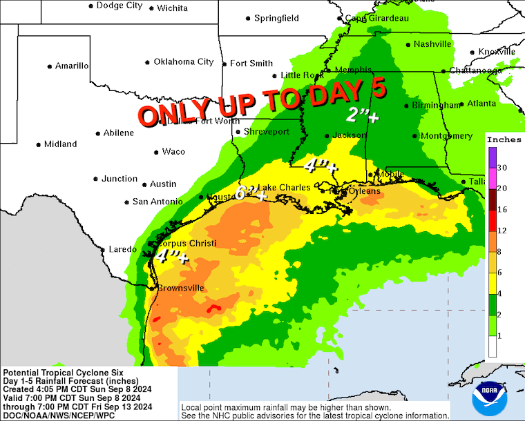
NOAA Rainfall Outlook:
Note this only goes out to 5 Days and may not include the inland impact before dissipating completely.
Notice the rapid drop off of rain just inland from the Texas coast. The track will make a big difference in rainfall on that side.
If You Missed It
Click here to see: NOAA Released Its Most Aggressive Hurricane Season Forecast
THANK YOU:
Baltimore Magazine Readers Choice Best Of Baltimore
Maryland Trek 11 Day 7 Completed Sat August 10
We raised OVER $104,000 for Just In Power Kids – AND Still Collecting More
The annual event: Hiking and biking 329 miles in 7 days between The Summit of Wisp to Ocean City.
Each day, we honor a kid and their family’s cancer journey.
Fundraising is for Just In Power Kids: Funding Free Holistic Programs. I never have and never will take a penny. It is all for our nonprofit to operate.
Click here or the image to donate:

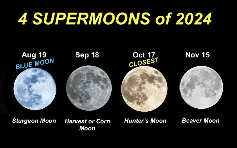
Four Supermoons In A Row
See more about the 4 Supermoons Through November here:
Please share your thoughts and best weather pics/videos, or just keep in touch via social media.
RESTATING MY MESSAGE ABOUT DYSLEXIA
I am aware there are some spelling and grammar typos and occasional other glitches. I take responsibility for my mistakes and even the computer glitches I may miss. I have made a few public statements over the years, but if you are new here, you may have missed it: I have dyslexia and found out during my second year at Cornell University. It didn’t stop me from getting my meteorology degree and being the first to get the AMS CBM in the Baltimore/Washington region.
One of my professors told me that I had made it that far without knowing and to not let it be a crutch going forward. That was Mark Wysocki, and he was absolutely correct! I do miss my mistakes in my own proofreading. The autocorrect spell check on my computer sometimes does an injustice to make it worse. I also can make mistakes in forecasting. No one is perfect at predicting the future. All of the maps and information are accurate. The ‘wordy’ stuff can get sticky.
There has been no editor who can check my work while writing and to have it ready to send out in a newsworthy timeline. Barbara Werner is a member of the web team that helps me maintain this site. She has taken it upon herself to edit typos when she is available. That could be AFTER you read this. I accept this and perhaps proves what you read is really from me… It’s part of my charm. #FITF


