Monday July 8, 2024
Morning Report
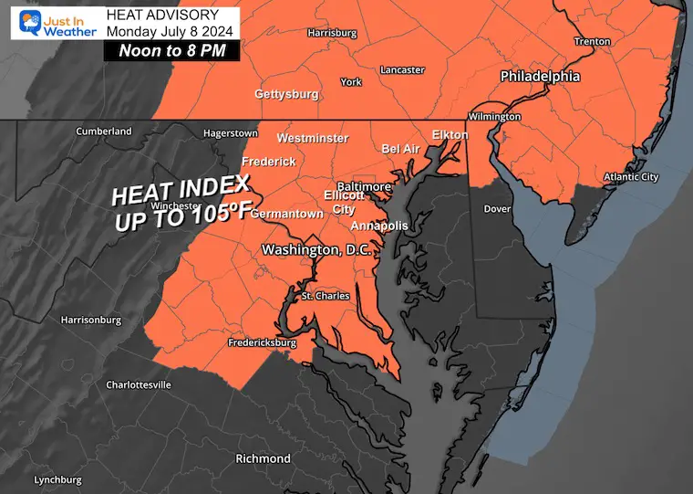
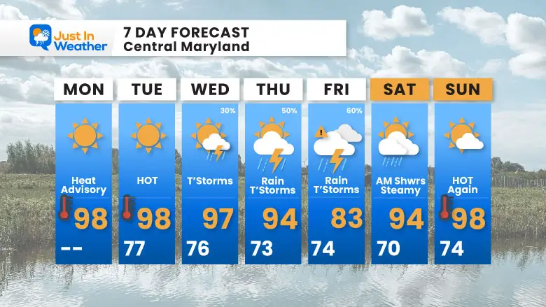
Baltimore hit 97ºF yesterday for the second time this summer. The latest numbers for BWI also show 20 days total at or above 90ºF. Today, we will add another to the list, and the humidity will make it feel like 105ºF, which has prompted a Heat Advisory.
The heat will remain, and the humidity will increase during the week. This is thanks in part to the inland push of Beryl, which may bring welcome rain from thunderstorms to our region for many days. Here is a brief look at the system, with the full analysis and forecast below.
Hurricane Storm Beryl
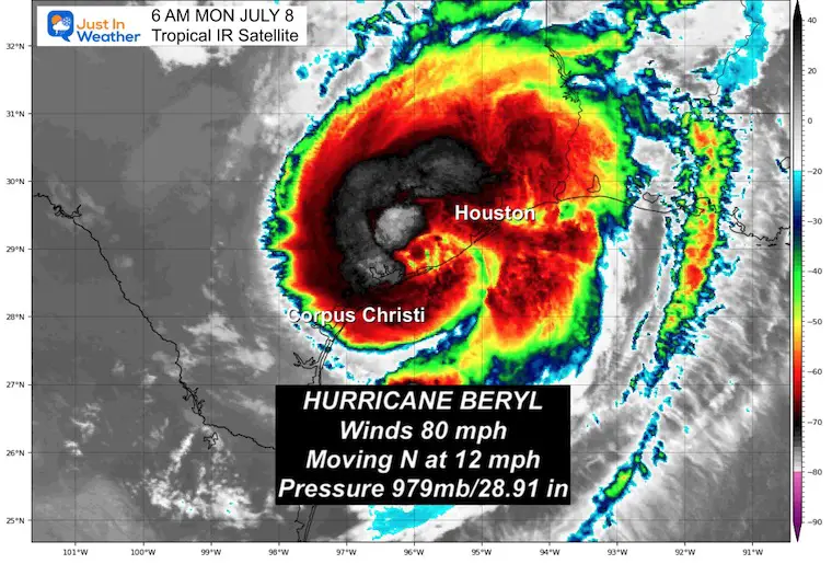
With winds up to 80 mph, Category 1 Hurricane Beryl made landfall this morning just before 5 AM around Matagorda, TX. Dangerous Storm Surge up to 7 Ft along the coast with rainfall ranging from 5 to 15 inches. Flood warnings include Houston this morning. This is the same area that was affected by Alberto a few weeks ago AND has been subjected to flooding rains for months.
More on this storm below.
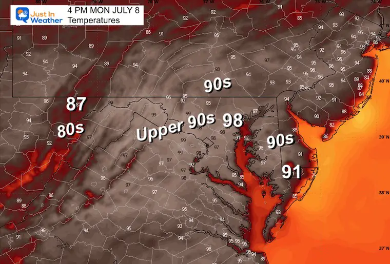
Today’s Weather
It will be hot, humid, and very uncomfortable! It is even dangerous for many to be outside for an extended period of time. As Beryl continues to move inland to the North, some of that moisture may influence our weather in the week ahead.
Heat Advisory
Afternoon Heat Index values will be close to 105ºF.
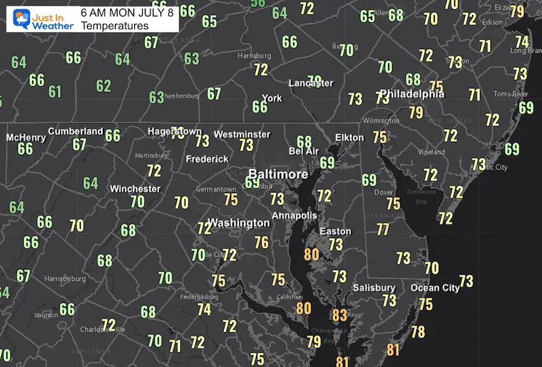
Morning Temperatures
Another Very Warm Start
Morning Surface Weather
Afternoon Temperatures
CLIMATE DATA: Baltimore
TODAY July 8
Sunrise at 5:48 AM
Sunset at 8:35 PM
Normal Low in Baltimore: 68ºF
Record 53ºF in 2000
Normal High in Baltimore: 89ºF
Record 100ºF 1993; 2012
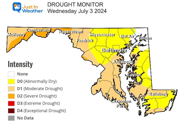
Drought Monitor
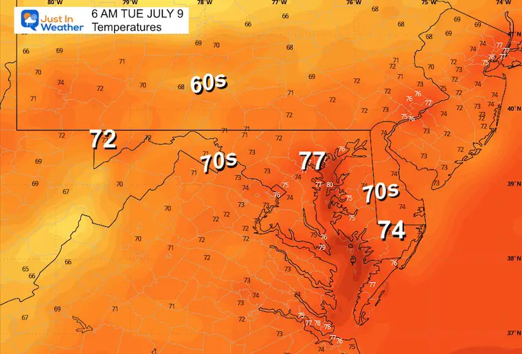
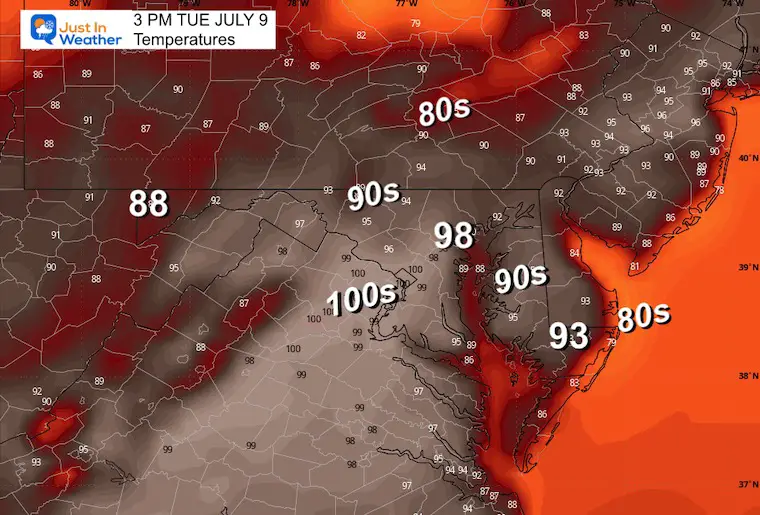
TUESDAY JULY 9
Hot and Humid AGAIN
Morning Temperatures
Afternoon Temperatures
Tropical Storm Beryl
Tropical Storm Beryl made landfall this morning just before 5 AM around Matagorda, TX, with a Dangerous Storm Surge up to 7 Ft along the coast with rainfall ranging from 5 to 15 inches. Flood warnings included Houston this morning.
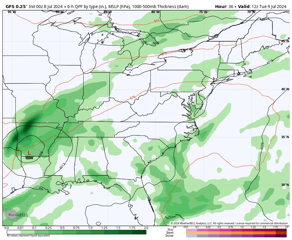
It will move inland through Texas, up the Mississippi River Valley, and towards the Great Lakes. The widespread impact will increase tropical moisture across the Eastern US all week ahead.
Morning Satellite Loop
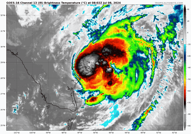
SUMMARY OF 400 AM CDT…0900 UTC…INFORMATION
———————————————-
LOCATION…28.6N 96.0W
ABOUT 0 MI...0 KM N OF MATAGORDA TEXAS
ABOUT 85 MI...135 KM SSW OF HOUSTON TEXAS
MAXIMUM SUSTAINED WINDS…80 MPH…130 KM/H
PRESENT MOVEMENT...N OR 355 DEGREES AT 12 MPH…19 KM/H
MINIMUM CENTRAL PRESSURE…979 MB…28.91 INCHES
LIVE RADAR and LIGHTNING WIDGET
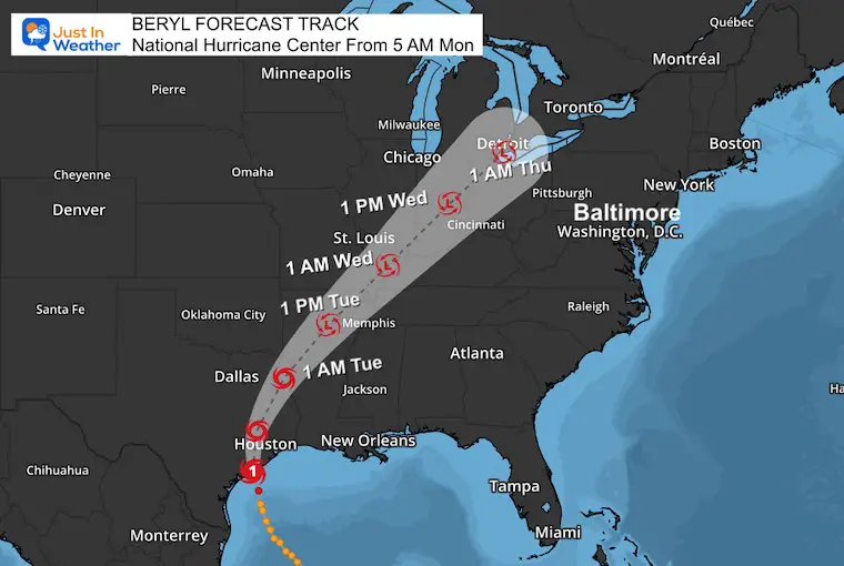
National Hurricane Center Forecast Track
This will quickly weaken and be downgraded to a Tropical Storm today and then a Depression as it moves inland to the North this week. Plenty of heavy rain will continue to fall along its path.
STORM SURGE:
The combination of storm surge and tide will cause normally dry areas near the coast to be flooded by rising waters moving inland from the shoreline. The water could reach the following heights above ground somewhere in the indicated areas if the peak surge occurs at the time of high tide…
- Port O’Connor, TX to San Luis Pass, TX…4-7 ft
- Matagorda Bay…4-7 ft
- San Luis Pass, TX to High Island, TX…4-6 ft
- Galveston Bay…4-6 ft
- Mesquite Bay, TX to Port O’Connor, TX…3-5 ft
- High Island, TX to Sabine Pass, TX…3-5 ft
SUMMARY OF WATCHES AND WARNINGS IN EFFECT:
A Storm Surge Warning is in effect for…
* Mesquite Bay to Sabine Pass, including Matagorda Bay and Galveston Bay
A Hurricane Warning is in effect for…
* The Texas coast from Mesquite Bay northward to Port Bolivar
A Tropical Storm Warning is in effect for…
* The Texas coast north of Port Bolivar to Sabine Pass
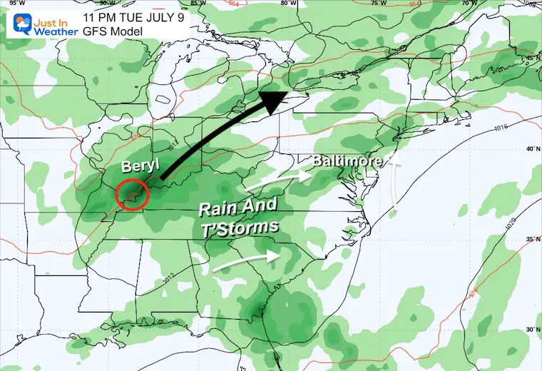
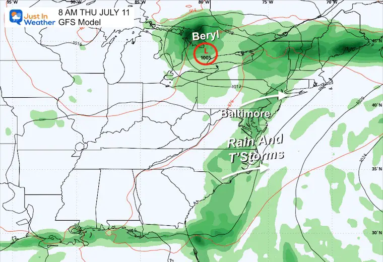
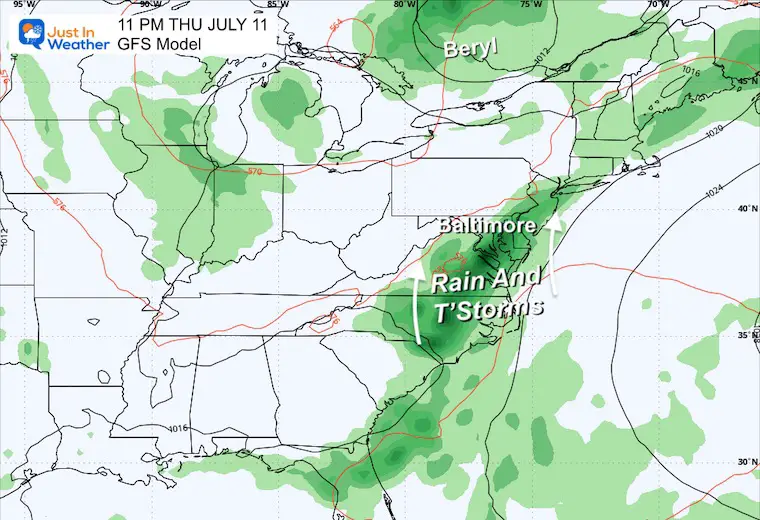
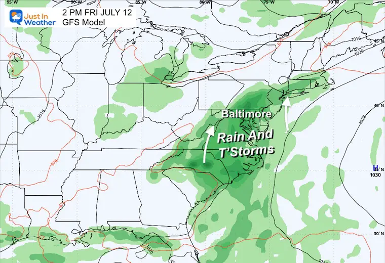
Local Impact: Tuesday to Saturday
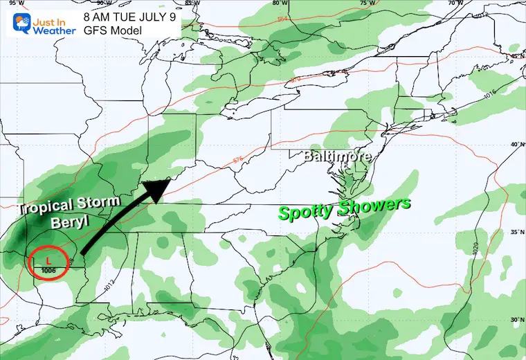
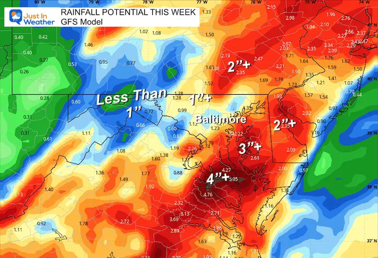
As the remains of Beryl track towards Michigan, we can see some influence from Beryl adding tropical moisture along the frontal boundary… This may slow down or stall on Thursday and Friday. We will NOT get the storm in an organized form, but we will see more thunderstorms each day through Friday.
Snapshots
Tuesday Morning
Tuesday Night
Thursday Morning
Thursday Night
Friday Afternoon
Total Rainfall Potential
7 Day Forecast
Temperatures remain hot, with an increased chance of storms later in the week. This will come with increased heat and humidity as an indirect result of Beryl.
Please share your thoughts and best weather pics/videos, or just keep in touch via social media
RESTATING MY MESSAGE ABOUT DYSLEXIA
I am aware there are some spelling and grammar typos and occasional other glitches. I take responsibility for my mistakes and even the computer glitches I may miss. I have made a few public statements over the years, but if you are new here, you may have missed it: I have dyslexia and found out during my second year at Cornell University. It didn’t stop me from getting my meteorology degree and being the first to get the AMS CBM in the Baltimore/Washington region.
One of my professors told me that I had made it that far without knowing and to not let it be a crutch going forward. That was Mark Wysocki, and he was absolutely correct! I do miss my mistakes in my own proofreading. The autocorrect spell check on my computer sometimes does an injustice to make it worse. I also can make mistakes in forecasting. No one is perfect at predicting the future. All of the maps and information are accurate. The ‘wordy’ stuff can get sticky.
There has been no editor who can check my work while writing and to have it ready to send out in a newsworthy timeline. Barbara Werner is a member of the web team that helps me maintain this site. She has taken it upon herself to edit typos when she is available. That could be AFTER you read this. I accept this and perhaps proves what you read is really from me… It’s part of my charm. #FITF


