Tuesday Evening July 2 2024
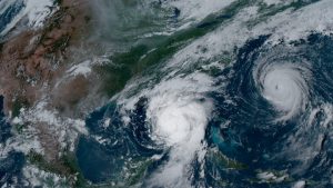
After Hurricane Beryl reached Category 5 for the first time on record in the Atlantic during July, it peaked at 165 mph sustained winds. It passed Grenada’s Carriacou Island on Monday with 150 mph winds, the strongest on record dating back to 1851.
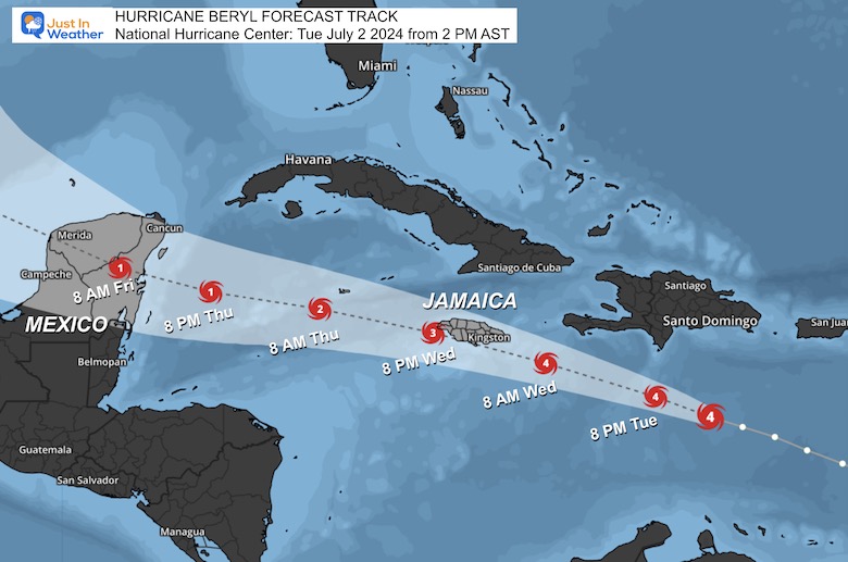
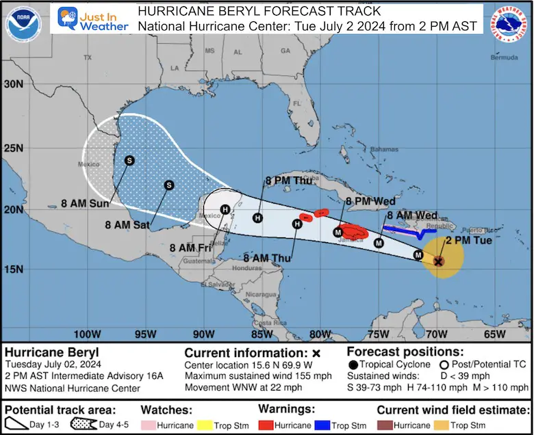
A Hurricane Warning has been issued for Jamaica, where landfall is expected on Wednesday. At this time, the storm may weaken a little but will remain a powerful Category 3. The next warnings in its path will be the Grand Cayman and Little Cayman islands.
Storm surge may be a devastating 5 to 8 Feet above normal tide.
Rainfall will range from 4 to 12 inches due to the impact of mountains.
After the Grand Cayman and Little Cayman islands, it is forecast to land and cross Mexico’s Yucatan Peninsula just south of Cancun and Cozumel. This may bring the highest storm surge and rainfall across the resorts.
It will reemerge over water and might turn towards Texas later in the weekend and early next week with flooding rain.
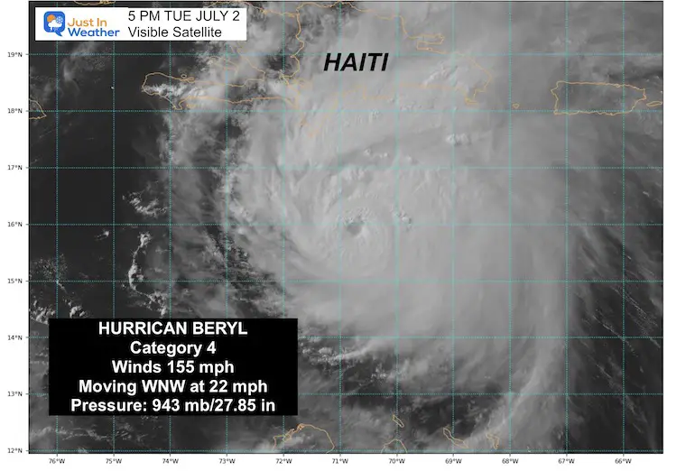
Afternoon Visible Satellite Snapshot
5 PM EDT
We can see the eye is more obscured with high clouds compared to the distinct clearing yesterday and this morning. This is a signal of the past peak status and some weakening.
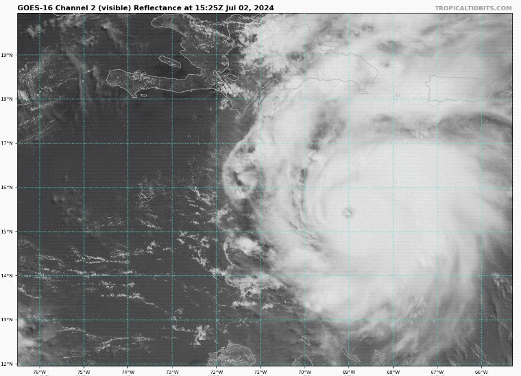
Satellite Loop 10:30 AM to 4:45 PM
The storm footprint is getting a little larger. This is expected with slight weakening, it will spread out. Hurricane-force winds extend 40 miles from the center. Tropical Storm force winds reach 185 miles from the center.
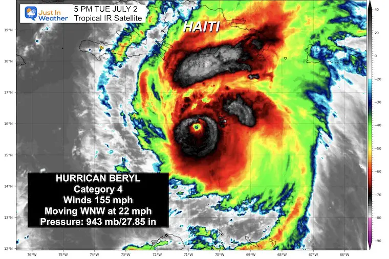
Afternoon Infrared Satellite Snapshot
5 PM EDT
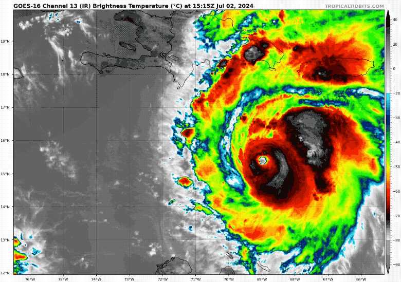
It is no longer symmetrical, with more convection on the west or right side. This is a response to an upper-level wind sheer interfering with the storm structure.
Satellite Loop 10:30 AM to 4:45 PM
SUMMARY OF 500 PM EDT…2100 UTC…INFORMATION
———————————————-
- LOCATION…15.9N 70.8W
- ABOUT 125 MI…205 KM SSE OF ISLA BEATA DOMINICAN REPUBLIC
- ABOUT 420 MI…680 KM ESE OF KINGSTON JAMAICA
- MAXIMUM SUSTAINED WINDS…155 MPH…250 KM/H
- PRESENT MOVEMENT...WNW OR 290 DEGREES AT 22 MPH…35 KM/H
- MINIMUM CENTRAL PRESSURE…943 MB…27.85 INCHES
National Hurricane Center Forecast Track: Close
Here, we see Jamaica next in line and why they have a Hurricane Warning in place. While weakening as it touches the southern part of the island nation, this Major Hurricane may be a lower Category 3 with winds down to 115 to 125 mph.
STORM SURGE:
Storm surge could raise water levels by as much as 5 to 8 feet above normal tide levels in areas of onshore winds along the immediate coast of Jamaica.
Storm surge could raise water levels by as much as 2 to 4 feet above normal tide levels in areas of onshore winds along the immediate coast of the Cayman Islands.
Storm surge could raise water levels by as much as 1 to 3 feet above ground level in areas of onshore winds along the southern coast of Hispaniola.
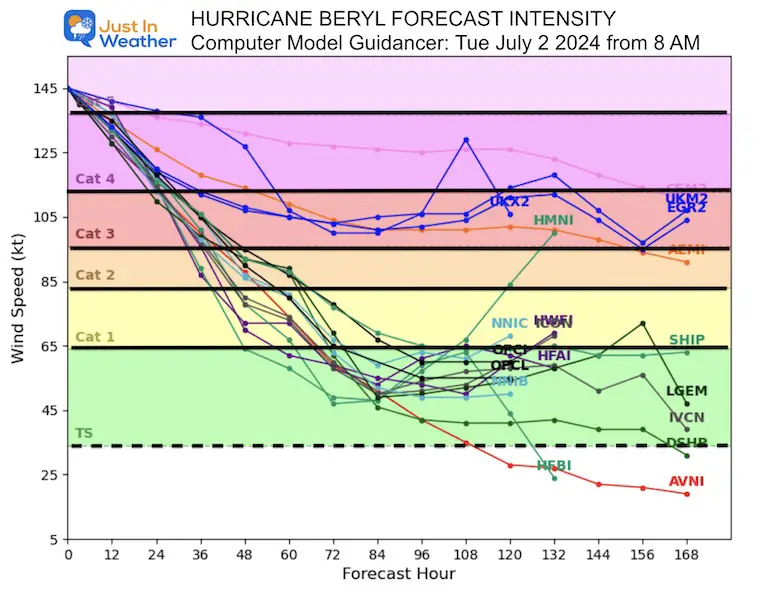
Forecast Intensity
National Hurricane Center Forecast Track 5 Days
While remaining a hurricane, it is expected to drop further down to Cat 1 or 2 when it reaches Mexico near or SOUTH of Cancun and Cozumel Friday morning.
After crossing the Yucatan Peninsula, it will weaken and then reemerge over the Bay of Campeche as a Tropical Storm.
This is where it may turn northwest toward Texas… but could remain a tropical storm… If it strengthens again, it might reach back to Category 1 Hurricane intensity.
RAINFALL:
Hurricane Beryl is expected to produce rainfall totals of 4 to 8 inches, with localized maxima of 12 inches, across Jamaica and southwestern Haitian Peninsula through late Wednesday. Beryl will also produce rainfall amounts of 4 to 8 inches with isolated amounts of 10 inches across Barahona Peninsula in southwest Dominican Republic. Isolated totals of 6 inches or more are also anticipated across the mountainous terrain in the central Dominican Republic. This rainfall is likely to cause flash flooding and mudslides. Beryl is also expected to produce rainfall totals of 2 to 4 inches with localized maxima of 6 inches over the Cayman Islands Wednesday into Thursday.
SUMMARY OF WATCHES AND WARNINGS IN EFFECT:
A Hurricane Warning is in effect for…
* Jamaica
A Hurricane Watch is in effect for…
* Grand Cayman
* Little Cayman and Cayman Brac
A Tropical Storm Warning is in effect for…
* South coast of Dominican Republic from Punta Palenque westward to the border with Haiti
* South coast of Haiti from the border with the Dominican Republic to Anse d’Hainault
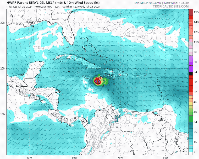
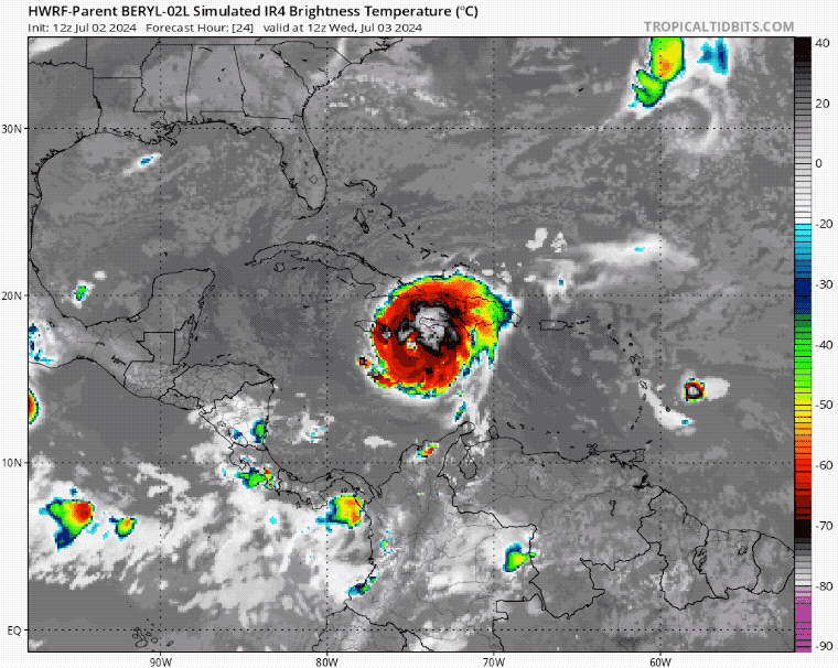
HWRF Model PLOTS
Computer Model SIMULATED Surface and Wind Speed
Wed July 3 to Sun July 7
Computer Model SIMULATED Satellite
Wed July 3 to Sun July 7
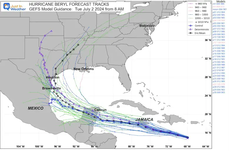
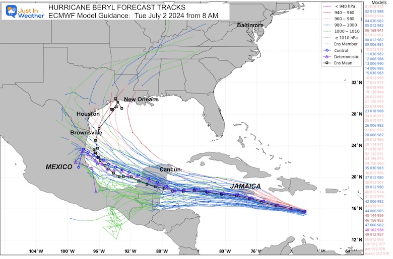
Long Range Computer Model Forecast Tracks
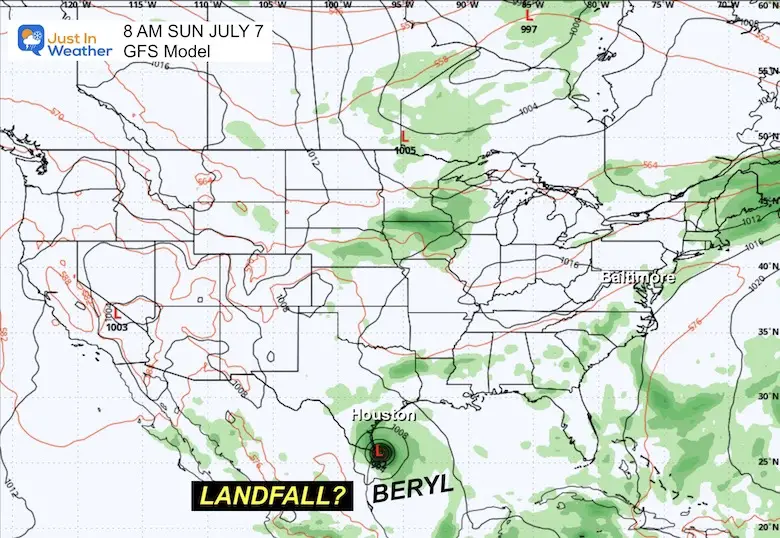
The forecast accuracy decreases after 5 days. However, the trend does pull Beryl North towards Texas… The latest suggestion here is different from this morning’s report… It shows the moisture staying across Texas and the Southern Plains for a few days.
GFS Model Ensemble
ECMWF Model Ensemble
LONG RANGE POTENTIAL: Sunday Morning To Tuesday Evening
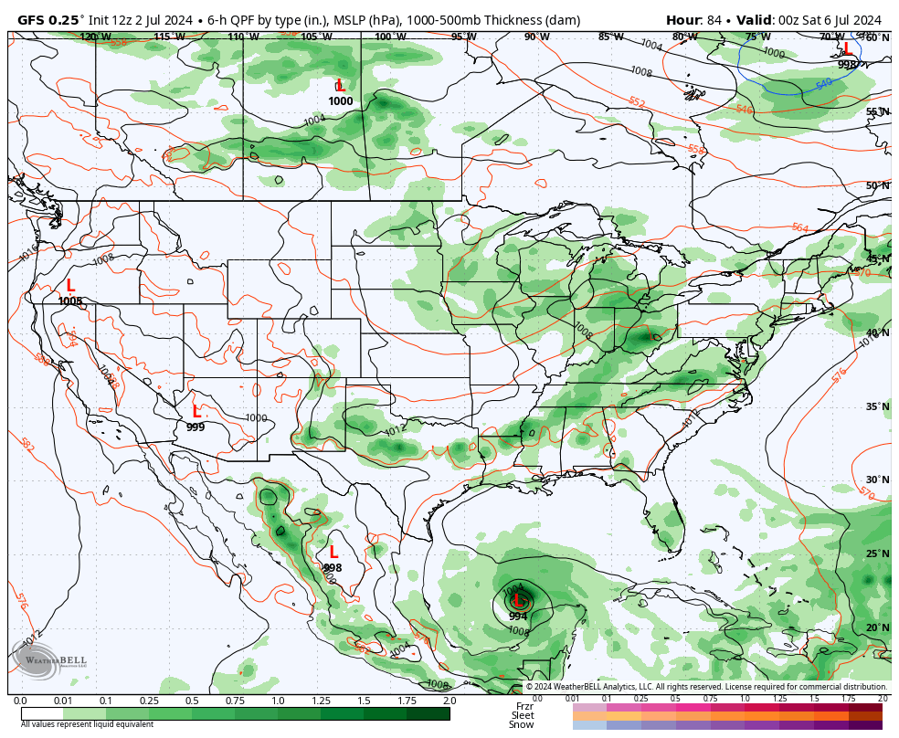
GFS Model Plot
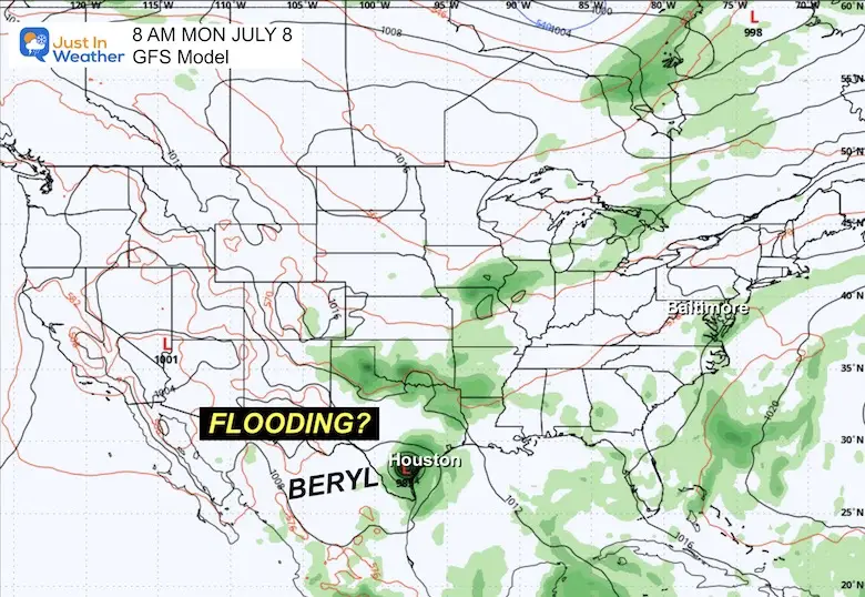
Note: The model is different than the tropical models seen above.. so the timing may be different. The biggest factor will be the timing and location of the inland cold front and jet stream trough. Where it will be located AND where Beryl will be will both determine the influence of tracking inland.
The final landfall may be close to Brownsville or Houston, Texas, in a diminished form. This is farther west than the tropical plots, using different setup formulas and influence (or lack thereof) from inland systems.
At this point, we may see it as a Tropical Storm or Category 1 Hurricane…. Then, the moisture could get picked up by the Cold Front/Trough to the North. This could pull the tropical moisture inland and towards the Mid-Atlantic early next week.
Snapshot ‘SUGGESTIONS’
Sunday Morning, July 7
Monday Morning, July 8
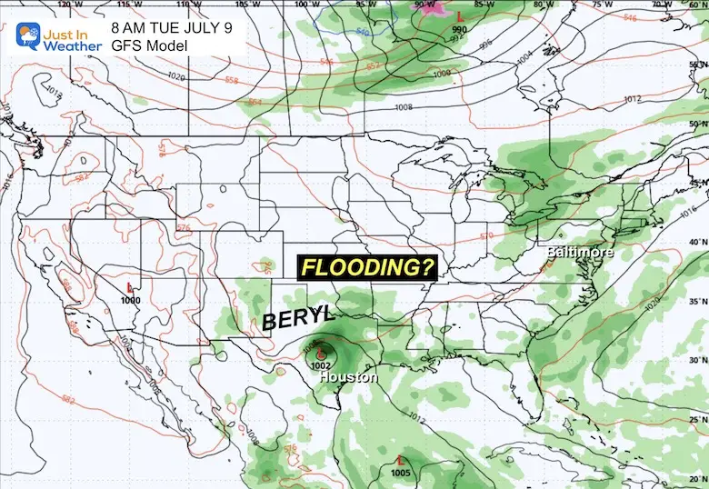
Tuesday Morning, July 9
If You Missed It: Click To See
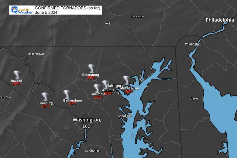
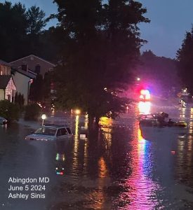
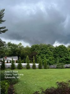
June 5 Storm Report (Preliminary) With Videos And Photos
Hurricane Season Outlook
Click to read: NOAA Releases Most Aggressive Outlook
Please share your thoughts and best weather pics/videos, or just keep in touch via social media
RESTATING MY MESSAGE ABOUT DYSLEXIA
I am aware there are some spelling and grammar typos and occasional other glitches. I take responsibility for my mistakes and even the computer glitches I may miss. I have made a few public statements over the years, but if you are new here, you may have missed it: I have dyslexia and found out during my second year at Cornell University. It didn’t stop me from getting my meteorology degree and being the first to get the AMS CBM in the Baltimore/Washington region.
One of my professors told me that I had made it that far without knowing and to not let it be a crutch going forward. That was Mark Wysocki, and he was absolutely correct! I do miss my mistakes in my own proofreading. The autocorrect spell check on my computer sometimes does an injustice to make it worse. I also can make mistakes in forecasting. No one is perfect at predicting the future. All of the maps and information are accurate. The ‘wordy’ stuff can get sticky.
There has been no editor who can check my work while writing and to have it ready to send out in a newsworthy timeline. Barbara Werner is a member of the web team that helps me maintain this site. She has taken it upon herself to edit typos when she is available. That could be AFTER you read this. I accept this and perhaps proves what you read is really from me… It’s part of my charm. #FITF


