Sub-Tropical Storm Nicole Named: May Hit Florida As A Hurricane Then Up East Coast
Monday November 7 2022
As of the 5 AM report, the National Hurricane Center has officially named Nicole a subtropical storm. This is the same wind intensity as a tropical storm, this one measured at 45 mph winds. The difference is the structure which is a hybrid with cold core elements.
Nicole is forecast to intensify and might reach hurricane intensity when reaching the east coast of Florida by Wednesday or Thursday. It will be a large storm, with a large impact as it turns north up the east coast. Eventually spreading heavy rain into the Mid Atlantic by Friday.
Conditions at 5 AM EST
From the National Hurricane Center
SUMMARY OF 500 AM AST…0900 UTC…INFORMATION
———————————————-
- LOCATION...25.5N 68.5W
- ABOUT 555 MI… E OF THE NORTHWESTERN BAHAMAS
- MAXIMUM SUSTAINED WINDS…45 MPH...75 KM/H
- PRESENT MOVEMENT…NNW OR 330 DEGREES AT 14 MPH…22 KM/H
- MINIMUM CENTRAL PRESSURE…1004 MB…29.65 INCHES
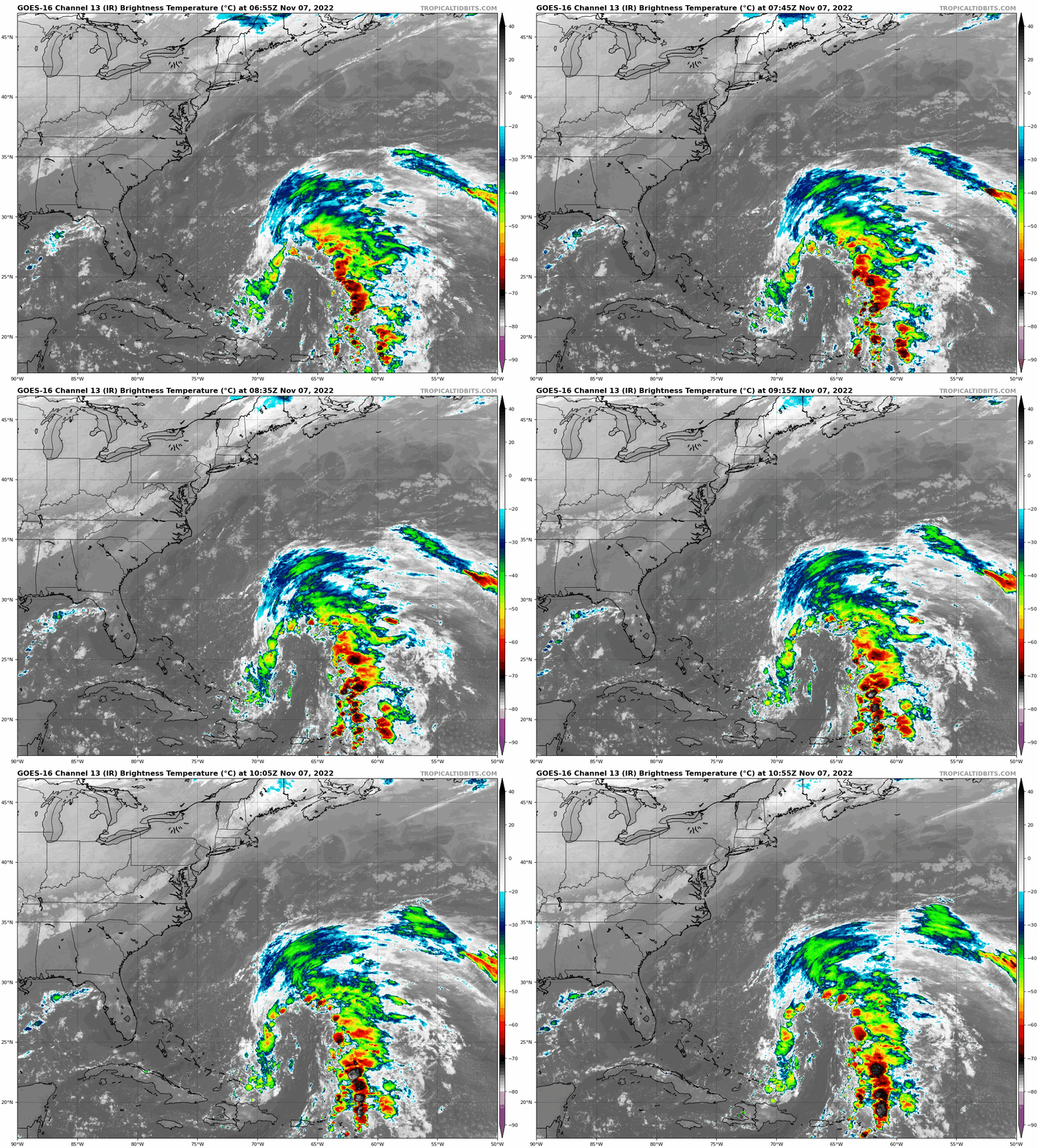
Satellite Loop
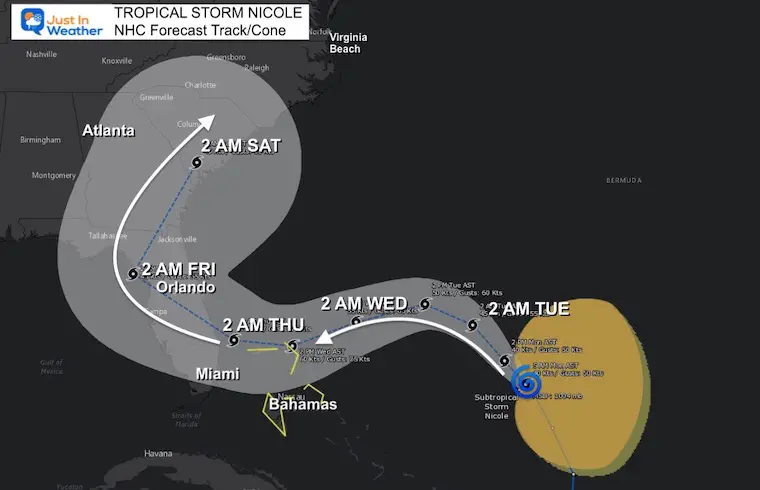
Forecast Track/Cone
Latest projection from the National Hurricane Center using a blend of models. There is a one of uncertainty that allows for adjustment farther out in time as this interacts with the coast and other weather systems.
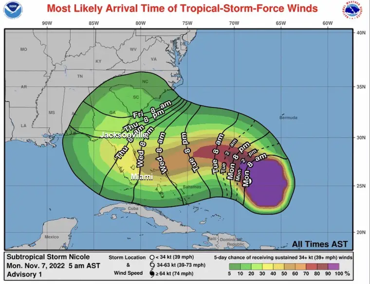
Tropical Storm Wind Arrival Time
Wednesday Evening is the expectation for much of Florida.
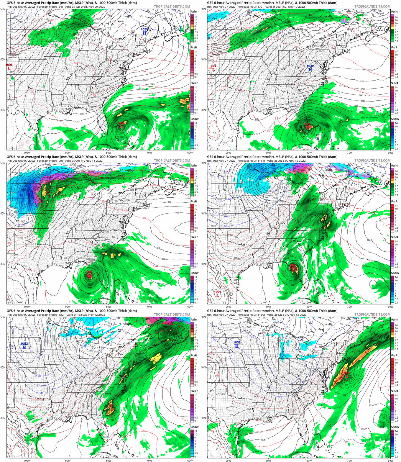
Model Forecast (GFS)
(From Tropical Tidbits)
This shows the storms taking a WIDE TURN by crossing into the Gulf of Mexico and then north up to the Mid Atlantic coast, exiting North Carolina on Saturday.
I expect there will be some adjustments…
Computer Model Forecasts
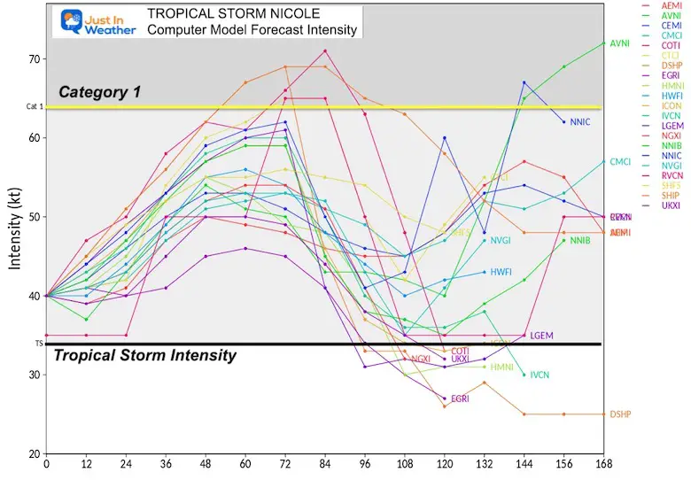
Intensity –
There is some support for this to become a hurricane before landfall.
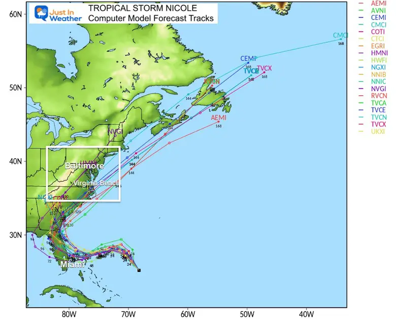
Longer Range Track
Yes, this will turn north somewhere across Florida, then into the Mid Atlantic. It may exit out to the Atlantic from North Carolina…. But heavy rain will expand farther north.
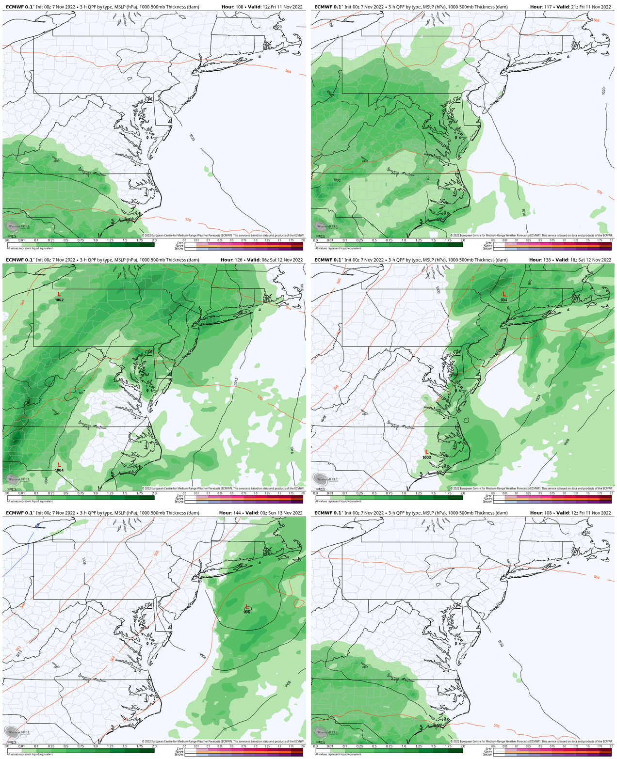
Rain Forecast in the Mid Atlantic ECMWF Model
For contrast, here is the European Model
Friday Morning to Saturday Evening
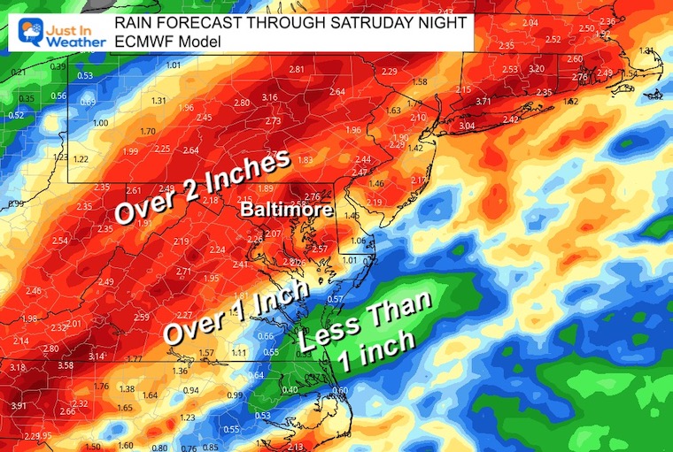
Rainfall Potential
With a large area expecting over 2 inches, there could be some regional flooding.
Please check back for more updates and a focus on the impact for us here in the Mid Atlantic. I will have more details on the expected rain arrival time in my next report.
Weather posts straight to your inbox
Sign up and be the first to know!
Also See: THE BIG COOL DOWN THIS WEEK
Winter Weather Folklore Top 20 And More Outlook Signals From Nature For Cold And Snow
In case you missed this…
Winter Weather Folklore Top 20 And More Outlook Signals From Nature For Cold And Snow
Please share your thoughts, best weather pics/videos, or just keep in touch via social media
-
Facebook: Justin Berk, Meteorologist
-
Twitter: @JustinWeather
-
Instagram: justinweather
STEM Assemblies/In School Fields Trips Are Back
Click to see more and ‘Book’ a visit to your school
Winter Outlook Reports
Farmer’s Almanac Comparison
September Starts Meteorological Autumn: Weather Climate Stats For Maryland at Baltimore
Triple Dip La Niña Winter
CONNECTION TO WINTER?
If you want a snowy winter, this is what you might want to look for in the rest of the tropical season. (You might be seeing a lot of commercial snow removal people out this Winter).
Rainbow Ice Cave In Mt. Rainier A Very Rare Find: Photos And Video
Wooly Bear Caterpillars
https://justinweather.com/2022/10/25/winter-weather-outlook-from-the-wooly-bear-caterpillar/
Persimmon Seeds
Click to see Top 20 and MORE
Winter Weather Folklore Top 20 And More Outlook Signals From Nature For Cold And Snow
Normals And Records: Maryland and Baltimore Climate History
Faith in the Flakes Gear
SNOWSTIX – Available Now


