


Severe Thunderstorm Watch and Flood Watch Tuesday
Tuesday Afternoon Update July 1 2024 The atmosphere is juicy! Dew points are high in the mid to upper 70s, which means there is the potential for heavy rainfall and…
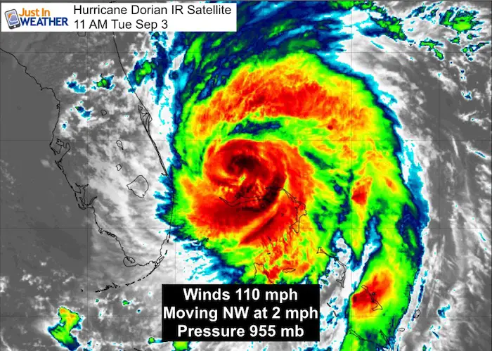
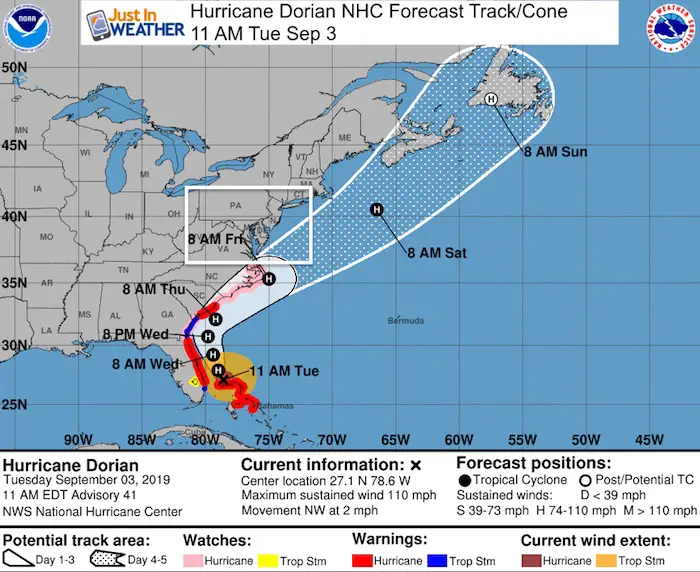
11 AM Tuesday September 3 2019
Hurricane Dorian is still a very powerful storm, so reporting winds ‘down’ to 110 mph can be deceiving. This is now a Category 2 Storm but there is wave memory of a stronger storm still sloshing the ocean off the Florida and Bahamas coasts. The long duration and multiple high tides will bring wide spread beach erosion and flooding even with the storm offshore.
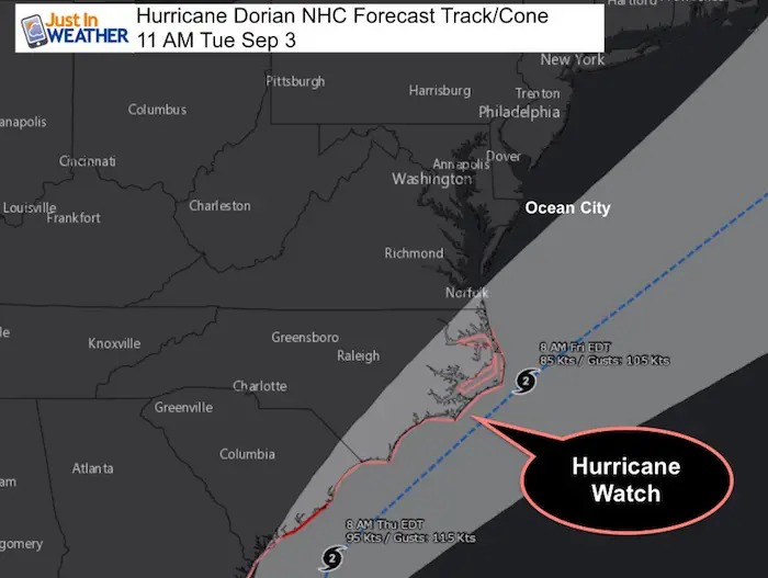
As expected when it weakened, the storm is spreading out to cover a larger area. This is one of the concerns along the US coast. Hurricane Warnings reach to South Carolina and Watches up to eastern North Carolina.
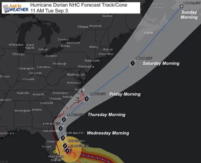
The storm is moving a little bit at 2 mph, but away from Grand Bahama Island and closer to the US.
Hurricane Dorian Stats at 5 AM
Hurricane Dorian IR Satellite
The eye is no longer evident on satellite, but there is still tremendous amount of convection dumping heavy rain, wind, and waves. Outer bands have been reaching Florida all morning.
Hurricane Dorian IR Satellite Loop
Hurricane Dorian Visible Satellite
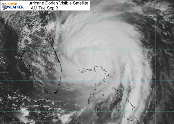
SUMMARY OF 1100 AM EDT...1500 UTC...INFORMATION
-----------------------------------------------
LOCATION...27.1N 78.6W
ABOUT 45 MI...70 KM N OF FREEPORT GRAND BAHAMA ISLAND
ABOUT 105 MI...170 KM E OF FORT PIERCE FLORIDA
MAXIMUM SUSTAINED WINDS...110 MPH...175 KM/H
PRESENT MOVEMENT...NW OR 320 DEGREES AT 2 MPH...4 KM/H
MINIMUM CENTRAL PRESSURE...955 MB...28.20 INCHES
Hurricane Dorian Visible Satellite Loop
Hurricane Dorian Watches and Warnings
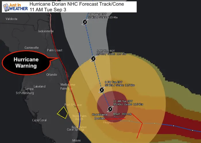
Storm Surge Forecast
Flagler/Volusia County Line FL to Cape Lookout NC...4 to 7 ft
Jupiter Inlet FL to the Flagler/Volusia County Line FL...3 to 5 ft
SUMMARY OF WATCHES AND WARNINGS IN EFFECT:

A Storm Surge Warning is in effect for...
* Jupiter Inlet FL to South Santee River SC

A Storm Surge Watch is in effect for...
* North of South Santee River SC to Cape Lookout NC

A Hurricane Warning is in effect for...
* Grand Bahama and the Abacos Islands in the northwestern Bahamas
* Jupiter Inlet FL to Ponte Vedra Beach FL
* North of Edisto Beach SC to South Santee River SC

A Hurricane Watch is in effect for...
* North of Ponte Vedra Beach FL to Edisto Beach SC
* North of South Santee River SC to Duck NC
* Albemarle and Pamlico Sounds

A Tropical Storm Warning is in effect for...
* North of Deerfield Beach FL to Jupiter Inlet FL
* North of Ponte Vedra Beach FL to Edisto Beach SC

A Tropical Storm Watch is in effect for...
* Lake Okeechobee
Forecast Track/Cone
The forward movement will speed up over the next few days. I’ve highlighted the morning forecast locations to point out the spread of distance each day.
The storm will NOT hit Ocean City directly, but the outer bands are expected to reach the southern half of Delmarva Friday morning.
RAINFALL Forecast:
Dorian is expected to produce the following rainfall
totals through Friday:

Northwestern Bahamas...Additional 2 to 4 inches, isolated storm
totals over 30 inches.
Coastal Carolinas...5 to 10 inches, isolated 15 inches.
Atlantic Coast from the Florida peninsula north of West Palm Beach
through Georgia...3 to 6 inches, isolated 9 inches.
Southeast Virginia...2 to 4 inches, isolated 6 inches.

This rainfall may cause life-threatening flash floods.
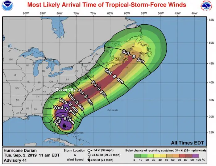
Wind Speed Arrive (TS over 39 mph)
There is a 40% chance of sustained winds over 39 mph in Ocean City, MD Friday morning.
National Hurricane Center Official Forecast
Just in case you don’t get all posts on your social media feed, stay up to date with the latest info…
Click here to sign up for email alerts…. Be the first to hear any new weather
Thank you to our Title Sponsor for Maryland Trek 6
Shining on with Smyth and their contribution, our team has raised over $95,000 for Just In Power Kids to provide free programs for kids in and post cancer treatment.

Please share your thoughts, best weather pics/video, or just keep in touch via social media
Maryland Trek Cycle Jerseys From Hill Killer
All proceeds will go to the Maryland Trek 6 total and Just In Power Kids programs

Just In Power Kids:
Proceeds go to our programs Providing FREE holistic care for kids in cancer treatment and up to 5 years post treatment and caregivers.
![]()
Shine On
Proceeds from all sales go to Just In Power Kids. Click the image to shop and show your support.

Love Maryland Shirts and Hoodies
This shirt was designed by my ‘bonus’ daughter Jaiden. The hoodie has been the biggest hit, so our promotion has been extended until the end of this week.
|
||
|
Show your love for Maryland and make this 14 year old artist and her mom extra proud
|
Related Links:
Was Your County Not Included?
Click this map for more on the regional forecast zones
